Crash of a De Havilland DHC-3T Turbo Otter off Vomo Island

Date & Time: Dec 29, 2009 at 1800 LT
Type of aircraft:
Operator:
Registration:
DQ-GLL
Survivors:
Yes
Schedule:
Nadi - Vomo Island
MSN:
288
YOM:
1958
Country:
Region:
Crew on board:
1
Crew fatalities:
Pax on board:
5
Pax fatalities:
Other fatalities:
Total fatalities:
0
Circumstances:
While approaching Vomo Island, near Viti Levu Island, Fiji, the single engine aircraft crashed into the sea few dozen metres offshore. All six occupants were slightly injured while the aircraft was damaged beyond repair.

Crash of a Boeing 737-800 in Kingston

Date & Time: Dec 22, 2009 at 2222 LT
Type of aircraft:
Operator:
Registration:
N977AN
Survivors:
Yes
Schedule:
Washington DC - Miami - Kingston
MSN:
29550/1019
YOM:
2001
Flight number:
AA331
Country:
Crew on board:
6
Crew fatalities:
Pax on board:
148
Pax fatalities:
Other fatalities:
Total fatalities:
0
Circumstances:
American Airlines Flight AA331, a Boeing 737-823 in United States registration N977AN, carrying 148 passengers, including three infants, and a crew of six, was being operated under the provisions of 14 Code of Federal Regulations (CFR) Part 121. The aircraft departed Miami (KMIA) at 20:22 Eastern Standard Time (EST) on 22 December 2009 (01:22 Universal Coordinated Time (UTC) on 23 December 2009) on an instrument flight rules (IFR) flight plan, on a scheduled flight to Norman Manley International Airport (NMIA), ICAO identifier: MKJP, Kingston, Jamaica. The aircraft landed at NMIA on runway 12 in the hours of darkness at 22:22 EST (03:22 UTC) in Instrument Meteorological Conditions (IMC) following an Instrument Landing System (ILS) approach flown using the heads up display (HUD) and becoming visual at approximately two miles from the runway. The aircraft touched down at approximately 4,100 feet on the 8,911 foot long runway in heavy rain and with a 14 knot left quartering tailwind. The crew was unable to stop the aircraft on the remaining 4,811 feet of runway and it overran the end of the runway at 62 knots ground speed. The aircraft broke through a fence, crossed above a road below the runway level and came to an abrupt stop on the sand dunes and rocks between the road and the waterline of the Caribbean Sea. There was no post-crash fire. The aircraft was destroyed, its fuselage broken into three sections, while the left landing gear collapsed. The right engine and landing gear were torn off, the left wingtip was badly damaged and the right wing fuel tanks were ruptured, leaking jet fuel onto the beach sand. One hundred and thirty four (134) passengers suffered minor or no injury, while 14 were seriously injured, though there were no life-threatening injuries. None of the flight crew and cabin crew was seriously injured, and they were able to assist the passengers during the evacuation.
Probable cause:
Jamaican Director General of Civil Aviation Col. Oscar Derby, stated in the week following the accident, that the jet touched down about halfway down the 8,910-foot (2,720 m) runway. He also noted that the 737-800 was equipped with a head-up display. Other factors that were under investigation included "tailwinds, and a rain soaked runway;" the runway in question was not equipped with rain-dispersing grooves common at larger airports. The aircraft held a relatively heavy fuel load at the time of landing; it was carrying enough fuel for a round trip flight back to the US. The FDR later revealed that the aircraft touched down some 4,100 feet (1,200 m) down the 8,910-foot (2,720 m) long runway. Normally touchdown would be between 1,000 feet (300 m) and 1,500 feet (460 m). The aircraft was still traveling at 72 miles per hour (116 km/h) when it departed the end of the runway. The aircraft landed with a 16 miles per hour (26 km/h) tailwind, just within its limit of 17 miles per hour (27 km/h).
Final Report:

Crash of a Boeing 737-301 in Ujung Pandang

Date & Time: Dec 21, 2009 at 0151 LT
Type of aircraft:
Operator:
Registration:
PK-MDH
Survivors:
Yes
Schedule:
Surabaya – Ujung Pandang
MSN:
23932/1554
YOM:
1988
Flight number:
MZ766
Country:
Region:
Crew on board:
6
Crew fatalities:
Pax on board:
102
Pax fatalities:
Other fatalities:
Total fatalities:
0
Circumstances:
Following an uneventful flight from Surabaya-Juanda Airport, the crew started a night approach to Ujung Pandang-Sultan Hasanuddin Airport (Makassar). On short final, at a height of 50 feet, the aircraft descended fast and landed nose first. A tyre burst on impact and the aircraft was stopped following a normal landing course. All 108 occupants evacuated safely and the aircraft was damaged beyond repair due to fuselage damages.

Crash of a Swearingen SA227AC Metro III in Cap Haïtien

Date & Time: Dec 20, 2009 at 1200 LT
Type of aircraft:
Operator:
Registration:
C6-JER
Survivors:
Yes
Schedule:
Nassau – Cap Haïtien
MSN:
AC-588B
YOM:
1984
Country:
Crew on board:
2
Crew fatalities:
Pax on board:
19
Pax fatalities:
Other fatalities:
Total fatalities:
0
Captain / Total flying hours:
7400
Circumstances:
On Sunday December 20, 2009 at approximately 1700 UTC a fixed wing, multi engine, Fairchild SA-227AC Metro-liner III aircraft landed at Cap Haïtien Int’l Airport, Haiti, with its landing gear retracted. The pilot reported on two occasions whilst the aircraft was configured with flaps and gear extended, upon reduction in power preparing to land, the aircraft had a very high nose up attitude. The pilot further stated that after two go around, the decision was made to land the aircraft with its landing gear retracted. The aircraft landed on Runway 05. According to the pilot, the crew and all 19 passengers onboard suffered no injuries.
Final Report:

Crash of an Avro 748-398-2B in Tonj: 1 killed

Date & Time: Dec 20, 2009
Type of aircraft:
Operator:
Registration:
5Y-YKM
Survivors:
Yes
Schedule:
Juba - Tonj
MSN:
1779
YOM:
1981
Country:
Region:
Crew on board:
4
Crew fatalities:
Pax on board:
37
Pax fatalities:
Other fatalities:
Total fatalities:
1
Aircraft flight hours:
15620
Circumstances:
After landing at Tonj Airfield, the aircraft that was unable to stop within the remaining distance. It overran and came to rest against houses. All 41 occupants escaped uninjured while a woman was killed on the ground. The aircraft departed Juba on a charter flight to Tonj, carrying security personnel from the Presidency who should prepare the next visit of the President of South Sudan in Tonj.

Crash of a Dassault Falcon 20D in Matthew Town: 2 killed

Date & Time: Dec 17, 2009 at 1930 LT
Type of aircraft:
Operator:
Registration:
N28RK
Flight Type:
Survivors:
No
Schedule:
Oranjestad – La Isabela – Fort Lauderdale
MSN:
206
YOM:
1969
Country:
Crew on board:
2
Crew fatalities:
Pax on board:
0
Pax fatalities:
Other fatalities:
Total fatalities:
2
Captain / Total flying hours:
26525
Copilot / Total flying hours:
4800
Circumstances:
On December 17, 2009 at approximately 7:30 pm local (2330UTC), N28RK a Dassault Sud, Falcon Fan Jet, Mystere 20, Series D aircraft which departed Joaquin Balaguer Int’l Airport (MDJB) in the Dominican Republic, for Ft Lauderdale Executive Airport, (FXE) Ft Lauderdale, Florida, USA, crashed in a remote area of Matthew Town, Great Inagua, Bahamas. The accident occurred approximately 11.5 miles due east of Great Inagua International Airport at coordinates N 20˚ 58’ 30” latitude and W 073˚ 40’ 00.7” longitude. The aircraft made contact with the terrain on a heading of approximately 105 degrees magnetic. The accident occurred in area that was not accessible by land and the investigation team had to be airlifted by helicopter to the site. Witnesses on the island of Great Inagua reported hearing a loud bang that rattled doors and windows of their homes, but they did not report seeing the aircraft fall from the sky. The aircraft was under the command of Captain Harold Roy Mangels and First Office Freddy Castro. The aircraft reportedly departed Aruba, in the Netherland Antilles and made a fuel stop at Dr. Joaquin Balaguer Int’l Airport, Santo Domingo in the Dominican Republic. The final destination filed by the crew was Ft. Lauderdale Executive Airport, Ft Lauderdale Florida. The accident occurred approximately 6 mile off the filed flight path. ATC records and instructions were for the aircraft N28RK to maintain 28,000 ft (FL280). The aircraft transponder was reported as inoperative. It begun a rapid descent, with no report of an emergency declared or mayday call out. Investigation of the crash site indicates the airplane made contact with the terrain at a high rate of speed and approximately a 45 degree angle. The aircraft was destroyed on impact. The crew of a United States Coast Guard helicopter was on a training mission in the Great Inagua area at the time of the accident. They reported hearing a loud bang and noticed a huge explosion and fireball emanating from the ground in an area close to their location. The crew of the US Coast Guard helicopter reported that they did not see any in-flight fire prior to the fireball that they saw. The post impact fire engulfed approximately five (5) acres of trees and brush in the National Wildlife Refuge at Great Inagua. The coast guard helicopter crew stated that they discontinued their training mission and went to the site to investigate. Upon arrival at the site the crew reported that they lowered rescue personnel to the ground to investigate and search for survivors, but, due to the heat and extent of the fire on the ground, they had to discontinue the search. They reported the accident to authorities at Great Inagua. This information was further passed along to the National Transportation Safety Board who alerted the accident investigation unit of the Bahamas Civil Aviation Department. Night time conditions prevailed at the time of the accident. The crew of the aircraft received fatal injuries. A search of the area discovered no distinguishable human remains. Approximately less than 1% of what is believed to be possible human flesh / internal body parts were recovered. In addition clothing (piece of a pant with belt buckle fastened) was recovered, which possibly may have been worn by a member of the crew at the time of the accident. All recovered remains and clothing retrieved were gathered by officers of the Royal Bahamas Police Force that accompanied the investigation team and sent to the Forensic Science Laboratory at the Royal Bahamas Police Force, Nassau Bahamas for DNA analysis and possible identification. The aircraft broke into many pieces after contact with the terrain. Debris was spread over a large area of rough terrain. What remained of the aircraft post impact was either not found or possibly further destroyed by the post impact fire. The “four corners” of the airplane were confirmed in the area downstream of where the initial ground impact occurred. However, engine cowling parts were found prior to the point of initial ground impact. This may suggest an aircraft over-speed condition prior to ground impact. Less than 10% of the aircraft was recovered. An explosion occurred when N28RK made contact with the terrain. A post impact fire ensued. Approximately 5 acres of the national park was destroyed by the fire. Parts of the aircraft including personal effect, aircraft parts and furnishing, seat and seat cushions were also destroyed in the post impact fire.
Probable cause:
The probable cause of this accident has been determined as loss of control. Insufficient wreckage of the aircraft were recovered to make a conclusive determination as to the cause of the accident.
Final Report:

Crash of a Socata TBM-850 in Truckee

Date & Time: Dec 13, 2009 at 1738 LT
Type of aircraft:
Registration:
N850MT
Flight Type:
Survivors:
Yes
Schedule:
San Carlos – Truckee
MSN:
489
YOM:
2008
Crew on board:
1
Crew fatalities:
Pax on board:
1
Pax fatalities:
Other fatalities:
Total fatalities:
0
Captain / Total flying hours:
1738
Captain / Total hours on type:
1098.00
Aircraft flight hours:
196
Circumstances:
During the flight, the instrument-rated private pilot was monitoring the weather at his intended destination. He noted the weather and runway conditions and decided to conduct a global-positioning-system instrument approach to a known closed runway with the intention of circling to a different runway. As the airplane neared the missed approach point, the pilot established visual contact with the airport's runway environment and canceled his instrument flight rules clearance. As he entered the left downwind leg of the traffic pattern for his intended runway, the pilot noticed that the first part of the runway was covered in fog and that the visibility was 0.75 of a mile with light snow. With at least 5,000 feet of clear runway, he opted to land just beyond the fog. Prior to touchdown, the pilot concluded that there was not enough runway length left to make a landing and performed a go-around by applying power, pitching up, and retracting the landing gear. During the go-around, the pilot focused outside the airplane cockpit but had no horizon reference in the dark night conditions. He heard the stall warning and realized that the aircraft was not climbing. The pilot pitched the nose down and observed only snow and trees ahead. Not being able to climb over the trees, the airplane subsequently impacted trees and terrain, coming to rest upright in a wooded, snow-covered field. The pilot stated that there were no anomalies with the engine or airframe that would have precluded normal operation of the airplane.
Probable cause:
The pilot’s failure to maintain an adequate airspeed and clearance from terrain during an attempted go-around. Contributing to the accident was the pilot's decision to land on a partially obscured runway.
Final Report:

Crash of a Beechcraft A100 King Air in Chicoutimi: 2 killed

Date & Time: Dec 9, 2009 at 2250 LT
Type of aircraft:
Operator:
Registration:
C-GPBA
Survivors:
Yes
Schedule:
Val d'Or - Chicoutimi
MSN:
B-215
YOM:
1975
Flight number:
ET822
Country:
Crew on board:
2
Crew fatalities:
Pax on board:
2
Pax fatalities:
Other fatalities:
Total fatalities:
2
Captain / Total flying hours:
3500
Captain / Total hours on type:
1000.00
Copilot / Total flying hours:
1000
Copilot / Total hours on type:
150
Circumstances:
The Beechcraft was on an instrument flight rules flight between Val-d’Or and Chicoutimi/Saint-Honoré, Quebec, with 2 pilots and 2 passengers on board. At 2240 Eastern Standard Time, the aircraft was cleared for an RNAV (GNSS) Runway 12 approach and switched to the aerodrome traffic frequency. At 2250, the International satellite system for search and rescue detected the aircraft’s emergency locator transmitter signal. The aircraft was located at 0224 in a wooded area approximately 3 nautical miles from the threshold of Runway 12, on the approach centreline. Rescuers arrived on the scene at 0415. The 2 pilots were fatally injured, and the 2 passengers were seriously injured. The aircraft was destroyed on impact; there was no post-crash fire.
Probable cause:
Findings as to Causes and Contributing Factors:
For undetermined reasons, the crew continued its descent prematurely below the published approach minima, leading to a controlled flight into terrain (CFIT).
Findings as to Risk:
1. The use of the step-down descent technique rather than the stabilized constant descent angle (SCDA) technique for non-precision instrument approaches increases the risk of an approach and landing accident (ALA).
2. The depiction of the RNAV (GNSS) Runway 12 approach published in the Canada Air Pilot (CAP) does not incorporate recognized visual elements for reducing ALAs, as recommended in Annex 4 to the Convention, thereby reducing awareness of the terrain.
3. The installation of a terrain awareness warning system (TAWS) is not yet a requirement under the Canadian Aviation Regulations (CARs) for air taxi operators. Until the changes to regulations are put into effect, an important defense against ALAs is not available.
4. Most air taxi operators are unaware of and have not implemented the FSF ALAR task force recommendations, which increases the risk of a CFIT accident.
5. Approach design based primarily on obstacle clearance instead of the 3° optimum angle increases the risk of ALAs.
6. The lack of information on the SCDA technique in Transport Canada reference manuals means that crews are unfamiliar with this technique, thereby increasing the risk of ALAs.
7. Use of the step-down descent technique prolongs the time spent at minimum altitude, thereby increasing the risk of ALAs.
8. Pilots are not sufficiently educated on instrument approach procedure design criteria. Consequently, they tend to use the CAP published altitudes as targets, and place the aircraft at low altitude prematurely, thereby increasing the risk of an ALA.
9. Where pilots do not have up-to-date information on runway conditions needed to check runway contamination and landing distance performance, there is an increased risk of landing accidents.
10. Non-compliance with instrument flight rules (IFR) reporting procedures at uncontrolled airports increases the risk of collision with other aircraft or vehicles.
11. If altimeter corrections for low temperature and remote altimeter settings are not accurately applied, obstacle clearance will be reduced, thereby increasing the CFIT risk.
12. When cockpit recordings are not available to an investigation, this may preclude the identification and communication of safety deficiencies to advance transportation safety.
13. Task-induced fatigue has a negative effect on visual and cognitive performance which can diminish the ability to concentrate, operational memory, perception and visual acuity.
14. Where an emergency locator transmitter (ELT) is not registered with the Canadian Beacon Registry, the time needed to contact the owner or operator is increased which could affect occupant rescue and survival.
15. If the tracking of a call to 911 emergency services from a cell phone is not accurate, search and rescue efforts may be misdirected or delayed which could affect occupant rescue and survival.
Other Findings:
1. Weather conditions at the alternate airport did not meet CARs requirements, thereby reducing the probability of a successful approach and landing at the alternate airport if a diversion became necessary.
2. Following the accident, none of the aircraft exits were usable.
Final Report:

Crash of a Beechcraft F90 King Air in Egelsbach: 3 killed

Date & Time: Dec 7, 2009 at 1616 LT
Type of aircraft:
Operator:
Registration:
D-IDVK
Survivors:
No
Schedule:
Bremen - Egelsbach
MSN:
LA-96
YOM:
1981
Location:
Country:
Region:
Crew on board:
1
Crew fatalities:
Pax on board:
2
Pax fatalities:
Other fatalities:
Total fatalities:
3
Captain / Total flying hours:
2200
Aircraft flight hours:
6069
Aircraft flight cycles:
5353
Circumstances:
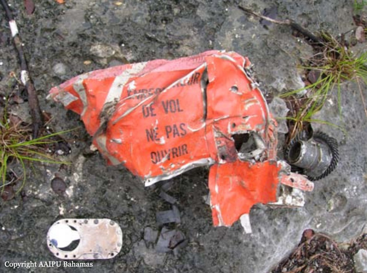
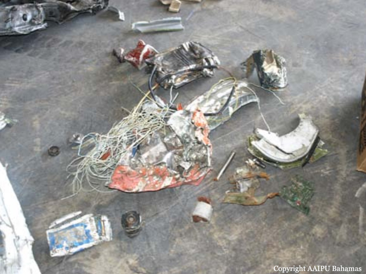
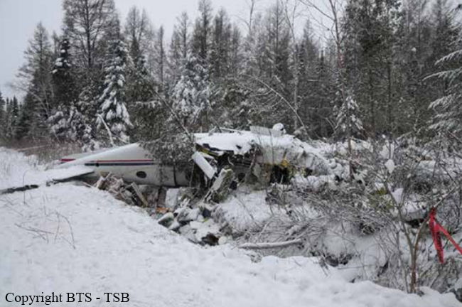
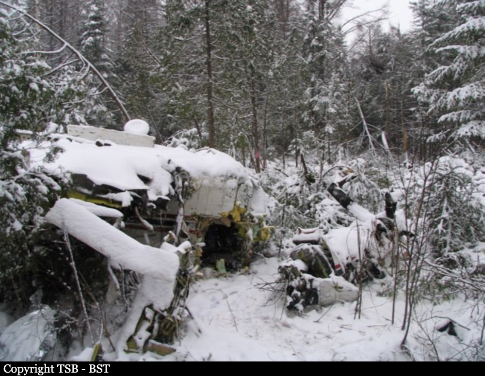
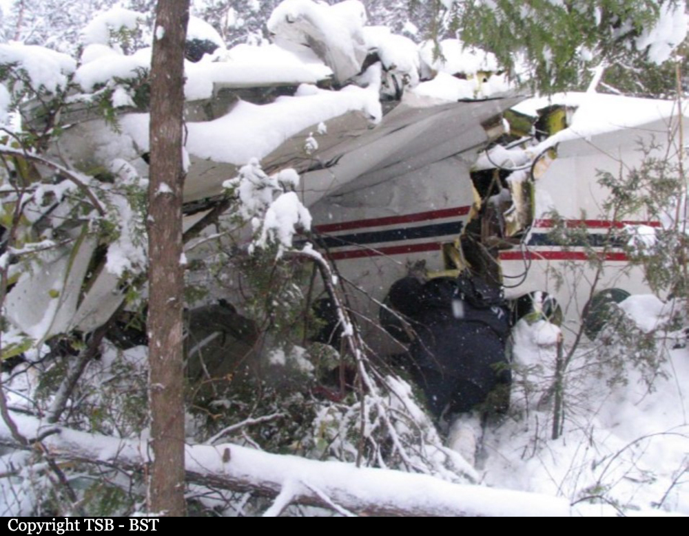
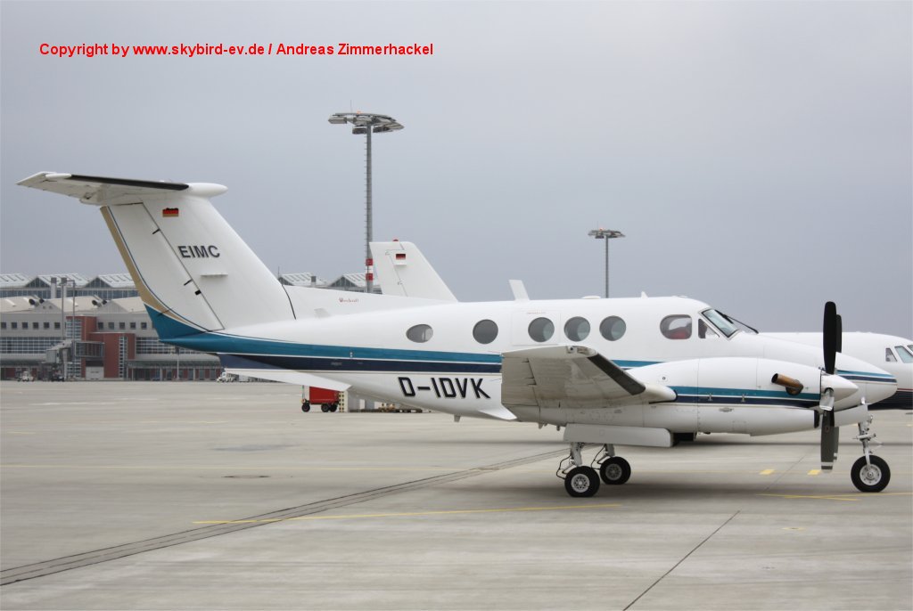
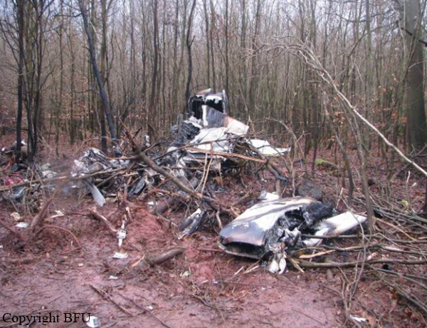
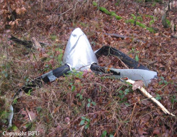
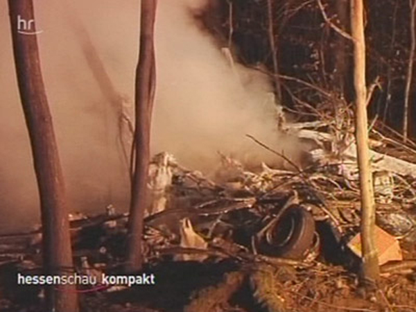
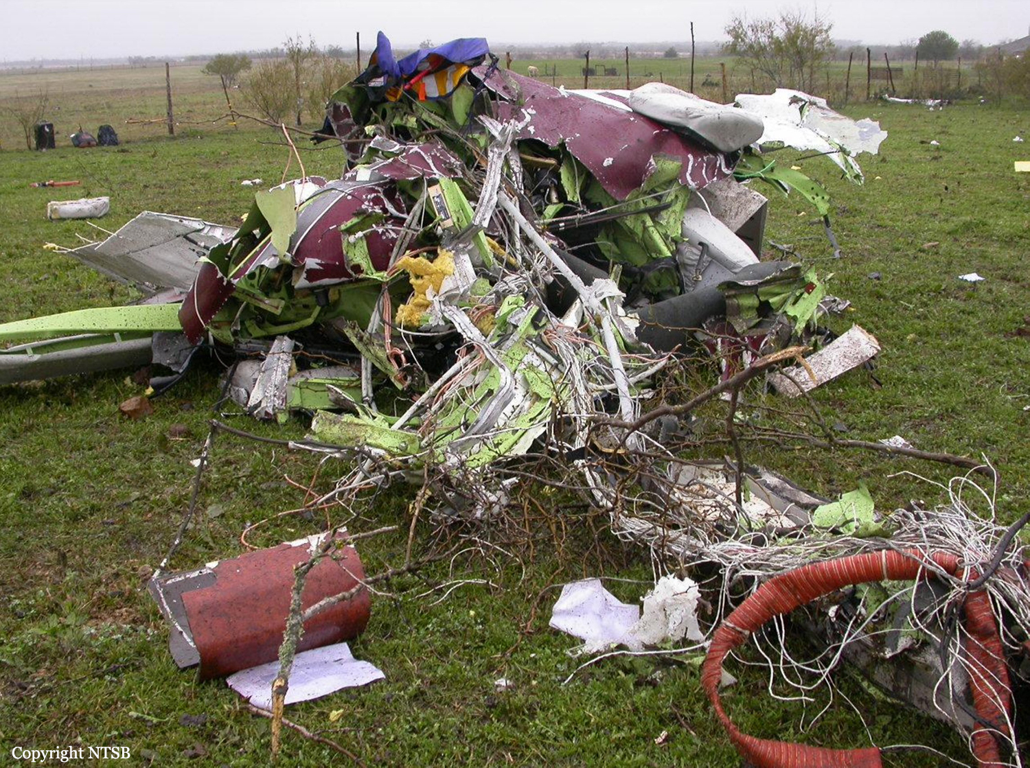
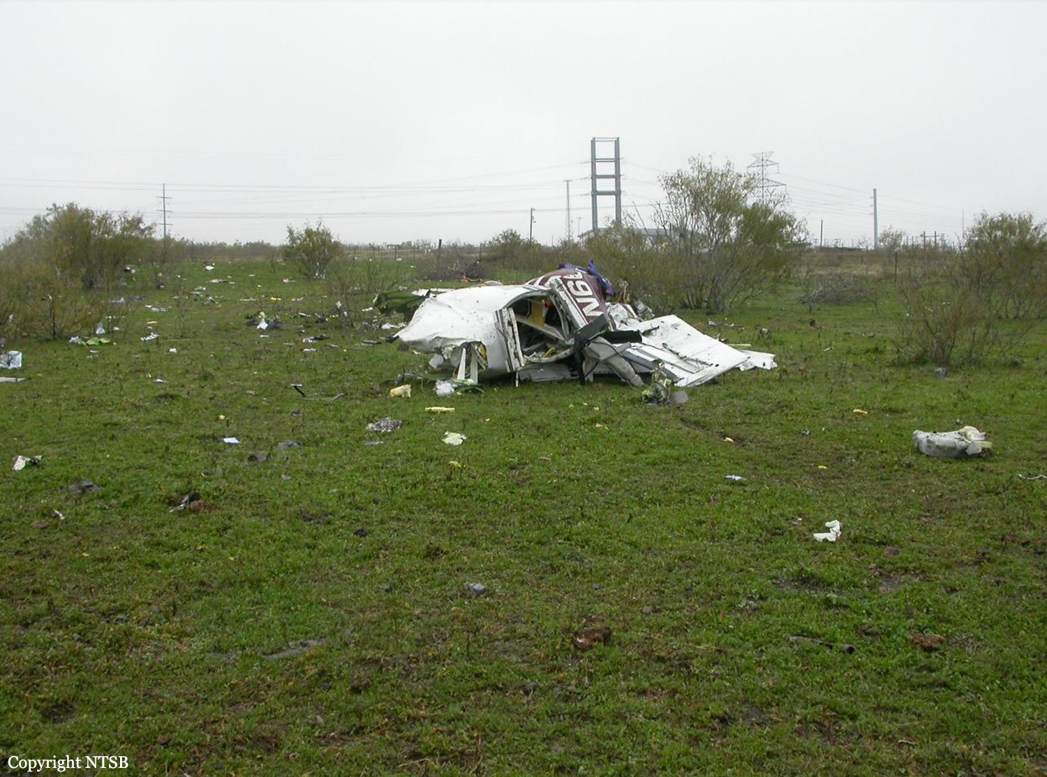
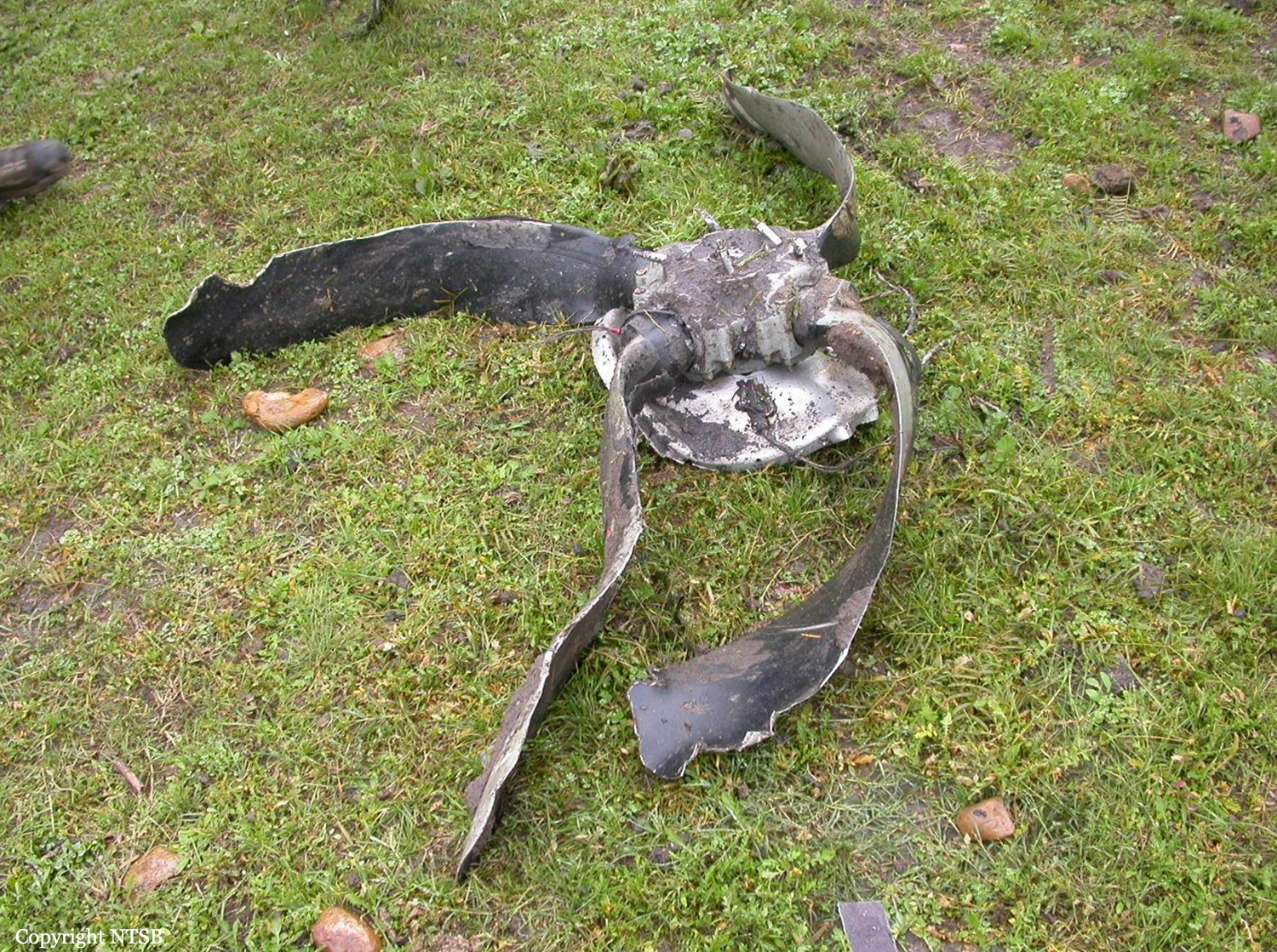
On a flight from Bremen (EDDW) to Frankfurt-Egelsbach (EDFE), a Beechcraft King Air (F90) changed from IFR to VFR rules prior to the final approach, during which it collided with trees, crashing in a wood and catching fire. On board were the pilot and two passengers. The right hand cockpit seat was occupied by a passenger who conducted radio communications. The approach to runway 27 at EDFE was chosen and executed via the so-called High Performance Aircraft Approach (HPA-approach) as published in the Aeronautical Information Publication (AIP). From 1558 hrs onwards the aircraft was under control by Langen Radar (120.8 MHz), and radar contact was confirmed by the controller. After about six minutes the controller issued the instruction: “[call sign], report if able to cancel IFR”. Subsequently, further instructions were issued to descend to altitude 5,000 ft on QNH 1,012 hPa and fly towards Egelsbach entry point Hotel 1. About four minutes later the controller gave instructions to descend to 4,000 ft, then 3,000 ft. Simultaneously, clearance was given to fly from entry point Hotel 1 to Hotel 2 and then Hotel 3. When overhead entry point Hotel 2 at 1613 hrs, the King Air reported flight conditions as ‘Victor Mike Charlie’ (VMC – Visual Meteorological Conditions) and the switch to VFR (Visual Flight Rules). At this time, the radar recorded the aircraft’s ground speed as about 180 kt. Langen Radar confirmed the report and gave an instruction to continue the descent and report passing 1,500 ft. About 42 seconds later the pilot was instructed to contact Egelsbach Info (130.9 MHz). The radar trace indicated that at this time the aircraft was at an altitude of about 1,800 ft and about 5.5 NM from the airfield. The ground speed was about 180 kt. The first radio call from the Beech to Egelsbach Info took place about 15 seconds later at 1615:06 hrs, at an altitude of about 1,500 ft and ground speed of about 190 kt. Egelsbach Info gave the information that the aircraft was north of the approach centreline and asked for a course correction to the left. They further reported the wind as Easterly at 4 knots with Runway 27 in use. After the response “[call sign], thank you” Egelsbach Info responded: “lights and flashes are on“. During the subsequent approach, the aircraft ground speed reduced over a distance of about 1.3 NM from about 190 kt to about 130 kt (distance to aerodrome about 3 NM). The radar trace indicates that from a position of 3.7 NM from the aerodrome to 2.5 NM from the aerodrome, the aircraft descended from 1,500 ft to 1,000 ft.At about 1616:03 hrs Egelsbach Info advised: “[…]coming up onto centreline”. This was acknowledged with “[call sign]”, following which Egelsbach Info advised: “you are now on centreline”. This was acknowledged with “thank you very much“. The radar trace indicates that at this time the aircraft descended from 900 ft to 800 ft. When Egelsbach Info advised “check your altitude”, the aircraft was at an altitude of about 800 ft. After a further two seconds, at 1616:18 hrs, the radar data indicated the aircraft height as about 700 ft; there was no more indication on the radar screen afterwards. In this area, the terrain is about 620 ft, with trees extending to about 700 ft AMSL. At 1616:24 hrs the aircraft was requested by Egelsbach Info to alter course slightly to the right. Neither a reply was received to this request nor to a subsequent transmission from Egelsbach Info about 22 seconds later. Egelsbach Info assumed there had been a crash and alerted the emergency services, the first of which arrived at the accident site at about 1638 hrs and found a burning wreck.
Probable cause:
The accident was caused by the descent during final approach which led into a fog layer and obstacles.
Contributing factors were:
- A too high descent rate
- An impaired performance and an insufficient situational awareness favored by the intake of alcohol
- That no visual contact with the PAPI or airfield was established
- That the on-board aids to navigation were not or not sufficiently used.
Final Report:

Crash of a Piper PA-46-500TP Malibu Meridian in Mendoza: 2 killed

Date & Time: Dec 7, 2009 at 1134 LT
Operator:
Registration:
N600YE
Flight Type:
Survivors:
No
Schedule:
Rockport – Austin
MSN:
46-97250
YOM:
2006
Location:
Crew on board:
1
Crew fatalities:
Pax on board:
1
Pax fatalities:
Other fatalities:
Total fatalities:
2
Captain / Total flying hours:
3513
Circumstances:
The pilot was established on the localizer portion of the instrument landing system approach outside the final approach fix in visual meteorological conditions above clouds. He was then given vectors away from the localizer course by an air traffic controller. The vectors were close together and included a left 90-degree turn, a descent, and a 180-degree right turn back toward the localizer course. During the right turn and descent, the airplane continued turning with increasing bank and subsequently impacted the ground. According to a pilot weather report and flight path data the pilot entered clouds as he was starting the right turn toward the localizer. The combination of descending turns while entering instrument conditions were conducive to spatial disorientation. Further, the heading changes issued by the air traffic controller were rapid, of large magnitude, and, in combination with a descent clearance, likely contributed to the pilot’s disorientation. Diphenhydramine, a drug that may impair mental and/or physical abilities, was found in the pilot’s toxicological test results. While the exact effect of the drug at the time of the accident could not be determined, it may have contributed to the development of spatial disorientation.
Probable cause:
The pilot’s spatial disorientation, which resulted in his loss of airplane control. Contributing to the pilot's spatial disorientation was the sequence and timing of the instructions issued by the air traffic controller. The pilot’s operation of the airplane after using impairing medication may also have contributed.
Final Report: