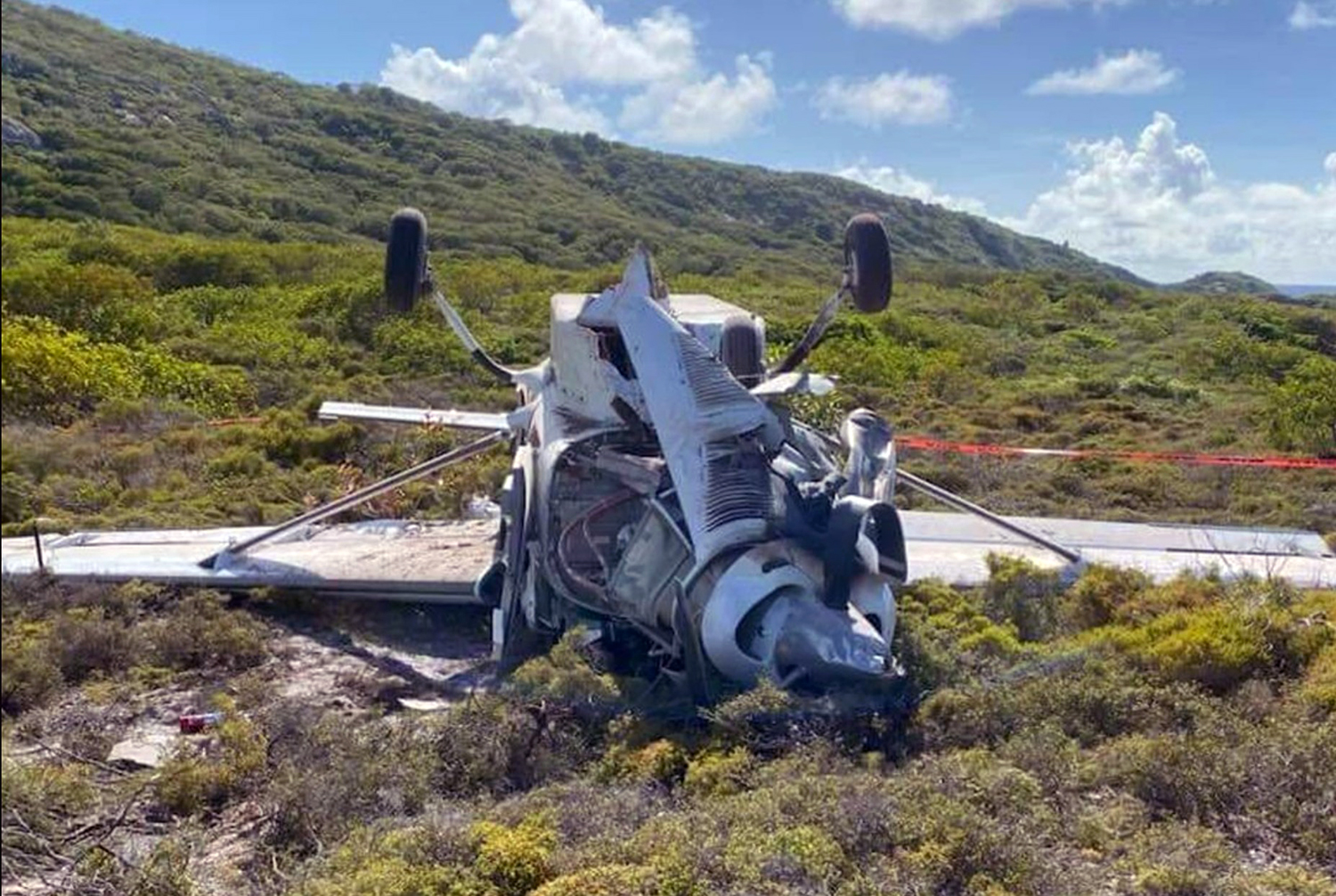
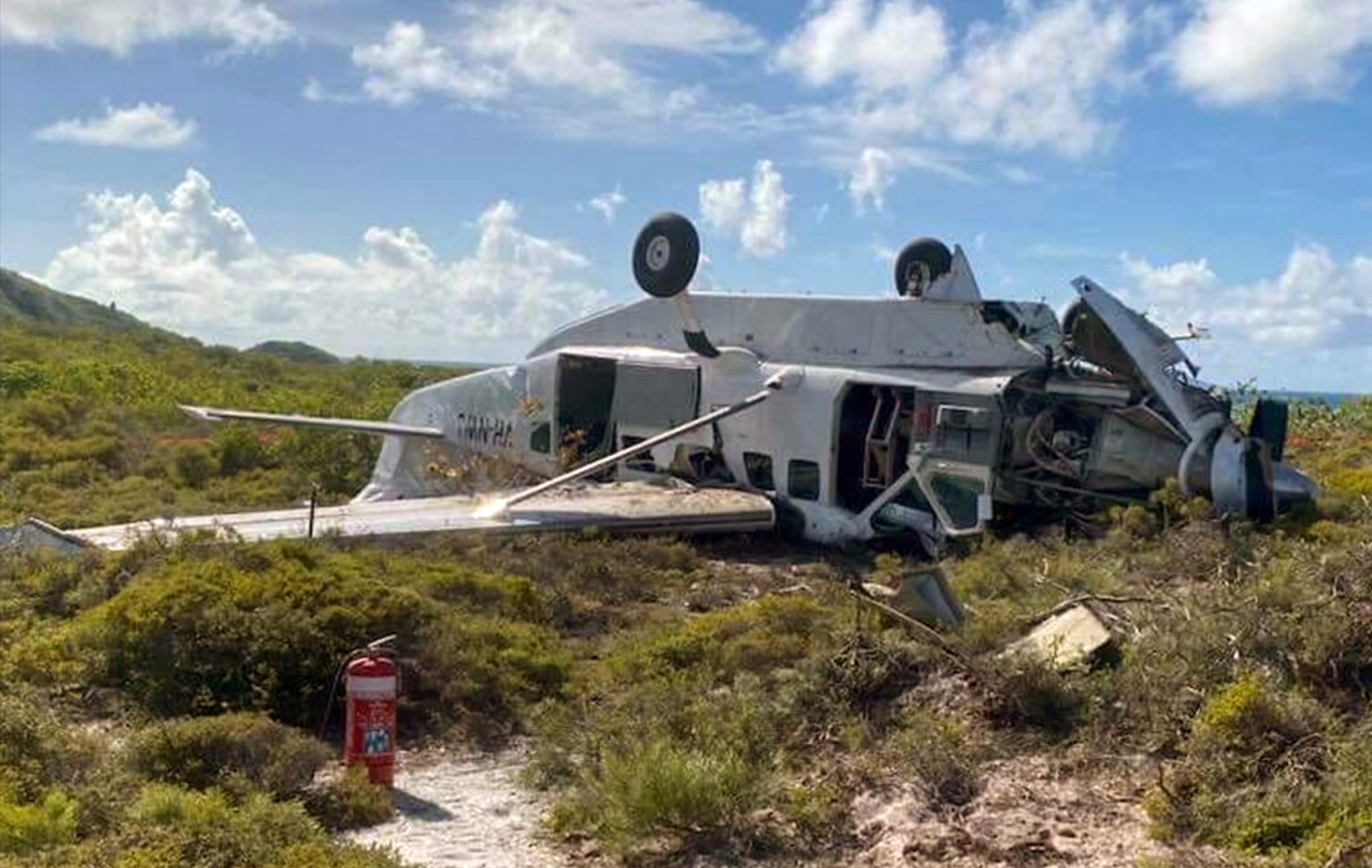
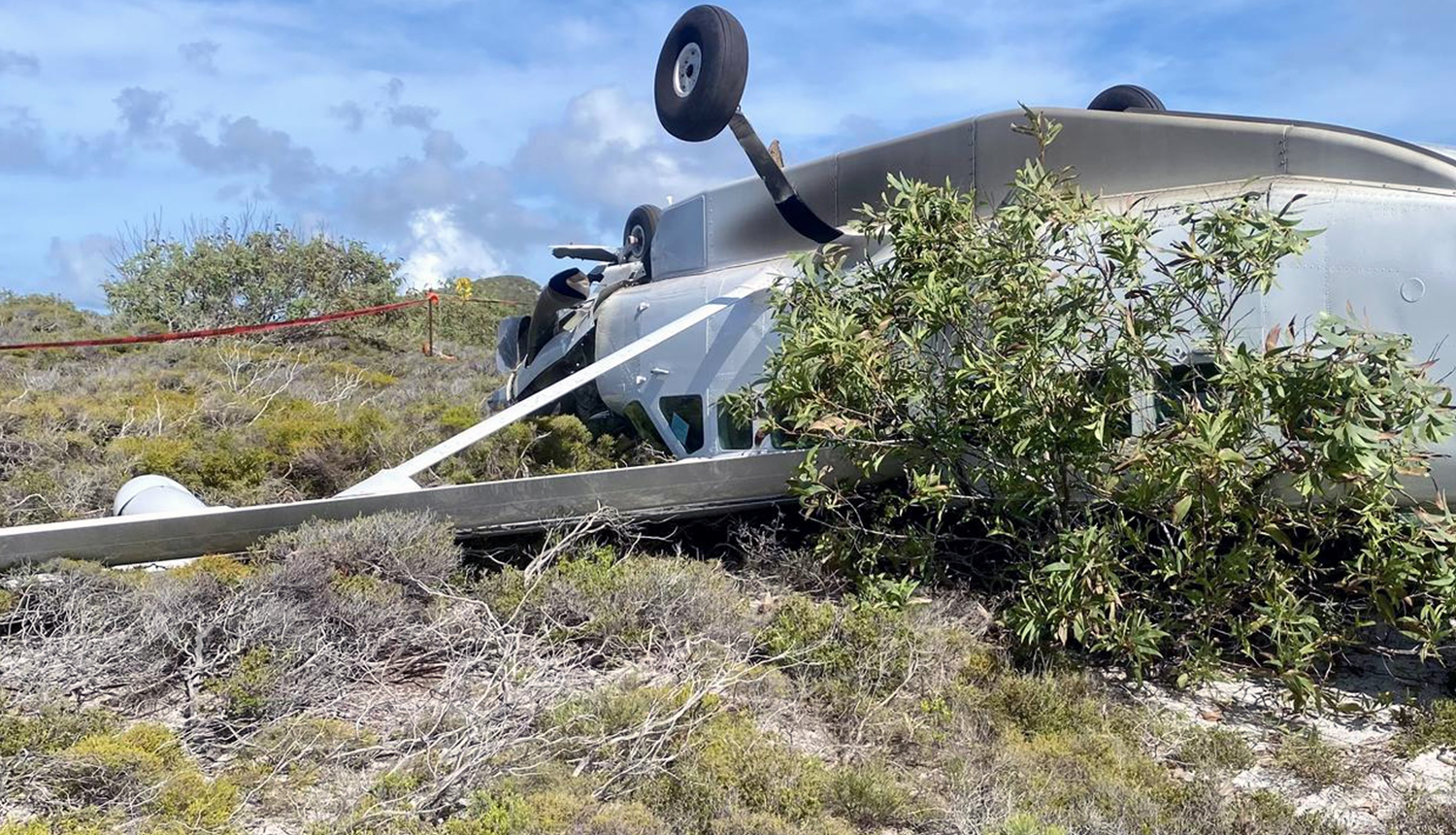
Crash of a Piper PA-31-350 Navajo Chieftain in Hillcrest

Date & Time: Apr 7, 2023 at 0605 LT
Operator:
Registration:
VH-HJE
Flight Phase:
Flight Type:
Survivors:
Yes
Schedule:
Bankstown – Brisbane
MSN:
31-7852074
YOM:
1978
Country:
Region:
Crew on board:
1
Crew fatalities:
Pax on board:
0
Pax fatalities:
Other fatalities:
Total fatalities:
0
Circumstances:
The twin engine airplane departed Bankstown Airport on a cargo flight to Brisbane, carrying one pilot and medical stuffs. While descending to Brisbane-Archerfield Airport, the pilot encountered technical problems with the engines that lost power and attempted an emergency landing. The airplane impacted trees and crashed in a grassy area located along a railway road in Hillcrest, some 10 km south of Archerfield Airport. The pilot escaped with minor injuries.

Crash of a Pacific Aerospace PAC 750XL in Kudjip

Date & Time: Feb 9, 2023 at 1300 LT
Operator:
Registration:
P2-BJD
Flight Phase:
Survivors:
Yes
Schedule:
Giramben - Simbai
MSN:
124
YOM:
2005
Location:
Region:
Crew on board:
1
Crew fatalities:
Pax on board:
3
Pax fatalities:
Other fatalities:
Total fatalities:
0
Circumstances:
The single engine airplane departed Giramben Airstrip on a taxi flight to Simbai with three passengers and one pilot on board. Shortly after takeoff, while climbing in heavy rain falls, it crashed near Kudjip, about seven km southeast of the airfield. The airplane broke in two and all four occupants were injured.

Crash of a Boeing 737-3H4 in the Fitzgerald River National Park

Date & Time: Feb 6, 2023 at 1613 LT
Type of aircraft:
Operator:
Registration:
N619SW
Flight Phase:
Flight Type:
Survivors:
Yes
Schedule:
Busselton - Busselton
MSN:
28035/2762
YOM:
1995
Flight number:
Bomber 139
Country:
Region:
Crew on board:
2
Crew fatalities:
Pax on board:
0
Pax fatalities:
Other fatalities:
Total fatalities:
0
Circumstances:
The airplane departed Busselton-Margaret River Airport at 1532LT on a fire fighting mission under callsign Bomber 139 (B139). Following a flight at FL290, the crew descended to the Fitzgerald River National Park and completed a circuit over the area. After the retardants were dropped, the crew elected to gain height when the airplane crashed in a wooded area, bursting into flames. Both pilots evacuated with minor injuries and the airplane was destroyed by fire.

Crash of a Britten-Norman BN-2A-21 Islander on Moa Island

Date & Time: Oct 3, 2022 at 1340 LT
Type of aircraft:
Operator:
Registration:
VH-WQA
Flight Phase:
Survivors:
Yes
Schedule:
Saibai Island - Horn Island
MSN:
494
YOM:
1975
Country:
Region:
Crew on board:
1
Crew fatalities:
Pax on board:
6
Pax fatalities:
Other fatalities:
Total fatalities:
0
Circumstances:
The airplane was completing a routine school charter flight from Saibai Island to Horn Island. En route, the pilot encountered engine troubles and was forced to shut down one engine. He reduced his altitude and attempted an emergency landing on Moa Island when the airplane impacted trees and crashed in a wooded area. The tail section separated upon impact and the aircraft was damaged beyond repair. Fortunately, all seven occupants evacuated safely.

Crash of a Pacific Aerospace PAC 750XL in Tekin

Date & Time: Jan 26, 2022 at 0943 LT
Operator:
Registration:
P2-BWC
Survivors:
Yes
Schedule:
Kiunga – Oksapmin
MSN:
136
YOM:
2007
Region:
Crew on board:
1
Crew fatalities:
Pax on board:
6
Pax fatalities:
Other fatalities:
Total fatalities:
0
Captain / Total flying hours:
14129
Captain / Total hours on type:
3625.00
Aircraft flight hours:
6752
Aircraft flight cycles:
13861
Circumstances:
The airplane was on a VFR charter flight from Kiunga Airport, Western Province to Tekin Airstrip, Sandaun Province, Papua New Guinea. During the landing roll aircraft sustained a left main landing gear assembly collapse and subsequent runway excursion. There were seven persons onboard: one pilot and six passengers. At 09:06, P2-BWC departed Kiunga Airport and arrived at Tekin circuit area at 09:40. The pilot established the aircraft on the final approach profile, he configured the aircraft for landing by fully extending the flaps and maintained an airspeed of about 80 knots (kts). The pilot also stated that he experienced a downdraft prior to touch down. The aircraft landed at 09:43 with an airspeed of 75 knots as recalled by the pilot. The aircraft touched down about 3m short of the airstrip edge boundary. The investigation determined that due to reduced damping effect of the oleo and/or the tyre of the left main landing gear, the landing gear attachment bolts sustained significant impact stress from the landing impact force and snapped, causing the gear assembly to collapse and separate from the aircraft. Subsequently, the left wing abruptly dropped, and the aircraft began veering to the left, towards the eastern edge of the airstrip. The aircraft continued veering to the left and subsequently the left wingtip struck the outer edge of the extended right-hand flap of P2-BWE, a wreckage of the same aircraft type owned and operated by NASL that was involved in a similar accident on 18 January 2022, causing P2-BWC to abruptly veer further left and skid across the airstrip boundary as the nose-wheel and right main wheel bogged into the ground. The pilot immediately shut down the engine and evacuated the passengers with the assistance of one of the Operator’s personnel who was also a passenger on board. There were no reported injuries and the aircraft sustained significant damage.
Probable cause:
During the landing at Tekin Airstrip, the pilot encountered downdraft and touchdown about 4 metres short of the designated landing threshold. Due to less damping effect on the oleo or the tyre, the landing impact force could have transferred up through the structure and concurrently causing the left main landing gear to collapse. Subsequently, the left wing abruptly dropped and began veering to the left, towards the eastern edge of the airstrip. The aircraft continued veering to the left and subsequently the left wingtip struck the outer edge of the extended right-side flap of P2-BWE, causing it to abruptly veer further left and skid across the airstrip boundary as the nose-wheel and right main wheel bogged into the ground.
Final Report:

Crash of a Pacific Aerospace PAC 750XL in Tekin

Date & Time: Jan 18, 2022 at 0926 LT
Operator:
Registration:
P2-BWE
Survivors:
Yes
Schedule:
Kiunga – Oksapmin
MSN:
161
YOM:
2009
Region:
Crew on board:
1
Crew fatalities:
Pax on board:
7
Pax fatalities:
Other fatalities:
Total fatalities:
0
Captain / Total flying hours:
9305
Captain / Total hours on type:
332.00
Aircraft flight hours:
7549
Aircraft flight cycles:
11178
Circumstances:
The airplane was conducting a single pilot VFR charter flight from Kiunga Airport, Western Province to Tekin Airstrip, Sandaun Province, Papua New Guinea when during the landing roll, the aircraft sustained a left Main Landing Gear (MLG) assembly collapse and subsequent runway excursion. There were eight persons onboard: one pilot and seven passengers. At 08:43, P2-BWE departed Kiunga Airport and arrived at Tekin Airstrip circuit at 09:18. The pilot then tracked towards the Northwest of the airstrip and made a left base turn for approach. The pilot stated that he established the aircraft on final approach with an airspeed of 120 kts. He subsequently configured the aircraft for landing; propeller pitch set to full fine, power set to maintain nominated approach speed, and full flap. The pilot indicated that he reduced airspeed while on approach and maintained an airspeed between 85 and 90 kts. As he flared the aircraft to land, the airspeed was between 75 to 80 kts. The touchdown speed, as he recalled, was 75 kts. The aircraft touched down two metres short of the designated landing threshold of runway18, which had an elevation of 15cm. Reviewing the flight records of the pilot, and from his interview, the AIC deduced that the pilot was not adequately familiar with Tekin Airstrip. The aircraft sustained substantial damaged. All the passengers and pilot evacuated the aircraft without injuries.
Probable cause:
The investigation identified that during touchdown, the aircraft’s main landing gear tyre hit the 15cm elevation at the edge of runway18, resulting in the left MLG assembly weakening. The investigation determined that due to less damping effect on the oleo or the tyre, the landing impact force could have transferred up through the structure and concurrently causing the left MLG assembly to collapse. Following the collapse of the left MLG assembly, the left-wing assembly dropped and hit the ground, the flap detached and began to drag on the surface of the strip creating markings. The aircraft immediately began veering left, towards the edge (boundary) of the airstrip and impacted the drainage ditch adjacent to the runway where it came to rest.
Final Report:

Crash of a Cessna 402C in Papa Lealea

Date & Time: Jul 26, 2020 at 1246 LT
Type of aircraft:
Operator:
Registration:
VH-TSI
Flight Phase:
Flight Type:
Survivors:
Yes
Schedule:
Papa Lealea - Mareeba
MSN:
402C-0492
YOM:
1981
Region:
Crew on board:
1
Crew fatalities:
Pax on board:
0
Pax fatalities:
Other fatalities:
Total fatalities:
0
Circumstances:
On 26 July 2020, at 12:46 local time (02:46 UTC), a Cessna 402C aircraft, registered VH-TSI collided with trees during an aborted take-off at an uncommissioned field near Papa-Lealea, about 16 nm North-West of Port Moresby, Papua New Guinea. The pilot, during interview with the AIC, stated that he departed at 09:30 that day from Mareeba Airport, Queensland Australia and tracked towards the North North-East with a planned track set slightly left of Jacksons International Airport, Port Moresby, National Capital District, Papua New Guinea. As the aircraft neared the Southern shoreline (within the Caution Bay area), he diverted left and began tracking towards the North West along the coast in order to avoid flying over villages in the area. He subsequently crossed over land before turning back to approach the intended landing field. As the aircraft approached to land, the outboard section of the left wing was clipped by a tree and separated from the aircraft. According to the pilot, he continued on with the approach and landed on the field at about 12:20. The pilot reported that he had flown to and within Papua New Guinea in the past and was familiar with the area and airspace. He confirmed that after departing Mareeba, he switched off the transponder. After shutting down the aircraft, the aircraft was refuelled with jerrycans full of fuel (AvGas) and loaded with cargo by persons waiting on the ground. The pilot reported that he estimated that a distance of 800 m would be required for the take-off. According to the pilot, at about 12:40, he lined up and commenced his take-off roll from the Southern end of the field. As the aircraft lifted off, he noticed that the airspeed indicator (ASI) was not working. He also observed that the aircraft was not achieving a positive rate of climb. He subsequently pulled the throttles back and manoeuvred the aircraft back towards the ground. The aircraft touched down with a speed that the pilot described as higher than normal, with about 400 m of usable field remaining. The aircraft continued off the end of the field and into the bushes clipping trees along the way until it came to rest. The pilot informed the AIC that he was the sole occupant of the aircraft, and sustained minor injuries as a result of the occurrence. The aircraft was substantially damaged. The investigation confirmed that the fire to the left wing and engine was a post-accident event and was deliberate. The pilot was later arrested and a load of 500 kilos of cocaine distributed in 28 bales was found at the scene.
Probable cause:
The investigation determined that the separation of the outboard section of the left wing, clipped by a tree during the approach to land phase, affected the ability of the left wing to produce lift. The investigation could not conclusively determine the actual weight and balance of the aircraft as it was not possible to determine the quantity and quality of fuel on board, nor the weight and distribution of the cargo that was on board. The evidence gathered during the investigation did not allow the AIC to discard overweight, balance or centre of gravity issues due to improper loading or restrain of the cargo as factors contributing to the inability of the aircraft to obtain a positive rate of climb during take-off. The evidence of tire marks found by the investigators on the uncommissioned field indicated that the aircraft touched down about 400 m before the end of the field, distance that was not enough for the aircraft to come to a stop, continuing its landing roll into the bushes and impacting trees until it got to its final position. The investigation determined that the aircraft was not airworthy at the time of the accident and was unserviceable for the conduct of the flight. The investigation also determined that there was no proper document control to conduct timely scheduled maintenance and that there was no record of a certificate of airworthiness (CoA) at the time of the accident.
Final Report:

Crash of a PAC Cresco 08-600 near Carterton: 1 killed

Date & Time: Apr 24, 2020 at 0710 LT
Type of aircraft:
Operator:
Registration:
ZK-LTK
Flight Phase:
Survivors:
No
Site:
MSN:
30
YOM:
2002
Country:
Region:
Crew on board:
1
Crew fatalities:
Pax on board:
0
Pax fatalities:
Other fatalities:
Total fatalities:
1
Captain / Total flying hours:
15000
Captain / Total hours on type:
8700.00
Circumstances:
On 24 April 2020 the pilot of a Pacific Aerospace Cresco 08-600 aircraft, registered ZK-LTK (the aeroplane), was conducting agricultural flight operations spreading superphosphate fertilizer on a farm in the Kourarau Hill area, near Masterton. The airstrip was a typical topdressing airstrip, with a downward slope and a left bend of about 5 degrees partway down the strip, in the direction of take-off. The ground at the end of the airstrip dropped sharply away to a valley that ran perpendicular to the direction of the airstrip. On the commencement of the third topdressing flight, witnesses reported, the aeroplane accelerated normally from the loading point. However, the aeroplane did not follow the direction of the airstrip around to the left, as it had done during the previous two flights. Instead, the aeroplane continued in a straight line from the load point and subsequently struck uneven terrain off to the right of the airstrip. The impact with the uneven terrain caused the right main undercarriage assembly to fracture off and damage the right wing and flap. The aeroplane descended into the valley, striking a tree with the right-hand wing, then continued across the valley floor and impacted the far side of the valley, coming to rest inverted. The aeroplane was destroyed by the impacts and a post-crash fire. The sole pilot occupant did not survive the accident sequence.
Probable cause:
The following findings were identified:
- The pilot did not make the necessary left turn during the take-off roll to align with the strip centreline, so the aeroplane continued the take-off roll in a straight line.
- The right-rear undercarriage struck uneven ground with sufficient force to break the undercarriage mounting brackets and dislodge the undercarriage assembly from the aeroplane.
- The right main undercarriage subsequently struck the right flap, resulting in a partial dislocation of the flap. This very likely resulted in the aeroplane becoming uncontrollable.
- The pilot was about as likely as not to have been incapacitated early in the take-off roll.
Final Report:

Crash of a Cessna 404 Titan in Lockhart River: 5 killed

Date & Time: Mar 11, 2020 at 0919 LT
Type of aircraft:
Registration:
VH-OZO
Survivors:
No
Schedule:
Cairns – Lockhart River
MSN:
404-0653
YOM:
1980
Country:
Region:
Crew on board:
1
Crew fatalities:
Pax on board:
4
Pax fatalities:
Other fatalities:
Total fatalities:
5
Captain / Total flying hours:
3220
Captain / Total hours on type:
399.00
Circumstances:
On 11 March 2020, a Cessna 404 aircraft, registered VH-OZO, was being operated by Air Connect Australia to conduct a passenger charter flight from Cairns to Lockhart River, Queensland. On board were the pilot and 4 passengers, and the flight was being conducted under the instrument flight rules (IFR). Consistent with the forecast, there were areas of cloud and rain that significantly reduced visibility at Lockhart River Airport. On descent, the pilot obtained the latest weather information from the airport’s automated weather information system (AWIS) and soon after commenced an area navigation (RNAV) global satellite system (GNSS) instrument approach to runway 30. The pilot conducted the first approach consistent with the recommended (3°) constant descent profile, and the aircraft kept descending through the minimum descent altitude (MDA) of 730 ft and passed the missed approach point (MAPt). At about 400 ft, the pilot commenced a missed approach. After conducting the missed approach, the pilot immediately commenced a second RNAV GNSS approach to runway 30. During this approach, the pilot commenced descent from 3,500 ft about 2.7 NM prior to the intermediate fix (or 12.7 NM prior to the MAPt). The descent was flown at about a normal 3° flight path, although about 1,000 ft below the recommended descent profile. While continuing on this descent profile, the aircraft descended below the MDA. It then kept descending until it collided with terrain 6.4 km (3.5 NM) short of the runway. The pilot and 4 passengers were fatally injured, and the aircraft was destroyed.
Probable cause:
The accident was the consequence of a controlled flight into terrain.
The following contributing factors were identified:
• While the pilot was operating in the vicinity of Lockhart River Airport, there were areas of cloud and rain that significantly reduced visibility and increased the risk of controlled flight into terrain.
In particular, the aircraft probably entered areas of significantly reduced visibility during the second approach.
• After an area navigation (RNAV) global satellite system (GNSS) approach to runway 30 and missed approach, the pilot immediately conducted another approach to the same runway that was on a similar gradient to the recommended descent profile but displaced about 1,000 ft below that profile. While continuing on this descent profile, the aircraft descended below a segment minimum safe altitude and the minimum descent altitude, then kept descending until the collision with terrain about 6 km before the runway threshold.
• Although the exact reasons for the aircraft being significantly below the recommended descent profile and the continued descent below the minimum descent altitude could not be determined, it was evident that the pilot did not effectively monitor the aircraft’s altitude and descent rate for an extended period.
• When passing the final approach fix (FAF), the aircraft’s lateral position was at about full-scale deflection on the course deviation indicator (CDI), and it then exceeded full-scale deflection for
an extended period. In accordance with the operator’s stabilized approach procedures, a missed approach should have been conducted if the aircraft exceeded half full-scale deflection at the FAF, however a missed approach was not conducted.
• The pilot was probably experiencing a very high workload during periods of the second approach. In addition to the normal high workload associated with a single pilot hand flying an approach in instrument meteorological conditions, the pilot’s workload was elevated due to conducting an immediate entry into the second approach, conducting the approach in a different manner to their normal method, the need to correct lateral tracking deviations throughout the approach, and higher than appropriate speeds in the final approach segment.
• The aircraft was not fitted with a terrain avoidance and warning system (TAWS). Such a system would have provided visual and aural alerts to the pilot of the approaching terrain for an extended period, reducing the risk of controlled flight into terrain.
• Although the aircraft was fitted with a GPS/navigational system suitable for an area navigation (RNAV) global satellite system (GNSS) approach and other non-precision approaches, it was not fitted with a system that provided vertical guidance information, which would have explicitly indicated that the aircraft was well below the recommended descent profile. Although the operator had specified a flight profile for a straight-in approaches and stabilized approach criteria in its operations manual, and encouraged the use of stabilized approaches, there were limitations with the design of these procedures. In addition, there were limitations with other risk controls for minimizing the risk of controlled flight into terrain (CFIT), including no procedures or guidance for the use of the terrain awareness function on the aircraft’s GNS 430W GPS/navigational units and limited monitoring of the conduct of line operations.

Other factors that increased risk:
• Although an applicable height of 1,000 ft for stabilized approach criteria in instrument meteorological conditions has been widely recommended by organizations such as the International Civil Aviation Organization for over 20 years, the Civil Aviation Safety Authority had not provided formal guidance information to Australian operators regarding the content of stabilized approach criteria. (Safety issue)
• The Australian requirements for installing a terrain avoidance and warning system (TAWS) were less than those of other comparable countries for some types of small aeroplanes conducting air transport operations, and the requirements were not consistent with International Civil Aviation Organization (ICAO) standards and recommended practices. More specifically, although there was a TAWS requirement in Australia for turbine-engine aeroplanes carrying 10 or more passengers under the instrument flight rules:
- There was no requirement for piston-engine aeroplanes to be fitted with a TAWS, even though this was an ICAO standard for such aeroplanes authorized to carry 10 or more passengers, and this standard had been adopted as a requirement in many comparable countries.
- There was no requirement for turbine-engine aeroplanes authorized to carry 6–9 passengers to be fitted with a TAWS, even though this had been an ICAO recommended practice since 2007, and this recommended practice had been adopted as a requirement in many comparable countries. (Safety Issue)

Other findings:
• The forecast weather at Lockhart River for the time of the aircraft’s arrival required the pilot to plan for 60 minutes holding or diversion to an alternate aerodrome. The aircraft had sufficient fuel for that purpose; and the aircraft had sufficient fuel to conduct the flight from Cairns to Lockhart River and return, with additional fuel for holding on both sectors if required.
• There was no evidence of any organizational or commercial pressure to conduct the flight to Lockhart River or to complete the flight once to commenced.
• Based on the available evidence, it is very unlikely that the pilot was incapacitated or impaired during the flight.
• There was no evidence of any aircraft system or mechanical anomalies that would have directly influenced the accident. However, as a consequence of extensive aircraft damage, it was not possible to be conclusive about the aircraft’s serviceability.
• The aircraft was fitted with Garmin GNS 430W GPS/navigational units that could be configured to provide visual (but not aural) terrain alerts. However, it could not be determined whether the
terrain awareness function was selected on during the accident flight.
Final Report:

Crash of a Lockheed EC-130Q Hercules near Peak View: 3 killed

Date & Time: Jan 23, 2020 at 1315 LT
Type of aircraft:
Operator:
Registration:
N134CG
Flight Phase:
Flight Type:
Survivors:
No
Schedule:
Richmond - Richmond
MSN:
4904
YOM:
1981
Flight number:
Bomber 134
Country:
Region:
Crew on board:
3
Crew fatalities:
Pax on board:
0
Pax fatalities:
Other fatalities:
Total fatalities:
3
Captain / Total flying hours:
4010
Captain / Total hours on type:
3010.00
Copilot / Total flying hours:
1744
Copilot / Total hours on type:
1364
Aircraft flight hours:
11888
Circumstances:
At about 1205, while B137 was overhead the Adaminaby fire-ground, and about the same time the SAD logged the birddog rejection, B134 departed Richmond as initial attack. On board were the PIC, the copilot and flight engineer. In response to the draft report, the RFS provided excerpts from the state operations controller (SOC) log. An entry was written in the log by the SOC following the accident. The SOC noted having been advised that the birddog had indicated it was ‘not safe to fly’ and that B137 was not returning to the area until the conditions had eased. However, B134 would continue with the PIC to make the ‘decision of safety of bombing operations’. The RFS advised the ATSB that the SOC had the authority to cancel B134’s tasking, but instead allowed it to proceed, with the intention of gathering additional intelligence to assist in determining whether further aerial operations would proceed. The RFS further reported that this indicated an ongoing intelligence gathering and assessment process by the SOC. At about 1235, while returning to Richmond, the PIC of B137 heard the PIC of B134 on the Canberra approach frequency, and contacted them via their designated operating frequency. At that time, B134 was about 112 km north-east of Adaminaby, en route to the fire-ground. In this conversation, the PIC of B137 informed them of the actual conditions and that they would not be returning to Adaminaby. The PIC of B137 reported that they could not recall the specific details of the call, but that the conversation included that they were ‘getting crazy winds’ and ‘you can go take a look’ ’but I am not going back’. It was also noted that the PIC of B134 had asked several questions. It was reported by the majority of the operator’s pilots that, despite receiving information from another pilot, they would have also continued with the tasking under these circumstances, to assess the conditions themselves. At about 1242, the crew of B134 contacted air traffic control to advise them of the coordinates they would be working at, provide an ‘ops normal’ call time, and confirm there was no reported instrument flight rules aircraft in the area. About 5 minutes later, the Richmond ABM also attempted to contact the crew of B134 to confirm ‘ops normal’, firstly by radio, and then by text to the PIC’s mobile phone, but did not receive a response. The automatic dependent surveillance broadcast (ADS-B) data showed that, after arriving at the Adaminaby fire-ground at about 1251, the crew of B134 completed several circuits at about 2,000 ft AGL. At about 1255, the crew advised the Cooma ARO that it was too smoky and windy to complete a retardant drop at that location. The Cooma ARO then provided the crew with the approximate coordinates of the Good Good fire, about 58 km to the east of Adaminaby. The ARO further indicated that they had no specific requirements, but they could look for targets of opportunity, with the objective of conducting structure and property protection near Peak View. At about 1259, the crew of B134 contacted air traffic control to advise that they had been re-tasked to the Good Good fire-ground, and provided updated coordinates. At about the same time, the RFS ground firefighters at the Good Good fire-ground, near Feeney’s Road in Peak View, contacted the Cooma FCC and requested additional assets for property protection. They were advised that a LAT would be passing overhead in about 10 minutes. The firefighters acknowledged the intention of a LAT retardant drop and advised the Cooma FCC they would wait in open country on Feeney’s Road, clear of any properties targeted for protection. At about 1307, B134 arrived overhead the drop area. The drop area was located to the east of a ridgeline, with the fire on the western side of the ridgeline. The aircraft’s recorded track data (SkyTrac) showed that the crew conducted 3 left circuits, at about 1,500 ft, 500 ft and 1,000 ft AGL respectively, prior to commencing the drop circuit. At about 1312, after conducting about 2 circuits, they advised the Cooma ARO of their intention to complete multiple drops on the eastern side of the Good Good fire, and that they would advise the coordinates after the first delivery. At 1315:15, a partial retardant drop was conducted on a heading of about 190°, at about 190 ft AGL (3,600 ft above mean sea level). During the drop, about 1,200 US gallons (4,500 L) of fire retardant was released over a period of about 2 seconds. A ground speed of 144 kt was recorded at the time of the drop. A witness video taken by ground fire-fighters captured the drop and showed the aircraft immediately after the drop in an initial left turn with a positive rate of climb, before it became obscured by smoke. While being intermittently obscured by smoke, the aircraft climbed to about 330 ft AGL (3,770 ft above mean sea level). At about this time, ATSB analysis of the video showed that the aircraft was rolling from about 18° left angle of bank to about a 6° right angle of bank. Following this, the aircraft descended and about 17 seconds after the completion of the partial retardant drop, it was seen at a very low height above the ground, in a slight left bank. Video analysis and accident site examination showed there was no further (emergency) drop of retardant. Throughout this period, the recorded groundspeed increased slightly to a maximum of 151 kt. Shortly after, there was a significant left roll just prior to ground impact. At about 1315:37, the aircraft collided with terrain and a post-impact fuel-fed fire ensued. The 3 crew were fatally injured and the aircraft was destroyed. A review of the Airservices Australia audio recording of the applicable air traffic control frequency found no distress calls were received by controllers prior to the impact.
Probable cause:
The following contributing factors were identified:
- Hazardous weather conditions were forecast and present at the drop site near Peak View, which included strong gusting winds and mountain wave activity, producing turbulence. These
conditions were likely exacerbated by the fire and local terrain.
- The Rural Fire Service continued the B134 tasking to Adaminaby when they learned that no other aircraft would continue to operate due to the environmental conditions. In addition, they relied on the pilot in command to assess the appropriateness of the tasking to Adaminaby without providing them all the available information to make an informed decision on flight safety.
- The pilot in command of B134 accepted the Adaminaby fire-ground tasking, which was in an area of forecast mountain wave activity and severe turbulence. After assessing the conditions as unsuitable, the crew accepted an alternate tasking to continue to the Good Good (Peak View) fire-ground, which was subject to the same weather conditions. The acceptance of these taskings were consistent with company practices.
- Following the partial retardant drop and left turn, the aircraft was very likely subjected to hazardous environmental conditions including low-level windshear and an increased tailwind component, which degraded the aircraft’s climb performance.
- While at a low height and airspeed, it was likely the aircraft aerodynamically stalled, leading to a collision with terrain.
- Coulson Aviation's safety risk management processes did not adequately manage the risks associated with large air tanker operations. There were no operational risk assessments conducted or a risk register maintained. Further, as safety incident reports submitted were mainly related to maintenance issues, operational risks were less likely to be considered or monitored. Overall, this limited their ability to identify and implement mitigations to manage the risks associated with their aerial firefighting operations. (Safety issue)
- Coulson Aviation did not provide a pre-flight risk assessment for their firefighting large air tanker crews. This would provide predefined criteria to ensure consistent and objective decision-making with accepting or rejecting tasks, including factors relating to crew, environment, aircraft and external pressures. (Safety issue)
- The New South Wales Rural Fire Service had limited large air tanker policies and procedures for aerial supervision requirements and no procedures for deployment without aerial supervision.(Safety issue)
- The New South Wales Rural Fire Service did not have a policy or procedures in place to manage task rejections, nor to communicate this information internally or to other pilots working in the same area of operation. (Safety issue)

Other factors that increased risk:
- The B134 crew were very likely not aware that the 'birddog' pilot had declined the tasking to Adaminaby fire-ground, and the smaller fire-control aircraft had ceased operations in the area, due to the hazardous environmental conditions
- In the limited time available, the remainder of the fire-retardant load was not jettisoned prior to the aircraft stalling.
- Coulson Aviation did not include a windshear recovery procedure or scenario in their C-130 Airplane Flight Manual and annual simulator training respectively, to ensure that crews consistently and correctly responded to a windshear encounter with minimal delay. (Safety issue)
- Coulson Aviation fleet of C-130 aircraft were not fitted with a windshear detection system, which increased the risk of a windshear encounter and/or delayed response to a windshear encounter during low level operations. (Safety issue)
- The New South Wales Rural Fire Service procedures allowed operators to determine when pilots were initial attack capable. However, they intended for the pilot in command to be certified by the United States Department of Agriculture Forest Service certification process. (Safety issue)

Other findings:
- The aircraft's cockpit voice recorder did not record the accident flight, which resulted in a valuable source of safety information not being available. This limited the extent to which potential factors contributing to the accident could be identified.
Final Report: