Zone

Crash of a Socata TBM-960 in Truckee: 2 killed

Date & Time: Mar 30, 2024 at 1838 LT
Type of aircraft:
Registration:
N960LP
Flight Type:
Survivors:
No
Schedule:
Denver - Truckee
MSN:
1441
YOM:
2022
Crew on board:
1
Crew fatalities:
Pax on board:
1
Pax fatalities:
Other fatalities:
Total fatalities:
2
Circumstances:
On final approach to Truckee-Tahoe Airport runway 20 in marginal weather conditions, it is believed that the pilot initiated a go around procedure. While climbing to an altitude of 7,200 feet, control was lost. The airplane entered a dive and crashed in a snow covered forest located near the airport, bursting into flames. Both occupants, Liron and Naomi Petrushka, were killed. At the time of the accident, visibility was limited due to snow showers.

Crash of a Canadair CL-605 Challenger in Truckee: 6 killed

Date & Time: Jul 26, 2021 at 1318 LT
Type of aircraft:
Registration:
N605TR
Flight Type:
Survivors:
No
Schedule:
Coeur d'Alene - Truckee
MSN:
5715
YOM:
2008
Crew on board:
2
Crew fatalities:
Pax on board:
4
Pax fatalities:
Other fatalities:
Total fatalities:
6
Captain / Total flying hours:
5680
Captain / Total hours on type:
235.00
Copilot / Total flying hours:
14308
Copilot / Total hours on type:
4410
Aircraft flight hours:
5220
Circumstances:
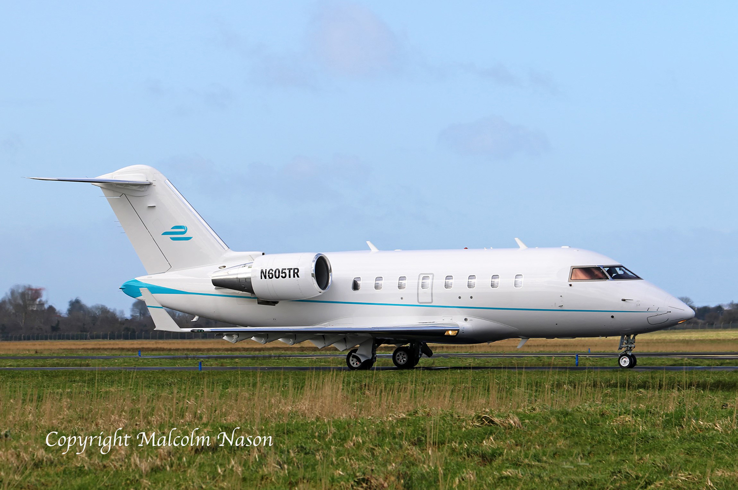
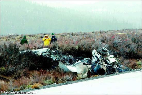
The captain and first officer (FO) departed on a non-revenue flight operating under instrument flight rules with four passengers bound for Truckee, California. Most of the flight was uneventful. During the descent, air traffic control (ATC) told the flight crew to expect the area navigation (RNAV [GPS]) approach for runway 20. The captain (pilot flying [PF]) stated and the FO (pilot monitoring [PM]) calculated and confirmed that runway 20 was too short for the landing distance required by the airplane at its expected landing weight. Instead of making a request to ATC for the straight-in approach to runway 11 (the longer runway), the captain told the FO they could take the runway 20 approach and circle to land on runway 11, and the FO relayed this information to ATC. ATC approved, and the flight crew accepted the circle-to-land approach. Although the descent checklist required that the flight crew brief the new circle-to-land approach, and the flight crew’s acceptance of the new approach invalidated the previous straight-in approach brief, they failed to brief the new approach. ATC instructed the flight crew to hold, but the captain was slow in complying with this instruction, so the FO started the turn to enter the holding pattern and then informed ATC once they were established in the hold. About 20 seconds later, ATC cleared them for the approach. Before the FO confirmed the clearance, he asked the captain if he was ready for the approach, and the captain stated that he was. The FO subsequently commented that they had too much airspeed at the beginning of the approach and then suggested a 360° turn to the captain, but the captain never acknowledged the excessive airspeed and refused the 360° turn. After the FO visually identified the airport, he told the captain to make a 90° right turn to put the airplane on an approximate heading of 290°, which was parallel to runway 11 and consistent with the manufacturer’s operating manual procedures for the downwind leg of the circling approach. However, the FO instructed the captain to roll out of the turn prematurely, and the captain stopped the turn on a heading of about 233° magnetic, which placed the airplane at an angle 57° left of the downwind course parallel with runway 11. As a result of the early roll-out, the flight crew established a course that required an unnecessarily tight turning radius. When they started the turn to final, the airplane was still about 1.3 nautical miles (nm) from the maximum circling radius that was established for the airplane’s approach category. The FO also deployed flaps 45° after confirming with the captain (the manufacturer’s operating manual procedures for the downwind leg called for a flaps setting of 30°, but the manufacturer stated that a flight crew is not prohibited from a flaps 45° configuration if the approach remains within the limitations of the airplane’s flight manual). The airplane’s airspeed was 44 kts above the landing reference speed (Vref) of 118 kts that the flight crew had calculated earlier in the flight; the FO told the captain, “I’m gonna get your speed under control for you.” The FO likely reduced the throttles after he made this statement, as the engine fan speeds (N1) began to decrease from about 88% to about 28%, and the airplane began to slow from 162 kts. After the FO repeatedly attempted to point out the airport to the captain, the captain identified the runway; the captain's difficulty in finding the runway might have been the result of reduced visibility in the area due to smoke. The FO continuously reassured and instructed the captain throughout the circle-to-land portion of the approach. On the base leg to the runway and about 25 seconds before impact with the ground, the FO started to repeatedly ask for control of the airplane, but neither flight crewmember verbalized a positive transfer of control as required by the operator’s general operating manual (GOM); we could not determine who had control of the airplane following these requests. As the airplane crossed the runway extended centerline while maneuvering toward the runway, the FO noted that the airplane was too high. One of the pilots (recorded flight data did not indicate which) fully deployed the flight spoilers, likely to increase the airplane's sink rate. (The flight spoilers are deployed using a single control lever accessible to both pilots.) The airspeed at the time was 135 kts, 17 kts above the Vref based on the erroneous basic operating weight (BOW) programmed into the airplane’s flight management system (FMS). About 7 seconds later, the left bank became steeper, and the stall protection system (SPS) stick shaker and stick pusher engaged. The captain asked the FO, “What are you doing,” and the FO again asked the captain multiple times to “let [him] have the airplane.” The stick shaker and stick pusher then briefly disengaged before engaging again. The airplane then entered a rapid left roll, consistent with a left-wing stall, and impacted terrain. A postcrash fire consumed most of the wreckage. All six occupants, four passengers and two pilots, were killed.
Probable cause:
The first officer’s (FO’s) improper decision to attempt to salvage an unstabilized approach by executing a steep left turn to realign the airplane with the runway centerline, and the captain’s failure to intervene after recognizing the FO’s erroneous action, while both ignored stall protection system warnings, which resulted in a left-wing stall and an impact with terrain.
Contributing to the accident was
- The FO's improper deployment of the flight spoilers, which decreased the airplane's stall margin;
- The captain’s improper setup of the circling approach;
- The flight crew’s self-induced pressure to perform and
- Poor crew resource management which degraded their decision-making.
Final Report:

Crash of a Socata TBM-850 in Truckee

Date & Time: Dec 13, 2009 at 1738 LT
Type of aircraft:
Registration:
N850MT
Flight Type:
Survivors:
Yes
Schedule:
San Carlos – Truckee
MSN:
489
YOM:
2008
Crew on board:
1
Crew fatalities:
Pax on board:
1
Pax fatalities:
Other fatalities:
Total fatalities:
0
Captain / Total flying hours:
1738
Captain / Total hours on type:
1098.00
Aircraft flight hours:
196
Circumstances:
During the flight, the instrument-rated private pilot was monitoring the weather at his intended destination. He noted the weather and runway conditions and decided to conduct a global-positioning-system instrument approach to a known closed runway with the intention of circling to a different runway. As the airplane neared the missed approach point, the pilot established visual contact with the airport's runway environment and canceled his instrument flight rules clearance. As he entered the left downwind leg of the traffic pattern for his intended runway, the pilot noticed that the first part of the runway was covered in fog and that the visibility was 0.75 of a mile with light snow. With at least 5,000 feet of clear runway, he opted to land just beyond the fog. Prior to touchdown, the pilot concluded that there was not enough runway length left to make a landing and performed a go-around by applying power, pitching up, and retracting the landing gear. During the go-around, the pilot focused outside the airplane cockpit but had no horizon reference in the dark night conditions. He heard the stall warning and realized that the aircraft was not climbing. The pilot pitched the nose down and observed only snow and trees ahead. Not being able to climb over the trees, the airplane subsequently impacted trees and terrain, coming to rest upright in a wooded, snow-covered field. The pilot stated that there were no anomalies with the engine or airframe that would have precluded normal operation of the airplane.
Probable cause:
The pilot’s failure to maintain an adequate airspeed and clearance from terrain during an attempted go-around. Contributing to the accident was the pilot's decision to land on a partially obscured runway.
Final Report:

Crash of a Learjet 35A in Truckee: 2 killed

Date & Time: Dec 28, 2005 at 1406 LT
Type of aircraft:
Operator:
Registration:
N781RS
Flight Type:
Survivors:
No
Schedule:
Twin Falls - Truckee - Carlsbad - Monterrey
MSN:
35-218
YOM:
1978
Crew on board:
2
Crew fatalities:
Pax on board:
0
Pax fatalities:
Other fatalities:
Total fatalities:
2
Captain / Total flying hours:
4880
Captain / Total hours on type:
2200.00
Copilot / Total flying hours:
1650
Copilot / Total hours on type:
56
Aircraft flight hours:
9244
Circumstances:
The airplane collided with the ground during a low altitude, steep banked, base-to-final left turn toward the landing runway during a circling instrument approach. The airplane impacted terrain 1/3-mile from the approach end of runway 28, and north of its extended centerline. A witness, located in the airport's administration building, made the following statement regarding his observations: "I saw the aircraft in and out of the clouds in a close base for [runway] 28. I then saw the aircraft emerge from a cloud in a base to final turn [and] it appeared to be approximately 300-400 feet above the ground. The left wing was down nearly 90 degrees. The aircraft appeared north of the [runway 28] centerline. The aircraft pitched nose down approximately 30-40 degrees and appeared to do a 1/2 cartwheel on the ground before exploding." ATC controllers had cleared the airplane to perform a GPS-A (circling) approach. The published weather minimums for category C and D airplanes at the 5,900-foot mean sea level airport was 3 miles visibility, and the minimum descent altitude was 8,200 feet mean sea level (msl). Airport weather observers noted that when the accident occurred, the visibility was between 1 1/2 and 5 miles. Scattered clouds existed at 1,200 feet above ground level (7,100 feet msl), a broken ceiling existed at 1,500 feet agl (7,400 feet msl) and an overcast condition existed at 2,400 feet agl (8,300 feet msl). During the approach, the first officer acknowledged to the controller that he had received the airport's weather. The airplane overflew the airport in a southerly direction, turned east, and entered a left downwind pattern toward runway 28. A 20- to 30-knot gusty surface wind existed from 220 degrees, and the pilot inadequately compensated for the wind during his base leg-to-final approach turning maneuver. The airplane was equipped with Digital Electronic Engine Controls (DEEC) that recorded specific data bits relating to, for example, engine speed, power lever position and time. During the last 4 seconds of recorded data (flight), both of the power levers were positioned from a mid range point to apply takeoff power, and the engines responded accordingly. No evidence was found of any preimpact mechanical malfunction. The operator's flight training program emphasized that during approaches consideration of wind drift is essential, and a circling approach should not be attempted in marginal conditions.
Probable cause:
The pilot's inadequate compensation for the gusty crosswind condition and failure to maintain an adequate airspeed while maneuvering in a steep turn close to the ground.
Final Report:

Crash of a Beechcraft E90 King Air in Reno

Date & Time: Mar 13, 2002 at 1940 LT
Type of aircraft:
Operator:
Registration:
N948CC
Survivors:
Yes
Site:
Schedule:
Durango - Truckee
MSN:
LW-236
YOM:
1977
Crew on board:
1
Crew fatalities:
Pax on board:
5
Pax fatalities:
Other fatalities:
Total fatalities:
0
Captain / Total flying hours:
1610
Captain / Total hours on type:
608.00
Aircraft flight hours:
8773
Circumstances:
During an instrument approach, upon descending to the prescribed minimum descent altitude, about 1/2 mile from the missed approach point, the pilot failed to maintain flying airspeed. The airplane stalled, rolled left, and in an uncontrolled descent collided with a commercial building 0.96 nm from the runway's displaced threshold. The accident occurred during the return portion of a round trip flight, while on final approach to the pilot's alternate airport due to a weather-induced diversion. Moderate intensity snow showers and freezing fog existed. During the initial approach, the reported visibility was 1 1/2 miles. About the time the pilot passed the final approach fix, the visibility decreased to 1/2 mile, but the pilot was not informed of the decrease below his 1-mile minimum requirement. The pilot had maintained the recommended 140-knot approach speed in the icing conditions until about 3 1/2 miles from the runway. Thereafter, the airplane's speed gradually decreased until reaching about 75 knots. After the airplane started vibrating, the pilot increased engine power, but his action was not timely enough to avert stalling. Company mechanics maintained the airplane. On previous occasions overheat conditions had occurred wherein the environmental ducting melted and heat was conducted to the adjacent pneumatic tube that provides deice air to the empennage boots. During the accident investigation, the deice tube was found completely melted closed, thus rendering all of the empennage deice boots dysfunctional.
Probable cause:
The pilot's inadequate approach airspeed for the existing adverse meteorological conditions followed by his delayed remedial action to avert stalling and subsequent loss of airplane control. Contributing factors were the pilot's reduced visibility due to the inclement weather and the icing conditions.
Final Report:

Crash of a Socata TBM-700 in Truckee

Date & Time: Mar 13, 1998 at 1900 LT
Type of aircraft:
Operator:
Registration:
N345RD
Flight Type:
Survivors:
Yes
Schedule:
Novato - Truckee
MSN:
076
YOM:
1993
Crew on board:
1
Crew fatalities:
Pax on board:
3
Pax fatalities:
Other fatalities:
Total fatalities:
0
Captain / Total flying hours:
2088
Captain / Total hours on type:
1200.00
Aircraft flight hours:
1119
Circumstances:
The pilot was cleared for a GPS approach. He stated that he was too high to make a good landing, so he opted for a circling approach to another runway. As he turned for the base leg, he lost visual contact and became disoriented. It was a dark night with no moon. The pilot realized that he was in a 70- to 80-degree left bank and returned the airplane to a level attitude, then noticed the ground directly in front of him. The aircraft ran through a barbed wire fence, collided with trees, and slid rearward to a stop in a high altitude meadow east of the airport. The FAA completed an evaluation of the circling approach procedures and night operations for that airport and did not find any problems.
Probable cause:
The failure of the pilot to maintain control of the aircraft due to spatial disorientation. A factor was the dark night.
Final Report:

Crash of a Cessna 414 Chancellor in Truckee: 4 killed

Date & Time: Feb 10, 1993 at 0815 LT
Type of aircraft:
Operator:
Registration:
N711LT
Flight Phase:
Flight Type:
Survivors:
No
Schedule:
Truckee - Farmington
MSN:
414-0630
YOM:
1975
Crew on board:
1
Crew fatalities:
Pax on board:
3
Pax fatalities:
Other fatalities:
Total fatalities:
4
Captain / Total flying hours:
387
Circumstances:
A Cessna 414 collided with a tree in a mountainous residential area about 1 mile from the airport. Instrument meteorological conditions with 1/8 mile visibility prevailed and an instrument flight rules (IFR) flight plan was filed, but was not opened. The airplane departed under visual flight rules. The elevation of the collision was about 100 feet higher than the airport. The standard instrument departure procedures for the airport prescribe takeoff minimums of 3,500 foot ceiling and 3 miles visibility. The procedure requires a minimum climb rate of 425 feet per nautical mile, a right turn after takeoff to intercept a 002° radial off a VOR, and a climb to a specified altitude. The airman's information manual recommends that pilots climb to 400 feet agl before turning when executing standard instrument departure under IFR. The airplane was also determined to be about 400 pounds over maximum gross weight at the time of the takeoff. The wreckage examination disclosed no evidence of any pre existing aircraft or engine malfunctions or failures. All four occupants were killed.
Probable cause:
The decision of the pilot not to follow instrument flight rule procedures during instrument meteorological conditions and poor preflight planning which resulted in operation of the airplane over the maximum gross weight and reduced performance. Factors in the accident were the foggy weather conditions, and high terrain.
Final Report:

Crash of a Cessna 411 in Chilcoot: 4 killed

Date & Time: Mar 3, 1978 at 1940 LT
Type of aircraft:
Registration:
N3212R
Flight Phase:
Flight Type:
Survivors:
No
Schedule:
San Jose - Truckee
MSN:
411-0212
YOM:
1966
Crew on board:
1
Crew fatalities:
Pax on board:
3
Pax fatalities:
Other fatalities:
Total fatalities:
4
Captain / Total flying hours:
151
Captain / Total hours on type:
69.00
Circumstances:
While flying in poor weather conditions, the pilot lost control of the airplane that entered an uncontrolled descent and crashed in flames in an uninhabited area located in the region of Chilcoot. The aircraft was destroyed and all four occupants were killed.
Probable cause:
Uncontrolled descent and subsequent uncontrolled collision with ground after the pilot initiated flight in adverse weather conditions and suffered a spatial disorientation. The following contributing factors were reported:
- Low ceiling,
- IFR flight conditions,
- VFR flight not recommended.
Final Report:

Crash of a Lockheed 18-56 LodeStar in Truckee

Date & Time: Feb 21, 1977 at 1620 LT
Type of aircraft:
Operator:
Registration:
N100GP
Flight Phase:
Survivors:
Yes
MSN:
2571
YOM:
1943
Crew on board:
2
Crew fatalities:
Pax on board:
0
Pax fatalities:
Other fatalities:
Total fatalities:
0
Captain / Total flying hours:
7191
Captain / Total hours on type:
15.00
Circumstances:
Just after liftoff, while in initial climb, the twin engine airplane encountered difficulties to gain height. It stall, struck the ground and crashed in flames. Both occupants were injured while the aircraft was destroyed.
Probable cause:
Stall during initial climb due to inadequate preflight preparation on part of the crew. The following contributing factors were reported:
- Failed to maintain flying speed,
- Airframe ince,
- 12 inches spanwise ice strip on upper wing surface.
Final Report:

Crash of a Douglas C-47B-10-DK near Truckee: 4 killed

Date & Time: Oct 26, 1950
Operator:
Registration:
43-49030
Flight Phase:
Flight Type:
Survivors:
No
Schedule:
Ogden-Hill - McClellan
MSN:
14846/26291
YOM:
1944
Crew on board:
3
Crew fatalities:
Pax on board:
1
Pax fatalities:
Other fatalities:
Total fatalities:
4
Circumstances:
En route from Ogden-Hill AFB to McClellan AFB in Sacramento, the aircraft crashed in unknown circumstances in an isolated area located in the east part of California. As the aircraft failed to arrive at destination, SAR operations were conducted but eventually suspended few days later as no trace of the aircraft nor the crew was found. In May 1951, a rescue team taking part to the search of two fishermen discovered the wreckage of the airplane into the Lake Independence, about ten miles northwest of Truckee.