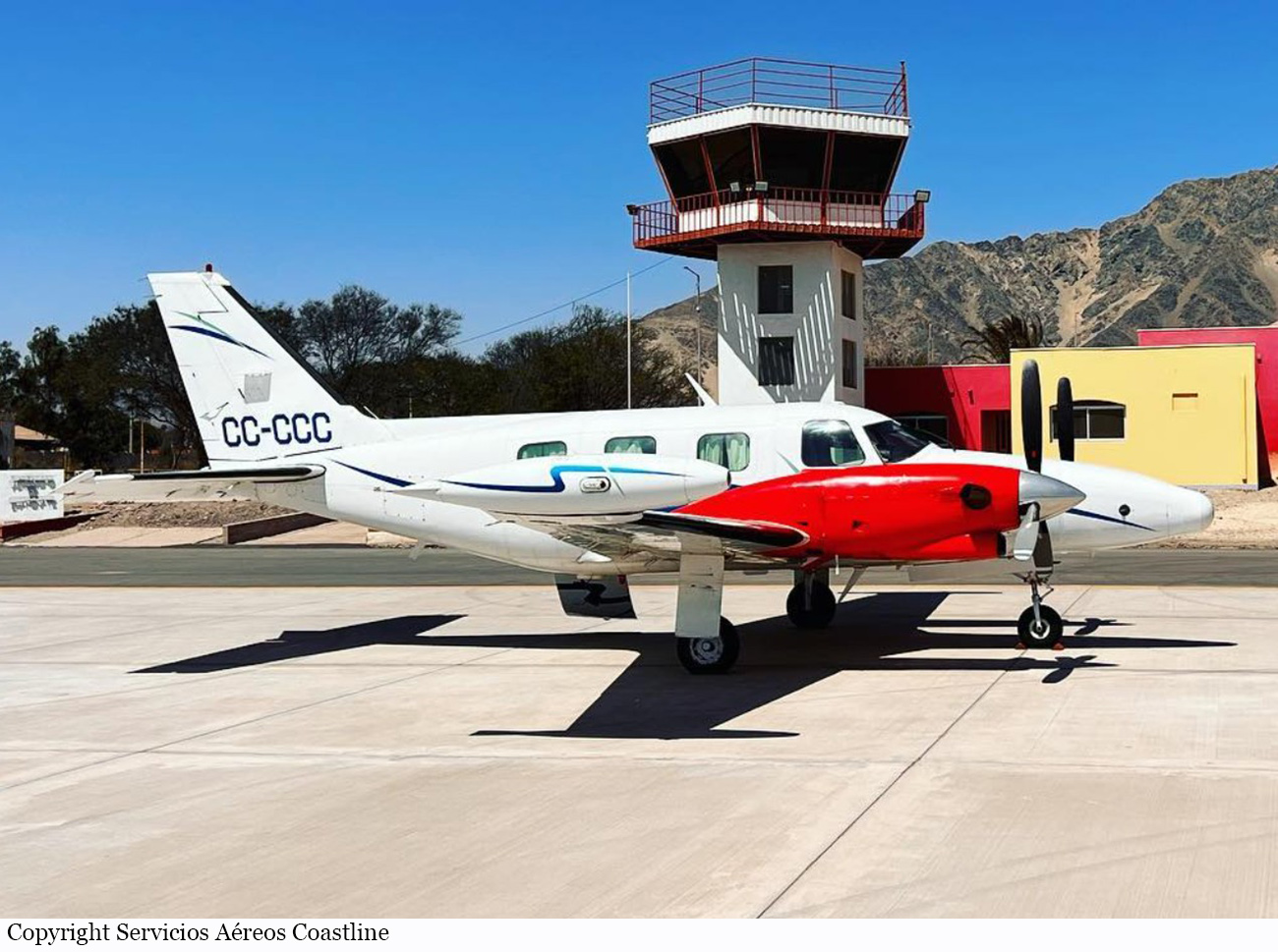
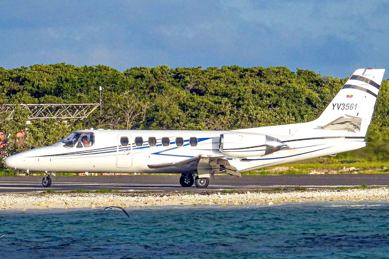
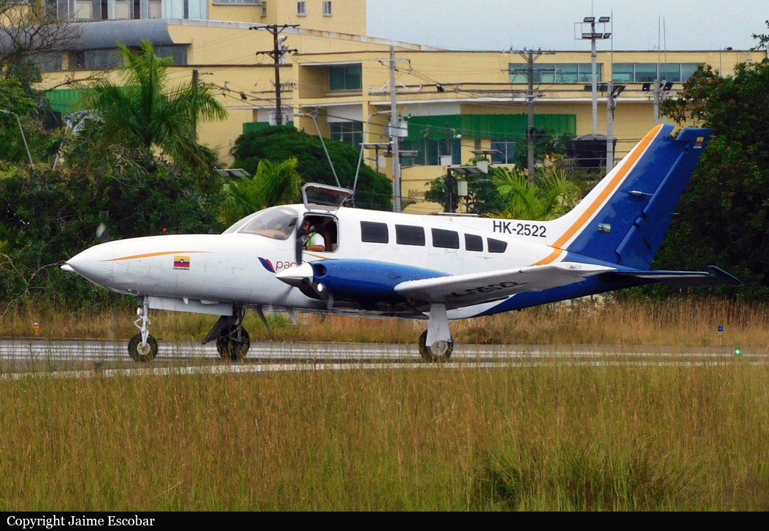
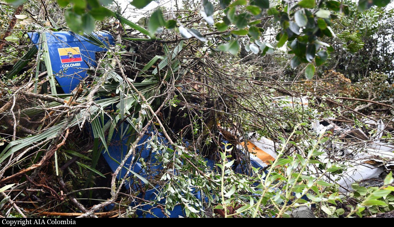
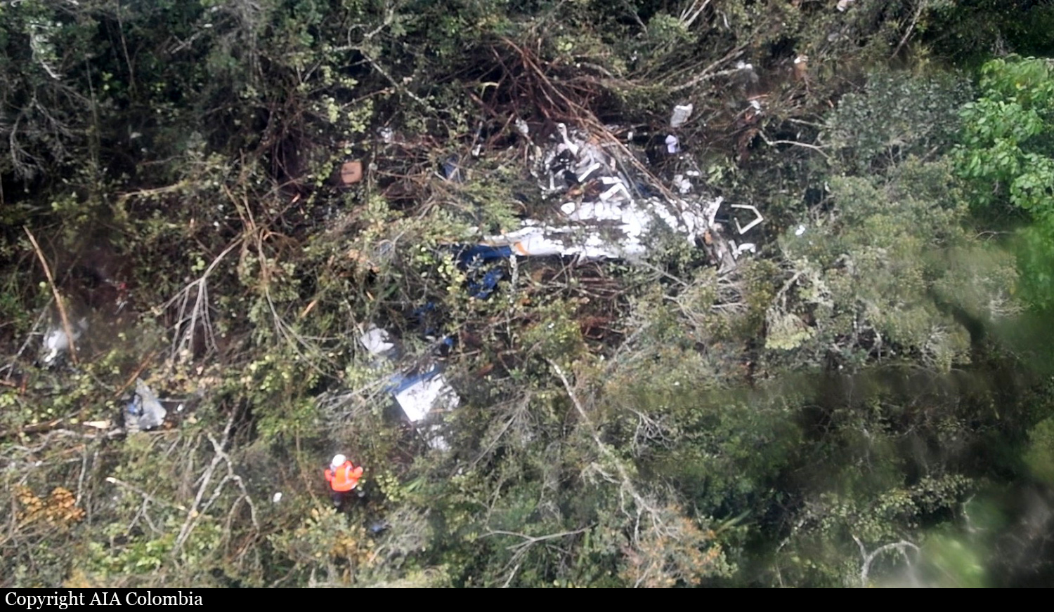
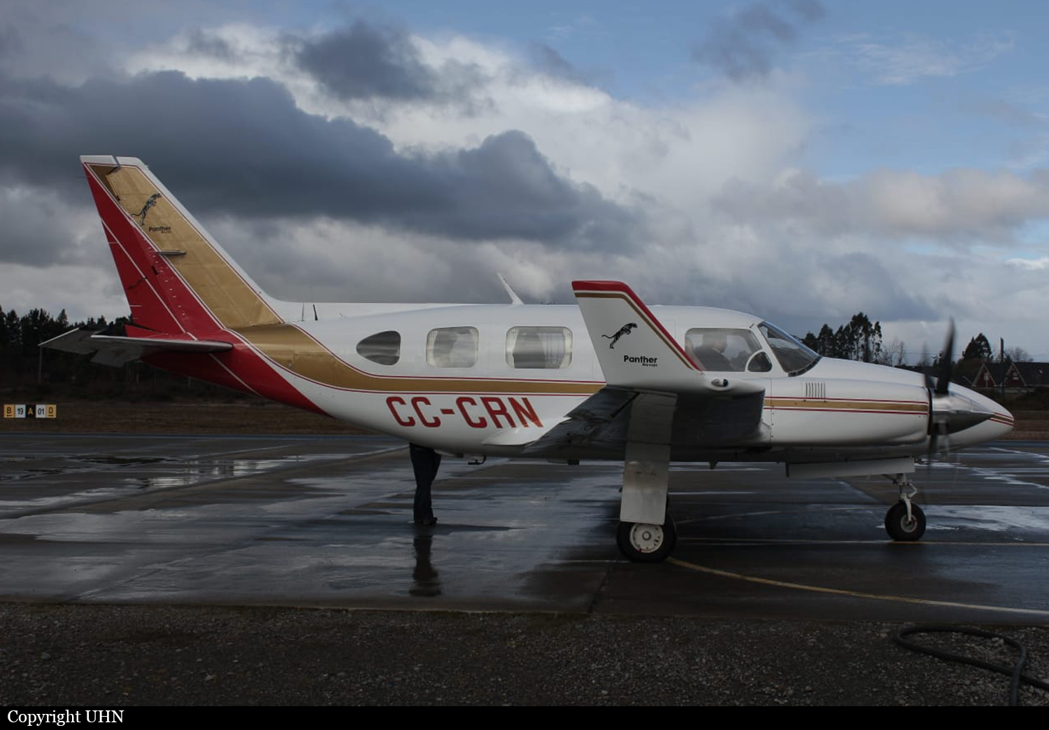
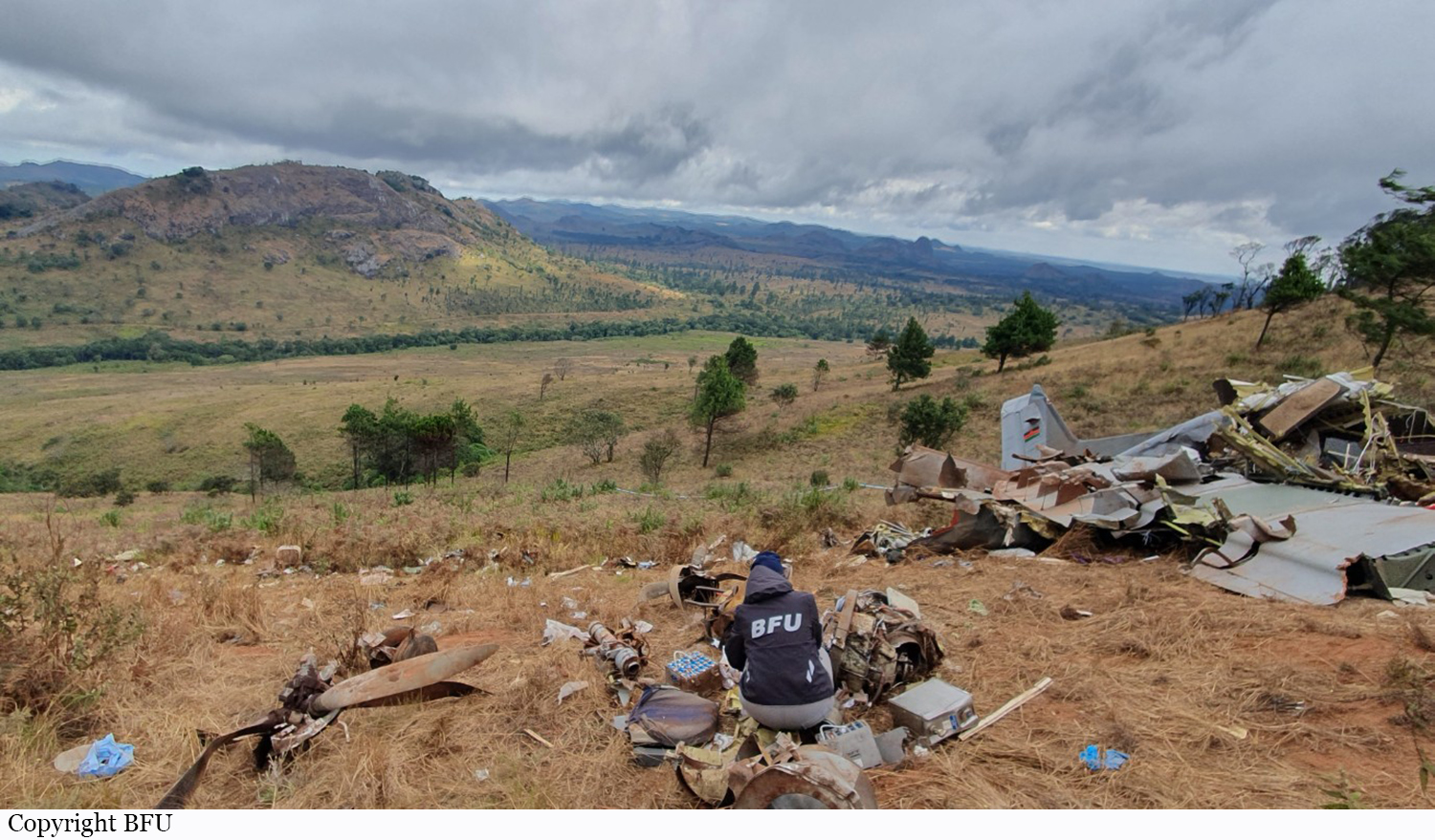
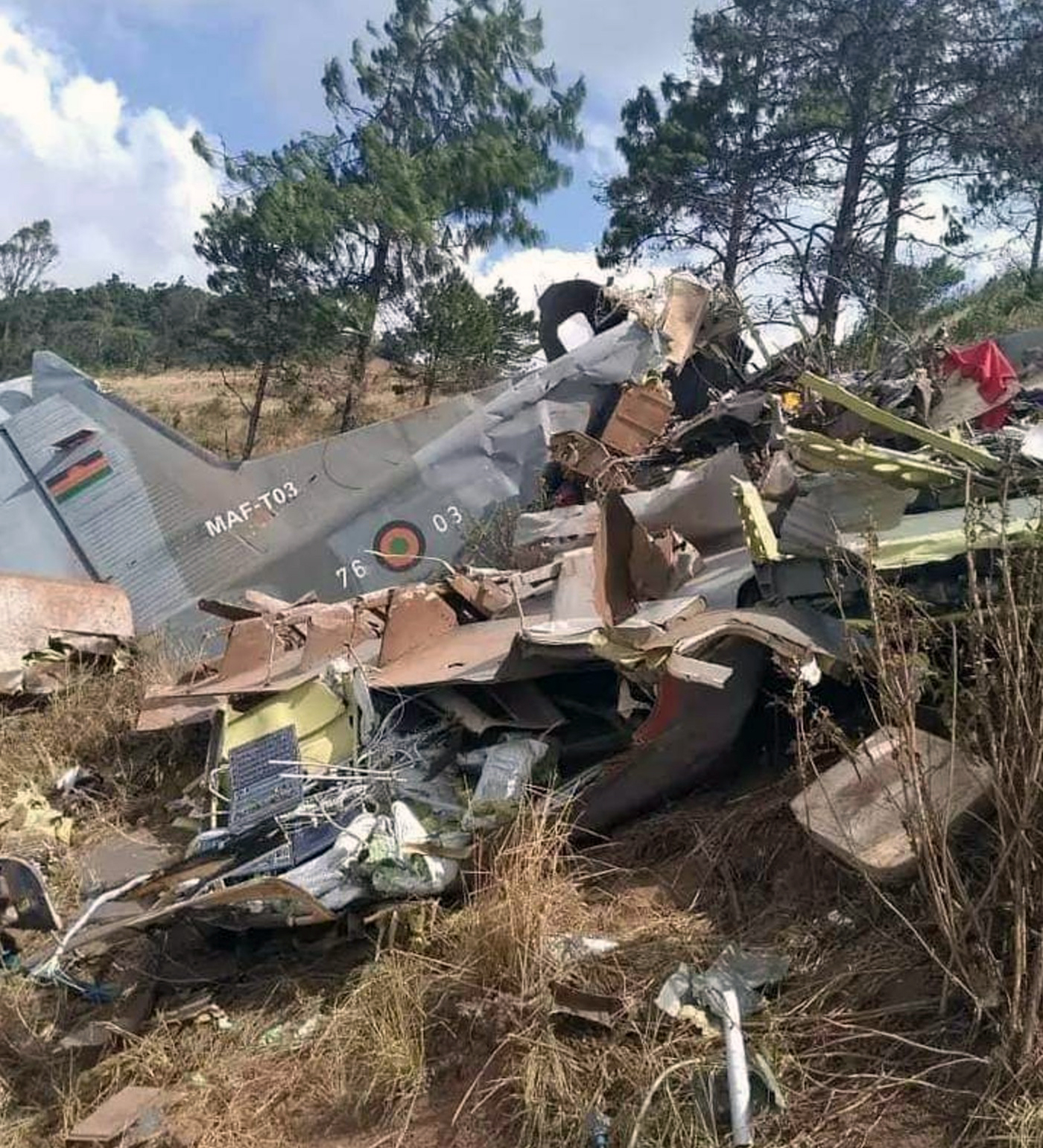
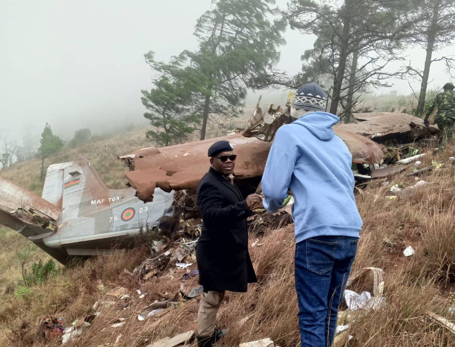
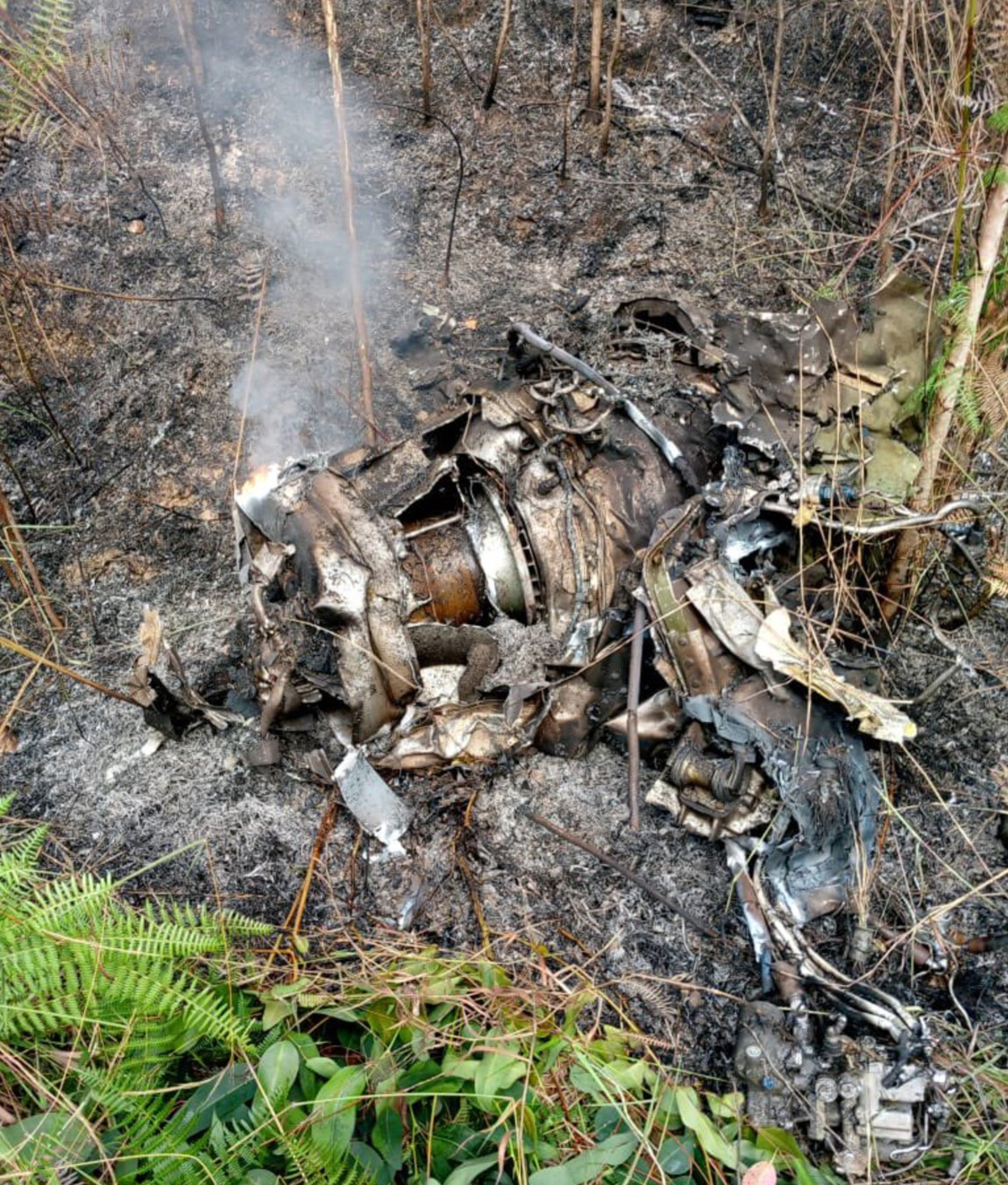
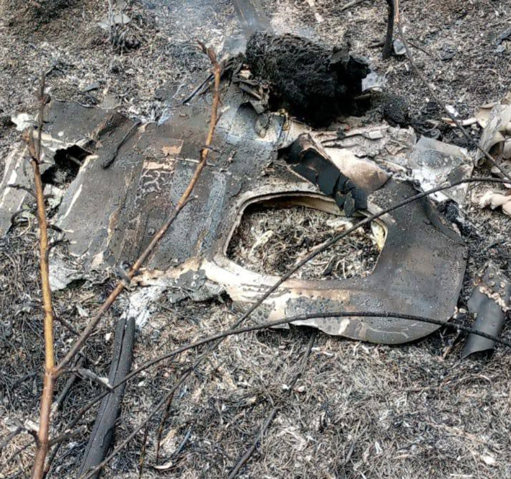
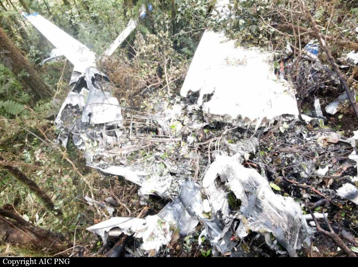
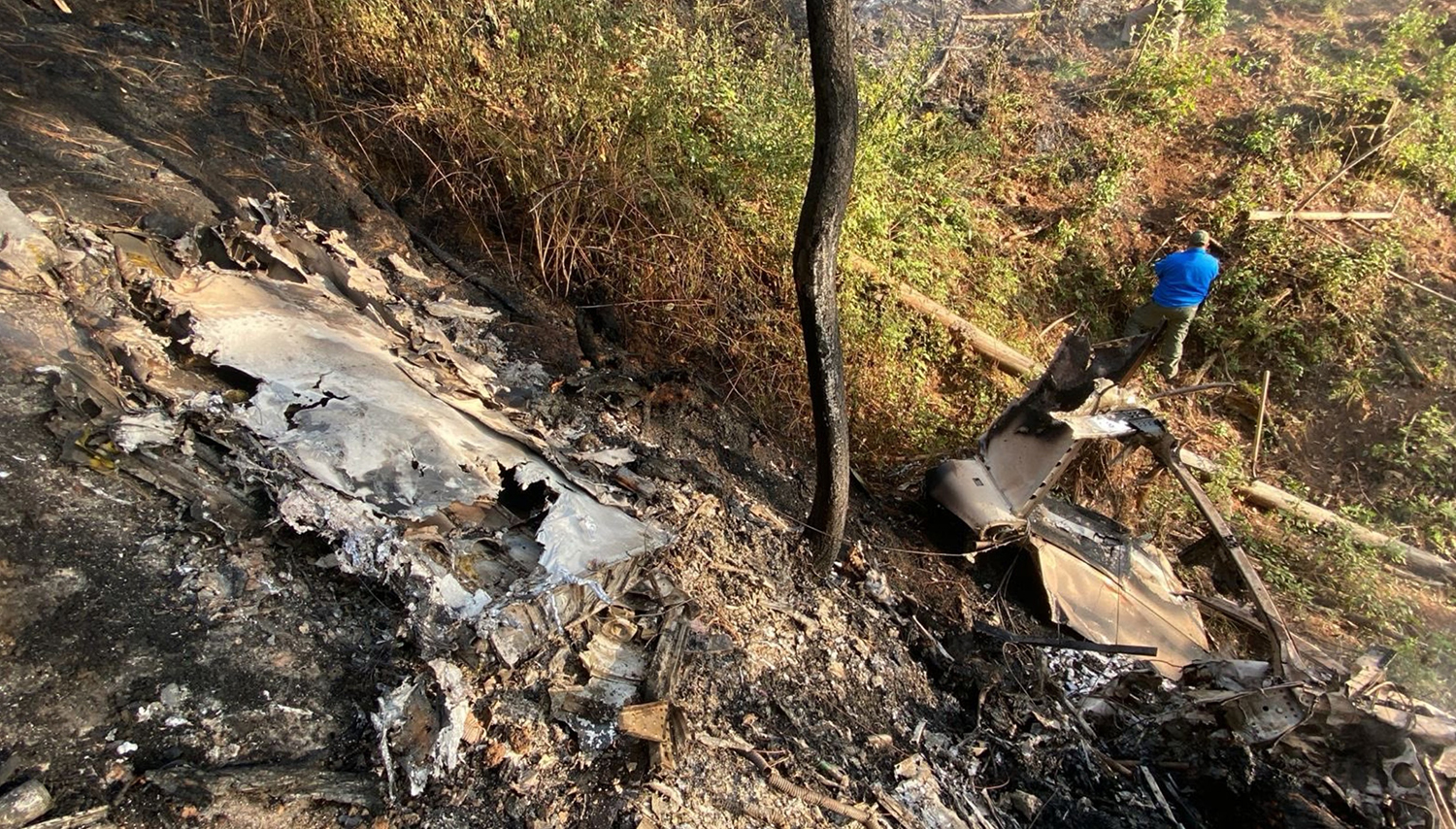
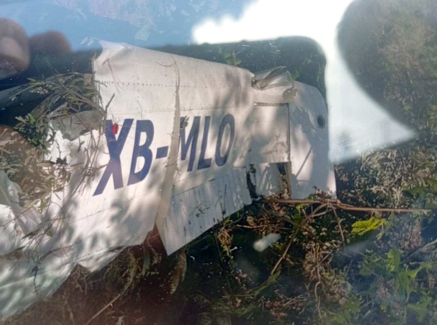
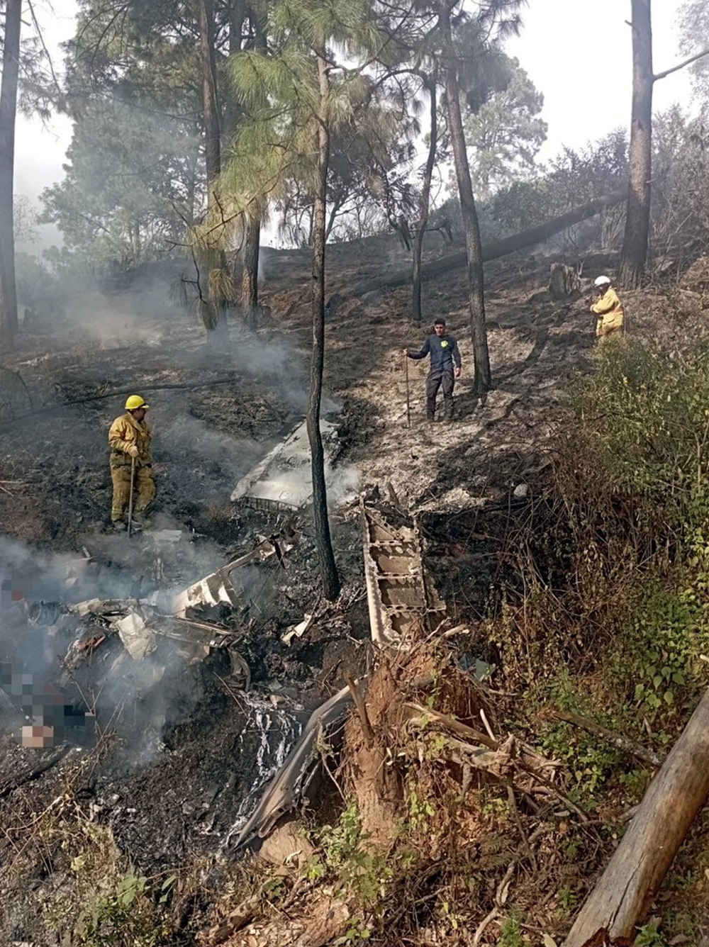
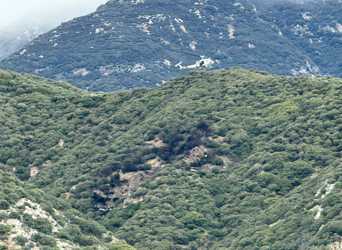
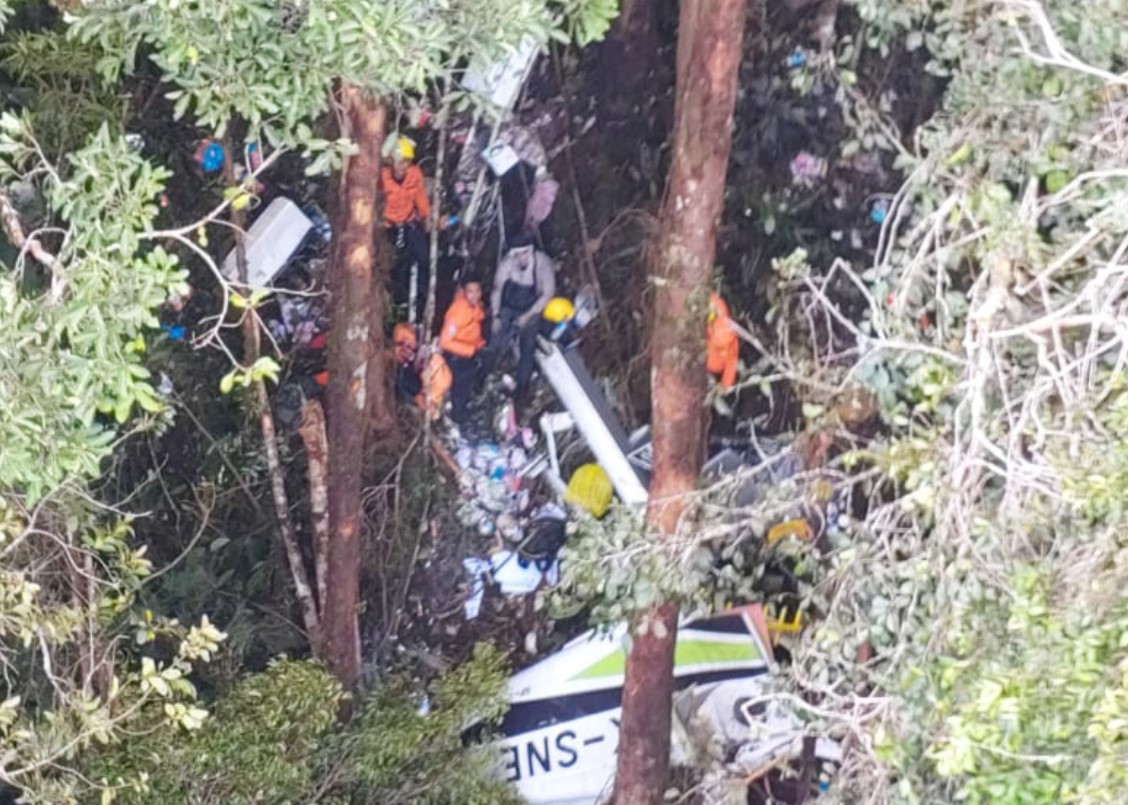
Crash of a Canadair CL-415 near Linguaglossa: 2 killed

Date & Time: Oct 27, 2022
Type of aircraft:
Operator:
Registration:
I-DPCN
Flight Phase:
Flight Type:
Survivors:
No
Site:
Schedule:
Lamezia Terme - Lamezia Terme
MSN:
2070
YOM:
2008
Country:
Region:
Crew on board:
2
Crew fatalities:
Pax on board:
0
Pax fatalities:
Other fatalities:
Total fatalities:
2
Circumstances:
The crew departed Lamezia Terme Airport on a fire fighting mission at the foot of the Etna Volcano, north of Catania. Approaching the area on fire, the crew initiated a right hand turn and while descending to rising terrain, the right wing tip impacted the ground, causing the aircraft to crash, bursting into flames. Both pilots were killed.

Crash of a Learjet 55C Longhorn near Charallave: 6 killed

Date & Time: Jun 22, 2022 at 1937 LT
Type of aircraft:
Operator:
Registration:
YV3304
Flight Type:
Survivors:
No
Site:
Schedule:
Puerto Cabello – Charallave
MSN:
55-145
YOM:
1990
Country:
Crew on board:
2
Crew fatalities:
Pax on board:
4
Pax fatalities:
Other fatalities:
Total fatalities:
6
Circumstances:
While approaching Charallave-Óscar Machado Zuloaga Airport, the crew encountered technical problems (apparently with the reversers) and declared an emergency. The captain initiated a go around procedure and completed a circuit south of the airport. During a second approach, the airplane deviated from the approach path to the south and continued until it impacted the top of a hill located 8 km south of the airport. The aircraft was destroyed by impact forces and a post crash fire and all six occupants were killed, among them Christian Toni, President of the Estudiantes de Mérida football club.

Crash of a De Havilland DHC-6 Twin Otter 300 near Sanosware: 22 killed

Date & Time: May 29, 2022 at 1010 LT
Operator:
Registration:
9N-AET
Flight Phase:
Survivors:
No
Site:
Schedule:
Pokhara – Jomsom
MSN:
619
YOM:
1979
Flight number:
TRA197
Country:
Region:
Crew on board:
3
Crew fatalities:
Pax on board:
19
Pax fatalities:
Other fatalities:
Total fatalities:
22
Captain / Total flying hours:
17500
Captain / Total hours on type:
13500.00
Copilot / Total flying hours:
520
Copilot / Total hours on type:
315
Aircraft flight hours:
41336
Aircraft flight cycles:
71338
Circumstances:
On 29 May 2022, Tara Air’s 9N-AET, Twin Otter (DHC-6/300) aircraft was scheduled for three flights on Pokhara-Jomsom-Pokhara sector. Tara Air had also filed flight plans for two additional Charter flights on the same sector. Among those five flights, four flights were to be conducted by a set of crews already positioned at Pokhara while the last flight was scheduled to be commanded by the PIC who had reached Pokhara from Kathmandu that very morning. Since Jomsom Airport was closed for operations due to bad weather, the PIC went to Tara Air crew camp and waited for the updates of weather improvement of Jomsom. After Jomsom Airport was open for operations at 0321 UTC, Tara Air operation decided to operate the first scheduled flight. However suspecting the next flight operation to Jomsom could not be operated, the original PIC assigned to the flight seated on board as a passenger to Jomsom for his scheduled business trip and the PIC assigned for the last flight took command. The Flight Plan was amended accordingly. At 0342 UTC, Summit Air’s 9N-AKZ, LET-410 took-off from Pokhara to Jomsom. At 0405 UTC, it reported an altitude of 12,500 ft and patches of cloud over Tatopani. At 0409 UTC, Summit Air’s second aircraft 9N-AMG, LET-410, took-off for Jomsom and subsequently, at 0410 UTC, 9N-AET of Tara Air (TRA197) took-off with 19 passengers and three crews on board. The Copilot had initially reported 3 crew and 18 passengers onboard to Pokhara Tower but later, revised the passenger figure was 19 prior to takeoff. 9N-AET was supposed to take-off before SMT 601 but the PIC seemed hesitant to commence the flight due to weather PIREP from 9N-AKZ that, the en-route weather was not favorable for VFR flights and critical around LETE and TATOPANI. All the crew members of TRA 197 and SMT 601 were in their respective cockpits and communicating with the preceding flight 9N-AKZ as well as with Pokhara tower for the updated information of en-route and destination weather. No flights had been conducted since morning and most of the passengers of Tara air and Summit Air were already at airport. In this situation it can be assumed that there was pressure to conduct flight from each angle. While listening to the CVR of TRA 197, it was observed that someone, either ground staff or some intimate passenger to the crew, advising strongly to the PIC to conduct the flight. Following the PIREP from 9NAKZ, both TRA197 and SMT 601 subsequently started their engines to commence the flights. The PIC of TRA 197 was still hesitant to conduct the flight for Jomsom even after the engine start and delayed the taxi as he was not yet convinced about the weather report received from preceding 9N-AKZ aircraft. In the meantime, SMT 601 lined up for departure to Jomsom. That was one of the most important pressure points to the PIC of TRA 197 to initiate departure. TRA 197 finally lined up and took off from Pokhara at 0410 UTC following the SMT 601 based on the en-route weather information (VMC) from 9N-AKZ, through Pokhara Tower. The en-route weather provided by Summit Air’s 9N-AKZ to Pokhara Tower and the crewmembers of TRA 197 and SMT 601 was not the same. Aircraft took off from Pokhara from runway 04 heading North. Tower instructed “report 5 DME northwest RW 04”. Then after departure at 90 climb power aircraft turned left to maintain a heading of 345 and planned to join heading 305 degree towards Ghodepani. After four minutes, TRA 197 reported, “Now on course…. 6000 climbing and ETA Jomsom 32” (0432 UTC). At 04:21 TRA 197 reported to Pokhara Tower as position approaching Ghodepani 12000 climbing for 12500. After 6 Seconds ATC Pokhara asked TRA 197, “confirm would like to change level and TRA 197 replied, “No Ma'am we have crossed Ghodepani and like to be on”. Pokhara Tower instructed, “Tara 197 contact Jomsom Tower 122.5” CVR recordings show that after TRA 197 crossed Ghodepani, the PIC was not comfortable with the en-route weather. However, the flight was continued following the advice of SMT 601. At 0426 UTC, TRA 197made the first contact with Jomsom AFS and reported its position to which Jomsom Tower conveyed the prevailing weather as “Wind South Westerly up to 30 kts, QNH 1019, Temp 18º”. The PIC of TRA 197 reconfirmed twice if the wind was maximum, up to 30 Kts and currently South Westerly-25kts. The crew was discussing about the bad weather being encountered and the PIC himself voiced his dissatisfaction about the behavior of other pilots who conduct VFR flights in such unfavorable weather. The CVR recordings reveal that the aircraft was encountering clouds and the PIC was trying his best to remain clear of the clouds. During the course of flight, TRA 197 hadn’t reported any abnormalities encountered and neither any technical defect on aircraft either to Jomsom tower or Pokhara Tower. As per CVR, PIC was searching for light and brighter areas and adamantly heading towards it. As per CVR and V2 tracker data, the aircraft was maintaining 12000 ft and was in a climbing attitude. During the continuous attempts of crew to avoid the clouds with Terrain Avoidance and Warning System [TAWS] inhibited, the aircraft met with an unfortunate CFIT accident into the rocky terrain at an altitude of 4050 meter AMSL at Sanusare Mountain, Thasang Rural Municipality, Mustang. As per V2 tracker, last position of 9N-AET was 7.7 nm SW of Jomsom Airport. The aircraft was completely destroyed by the impact and there were no survivors.
Probable cause:
The probable cause of this accident was the flight crew's failure to monitor and maintain the proper course while inadvertently flying in IMC conditions with the aircraft Terrain Avoidance and Warning System (TAWS) inhibited which resulted into a Controlled Flight Into Terrain (CFIT) accident.
The following contributing factors were identified:
1. The flight crew's failure to follow the SOP of company.
2. The aircraft flight operation with TAWS inhibited during deteriorating en-route weather condition.
3. Loss of situational awareness of crew.
4. Deteriorating en route weather.
5. Less experienced copilot for that sector and high crew gradient.
6. Poor CRM during the flight.
7. The whole cockpit duties [both PF and PM] were undertaken by the PlC, which likely impaired his performance.
8. Underutilization of the available Navigation instruments.
Final Report:

Crash of a Cessna 208 Caravan I on Mt Grüehorn: 1 killed

Date & Time: Mar 30, 2022 at 1222 LT
Type of aircraft:
Operator:
Registration:
D-FLIC
Flight Phase:
Flight Type:
Survivors:
No
Site:
Schedule:
Siegerland – Monte Argentario
MSN:
208-0274
YOM:
1998
Country:
Region:
Crew on board:
1
Crew fatalities:
Pax on board:
0
Pax fatalities:
Other fatalities:
Total fatalities:
1
Circumstances:
The pilot, sole on board, departed Siegerland Airport at 1100LT on a ferry flight to Monte Argentario, Tuscany. En route, while overflying Switzerland, he encountered marginal weather conditions. While cruising in IMC conditions, the single engine airplane impacted the slope of a rocky and snow covered face located west of Mt Grüehorn, in the south part of the canton of saint Gallen. The wreckage was found at an altitude of 1,700 metres. The aircraft disintegrated on impact and the pilot was killed.

Crash of a Boeing 737-89P near Wuzhou: 132 killed

Date & Time: Mar 21, 2022 at 1422 LT
Type of aircraft:
Operator:
Registration:
B-1791
Flight Phase:
Survivors:
No
Site:
Schedule:
Kunming - Guangzhou
MSN:
41474/5433
YOM:
2015
Flight number:
MU5735
Location:
Country:
Region:
Crew on board:
9
Crew fatalities:
Pax on board:
123
Pax fatalities:
Other fatalities:
Total fatalities:
132
Captain / Total flying hours:
6709
Copilot / Total flying hours:
31769
Aircraft flight hours:
18239
Aircraft flight cycles:
8986
Circumstances:
The airplane departed Kunming-Wujiaba Airport at 1315LT on a schedule service (flight MU5735) to Guangzhou, carrying 123 passengers and a crew of nine. At 1420LT, while cruising at an altitude of 29,100 feet, the aircraft entered an uncontrolled descent until 7,400 feet then climbed to 8,600 feet. It finally entered a steep descent and crashed almost two minutes later in a vertical attitude on hilly and wooded terrain located some 20 km southwest of Wuzhou. The airplane disintegrated on impact and all 132 occupants were killed. Two days after the accident, the CVR was found while the DFDR was found on March 27.

Crash of a Piper PA-46-500TP Malibu Meridian in Steamboat Springs: 1 killed

Date & Time: Dec 10, 2021 at 1809 LT
Operator:
Registration:
N744Z
Flight Type:
Survivors:
No
Site:
Schedule:
Cody – Steamboat Springs
MSN:
46-97134
YOM:
2002
Crew on board:
1
Crew fatalities:
Pax on board:
0
Pax fatalities:
Other fatalities:
Total fatalities:
1
Captain / Total flying hours:
581
Circumstances:
The pilot was conducting a solo night cross-country flight in low visibility through mountainous terrain. The pilot was then cleared by an air traffic controller to conduct a RNAV (GPS)-E instrument approach into the destination airport. After passing the final approach fix and before the missed approach point, the pilot, for an unknown reason, executed a left turn, consistent with the missed approach procedure. During the turn toward the holding waypoint, the airplane did not climb. Shortly thereafter, the airplane impacted steep rising terrain The local weather at the time of the accident indicated a cloud ceiling of 1,200 ft above ground level and 1 statute mile visibility, which was below the weather minimums for the approach. Data retrieved from the onboard avionics revealed that although the pilot flew the published route in accordance with the instrument approach procedure, the minimum required altitudes were not adhered to. A review of the ForeFlight weather briefing data indicated that a route weather briefing had been generated by the pilot with the filing of the instrument flight rules (IFR) flight plan. While no weather imagery was reviewed during the period, the pilot had checked METARs for the destination and another nearby airport before departure and viewed the RNAV (GPS)-E approach procedure at the destination airport. A review of the data that was presented to the pilot indicated that visual flight rules conditions prevailed at the destination with light snow in the vicinity at the time it was generated. Based on the preflight weather briefing the pilot obtained, he was likely unaware of the IFR conditions and below minimum weather conditions at the destination until he descended into the area and obtained the current local weather during the flight. It is probable that, based upon the weather and flight track information, as the pilot was on the instrument approach, he became aware of the below minimum weather conditions and elected to initiate the missed approach, as evident by the turn away from the airport similar to the missed approach procedure and the flaps and landing gear being in transition. This investigation was unable to determine why the missed approach procedure was prematurely initiated and why the airplane failed to climb. Additionally, there were no preimpact mechanical malfunctions or anomalies found during a postaccident examination that would have precluded normal operation.
Probable cause:
The pilot’s failure to adhere to the published instrument approach procedure, which resulted in controlled flight into terrain.
Final Report:

Crash of an Antonov AN-26KPA near Khabarovsk: 6 killed

Date & Time: Sep 22, 2021
Type of aircraft:
Operator:
Registration:
RA-26673
Flight Phase:
Flight Type:
Survivors:
No
Site:
MSN:
84 08
YOM:
1979
Country:
Region:
Crew on board:
6
Crew fatalities:
Pax on board:
0
Pax fatalities:
Other fatalities:
Total fatalities:
6
Circumstances:
The aircraft was completing an aerial work mission (calibration), carrying six crew members. En route, the aircraft impacted trees and crashed in a wooded area located on the slope of Mt Khrebtovaya located in the Bolchoï Khekhtsir Mountain Range. The wreckage was found a day later at an altitude of 786 metres and some 38-40 km southwest from the Khabarovsk-Novy Airport. The aircraft was totally destroyed by impact forces and all six occupants were killed. At the time of the accident, the visibility was reduced to 2 km due to low clouds.

Crash of a De Havilland DHC-6 Twin Otter 300 in Bilogai: 3 killed

Date & Time: Sep 15, 2021 at 0730 LT
Operator:
Registration:
PK-OTW
Flight Type:
Survivors:
No
Site:
Schedule:
Nabire – Bilogai
MSN:
493
YOM:
1976
Country:
Region:
Crew on board:
3
Crew fatalities:
Pax on board:
0
Pax fatalities:
Other fatalities:
Total fatalities:
3
Captain / Total flying hours:
13158
Captain / Total hours on type:
8051.00
Copilot / Total flying hours:
974
Copilot / Total hours on type:
807
Aircraft flight hours:
10333
Aircraft flight cycles:
1569
Circumstances:
On 15 September 2021, a DHC-6-300 (Twin Otter) aircraft registered PK-OTW was being operated for an unscheduled cargo flight from Douw Aturure Airport (WABI), Nabire, Papua to Bilorai Airport (WAYB), Intan Jaya, Papua. The aircraft was operated by two pilots accompanied by one engineer on board. The filed flight plan for the flight indicated that the aircraft would be operated under Visual Flight Rule (VFR) with fuel endurance of 2 hours 30 minutes. The estimate time departure for the flight was at 0640 LT. At 0610 LT, the pilot received weather observation report from the Bilorai aeronautical communication officer (ACO) that the visibility was 5 up to 7 kilometers, several clouds over the airport and all final areas were clear. About 7 minutes later, the ACO updated the observation report which indicated that the visibility changed to 7 up to 8 kilometers (km). After the cargo loading process and the flight preparation had completed, the aircraft taxied to Runway 16. At 0644 LT, the aircraft departed and climbed to the cruising altitude of 9,500 feet. Prior to the departure, there was no record or report of aircraft system malfunction. The Pilot in Command (PIC) acted as Pilot Monitoring (PM) while the Second in Command (SIC) acted as Pilot Flying (PF). At 0658 LT, the PK-OTW pilot reported to the Nabire air traffic control that the aircraft was at 25 Nm with altitude of 9,500 feet. At 0702 LT, the SIC asked the PIC to have the aircraft control as PF. During flight, the PK-OTW pilots monitored weather information provided by the pilots of two other aircraft that flew ahead of the PK-OTW to Bilorai. Both pilots monitored that the first aircraft (Cessna 208B EX) landed using Runway 27 while the second aircraft (Cessna 208B) would use Runway 09. At 0715 LT, the PIC advised the SIC to use the Runway 27 for landing. At 0719 LT, the SIC made initial contact with the ACO and advised that the aircraft was approaching Bilai at altitude of 9,500 feet and the estimate time arrival at Bilorai was 0726 LT. The ACO acknowledged the pilot report and provided current weather observation as follows “…wind westerly 3 until 5 knots, final 09 open with broken fog and final 27 open, visibility 5 until 7 km, blue sky overhead”. The SIC acknowledged the weather information and advised the ACO would report when the aircraft position was on left downwind Runway 27. At 0721 LT, the SIC read the descent checklist included the item of Landing Data/Approach Briefing and was replied by completed. The Cockpit Voice Recorder (CVR) did not record any pilot’s discussion regarding to the airport minimum safe altitude since the beginning of the recording. At 0723 LT, a pilot of DHC-6-400 aircraft registered PK-OTJ, asked the PK-OTW pilot of the weather condition in Bilorai. The PK-OTJ flew behind the PK-OTW with from Nabire to Bilorai. The SIC then responded that the PK-OTW was on descend and would fly through clouds about 5 Nm to Bilorai. Thereafter, the ACO provided traffic information to PK-OTW pilot that there was an aircraft (Cessna 208B aircraft) on final Runway 09. The PIC who acted as PF acknowledged the traffic information and advised to the ACO that the PK-OTW would join left downwind Runway 27 for the landing approach. At 0725 LT, the SIC advised to the ACO that the aircraft was on left downwind Runway 27. The ACO then advised the PK-OTW pilot to report when on final Runway 27. At 07:26:12 LT, a stall warning recorded in the Cockpit Voice Recorder (CVR) then the PIC asked to the SIC to check the aircraft speed. The SIC responded the aircraft speed was 65 knots. At 07:26:16 LT, the PIC asked to the SIC to advise the ACO that they were making a go around. The SIC then advised the ACO that the PK-OTW was making a go around and was responded to report when on final. The CVR did not record pilot’s discussion about the plan maneuver of the go around. At 07:26:45 LT, the PIC informed that they were making a go around to the PK-OTJ pilot. The PK-OTJ pilot responded that the aircraft was approaching Homeyo and would reduce the speed to make enough separation with the PK-OTW. The PIC then advised the PK-OTJ that the PK-OTW would attempt to land using Runway 09. Based on the data transmitted from the flight following system, at 07:27:57 LT, the aircraft was about 3 Nm outbound from Bilorai on direction of 238°. At 07:28:22 LT, the PK-OTJ pilot advised to the ACO that the aircraft was about 6 nm to Bilai and the pilot intended to make holding maneuver over Bilai to make enough separation with the PK-OTW. At 07:28:33 LT, the SIC advised the PIC that the aircraft was at 8,200 feet and was responded that the PIC initiated turning the aircraft. A few second later, the SIC advised to the PIC that the aircraft was turning, and the aircraft was at 3.2 Nm outbound from Bilorai. At 07:28:38 LT, the last data of the flight following system recorded that the aircraft was on direction of 110°. At 07:29:25 LT, the SIC advised the PIC to fly left. Thereafter, the SIC advised the PIC that the aircraft was passing 8,000 feet. At 07:29:35 LTC, the PIC asked to the SIC about the distance to Bilorai and was responded 2.5 Nm. The SIC, reminded the PIC to fly left as the aircraft flew too close to the terrain. At 07:29:49 LT, the CVR recorded the first impact sound and the CVR recording stopped at 07:29:55 LT. At 0730 LT, the ACO asked the PK-OTW pilot intention as the aircraft was not visible from the ACO working position, and the pilot did not respond the ACO. At about the same time, the ACO heard impact sound that was predicted coming from terrain area on west of Bilorai. The ACO then called the PK-OTW pilot several times without response. Several pilots also attempted to contact the PK-OTW with the same result. The PK-OTW was found on a ridge at elevation of 8,100 feet, about 2 Nm on bearing 260° from Bilorai.

Crash of a Beriev Be-200Chs near Kahramanmaraş: 8 killed

Date & Time: Aug 14, 2021
Type of aircraft:
Operator:
Registration:
RF-88450
Flight Phase:
Flight Type:
Survivors:
No
Site:
MSN:
64620090311
YOM:
2020
Country:
Region:
Crew on board:
8
Crew fatalities:
Pax on board:
0
Pax fatalities:
Other fatalities:
Total fatalities:
8
Circumstances:
Owned and operated by the Russian Navy, the aircraft was dispatched in Turkey in July to help the Turkish government (General Directorate of Forestry) to fight raging forest fires in the southeast part of the country. On board were eight crew members, five Russian and three Turkish. After the aircraft drop water on fire, the crew elected to gain height when the aircraft impacted terrain and crashed on the slope of a mountain, bursting into flames. The aircraft was totally destroyed and all 8 occupants were killed.

Crash of a De Havilland DHC-2 Beaver near Ketchikan: 6 killed

Date & Time: Aug 5, 2021 at 1050 LT
Type of aircraft:
Operator:
Registration:
N1249K
Flight Phase:
Survivors:
No
Site:
Schedule:
Ketchikan - Ketchikan
MSN:
1594
YOM:
1965
Crew on board:
1
Crew fatalities:
Pax on board:
5
Pax fatalities:
Other fatalities:
Total fatalities:
6
Captain / Total flying hours:
15552
Captain / Total hours on type:
8000.00
Aircraft flight hours:
15028
Circumstances:
The accident flight was the pilot’s second passenger sightseeing flight of the day that overflew remote inland fjords, coastal waterways, and mountainous, tree-covered terrain in the Misty Fjords National Monument. Limited information was available about the airplane’s flight track due to radar limitations, and the flight tracking information from the airplane only provided data in 1-minute intervals. The data indicated that the airplane was on the return leg of the flight and in the final minutes of flight, the pilot was flying on the right side of a valley. The airplane impacted mountainous terrain at 1,750 ft mean sea level (msl), about 250 ft below the summit. Examination of the wreckage revealed no evidence of pre accident failures or malfunctions that would have precluded normal operation. Damage to the propeller indicated that it was rotating and under power at the time of the accident. The orientation and distribution of the wreckage indicated that the airplane impacted a tree in a left-wing-low attitude, likely as the pilot was attempting to maneuver away from terrain. Review of weather information for the day of the accident revealed a conditionally unstable environment below 6,000 ft msl, which led to rain organizing in bands of shower activity. Satellite imagery depicted that one of these bands was moving northeastward across the accident site at the accident time. Federal Aviation Administration (FAA) weather cameras and local weather observations also indicated that lower visibility and mountain obscuration conditions were progressing northward across the accident area with time. Based on photographs recovered from passenger cell phones along with FAA weather camera imagery, the accident flight encountered mountain obscuration conditions, rain shower activity, and reduced visibilities and cloud ceilings, resulting in instrument meteorological conditions (IMC) before the impact with terrain. The pilot reviewed weather conditions before the first flight of the day; however, there was no indication that he obtained updated weather conditions or additional weather information before departing on the accident flight. Based on interviews, the accident pilot landed following the first flight of the day in lowering visibility, ceiling, and precipitation, and departed on the accident flight in precipitation, based on passenger photos. Therefore, the pilot had knowledge of the weather conditions that he could have encountered along the route of flight before departure. The operator had adequate policies and procedures in place for pilots regarding inadvertent encounters with IMC; however, the pilot’s training records indicated that he was signed off for cue-based training that did not occur. Cue-based training is intended to help calibrate pilots’ weather assessment and foster an ability to accurately assess and respond appropriately to cues associated with deteriorating weather. Had the pilot completed the training, it might have helped improve his decision-making skills to either cancel the flight before departure or turn around earlier in the flight. The operator’s lack of safety management protocols resulted in the pilot not receiving the required cue-based training, allowed him to continue operating air tours with minimal remedial training following a previous accident, and allowed the accident airplane to operate without a valid FAA registration. The operator was signatory to a voluntary local air tour operator’s group letter of agreement that was developed to improve the overall safety of flight operations in the area of the Misty Fjords National Monument. Participation was voluntary and not regulated by the FAA, and the investigation noted multiple instances in which the LOA policies were ignored, including on the accident flight. For example, the accident flight did not follow the standard Misty Fjords route outlined in the LOA nor did it comply with the recommended altitudes for flights into and out of the Misty Fjords. FAA inspectors providing oversight for the area reported that, when they addressed operators about disregarding the LOA, the operators would respond that the LOA was voluntary and that they did not need to follow the guidance. The FAA’s reliance on voluntary compliance initiatives in the local air tour industry failed to produce compliance with safety initiatives or to reduce accidents in the Ketchikan region.
Probable cause:
The pilot’s decision to continue visual flight rules (VFR) flight into instrument meteorological conditions (IMC), which resulted in controlled flight into terrain. Contributing to the accident was the FAA’s reliance on voluntary compliance with the Ketchikan Operator’s Letter of Agreement.
Final Report: