Crash of a Cessna 551 Citation II/SP off Ventspils: 4 killed

Date & Time: Sep 4, 2022 at 2044 LT
Type of aircraft:
Operator:
Registration:
OE-FGR
Flight Phase:
Flight Type:
Survivors:
No
Schedule:
Jerez - Cologne
MSN:
551-0021
YOM:
1979
Country:
Region:
Crew on board:
2
Crew fatalities:
Pax on board:
2
Pax fatalities:
Other fatalities:
Total fatalities:
4
Captain / Total flying hours:
1700
Captain / Total hours on type:
100.00
Aircraft flight hours:
8000
Circumstances:
The airplane departed Jerez-La Parra Airport at 1456LT on a flight to Cologne-Bonn Airport with four people on board. It continued at an assigned altitude of 36,000 feet until it entered the German Airspace. German ATC was unable to establish a radio contact with the crew so the decision was taken to send a Panavia Tornado of the Luftwaffe that departed Rostock-Laage AFB and intercepted the Cessna at 1815LT. The military pilot did not see any one in the cockpit and evacuated the area five minutes later. The airplane overflew Germany then entered the Swedish Airspace and continued bound to the northeast without significant change in heading, altitude or speed (365 knots). At 2028LT, the airplane started to descent and initiated a turn to the right three minutes later. At 2040LT, it entered an uncontrolled descent to the left and spiraled to the sea before crashing at 2044LT about 37 km northwest of Ventspils. Few debris and oil were found at the point of impact. The accident was not survivable.
Probable cause:
Cabin pressurization issue suspected.

Crash of a De Havilland DHC-3T Otter into the Mutiny Bay: 10 killed

Date & Time: Sep 4, 2022 at 1509 LT
Type of aircraft:
Operator:
Registration:
N725TH
Flight Phase:
Survivors:
No
Schedule:
Friday Harbor – Renton
MSN:
466
YOM:
1967
Crew on board:
1
Crew fatalities:
Pax on board:
9
Pax fatalities:
Other fatalities:
Total fatalities:
10
Captain / Total flying hours:
3686
Captain / Total hours on type:
1300.00
Aircraft flight hours:
24430
Circumstances:
On September 4, 2022, about 1509 Pacific daylight time, a float-equipped de Havilland DHC-3 (Otter), N725TH, was destroyed when it impacted the water in Mutiny Bay, near Freeland, Washington, and sank. The pilot and nine passengers were fatally injured. The airplane was owned by Northwest Seaplanes, Inc., and operated as a Title 14 Code of Federal Regulations (CFR) Part 135 scheduled passenger flight by West Isle Air dba Friday Harbor Seaplanes. The flight originated at Friday Harbor Seaplane Base (W33), Friday Harbor, Washington, with an intended destination of Will Rogers Wiley Post Memorial Seaplane Base (W36), Renton, Washington. Visual meteorological conditions prevailed at the time of the accident. The accident pilot was scheduled to fly the accident airplane on three multiple leg roundtrips on the day of the accident. The first roundtrip flight was uneventful; it departed from W36 about 0930, made four stops, and returned about 1215. The accident occurred during the pilot’s second trip of the day. A review of recorded automatic dependent surveillance–broadcast (ADS-B) data revealed that the second roundtrip departed 36 about 1253 and arrived at Lopez Seaplane Base, (W81), Lopez Island, Washington, about 1328.2 The data showed that the flight then departed W81 and landed at Roche Harbor Seaplane Base (W39) about 1356. The airplane departed W39 about 1432, arrived at W33 about 1438, and departed about 1450. According to ADS-B data, after the airplane departed W33, it flew a southerly heading before turning south-southeast. The en route altitude was between 600 and 1,000 ft above mean sea level (msl), and the groundspeed was between 115 and 135 knots. At 1508:40, the altitude was 1,000 ft msl, and the groundspeed had decreased to 111 knots. Based on performance calculations, at 1508:43, the airplane pitched up about 8° and then abruptly pitched down about 58°. The data ended at 1508:51, when the airplane’s altitude was 600 ft msl and the estimated descent rate was more than 9,500 ft per minute (the flightpath of the airplane is depicted in figure. Witnesses near the accident site reported, and security camera video confirmed, the airplane was in level flight before it entered a slight climb and then pitched down. One witness described the descent as “near vertical” and estimated the airplane was in an 85° nose-down attitude before impact with the water. Several witnesses described the airplane as “spinning,” “rotating,” or “spiraling” during portions of the steep descent. One witness reported hearing the engine/propeller and noted that he did not hear any “pitch change” in the sounds. The airplane continued in a nose-low, near-vertical descent until it impacted water in Mutiny Bay.
Probable cause:
It was determined that the probable cause of this accident was the in-flight unthreading of the clamp nut from the horizontal stabilizer trim actuator barrel due to a missing lock ring, which resulted in the horizontal stabilizer moving to an extreme trailing-edge-down position rendering the airplane’s pitch uncontrollable.
Final Report:

Crash of a Beechcraft C90A King Air in Gravestown

Date & Time: Sep 3, 2022 at 1021 LT
Type of aircraft:
Registration:
N342ER
Flight Phase:
Flight Type:
Survivors:
Yes
Schedule:
Tupelo - Tupelo
MSN:
LJ-1156
YOM:
1987
Crew on board:
1
Crew fatalities:
Pax on board:
0
Pax fatalities:
Other fatalities:
Total fatalities:
0
Captain / Total flying hours:
31
Circumstances:
The uncertificated pilot stole the accident airplane at Tupelo Airport with the intent of crashing it into a department store located 2 miles southeast of the airport. However, he continued to fly the airplane in the area for several hours until he performed an off-airport landing in a field 32 miles northwest of the departure airport that resulted in substantial damage to the airplane’s fuselage.
Probable cause:
The uncertificated pilot’s criminal act of stealing the airplane and later performing an off-airport landing that resulted in an impact with terrain.
Final Report:

Crash of a Cessna 207A Turbo Stationair 8 into Lake Powell: 2 killed

Date & Time: Aug 13, 2022 at 1619 LT
Operator:
Registration:
N9582M
Flight Phase:
Survivors:
Yes
Schedule:
Page - Page
MSN:
207-0705
YOM:
1981
Crew on board:
1
Crew fatalities:
Pax on board:
6
Pax fatalities:
Other fatalities:
Total fatalities:
2
Captain / Total flying hours:
550
Captain / Total hours on type:
35.00
Aircraft flight hours:
17307
Circumstances:
On August 13, 2022, about 1619 mountain standard time, a Cessna T207A airplane, N9582M, was substantially damaged when it was involved in an accident near Page, Arizona. The pilot received minor injuries, two passengers were fatally injured, two passengers were seriously injured, and one passenger received minor injuries. The airplane was operated as a Title 14 Code of Federal Regulations Part 91 air tour flight. According to witnesses, the accident airplane was the first airplane in a flight of 5 airplanes on a scenic tour of the Lake Powell area at a cruise altitude of about 1,000 ft to 2,000 ft above ground level. After nearly 30 minutes of flight and after making a turn back towards the airport, the accident pilot made a distress call and reported his engine lost power and he was ditching the airplane in Lake Powell. The airplane became submerged in the water and the two passengers who were fatally injured did not exit the airplane. National Park Service boats, several nearby private boats, and a few helicopters responded to the accident site, which was located about 13 miles northeast of the Page Municipal Airport, (PGA), Page, Arizona. The boats assisted the survivors in the water. Once aboard a boat that recovered the survivors, witnesses overheard the pilot on the phone discussing that he had experienced an engine failure. An underwater remote observation vehicle surveyed the accident site a couple of days after the accident. All major components of the airplane were observed, and the airplane came to rest upright at the lake bottom about 100 ft below the surface.
Probable cause:
The total loss of engine power for undetermined reasons during low altitude cruise flight, which resulted in a water ditching. Contributing to the severity of the accident was the pilot’s failure to extend the flaps during the ditching, which increased the impact forces to the occupants.
Final Report:

Crash of an Antonov AN-30M near Olenyok

Date & Time: Jun 22, 2022
Type of aircraft:
Operator:
Registration:
RA-30001
Flight Phase:
Flight Type:
Survivors:
Yes
Schedule:
Yakutsk - Olenek
MSN:
14 02
YOM:
1978
Flight number:
9424
Country:
Region:
Crew on board:
7
Crew fatalities:
Pax on board:
0
Pax fatalities:
Other fatalities:
Total fatalities:
0
Circumstances:
The twin engine airplane departed Yakutsk Airport on a cargo flight to Olenyok, carrying seven crew members and a load of 6,3 tons of food. En route, the airplane suffered a double engine failure. The crew reduced his altitude and attempted an emergency landing. The airplane crash landed in a wooded area located 70 km from Olenyok and came to rest. All seven crew members evacuated the cabin, among them three were slightly injured. The aircraft was damaged beyond repair.
Probable cause:
It is believed that the double engine failure is the consequence of a fuel exhaustion.

Crash of a PZL-Mielec AN-2R near Sebyan-Kyuyol: 2 killed

Date & Time: Jun 21, 2022 at 0830 LT
Type of aircraft:
Operator:
Registration:
RA-17742
Flight Phase:
Flight Type:
Survivors:
Yes
Schedule:
Us-Khatyn – Vertikal’nyy
MSN:
1G203-03
YOM:
1983
Country:
Region:
Crew on board:
2
Crew fatalities:
Pax on board:
1
Pax fatalities:
Other fatalities:
Total fatalities:
2
Captain / Total flying hours:
10700
Captain / Total hours on type:
10700.00
Copilot / Total flying hours:
1965
Copilot / Total hours on type:
1600
Circumstances:
The single engine airplane departed Us-Khatyn on a cargo flight to Vertikal'nyy, carrying one passenger and two pilots. En route, weather conditions worsened and the visibility was reduced due to fog. The airplane impacted tree tops and crashed on the slope of a wooded terrain located about 46 km southeast of the village of Sebyan-Kyuyol. As the airplane failed to arrive at destination (the flight was supposed to be 2 hours and 30 minutes), SAR operations were initiated. The wreckage was found 10 days later, on July 1st, in an uninhabited area. Both pilots were killed and the passenger was found alive after he found refuge in a fishing house where he could find food.
Probable cause:
Controlled flight into terrain after the crew continued to fly under VFR mode in IMC conditions.
The following contributing factors were identified:
- Unreasonable flight decision taken by the flight crew,
- The forecasted weather on the declared route did not ensure compliance with ATC,
- Failure of the pilot-in-command to take timely measures to return to the departure airfield or to take other actions to change the flight plan.
Final Report:

Crash of a De Havilland DHC-6 Twin Otter 300 near Sanosware: 22 killed

Date & Time: May 29, 2022 at 1010 LT
Operator:
Registration:
9N-AET
Flight Phase:
Survivors:
No
Site:
Schedule:
Pokhara – Jomsom
MSN:
619
YOM:
1979
Flight number:
TRA197
Country:
Region:
Crew on board:
3
Crew fatalities:
Pax on board:
19
Pax fatalities:
Other fatalities:
Total fatalities:
22
Captain / Total flying hours:
17500
Captain / Total hours on type:
13500.00
Copilot / Total flying hours:
520
Copilot / Total hours on type:
315
Aircraft flight hours:
41336
Aircraft flight cycles:
71338
Circumstances:
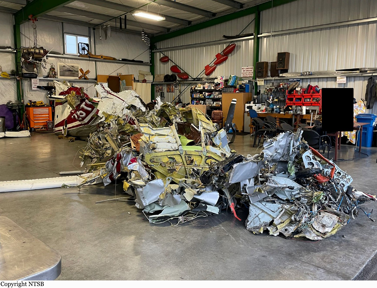
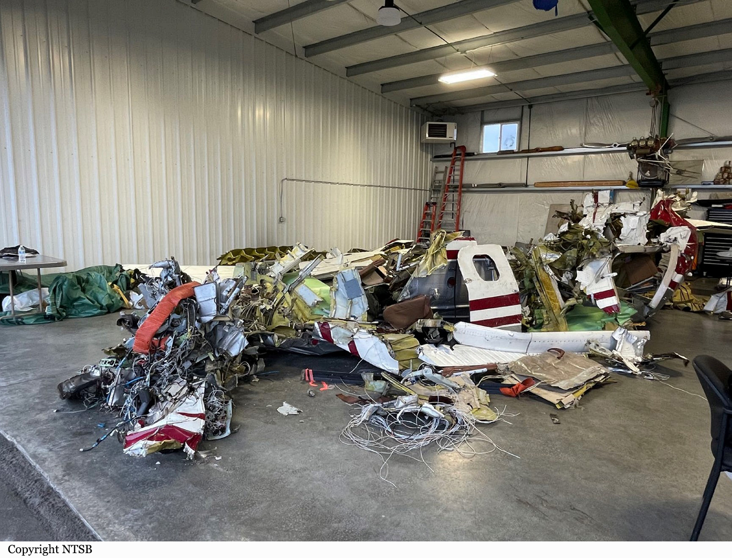
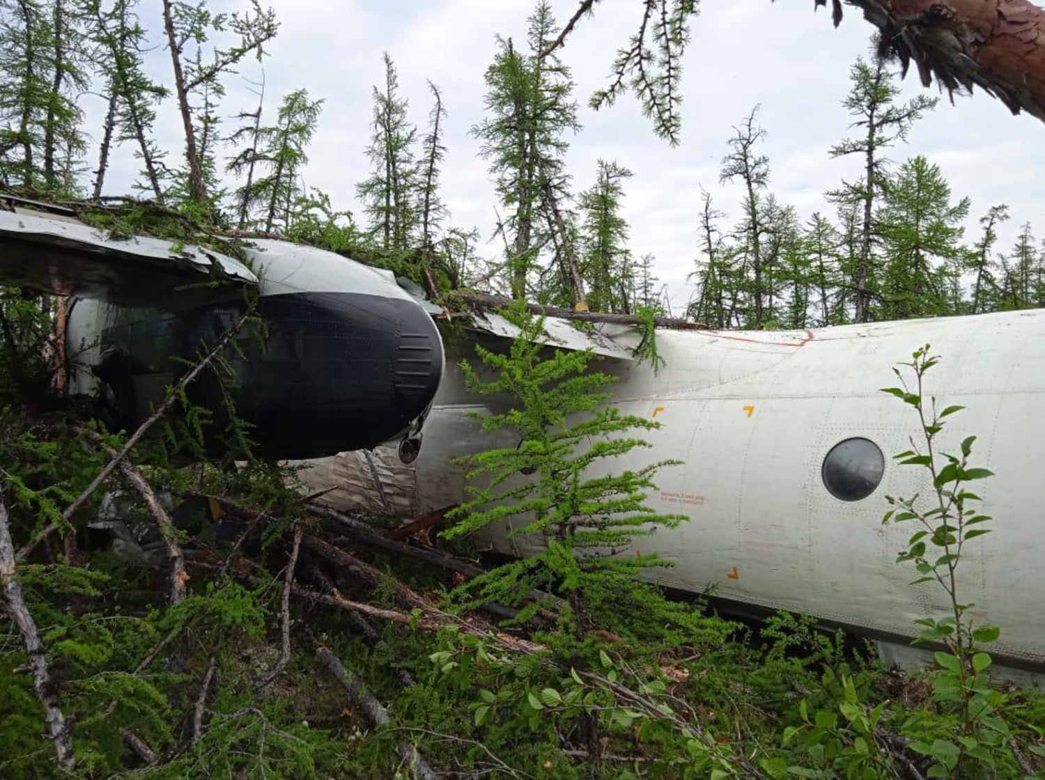
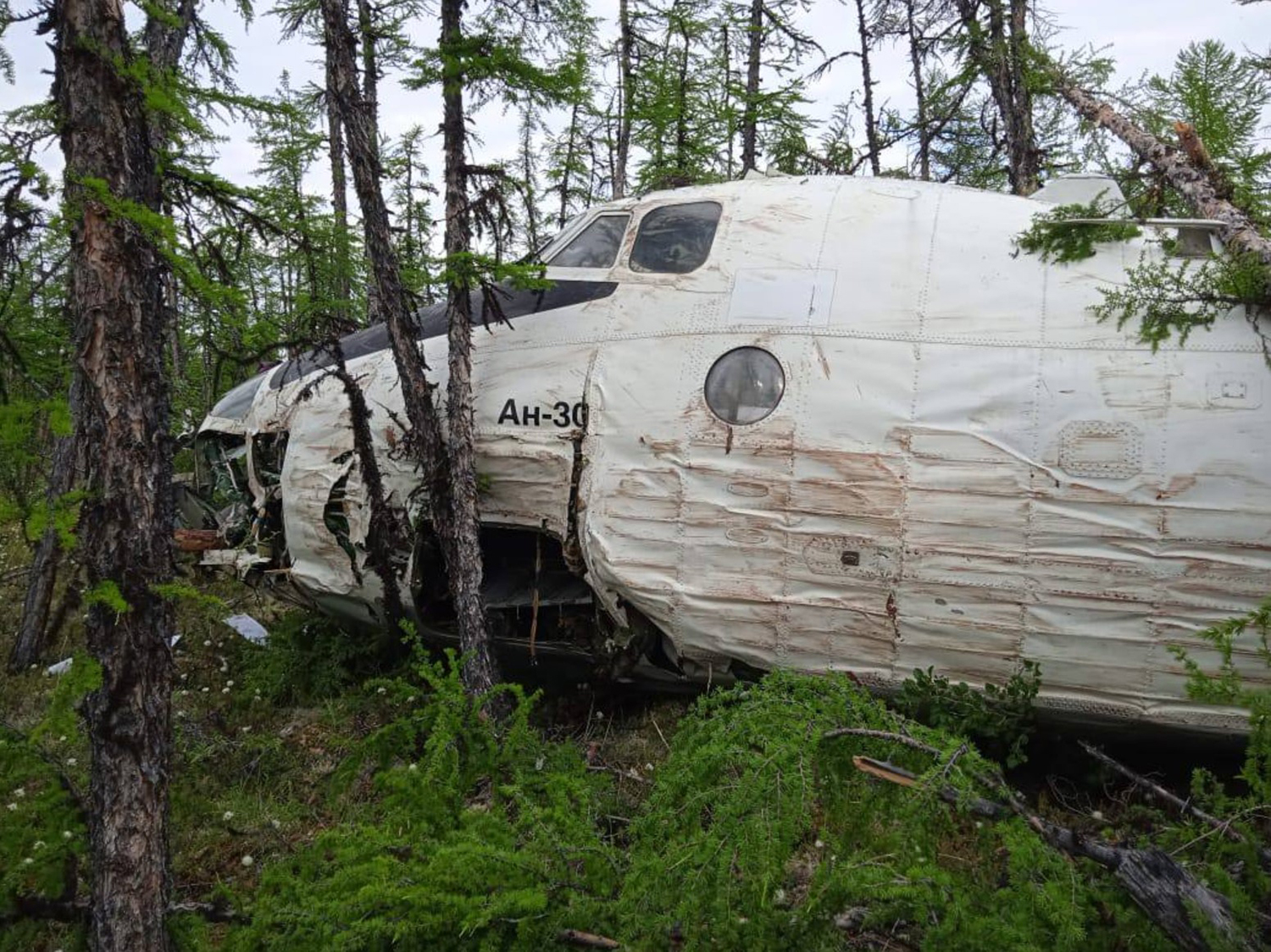
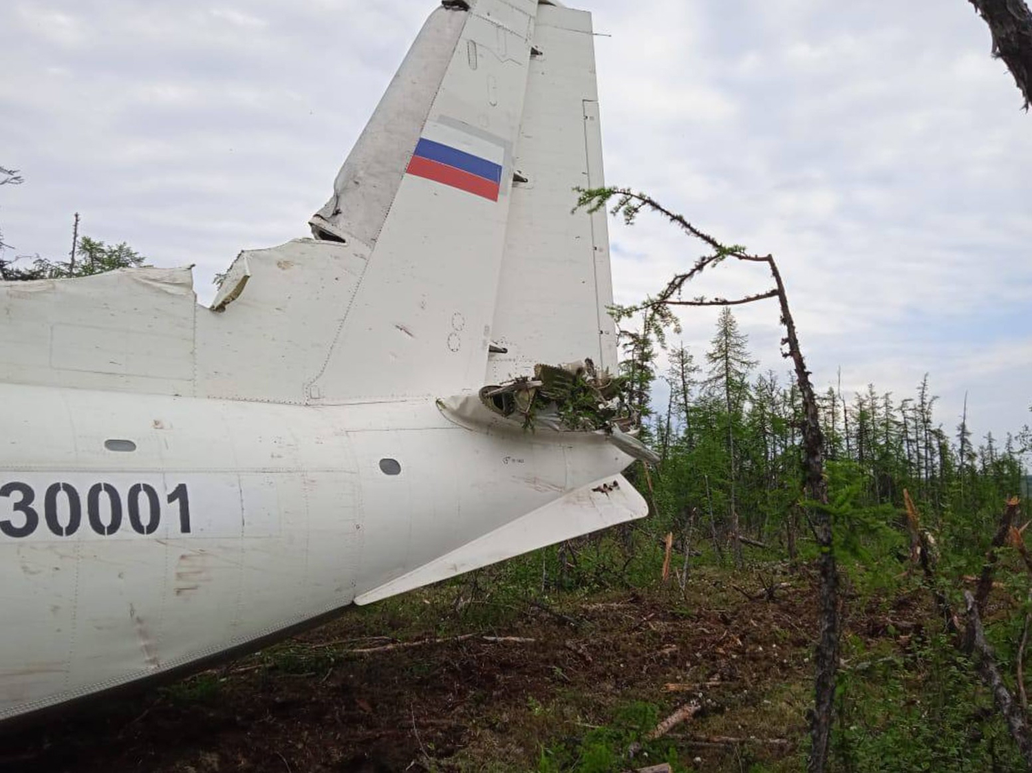
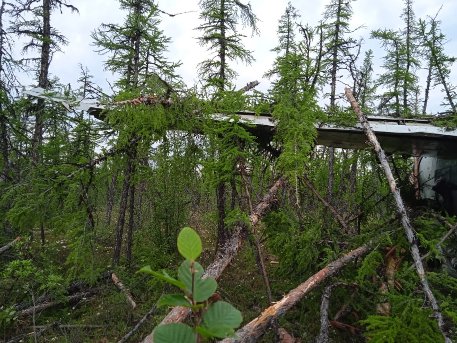
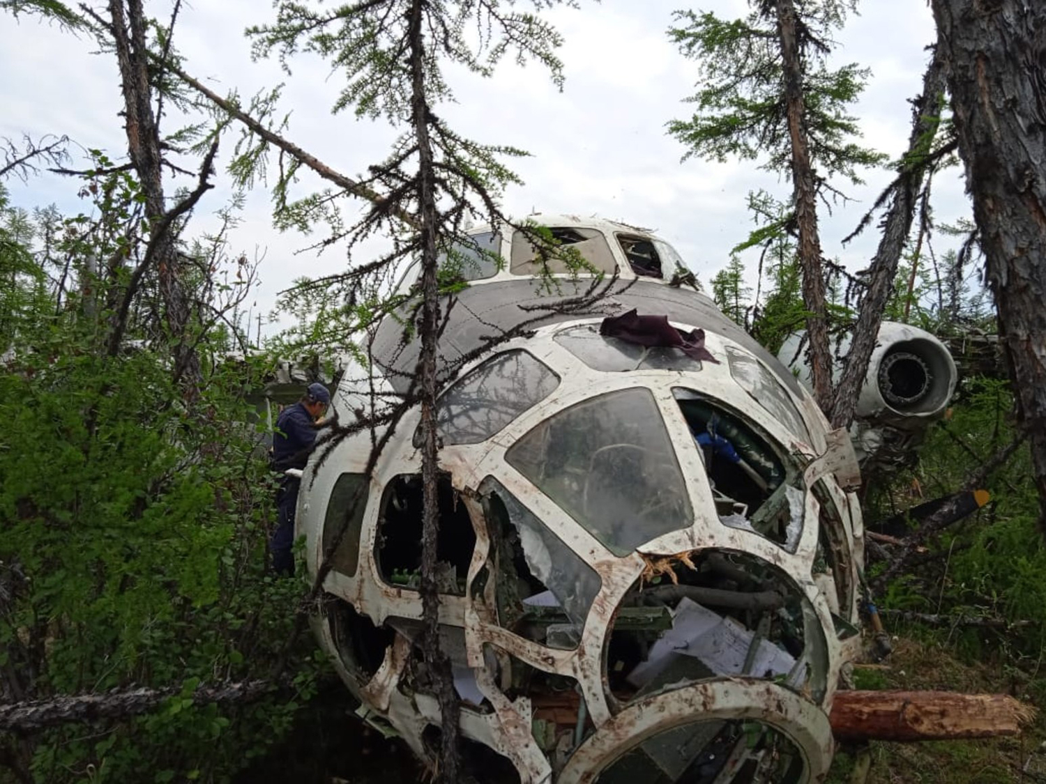
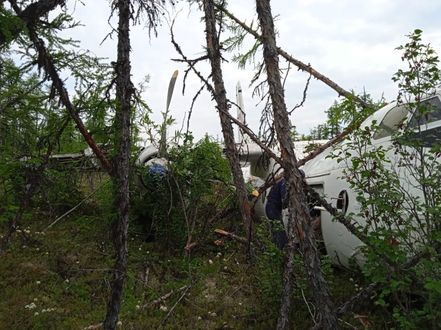
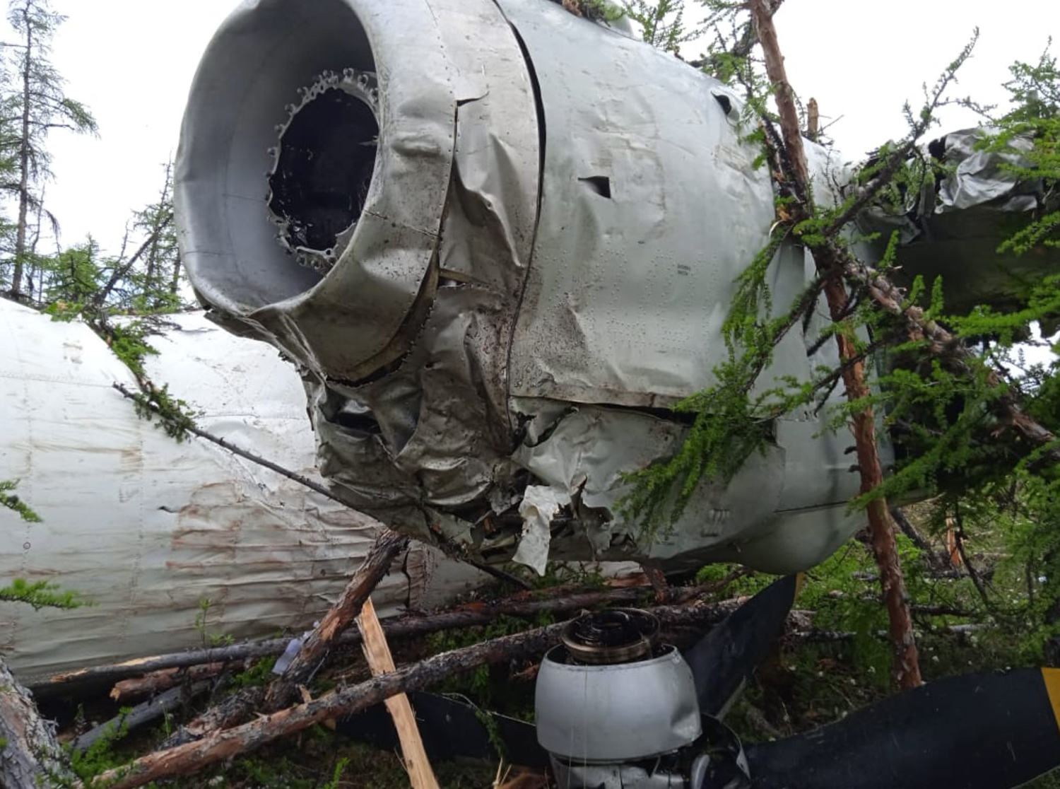
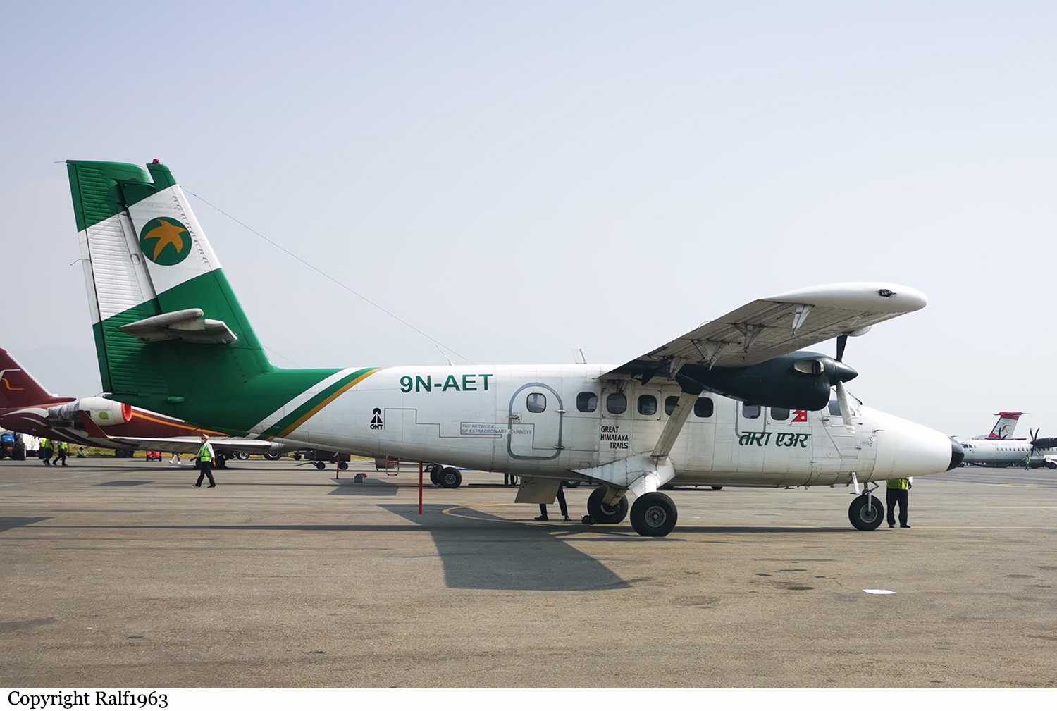
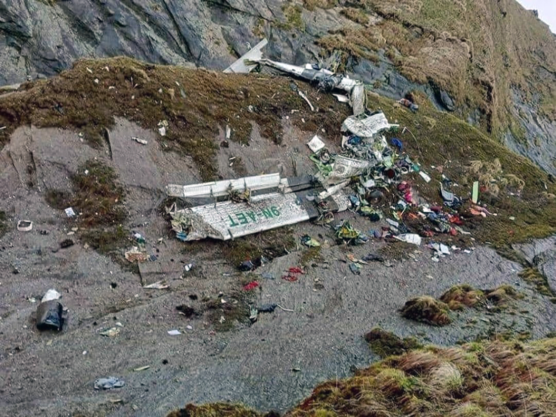
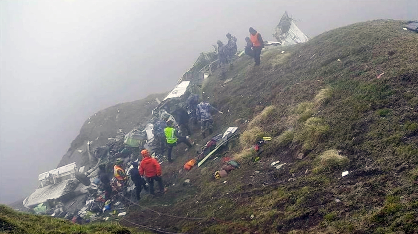
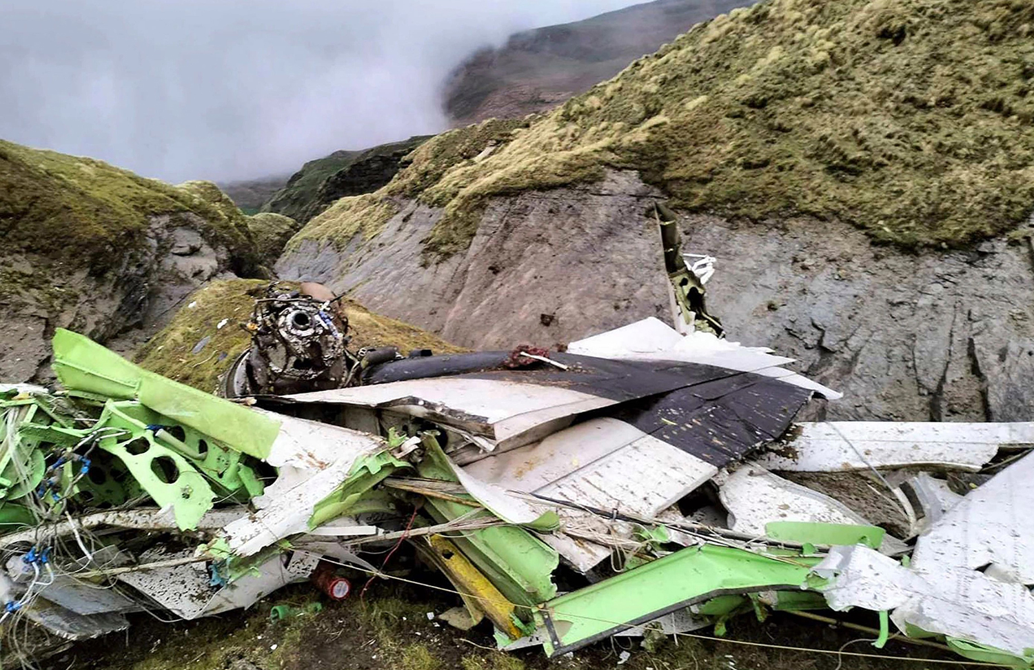
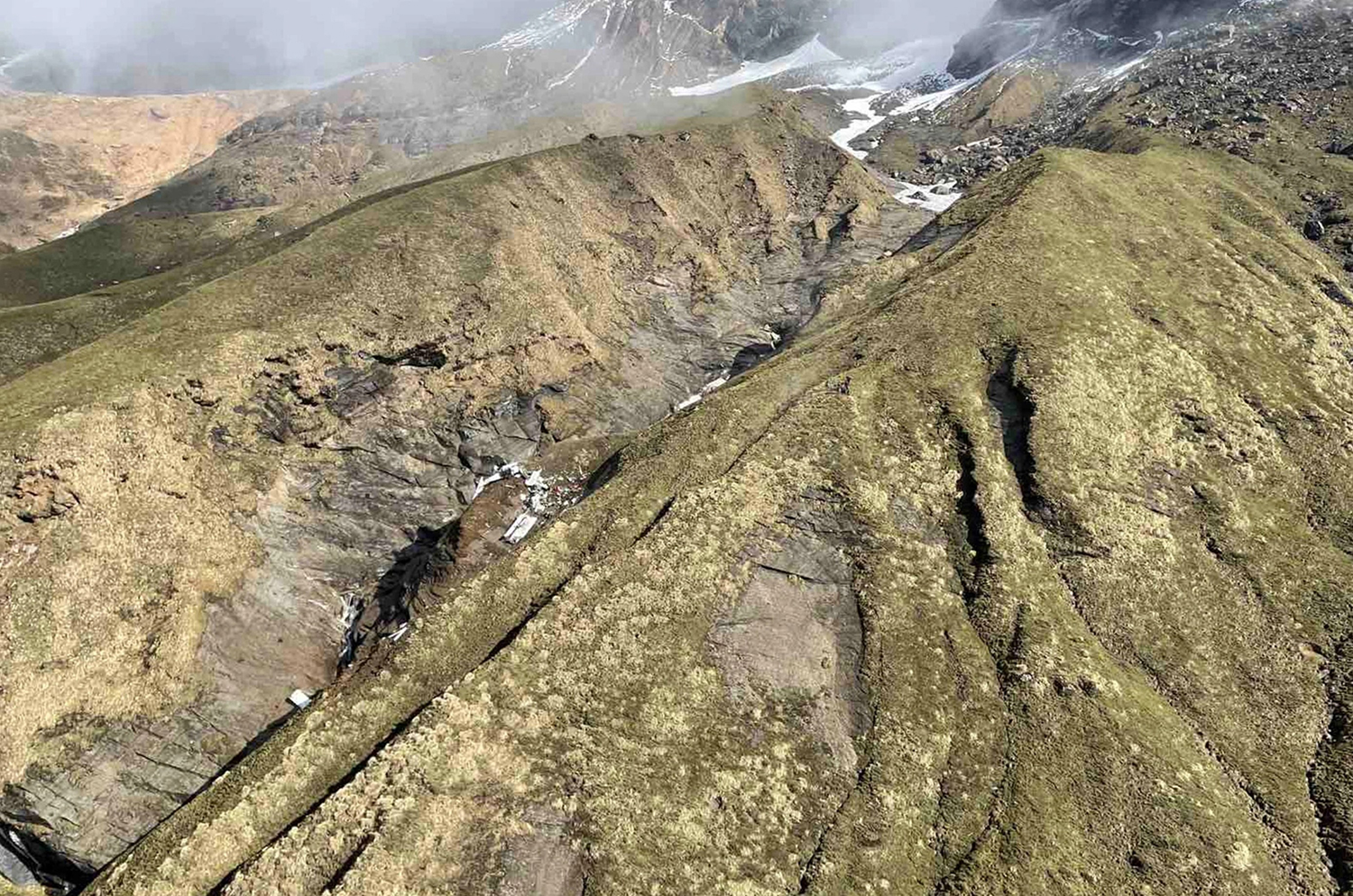
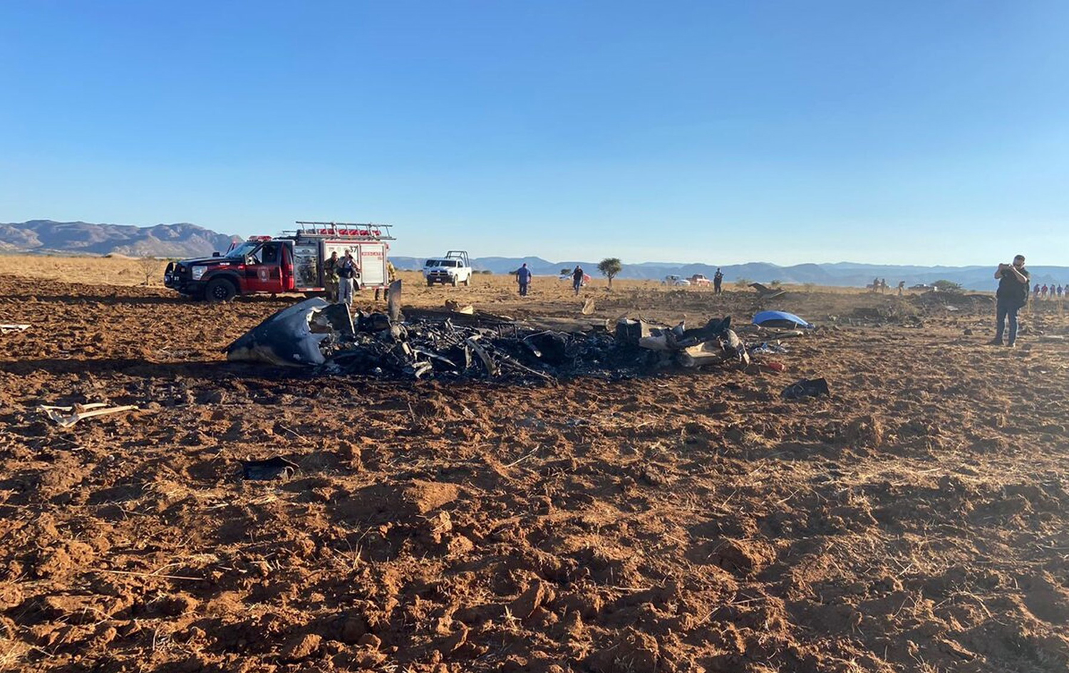
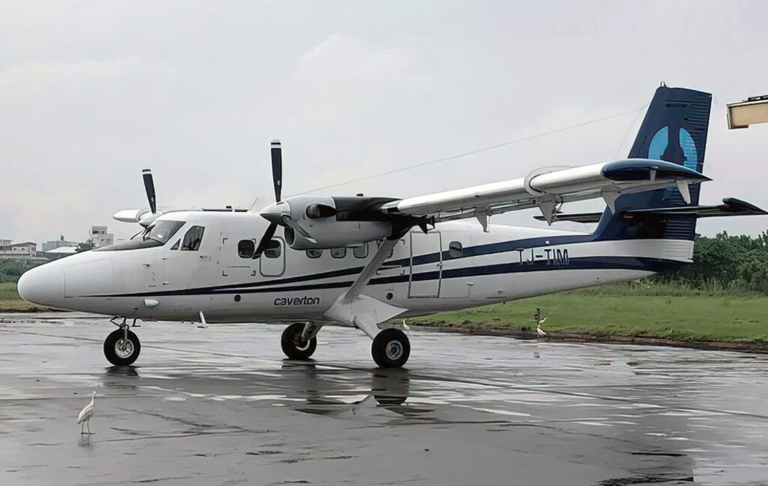
On 29 May 2022, Tara Air’s 9N-AET, Twin Otter (DHC-6/300) aircraft was scheduled for three flights on Pokhara-Jomsom-Pokhara sector. Tara Air had also filed flight plans for two additional Charter flights on the same sector. Among those five flights, four flights were to be conducted by a set of crews already positioned at Pokhara while the last flight was scheduled to be commanded by the PIC who had reached Pokhara from Kathmandu that very morning. Since Jomsom Airport was closed for operations due to bad weather, the PIC went to Tara Air crew camp and waited for the updates of weather improvement of Jomsom. After Jomsom Airport was open for operations at 0321 UTC, Tara Air operation decided to operate the first scheduled flight. However suspecting the next flight operation to Jomsom could not be operated, the original PIC assigned to the flight seated on board as a passenger to Jomsom for his scheduled business trip and the PIC assigned for the last flight took command. The Flight Plan was amended accordingly. At 0342 UTC, Summit Air’s 9N-AKZ, LET-410 took-off from Pokhara to Jomsom. At 0405 UTC, it reported an altitude of 12,500 ft and patches of cloud over Tatopani. At 0409 UTC, Summit Air’s second aircraft 9N-AMG, LET-410, took-off for Jomsom and subsequently, at 0410 UTC, 9N-AET of Tara Air (TRA197) took-off with 19 passengers and three crews on board. The Copilot had initially reported 3 crew and 18 passengers onboard to Pokhara Tower but later, revised the passenger figure was 19 prior to takeoff. 9N-AET was supposed to take-off before SMT 601 but the PIC seemed hesitant to commence the flight due to weather PIREP from 9N-AKZ that, the en-route weather was not favorable for VFR flights and critical around LETE and TATOPANI. All the crew members of TRA 197 and SMT 601 were in their respective cockpits and communicating with the preceding flight 9N-AKZ as well as with Pokhara tower for the updated information of en-route and destination weather. No flights had been conducted since morning and most of the passengers of Tara air and Summit Air were already at airport. In this situation it can be assumed that there was pressure to conduct flight from each angle. While listening to the CVR of TRA 197, it was observed that someone, either ground staff or some intimate passenger to the crew, advising strongly to the PIC to conduct the flight. Following the PIREP from 9NAKZ, both TRA197 and SMT 601 subsequently started their engines to commence the flights. The PIC of TRA 197 was still hesitant to conduct the flight for Jomsom even after the engine start and delayed the taxi as he was not yet convinced about the weather report received from preceding 9N-AKZ aircraft. In the meantime, SMT 601 lined up for departure to Jomsom. That was one of the most important pressure points to the PIC of TRA 197 to initiate departure. TRA 197 finally lined up and took off from Pokhara at 0410 UTC following the SMT 601 based on the en-route weather information (VMC) from 9N-AKZ, through Pokhara Tower. The en-route weather provided by Summit Air’s 9N-AKZ to Pokhara Tower and the crewmembers of TRA 197 and SMT 601 was not the same. Aircraft took off from Pokhara from runway 04 heading North. Tower instructed “report 5 DME northwest RW 04”. Then after departure at 90 climb power aircraft turned left to maintain a heading of 345 and planned to join heading 305 degree towards Ghodepani. After four minutes, TRA 197 reported, “Now on course…. 6000 climbing and ETA Jomsom 32” (0432 UTC). At 04:21 TRA 197 reported to Pokhara Tower as position approaching Ghodepani 12000 climbing for 12500. After 6 Seconds ATC Pokhara asked TRA 197, “confirm would like to change level and TRA 197 replied, “No Ma'am we have crossed Ghodepani and like to be on”. Pokhara Tower instructed, “Tara 197 contact Jomsom Tower 122.5” CVR recordings show that after TRA 197 crossed Ghodepani, the PIC was not comfortable with the en-route weather. However, the flight was continued following the advice of SMT 601. At 0426 UTC, TRA 197made the first contact with Jomsom AFS and reported its position to which Jomsom Tower conveyed the prevailing weather as “Wind South Westerly up to 30 kts, QNH 1019, Temp 18º”. The PIC of TRA 197 reconfirmed twice if the wind was maximum, up to 30 Kts and currently South Westerly-25kts. The crew was discussing about the bad weather being encountered and the PIC himself voiced his dissatisfaction about the behavior of other pilots who conduct VFR flights in such unfavorable weather. The CVR recordings reveal that the aircraft was encountering clouds and the PIC was trying his best to remain clear of the clouds. During the course of flight, TRA 197 hadn’t reported any abnormalities encountered and neither any technical defect on aircraft either to Jomsom tower or Pokhara Tower. As per CVR, PIC was searching for light and brighter areas and adamantly heading towards it. As per CVR and V2 tracker data, the aircraft was maintaining 12000 ft and was in a climbing attitude. During the continuous attempts of crew to avoid the clouds with Terrain Avoidance and Warning System [TAWS] inhibited, the aircraft met with an unfortunate CFIT accident into the rocky terrain at an altitude of 4050 meter AMSL at Sanusare Mountain, Thasang Rural Municipality, Mustang. As per V2 tracker, last position of 9N-AET was 7.7 nm SW of Jomsom Airport. The aircraft was completely destroyed by the impact and there were no survivors.
Probable cause:
The probable cause of this accident was the flight crew's failure to monitor and maintain the proper course while inadvertently flying in IMC conditions with the aircraft Terrain Avoidance and Warning System (TAWS) inhibited which resulted into a Controlled Flight Into Terrain (CFIT) accident.
The following contributing factors were identified:
1. The flight crew's failure to follow the SOP of company.
2. The aircraft flight operation with TAWS inhibited during deteriorating en-route weather condition.
3. Loss of situational awareness of crew.
4. Deteriorating en route weather.
5. Less experienced copilot for that sector and high crew gradient.
6. Poor CRM during the flight.
7. The whole cockpit duties [both PF and PM] were undertaken by the PlC, which likely impaired his performance.
8. Underutilization of the available Navigation instruments.
Final Report:

Crash of a Piper PA-61P Aerostar near Durango: 2 killed

Date & Time: May 23, 2022 at 1829 LT
Registration:
N66CG
Flight Phase:
Flight Type:
Survivors:
No
Schedule:
Celaya - Durango
MSN:
61-0277-061
YOM:
1976
Location:
Country:
Crew on board:
1
Crew fatalities:
Pax on board:
1
Pax fatalities:
Other fatalities:
Total fatalities:
2
Circumstances:
While approaching Durango Airport on a flight from Celaya, the twin engine aircraft entered an uncontrolled descent and crashed in an open field located near the village of Ceballos, about 16 km northwest of the Durango Intl Airport. The burned wreckage was found near the Peña del Aguila Dam. Both occupants were killed.

Crash of a Viking Air DHC-6 Twin Otter 400 near Nanga Eboko: 11 killed

Date & Time: May 11, 2022
Operator:
Registration:
TJ-TIM
Flight Phase:
Survivors:
No
Schedule:
Yaoundé – Dompta – Belabo
MSN:
934
YOM:
2015
Country:
Region:
Crew on board:
2
Crew fatalities:
Pax on board:
9
Pax fatalities:
Other fatalities:
Total fatalities:
11
Circumstances:
The twin engine airplane departed Yaoundé at 1246LT on a charter flight to Dompta and Belabo, carrying 9 employees of the Cameroon Oil Transportation Company (COTCO) and two crew members. En route, the airplane crashed in unknown circumstances near the village of Nanga Eboko. All 11 occupants were killed.

Crash of a Comp Air CA-8 in Grasmere: 2 killed

Date & Time: May 8, 2022 at 1419 LT
Type of aircraft:
Registration:
N801DT
Flight Phase:
Flight Type:
Survivors:
No
Schedule:
Boulder City – Boise
MSN:
027078SS52T03
YOM:
2007
Location:
Crew on board:
1
Crew fatalities:
Pax on board:
1
Pax fatalities:
Other fatalities:
Total fatalities:
2
Captain / Total flying hours:
1350
Aircraft flight hours:
685
Circumstances:
The pilot and passenger departed on a cross-country flight. Automatic dependent surveillance – broadcast (ADS-B) data indicated that the airplane flew at a cruise altitude between 11,000 ft and 13,000 ft mean sea level (msl) on a north to northeast heading consistent with its planned destination for most of the flight. About 30 minutes before the end of the flight, the airplane began a descent and then turned east. Shortly thereafter, the pilot of the airplane declared minimum fuel with air traffic control (ATC). A few minutes later the pilot declared critical fuel due to a fuel leak. The pilot stated in his last communication that he would attempt to make a nearby airport. Subsequently, the airplane impacted hilly, desert terrain at an elevation of about 5,780 ft and on a heading of about 034°. An acquaintance of the pilot who was a flight instructor stated that, on the two previous flights he had flown with the pilot, the left wing of the airplane felt heavy. The accident pilot thought it was because of a fuel imbalance. The postaccident examination revealed that the left tank fuel valve was positioned ON and the right tank valve was positioned OFF, consistent with the pilot balancing the fuel by feeding from the left-wing fuel tank. It is possible that when the pilot noticed the minimum fuel status, he failed to recall that he had previously selected the rightside fuel tank OFF, and thus did not have this fuel available. Given that the cruise altitudes on the accident flight were similar to what the previous owner used to make his fuel range and duration estimates, even with about a 20% reduction in fuel due to the pilot allowing 2 inches from the top of the fuel tanks during refueling, the airplane should have had adequate fuel to make its destination. A strong smell of fuel and fuel staining were also observed at the accident site. Page 2 of 11 WPR22FA173 A review of radar imagery from Boise, Idaho, revealed that the airplane flew through several areas of light to moderate intensity echoes as it proceeded northward, and then after turning eastward, the airplane’s fight track was through an area of moderate to heavy intensity echoes. The accident site was located on the southeast edge of the echo. Light-to-moderate icing conditions in the clouds with clear to mixed type icing below 12,000 ft msl were expected. Thus, it is likely that the airplane, which was not certified for flight in icing, encountered icing in the final portion of the flight. The pilot was flying with insulin-dependent diabetes, having type 1 diabetes mellitus. Given the urine glucose level of 29mg/dL, no detectable glucose in vitreous fluid, and ongoing verbal communication, it is unlikely that the pilot was experiencing significant metabolic disturbance from high blood glucose. Whether he was experiencing less severe effects of high blood sugar could not be determined. Whether he had symptoms of low blood glucose, such as diminished concentration or increased nervousness, is unknown. The pilot’s use of diphenhydramine (Benadryl), which can cause sleepiness, was likely not a factor due to fact that it was detected only in the urine and not in the blood. Thus, it is unlikely that effects of the pilot’s diphenhydramine use contributed to the accident. Accident site signatures and a review of the weather were consistent with a loss of control of the airplane. In addition, an examination of the airframe and engine revealed no evidence of any preimpact mechanical failures or malfunctions that would have precluded normal operation. It is likely that, while maneuvering to an alternate airport due to a critical fuel situation, in icing conditions, the pilot failed to maintain the proper airspeed, which resulted in the exceedance of the airplane’s critical angle of attack and the airplane experiencing an aerodynamic stall.
Probable cause:
The pilot’s failure to maintain proper airspeed and his exceedance of the airplane’s critical angle of attack, which resulted in an aerodynamic stall.
Final Report: