Crash of a Partenavia P.68B off the Wilsons Promontory National Park: 2 killed

Date & Time: Jul 2, 1978 at 1622 LT
Type of aircraft:
Operator:
Registration:
VH-FAX
Flight Phase:
Flight Type:
Survivors:
No
Schedule:
Flinders Island - Melbourne
MSN:
46
YOM:
1975
Country:
Region:
Crew on board:
1
Crew fatalities:
Pax on board:
1
Pax fatalities:
Other fatalities:
Total fatalities:
2
Captain / Total flying hours:
420
Captain / Total hours on type:
200.00
Circumstances:
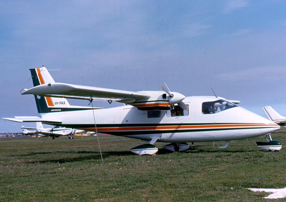
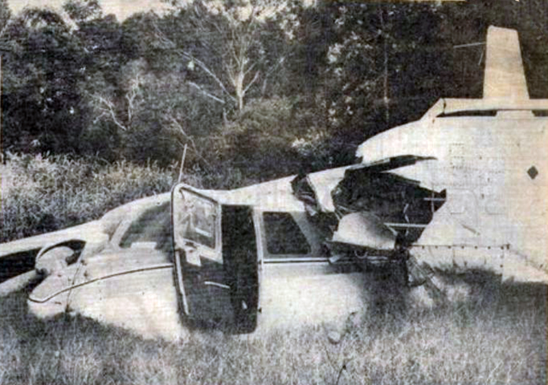
On the morning of 2.7.78 the pilot obtained the relevant meteorological forecasts and submitted a flight plan to the Moorabbin Briefing Office for a flight from Moorabbin to Flinders Island and return. He did not hold an instrument rating and was therefore restricted to flight in accordance with the Visual Flight Rules (VFR). The forecasts indicated patches of fog over the route initially, with areas of rain developing later in the day. Broken layers of stratus and strato-cumulus cloud were forecast but there was nothing to suggest that VFR flight would not be possible. The VFR flight plan submitted indicated an estimated flight time of 89 minutes to Flinders Island and 72 minutes for the return flight. The fuel endurance was stated as 300 minutes. After being refuelled to capacity, the aircraft departed from Moorabbin at 1007 hours and the pilot subsequently reported in the Flinders Island circuit area at 1143 hours. The aircraft landed at Flinders Island Aerodrome and the pilot and passenger proceeded by motor vehicle to a farming property some 40 kilometres distant. On returning to the aerodrome later in the day the pilot attempted to obtain up-to-date weather information for the return flight but the telephone was found to be unserviceable. By this time, the earlier forecasts covering the route had been amended and generally indicated some deterioration in conditions, particularly in relation to increased cloud at the lower levels. Nevertheless, the forecast conditions suggested that VFR flight could be possible over the route. The amended terminal forecast for Moorabbin also indicated increasing low cloud. The pilot and the passenger were seen to board the aircraft which then took off and circled the aerodrome before being obscured by cloud. At this time the weather to the south of Flinders Island Aerodrome was squally and the nearby mountain was partly covered by cloud. At 1543 hours the pilot established radio communication with Launceston Flight Service Unit (FSU) and reported his departure from Flinders Island at 1541 hours, his intention to cruise below 5000 feet and his estimated time over South East Point (southern end of Wilson's Promontory) as 1617 hours. He also asked for confirmation that Moorabbin Airport was open to VFR traffic. He was advised that Moorabbin was "not closed to VFR at the moment however they expect it to be". He was also given the current terminal forecast for Moorabbin and the sections of the relevant area forecasts relating to cloud. He was requested to call Melbourne FSU at 1550 hours. At 1551 hours the pilot established communication with Melbourne FSU and, at 1600 hours, he again asked for confirmation that Moorabbin Airport was open to VFR operations and was advised in the affirmative. He then reported that he was climbing to his planned altitude of 6500 feet and, at 1607 hours, reported that he was climbing to 8500 feet. At 1620 hours he reported an amended estimated time over South East Point as 1625 hours and again requested confirmation that Moorabbin was still open to VFR operations. He was again advised in the affirmative. At 1622 hours the pilot broadcast the call sign of the aircraft once very rapidly and the pitch of his voice was raised above normal. The flight service officer heard but did not understand the call and twice requested the calling aircraft to repeat its call. There was no reply and no further communications were received from the aircraft. Following failure of the aircraft to report position at South East Point, the Uncertainty Phase of search and rescue procedures was declared at 1640 hours. When widespread checks failed to establish the location of the aircraft, the Alert Phase was declared at 1713 hours and this was upgraded to the Distress Phase at 1745 hours. A search of the probability area was carried out by air, land and sea during the next three days and, on the morning of 3. 7. 78, two seats and a left main wheel assembly from a Partenavia P68B aircraft were found on the eastern shoreline of Wilson's Promontory. Additionally, three life jackets with the name "TIPPETT" stencilled on them were found in the same area. No trace of the main wreckage of the aircraft, or of the occupants, has been found. Damage to the recovered aircraft seats and wheel assembly was consistent with them having been attached to an aircraft which had struck the water at high speed in a nose down, left wing down attitude. Post analysis of the meteorological situation at the time of the accident indicated that a complex low pressure system was moving across Victoria. There was extensive cloud cover in the Wilson's Promontory area and the base of the lowest cloud was 1000/2000 feet. Visibility was reduced in areas of heavy rain showers. The interaction of differing air masses could have produced conditions conducive to severe airframe icing In respect of aircraft operating at altitudes between 5000 and 7000 feet.
Probable cause:
There is insufficient evidence available to enable the cause of this accident to be determined.
Final Report:

Crash of a Piper PA-31-350 Navajo Chieftain in Melbourne: 1 killed

Date & Time: Mar 30, 1978 at 0144 LT
Registration:
VH-MBK
Flight Phase:
Flight Type:
Survivors:
No
Schedule:
Melbourne - Canberra
MSN:
31-7405196
YOM:
1974
Country:
Region:
Crew on board:
1
Crew fatalities:
Pax on board:
0
Pax fatalities:
Other fatalities:
Total fatalities:
1
Captain / Total flying hours:
13017
Captain / Total hours on type:
1531.00
Circumstances:
The aircraft was based at Moorabbin Airport and, late in foe afternoon of 29.3.78, it was refuelled and a pre-flight inspection was carried out. The pilot ferried it to Melbourne Airport just after midnight. While he was preparing and submitting a flight plan for the flight to Canberra and return, the aircraft was loaded with newspapers and a small quantity of other freight. On returning to the aircraft, the pilot checked the loading documents and the freight and made a walk around inspection of the exterior of the aircraft. The pilot started the aircraft engines and established radio communication with air traffic control at 0139 hours. He was given a taxi clearance and an airways clearance for departure from runway 34. Upon request, he was granted approval to commence take-off from the taxiway "J" intersection, some 800 metres from the southern end of the runway. He reported "ready" at 0143 hours and was immediately given a clearance for take-off. The aircraft commenced to take-off, became airborne and, when it was at a height of 100 to 200 feet above the intersection of the two runways, the pilot advised "got a fire - fire in the ah starboard engine and ah doing a low circuit request two seven". Air traffic control immediately replied "make visual approach runway two seven clear to land". Acknowledgement of this clearance was the last communication received from the aircraft. As the aircraft passed over the northern end of runway 34 it commenced a turn to the right and gradually descended. It struck the ground in a right wing down attitude on a track of 070° magnetic and an intense fire broke out. The accident site was 1.8 kilometres to the north-east, and 88 feet above the elevation, of the northern end of runway 34. At the time of the accident the surface wind was 330°/9 knots, the visibility was 25 km in passing showers, there was 3 oktas stratus cloud base 1800 feet and 6 oktas cumulus cloud base 3500 feet. It is probable that below 1000 feet there was some wind shear, downdrafts from passing showers and intermittent moderate turbulence. It has been calculated that the gross weight of the aircraft was some 65 kilograms in excess of the maximum take-off weight and the centre of gravity was within limits. A detailed examination of the wreckage of the aircraft revealed that the landing gear and flaps were fully retracted, the cowl flaps of both engines were midway between the open and closed positions a considerable degree of nose left rudder trim was selected, the right engine was closed down and the propeller feathered. It was established that, as a result of excessively lean mixture operation, there was a hole burned through the piston rings and into the side of the No. 2 piston of the right engine. There was no evidence of fire within the engine but it was apparent that the hole in the piston had resulted in pressurisation of the crankcase cavity, ejection of the oil dipstick and the consequent venting of oil from the dipstick orifice and the engine breather pipe on to the exterior of the exhaust pipes. The engine had the capacity to continue to produce a substantial amount of power for a limited period. The turbo-charger density controller of the left engine was found to be incorrectly adjusted to the extent that the engine could develop only about 330 BHP instead of 350 BHP of which it was normally capable.
Probable cause:
The probable cause of the accident was that, believing there was an internal fire in the right engine, the pilot closed the engine down in circumstances where the single-engine performance capability of the aircraft proved to be insufficient to sustain continued flight.
Final Report:

Crash of a Britten Norman BN-2A Islander in Landsborough

Date & Time: Mar 30, 1978
Type of aircraft:
Operator:
Registration:
VH-EQK
Flight Type:
Survivors:
Yes
Schedule:
Toowoomba – Landsborough
MSN:
146
YOM:
1970
Country:
Region:
Crew on board:
2
Crew fatalities:
Pax on board:
0
Pax fatalities:
Other fatalities:
Total fatalities:
0
Circumstances:
On approach to Landsborough Airfield, the twin engine airplane slipped between trees and power lines and ploughed into a swampy ground. Both pilots were slightly injured and the aircraft was damaged beyond repair.

Crash of a Rockwell Grand Commander 680 near Katherine

Date & Time: Jan 22, 1978
Operator:
Flight Type:
Survivors:
Yes
Country:
Region:
Crew on board:
2
Crew fatalities:
Pax on board:
0
Pax fatalities:
Other fatalities:
Total fatalities:
0
Circumstances:
The crew was completing a drug smuggling flight and attempted to land on an abandoned airstrip located about 6 km west of Katherine. After the mishap, the crew set afire the airplane and left before being arrested by the police. On board was a load of 200,000 opium sticks for a total value of 3 millions US$.

Crash of a Pilatus PC-6/B1-H2 Turbo Porter in Buckambool

Date & Time: Mar 23, 1977
Operator:
Registration:
A14-692
Flight Type:
Survivors:
Yes
MSN:
692
YOM:
1968
Country:
Region:
Crew on board:
0
Crew fatalities:
Pax on board:
0
Pax fatalities:
Other fatalities:
Total fatalities:
0
Circumstances:
Damaged beyond repair following a hard landing at Buckambool. There were no casualties.

Crash of a Piaggio P.166AL-1 Albatross near Marulan: 1 killed

Date & Time: Feb 22, 1977 at 0755 LT
Type of aircraft:
Operator:
Registration:
VH-GOC
Flight Phase:
Flight Type:
Survivors:
No
Site:
Schedule:
Bankstown - Warracknabeal
MSN:
403
YOM:
1961
Country:
Region:
Crew on board:
1
Crew fatalities:
Pax on board:
0
Pax fatalities:
Other fatalities:
Total fatalities:
1
Captain / Total flying hours:
12000
Captain / Total hours on type:
1200.00
Circumstances:
The pilot attended the Bankstown Briefing Office at about 0600 hours. He was briefed concerning the current weather conditions at Bankstown Airport, which were Instrument Meteorological Conditions (IMC) but were Improving to VMC; and the relevant meteorological forecasts which indicated, for his proposed route, that he might experience some difficulty in maintaining flight In Visual Meteorological Conditions (VMC). The pilot's licence was not endorsed to permit him to operate in other than VMC. He then submitted a flight plan for a flight from Bankstown Airport to Warracknabeal and return, proceeding over Marulan the estimated time interval thereto being 33 minutes, the flight to be conducted in accordance with the Visual Flight Rules (VFR) at altitudes not exceeding 5000 feet. The aircraft departed Bankstown Airport, in VMC, and established two way communication with Sydney Flight Service Unit (FSU). At 0748 hours the pilot advised the Sydney FSU that he was "returning to Camden, estimating Camden at one five". In response to a query the pilot advised "weather okay". No further communications were received from the aircraft. At about 0755 hours the aircraft was heard and observed flying in an easterly direction some 20 kilometres north-northeast of Marulan. There was low cloud and some light rain in the area. The aircraft was flying below the cloud base and was at a height of 500 feet to 200 feet above undulating terrain, proceeding towards rugged terrain which was gradually rising. Subsequently the aircraft proceeded over a ridge line out of the sight of witnesses. Shortly thereafter the engine noise ceased abruptly. The police were alerted and search and rescue action was initiated. The wreckage of the aircraft was located some eight hours later. The aircraft had crashed on a heavily timbered 12 degree upslope about 100 feet below a ridge line. At Impact the aircraft was in a nose down attitude and was banked some 45 degrees to the right. The right hand propeller was feathered and the engine had not been operating at impact. The left hand engine had been under power. The landing gear and flaps had been fully retracted. The available evidence Indicates that the gross weight of the aircraft was at or about the maximum permissible all up weight. Examination of the right hand engine revealed massive internal failure which had commenced with the failure of the right hand dowel In the Number 2 main crankcase bearing. It is probable that the dowel failed because of abnormal loads resulting from loss of bearing nip associated with crankcase fretting at the lower through bolt of the Number 2 bearing saddle. It is estimated that the engine had operated some 170 hours since issue of the last maintenance release on 26 October 1976.
Probable cause:
The probable cause of the accident was that, in the conditions pertaining, the single engine performance of the aircraft was insufficient to ensure maintenance of adequate terrain clearance whilst flying over undulating terrain at a low eight. Internal structural failure of right hand engine, Lycomtng GSO480-BIC6 Serial number L3050-33. Left hand engine carburettor air temperature control valve detached from actuating shaft.
Final Report:

Crash of a GAF Nomad N24 in Avalon: 2 killed

Date & Time: Aug 6, 1976 at 1103 LT
Type of aircraft:
Registration:
VH-SUZ
Flight Phase:
Flight Type:
Survivors:
Yes
Schedule:
Avalon - Avalon
MSN:
10
YOM:
1975
Location:
Country:
Region:
Crew on board:
3
Crew fatalities:
Pax on board:
0
Pax fatalities:
Other fatalities:
Total fatalities:
2
Captain / Total flying hours:
4483
Captain / Total hours on type:
73.00
Aircraft flight hours:
139
Circumstances:
At approximately 1103 hours Eastern Standard Time (EST) on 6 August 1976 the pilot of Nomad N24 aircraft Serial Number 10 encountered control difficulty at a height of about 950 feet immediately after taking off at Avalon Aerodrome. The aircraft entered a descending turn to the left through about 175 degrees and struck the ground. The pilot was killed; the occupant of the other pilot seat, an observer, sustained injuries which resulted in his death two days later; and the third occupant, the flight test engineer, was seriously injured.
Probable cause:
The cause of the accident was that the simplified design criterion which was used to justify freedom from flutter during the flight testing of various tail plane modifications was not valid for a design which included tab trailing edge T strips.
Final Report:

Crash of a Pilatus PC-6/B1-H2 Turbo Porter in Cooma: 3 killed

Date & Time: May 20, 1976 at 1002 LT
Operator:
Registration:
VH-SMB
Survivors:
No
Schedule:
Talbingo – Khancoban – Cooma
MSN:
657
YOM:
1967
Country:
Region:
Crew on board:
1
Crew fatalities:
Pax on board:
2
Pax fatalities:
Other fatalities:
Total fatalities:
3
Captain / Total flying hours:
13138
Captain / Total hours on type:
3000.00
Circumstances:
The aircraft departed Polo Flat at 0750 hours on a planned flight to Khancoban, Talbingo and return. There was dense fog at Polo Flat at this time and the aircraft took off and climbed through fog until it was in clear conditions above. At Cooma Aerodrome, fog which had existed earlier dissipated about 0715 hours and the weather at that location then remained clear. When the aircraft returned to the Polo Flat area shortly after 0930 hours, fog was still present but it was commencing to break with patches of blue sky visible from time to time. Information regarding the weather conditions was communicated to the, pilot who had established radio contact with the base operations officer at Polo Flat. Shortly after the aircraft arrived in the area it was observed to make what appeared to be a landing approach into the north but when it had descended to a height of 10 to 15 feet the approach was discontinued and it climbed away. After flying for some time above the fog at a height of about 500 feet the aircraft was heard approaching from the south and the operations officer heard the pilot transmit the words 'hit the...'. Shortly afterwards the sound of an impact was heard. The port wing of the aircraft had struck the radio transmitter mast 32 feet from the top and the aircraft crashed to the ground in a steep nose-down attitude some 146 metres north of the mast. A fierce fire developed shortly after impact.
Crew:
John Howard, pilot.
Passengers:
Evelyn Anne Harvey,
Patricia Joy Harvey.
Probable cause:
The probable cause of the accident was that the aircraft was operated at an unsafe height in weather conditions in which the pilot was not able to maintain the visual reference necessary to ensure adequate clearance from obstructions.
Final Report:

Crash of a Beechcraft 65-A80 Queen Air in Ingelara

Date & Time: Dec 17, 1975
Type of aircraft:
Operator:
Registration:
VH-TGA
Flight Phase:
Flight Type:
Survivors:
Yes
Schedule:
Ingelara - Gladstone
MSN:
LD-152
YOM:
1964
Country:
Region:
Crew on board:
1
Crew fatalities:
Pax on board:
3
Pax fatalities:
Other fatalities:
Total fatalities:
0
Circumstances:
While taking off from Ingelara Airstrip, the twin engine airplane crashed in unknown circumstances. It was damaged beyond repair and all four occupants were rescued. The airplane was completing an ambulance flight.

Crash of a De Havilland DH.114 Heron 2E in Cairns: 11 killed

Date & Time: Oct 23, 1975 at 1928 LT
Type of aircraft:
Operator:
Registration:
VH-CLS
Survivors:
No
Schedule:
Alice Springs - Mount Isa - Cairns
MSN:
14067
YOM:
1955
Flight number:
CK1263
Country:
Region:
Crew on board:
3
Crew fatalities:
Pax on board:
8
Pax fatalities:
Other fatalities:
Total fatalities:
11
Captain / Total flying hours:
3859
Captain / Total hours on type:
1030.00
Copilot / Total flying hours:
184
Copilot / Total hours on type:
109
Aircraft flight hours:
14986
Circumstances:
DH-114 Heron registered VH-CLS was operating Connair Flight 1263 from Alice Springs to Cairns landing at Mount Isa en route. At 12:57 hours VH-CLS taxied to runway 30 at Alice Springs and was cleared for takeoff. The flight landed at Mount Isa at 15:35 hours after making a visual approach. At 16:46 hours VH-CLS taxied to runway 34 at Mount Isa, and the flight reported its departure as 16:55 hours at which time it was climbing to its planned cruising altitude of 7000 feet. As the flight progressed position reports at the appropriate reporting points were received. At 18:01 hours, VH-CLS advised that it was descending to cruise at 6000 feet. Subsequently, at 18:49 hours, VH-CLS reported as being at the Saucebottle Creek position, 146 km southwest of Cairns, at an altitude of 6000 feet. The crew indicated an ETA at the Biboohra VOR, 35 km west of Cairns, of 19:12. VH-CLS was then advised by the Cairns aerodrome/approach controller, through the Cairns Flight Service Unit (FSU), to expect an ILS approach to runway 15 at Cairns Airport. At 18:54 hours the Cairns aerodrome/approach controller issued an air traffic clearance, for transmission through the Cairns FSU, authorising VH-CLS to enter the control area via the 049 degree radial of the Biboohra VOR cruising at 6000 feet and using an altimeter setting of 1006 millibars. At about 18:55 hours, the Weather Service Office (WSO) located at Cairns Airport observed a thunderstorm, without precipitation, in the vicinity of the airport and the following 'special' aerodrome weather report was issued: Wind : 360 degrees at 6 knots, visibility : 10 km or more, thunderstorm without precipitation, 1/8 cumulonimbus clouds, base 3000 feet, 4/8 cumulus, base 2300 feet, 4/8 strato cumulus, base 4000 feet. This was reported to the crew. At 19:10 hours, VH-CLS reported to the Cairns aerodrome/approach controller that it was over the Biboohra VOR at 6000 feet and, following confirmation by VH-CLS that its 'preferred approach' was an ILS approach, it was cleared 'on the Biboohra zero four nine radial, descend to three seven zero zero for an ILS approach runway one five, and report at Buchan Locator'. VH-CLS acknowledged this instruction and advised that the aircraft was leaving 6000 feet. At 19:17:29 hours, VH-CLS reported over the Buchan Locator turning outbound onto a heading of 330 degrees this being the standard ILS procedure; the aerodrome/approach controller cleared the aircraft for an ILS approach and instructed it to report leaving 3700 feet. At 19:20:54 hours, VH-CLS reported 'leaving three seven zero zero' implying that the aircraft had commenced the final approach segment of the ILS approach. The aerodrome/approach controller acknowledged the report and radioed: 'wind from the northwest, maximum downwind component runway one five not above six knots, runway wet, clear to land'. At 19:22:53 hours, the controller notified VH-CLS 'there's a moderately heavy shower at the field now, visibility er is reducing as the shower moves south, visibility to the south at the moment er in excess of four thousand metres, high intensity approach and runway lighting is on, advise when you would like the intensity decreased'. VH-CLS acknowledged. At 19:26:23 hours, VH-CLS reported 'going round' and the aerodrome/approach controller instructed VH-CLS to 'make missed approach on a heading of zero three five and climb to three seven zero zero'. VH-CLS turned away from the airport, descended to a low height above terrain, and completed about 270 degrees of a left hand orbit. It then entered a turn to the right during which it descended and crashed.
Probable cause:
The cause of the accident was that, following misalignment of the aircraft with the runway and abandonment of the landing approach, the pilot in command did not immediately initiate a climb to a safe altitude. Why such action was not taken has not been determined.
Final Report: