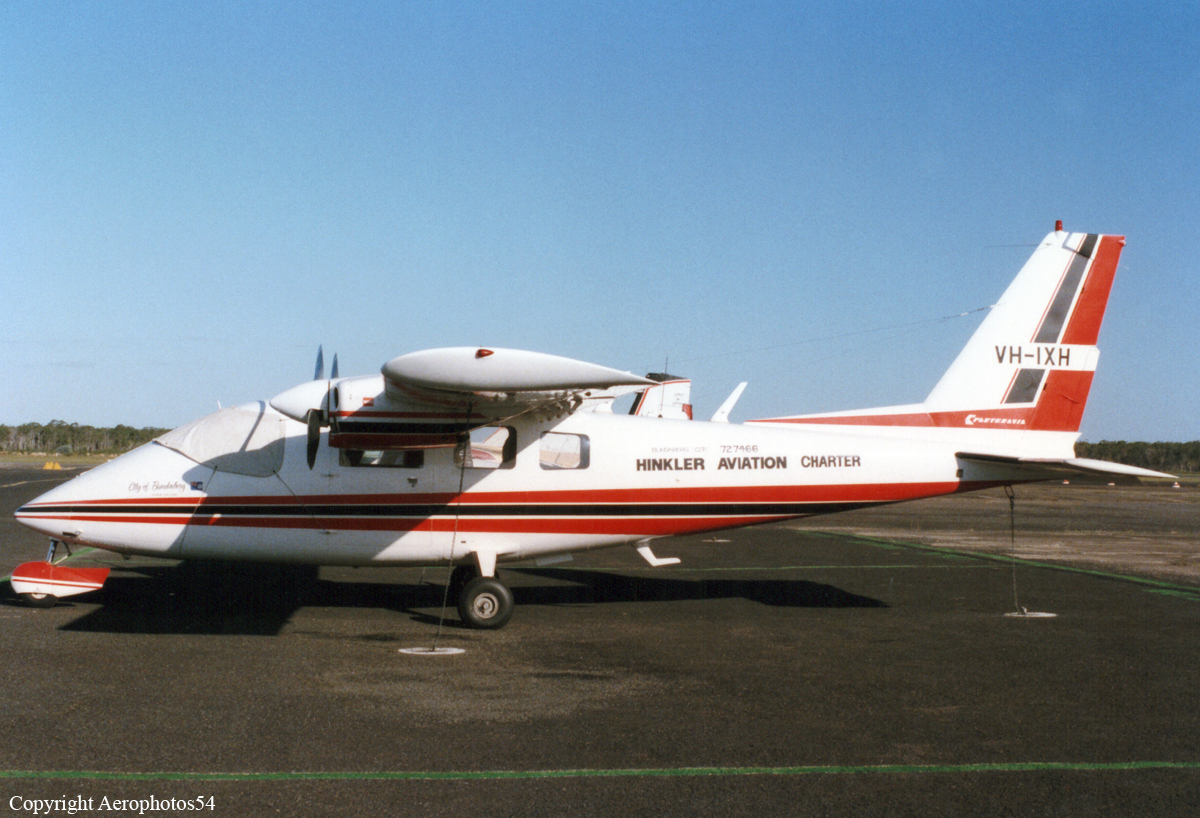
Crash of a Partenavia P.68B in Wagga Wagga: 2 killed

Date & Time: Jul 20, 1998 at 1739 LT
Type of aircraft:
Registration:
VH-IXH
Flight Type:
Survivors:
No
Schedule:
Corowa – Albury – Wagga Wagga
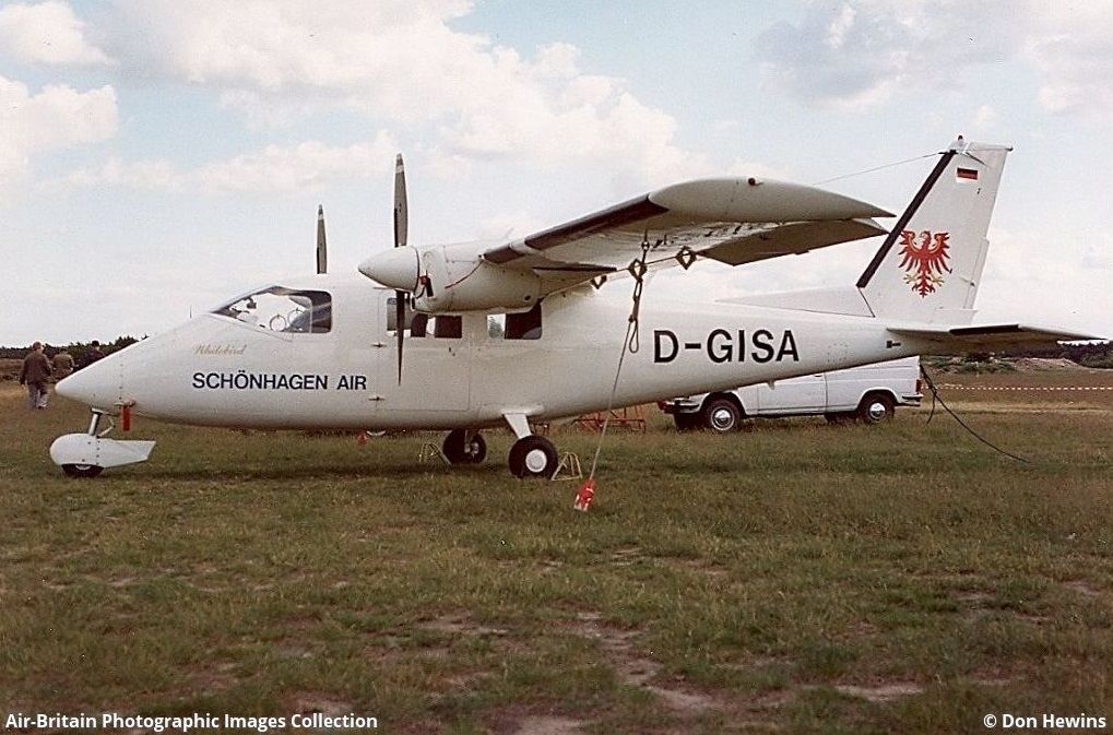
MSN:
186
YOM:
1979
Country:
Region:
Crew on board:
1
Crew fatalities:
Pax on board:
1
Pax fatalities:
Other fatalities:
Total fatalities:
2
Captain / Total flying hours:
1014
Captain / Total hours on type:
217.00
Circumstances:
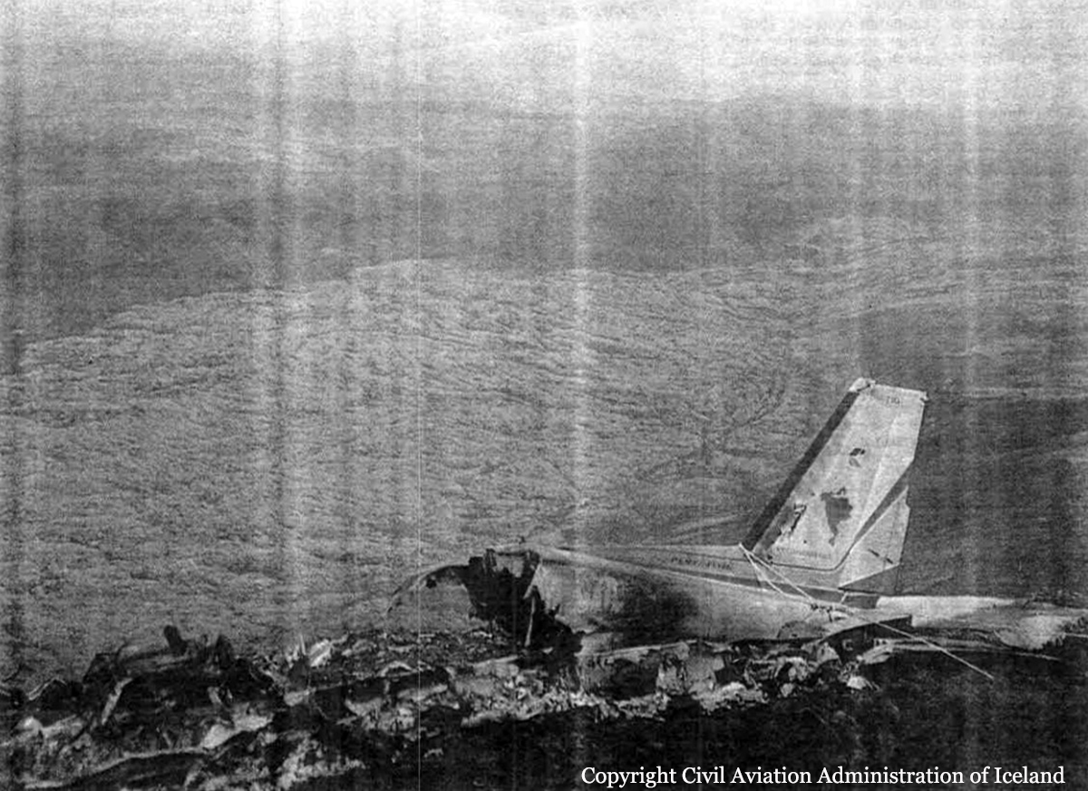
The aircraft operator had been contracted to provide a regular service transporting bank documents, medical pathology samples and items of general freight between Wagga Wagga, Albury and Corowa. On the day of the accident a passenger was accompanying the pilot for the day's flying. The pilot commenced the flight from Corowa to Albury under the Visual Flight Rules, flying approximately 500 ft above ground level. At Albury he obtained the latest aerodrome weather report for Wagga Wagga, which indicated that there was scattered cloud at 300 ft above ground level, broken cloud at 600 ft above ground level, visibility restricted to 2,000 m in light rain and a sea-level barometric pressure (QNH) of 1008 hPa. At 1715 Eastern Standard Time (EST) the aircraft departed Albury for Wagga Wagga under the Instrument Flight Rules. The pilot contacted the Melbourne en-route controller at 1728 and reported that he was maintaining 5,000 ft. Although the aircraft was operating outside controlled airspace, the en-route controller did have a radar surveillance capability and was providing the pilot with a flight information service. However, no return was recorded from the aircraft's transponder and at 1732 the pilot reported that he was transferring to the Wagga Wagga Mandatory Broadcast Zone frequency. This was the pilot's last contact with the controller. Although air traffic services do not monitor or record the Wagga Wagga Mandatory Broadcast Zone frequency, transmissions made on this frequency are recorded by AVDATA for the purpose of calculating aircraft landing charges. This information was reviewed following the accident. The pilot broadcast his position inbound to the aerodrome on the mandatory broadcast zone frequency and indicated that he was conducting a Global Positioning System (GPS) arrival. He established communication with the pilot of another inbound aircraft and at 9 NM from the aerodrome, broadcast his position as he descended through 2,900 ft. Approximately 1 minute and 20 seconds later, the pilot advised that he was passing 2,000 ft but immediately corrected this to state that he was maintaining 2,000 ft. He also stated that it was "getting pretty gloomy" and that according to the latest weather report he should be visual at the procedure's minimum descent altitude. The aircraft would have been approximately 6 NM from the aerodrome at this time. This was the last transmission heard from the pilot. The resident of a house to the south of Gregadoo Hill sighted the aircraft a short time before the accident. He was standing outside his house and stated that the aircraft was visible as it passed directly overhead at what appeared to be an unusually low height. The aircraft then disappeared into cloud that was obscuring Gregadoo Hill, approximately 350 m from where he was standing. Moments later he heard the sound of an impact followed almost immediately by a red flash of light. The noise from the engines appeared to be normal up until the sound of the impact. The aircraft had collided with steeply rising terrain on the southern face of Gregadoo Hill, approximately 40 ft below the crest. The hill is 4 NM from the aerodrome and is marked on instrument approach charts as a spot height elevation of 1,281 ft. The estimated time of the accident was 1739. The pilot and passenger sustained fatal injuries.
Probable cause:
The pilot had received an accurate appreciation of the weather conditions in the vicinity of Wagga Wagga prior to departing Albury. At that stage it would have been apparent that low cloud and poor visibility were likely to affect the aircraft's arrival. Under such conditions it would not have been possible to land from the GPS arrival procedure. As the reported cloud base and visibility were both below the minimum criteria, it is difficult to rationalise the pilot's transmission that, according to the latest weather report, he would be visual at the minimum descent altitude. This statement suggests that the pilot had already made the decision to continue his descent below the minimum altitude for the procedure and to attempt to establish visual reference for landing. Based on the report of broken low cloud in the vicinity of the aerodrome, the pilot would have needed to descend to 1,324 ft above mean sea level to establish the aircraft clear of cloud. This is within 50 ft of the last altitude recorded on the GPS receiver. Due to the difference between the actual and forecast QNH, the left altimeter would over-read by approximately 150 ft. At the time of the occurrence an otherwise correctly functioning instrument would have indicated an altitude of approximately 1,400 ft. The pilot had probably set the right altimeter to the local QNH prior to departing Albury. As this setting also corresponded to the actual QNH at Wagga Wagga, that instrument would have provided the more accurate indication of the aircraft's operating altitude. However, because of its location on the co-pilot's instrument panel, it is unlikely that the pilot would have included that altimeter in his basic instrument scan. It was not possible to assess the extent to which illicit drugs may have influenced the pilot's performance during the flight and affected his ability to safely operate the aircraft.
The following factors were identified:
- The pilot was operating the aircraft in instrument meteorological conditions below the approved minimum descent altitude.
- Low cloud was covering Gregadoo Hill at the time of the accident.
Final Report:

Crash of a Partenavia P.68B Victor in Schönhagen: 2 killed

Date & Time: Sep 20, 1996
Type of aircraft:
Registration:
D-GISA
Flight Type:
Survivors:
No
MSN:
105
YOM:
1977
Country:
Region:
Crew on board:
1
Crew fatalities:
Pax on board:
1
Pax fatalities:
Other fatalities:
Total fatalities:
2
Circumstances:
On final approach to Schönhagen Airport, the twin engine aircraft collided with trees and crashed in a wooded area short of runway. Both occupants were killed.

Crash of a Partenavia AP.68TP-300S Spartacus off El Segundo: 1 killed

Date & Time: Jan 9, 1996 at 0914 LT
Type of aircraft:
Operator:
Registration:
N3116C
Flight Phase:
Flight Type:
Survivors:
No
Schedule:
Oxnard - San Diego
MSN:
8007
YOM:
1987
Crew on board:
1
Crew fatalities:
Pax on board:
0
Pax fatalities:
Other fatalities:
Total fatalities:
1
Captain / Total flying hours:
8963
Captain / Total hours on type:
1000.00
Aircraft flight hours:
4540
Circumstances:
The aircraft was destroyed after an uncontrolled descent into the Pacific ocean about 14 miles west-southwest of El Segundo, California. The pilot was presumed to have been fatally injured. According to a company search pilot, visual meteorological conditions prevailed at the accident area about 1.5 hours after the time of the accident. No flight plan was filed for the positioning flight which originated at Oxnard, California, on the morning of the accident for a flight to San Diego, California. The aircraft departed Oxnard on a special VFR clearance. The tops of the clouds were reported to be about 1,200 feet msl. The aircraft transitioned southbound through the NAWS Point Mugu airspace. The Point Mugu radar approach control monitored the aircraft on radar for about 25 miles. The pilot was subsequently given a frequency change to SOCAL Tracon. There was no contact made with that facility. A search was initiated when the aircraft failed to arrive at the intended destination. A review of the recorded radar data revealed the aircraft was level at 1,800 feet msl and then climbed to about 2,000 feet msl, at which time it disappeared from radar.
Probable cause:
Loss of control for undetermined reasons.
Final Report:

Crash of a Partenavia P.68B in Tangalooma

Date & Time: Nov 22, 1995 at 2110 LT
Type of aircraft:
Registration:
VH-TLQ
Flight Phase:
Survivors:
Yes
Schedule:
Tangalooma – Coolangatta
MSN:
33
YOM:
1975
Country:
Region:
Crew on board:
1
Crew fatalities:
Pax on board:
4
Pax fatalities:
Other fatalities:
Total fatalities:
0
Captain / Total flying hours:
905
Captain / Total hours on type:
57.00
Circumstances:
The aircraft was the second to take off in a stream of six on a night flight from the Tangalooma Resort strip to Coolangatta aerodrome. Shortly after takeoff it struck the ground, nosed over and was consumed by a fuel-fed fire. The take-off run appeared normal but the initial climb was shallow according to the witnesses, some of whom were pilots waiting their turn to take off. At about 150 ft above ground level the aircraft entered a descent which continued until ground impact, 164 m beyond the departure end of the strip. The nose gear collapsed at impact but the aircraft remained upright and skidded along the ground on its main gear and front fuselage. It traversed a low sand dune, fell 10 ft to the beach and overturned. The aircraft came to rest 112 m beyond the first ground contact. All four passengers were able to evacuate the aircraft which had started to burn. The pilot was rescued by her passengers.
Probable cause:
The following factors were reported:
1. The takeoff direction was dark and had no visible horizon.
2. The elevator trim was not set for takeoff.
3. The elevator load on takeoff was high.
4. The pilot did not monitor the aircraft attitude after lift-off.
5. The flap was retracted in one movement, increasing the elevator load.
6. The pilot may have been affected by somatogravic illusion to the extent that she thought the climb attitude was adequate.
Final Report:

Crash of a Partenavia P.68C on Mt Geitarhilđ: 1 killed

Date & Time: Jun 30, 1995 at 1416 LT
Type of aircraft:
Operator:
Registration:
TF-VEN
Flight Phase:
Survivors:
No
Site:
Schedule:
Reykjavik - Selfoss
MSN:
284
YOM:
1983
Country:
Region:
Crew on board:
1
Crew fatalities:
Pax on board:
0
Pax fatalities:
Other fatalities:
Total fatalities:
1
Captain / Total flying hours:
800
Captain / Total hours on type:
15.00
Aircraft flight hours:
2824
Circumstances:
The twin engine aircraft departed Reykjavik Airport on a schedule flight to Selfoss, Southern Region. While flying under VFR mode in IMC conditions, the pilot failed to realize his altitude was too low when the aircraft struck the slope of Mt Geitarhilđ located near Lake Kleif, about 20 km south of Reykjavik. The aircraft was destroyed by impact forces and a post crash fire and the pilot, sole on board, was killed.
Probable cause:
Controlled flight into terrain.
Final Report:

Crash of a Partenavia P.68C-TC Victor in Kampenwand

Date & Time: Mar 13, 1995 at 0645 LT
Type of aircraft:
Operator:
Registration:
D-GITY
Flight Phase:
Flight Type:
Survivors:
Yes
Site:
Schedule:
Munich - Hanover
MSN:
362-42-TC
YOM:
1985
Country:
Region:
Crew on board:
1
Crew fatalities:
Pax on board:
4
Pax fatalities:
Other fatalities:
Total fatalities:
0
Circumstances:
While cruising by night, the pilot failed to realize his altitude was insufficient when the twin engine aircraft struck trees and crashed in a snow covered wooded area located in the Bavarian Alps, near Kampenwand. All five occupants were injured.

Crash of a Partenavia P.68C near Serres: 2 killed

Date & Time: Oct 10, 1994
Type of aircraft:
Operator:
Registration:
PH-VDO
Flight Phase:
Flight Type:
Survivors:
No
Site:
Schedule:
Cannes - Rotterdam
MSN:
354
YOM:
1984
Country:
Region:
Crew on board:
1
Crew fatalities:
Pax on board:
1
Pax fatalities:
Other fatalities:
Total fatalities:
2
Circumstances:
While cruising in poor visibility due to low clouds, the twin engine aircraft struck the slope of a mountain located near Serres. The wreckage was found a day later and both occupants were killed.

Crash of a Partenavia P.68B Victor in Bodmin

Date & Time: Feb 7, 1993 at 1345 LT
Type of aircraft:
Operator:
Registration:
G-LOUP
Flight Phase:
Flight Type:
Survivors:
Yes
Schedule:
Bodmin - Plymouth
MSN:
182
YOM:
1989
Location:
Region:
Crew on board:
1
Crew fatalities:
Pax on board:
1
Pax fatalities:
Other fatalities:
Total fatalities:
0
Captain / Total flying hours:
9531
Captain / Total hours on type:
210.00
Circumstances:
The aircraft was attempting to takeoff from the grass runway 32 at Bodmin, for a flight to Plymouth. The commander reported that the ground was soft and wet, with the grass surface longer than normal, and that no flap was selected. The flight manual for the aircraft stated that performance takeoffs should be carried out with 15° flap selected. The aircraft failed to achieve sufficient airspeed to become airborne in the distance available, and overran the runway into an area of thick gorse and moorland. There was no fire, and both occupants, who were wearing lap and diagonal shoulder harnesses, were uninjured, and vacated the aircraft by the normal means.
Final Report:

Crash of a Partenavia P.68B Victor in Kalundborg

Date & Time: Sep 28, 1991 at 1110 LT
Type of aircraft:
Operator:
Registration:
OY-CEW
Flight Phase:
Survivors:
Yes
Schedule:
Kalundborg - Kalundborg
MSN:
30
YOM:
1974
Country:
Region:
Crew on board:
1
Crew fatalities:
Pax on board:
6
Pax fatalities:
Other fatalities:
Total fatalities:
0
Circumstances:
The twin engine aircraft successfully completed three sortie in the morning. With six skydivers on board, the pilot prepared for a fourth mission when, during the takeoff roll, he realized he could not make it. He aborted the takeoff procedure and saw people at the end of the runway so he voluntarily veered off runway to the right. While contacting soft ground, the nose gear collapsed and the aircraft came to rest with its left wing partially torn off. All six passengers were evacuated safely while the pilot was slightly injured.
Probable cause:
Takeoff interruption on part of the pilot due to an insufficient speed. The exact cause of the mishap remains unclear.