Crash of a Partenavia P.68B in North Shore

Date & Time: Jul 20, 2001 at 0459 LT
Type of aircraft:
Operator:
Registration:
ZK-DMA
Flight Type:
Survivors:
Yes
Schedule:
Auckland-Whangarei
MSN:
68
YOM:
1976
Country:
Region:
Crew on board:
1
Crew fatalities:
Pax on board:
0
Pax fatalities:
Other fatalities:
Total fatalities:
0
Captain / Total flying hours:
706
Captain / Total hours on type:
200.00
Aircraft flight hours:
4773
Circumstances:
On Friday 20 July 2001, at around 0450, Partenavia P68B ZK-DMA was abeam North Shore Aerodrome at 5000 feet in darkness and enroute to Whangarei, when it suffered a double engine power loss. The pilot made an emergency landing on runway 21 at North Shore Aerodrome, but the aircraft overran the end of the runway, went through a fence, crossed a road and stopped in another fence. The pilot was the only person on board the aircraft and received face and ankle injuries. The aircraft encountered meteorological conditions conducive to engine intake icing, and ice, hail or sleet probably blocked the engine air intakes. The pilot had probably developed a mindset that dismissed icing as a cause, and consequently omitted to use alternate engine intake air, which should have restored engine power.
Probable cause:
The following findings were identified:
- The pilot was suitably qualified and authorised to conduct the flight.
- The aircraft was airworthy and its records indicated it had been maintained correctly.
- The aircraft encountered weather conditions conducive to the formation of engine intake icing.
- The engine air intakes probably became blocked by sleet, ice or hail, which caused both engines to lose power.
- The pilot probably developed a mindset that dismissed engine intake icing as a cause of the double engine power loss and omitted to apply the necessary corrective action.
- Had the pilot selected each engine’s alternate engine intake air on, engine power should have been restored.
- The Partenavia P68B flight manual warning concerning the use of alternate engine intake air should be amended to require the in-flight use of alternate air at ambient temperatures above freezing, in a high-humidity environment.
Final Report:

Crash of a Partenavia P.68C Victor in Ikorodu: 2 killed

Date & Time: Jun 16, 2001
Type of aircraft:
Registration:
5N-ATE
Flight Phase:
Survivors:
Yes
Schedule:
Lagos – Calabar
MSN:
244
YOM:
1981
Location:
Country:
Region:
Crew on board:
1
Crew fatalities:
Pax on board:
2
Pax fatalities:
Other fatalities:
Total fatalities:
2
Circumstances:
Few minutes after takeoff from Lagos-Murtala Muhammed Airport, en route to Calabar, the pilot informed ATC about engine problems and was cleared to return. He apparently attempted an emergency landing when the aircraft struck a tree and crashed in Igbogbo, in the southern suburb of Ikorodu, about 25 km east of Lagos Airport. A passenger was seriously injured while the pilot and the second passenger were killed.

Crash of a Partenavia P.68TC in Gratwich

Date & Time: Jun 3, 2001 at 1317 LT
Type of aircraft:
Operator:
Registration:
N33PV
Flight Phase:
Flight Type:
Survivors:
Yes
Schedule:
Meaux – Liverpool – Henstridge
MSN:
347-33/TC
YOM:
1984
Region:
Crew on board:
1
Crew fatalities:
Pax on board:
4
Pax fatalities:
Other fatalities:
Total fatalities:
0
Captain / Total flying hours:
695
Captain / Total hours on type:
159.00
Circumstances:
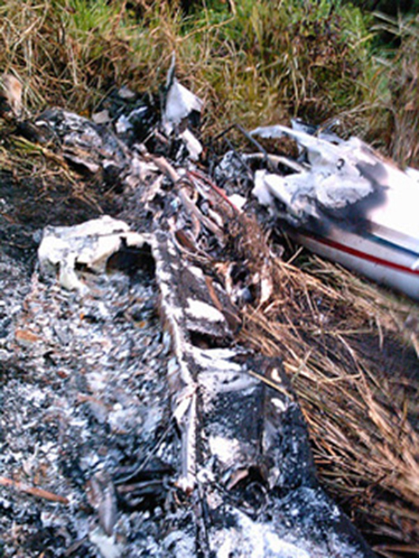
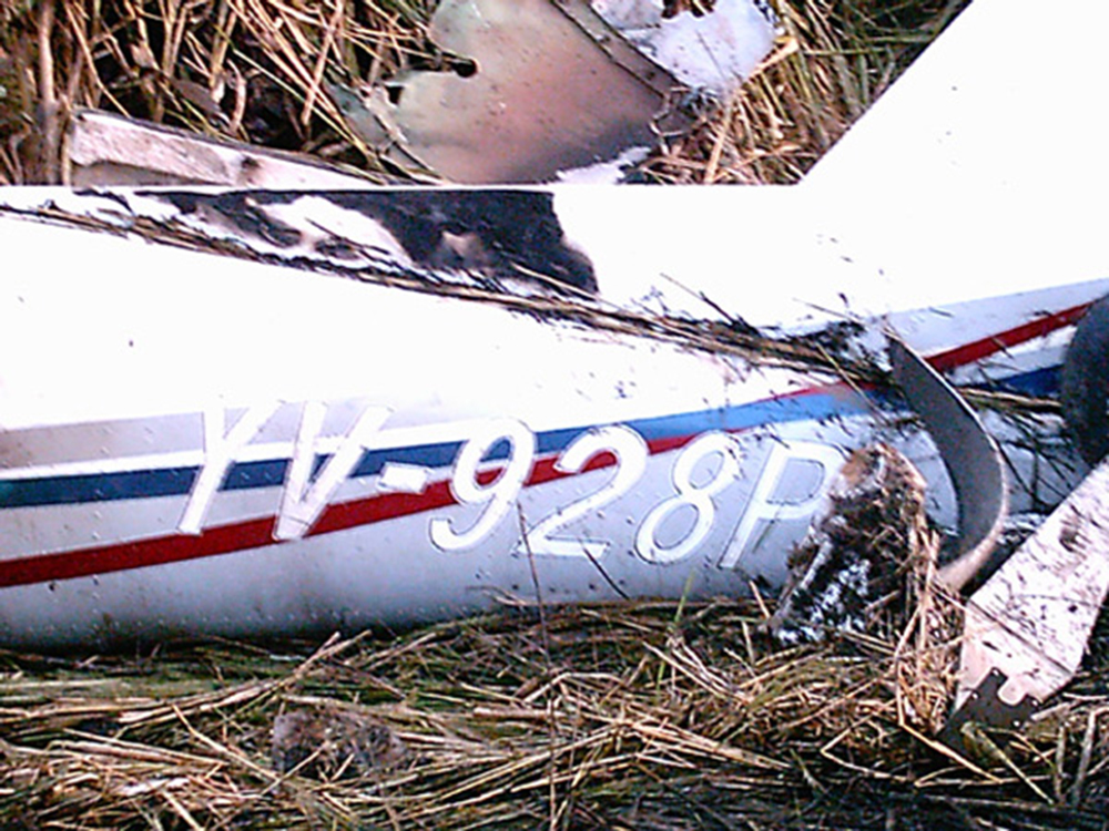
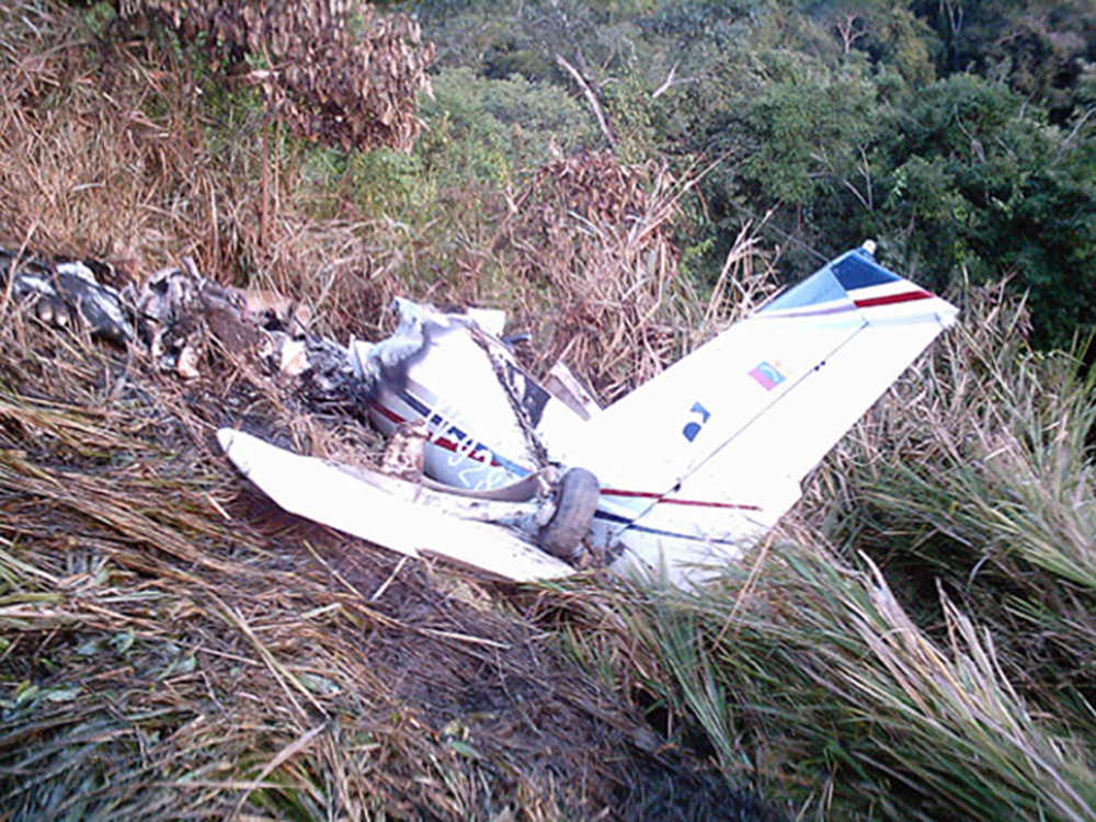
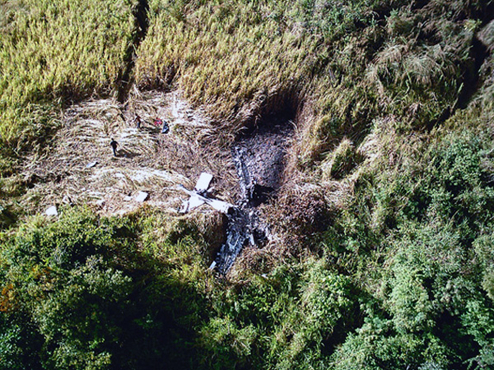
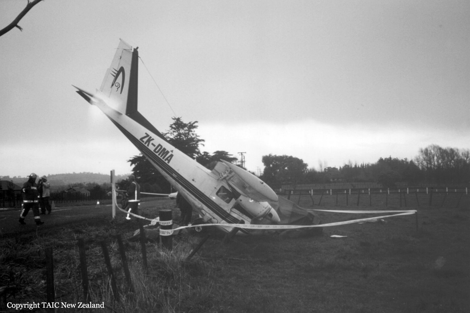
The five occupants left Guernsey on 24 May and flew direct to Vannes in Normandy. The pilot routinely cruised at power settings of 2,350 RPM and 32 inches Manifold Pressure giving a speed of 140 KIAS. The flight to Vannes would have taken some 44 minutes in still air and records recovered from the aircraft indicated that it lasted 50 minutes. The aircraft was parked at Vannes for a few days on level ground. No fuel was uplifted before leaving Vannes and the aircraft departed on 31 May to fly to Meaux on the eastern outskirts of Paris. The records indicate that this 254 nm flight lasted 2 hours 5 minutes. The aircraft was parked on level ground at Meaux for a few days. On the morning of 3 June, the day of the accident, the owner taxied the aircraft to the aero club's fuel pumps at Meaux to have the fuel tanks replenished. She believes she may have dipped the tanks before refuelling began but she could not remember the resultant quantities. Whilst the aircraft was being refuelled, the pilot left its vicinity and went into the club premises to file her flight plan, check the weather and pay the fuel and airport charges. The fuel receipt was completed for 157 litres of 100LL AVGAS When the refuelling operator had finished filling the left wing tank he moved towards the right wing but received instructions from a member of the pilot's family that there was no need to refuel the right wing tank. A different member of the family stated, soon after the accident, that this was because the right fuel tank gauge was indicating 2/3 full. Shortly afterwards the pilot returned to the aircraft. She did not dip the tanks after refuelling. On leaving Meaux the pilot recalled that the right tank gauge indicated "almost full" whilst the left tank gauge indicated "a bit less". Her intentions were to fly from Meaux to the airstrip near Liverpool where three persons would disembark and she would then return to Henstridge. There were no refuelling facilities at the Liverpool landing strip and she planned to complete both legs without refuelling. She did so on the basis that the aircraft's endurance on full tanks was about 6 hours and she planned to be airborne for less than this. (The still air flight time was later calculated to be 41/4 hours and the prevailing winds were westerly). The aircraft departed Meaux at 1020 hrs and was flown uneventfully and in VMC conditions towards Liverpool via Compiegne, Abbeville, Lydd, Clacton and Cambridge. The autopilot was disengaged throughout the flight and the pilot could not recall using abnormal amounts of rudder or roll control (the aircraft had no aileron trim). Specifically, she was not aware of any marked imbalance in roll or any abnormal fuel gauge readings. At 1246 hrs when the aircraft was at 3,500 feet altitude and south of Leicester the pilot contacted East Midlands Approach and requested a Flight Information Service en-route to the Lichfield NDB. At 1312 hrs she transmitted a Mayday message on the East Midlands frequency stating that she had "lost" the right engine. The controller responded with information that the nearest airfield was Tatenhill in her six o'clock at about 10 miles range. The pilot turned to the right and took-up a south-westerly track towards Tatenhill. About one minute later, when asked to confirm her altitude, the pilot reported "I HAVE NO ENGINES NOW" followed by "TO DO A FORCED LANDING PAPA VICTOR, OH NO ITS GOING AGAIN". The controller continued providing vectors to Tatenhill whilst his assistant briefed Tatenhill's radio operator and West Drayton's Distress and Diversion cell on the developing situation. At 1315:40 hrs, when the aircraft was 10 miles northwest of Tatenhill at 2,800 feet altitude, the pilot reported "NO ENGINES ... W'ELL HAVE TO FIND A FIELD". The last recorded RTF message from the pilot at 1316:50 hrs was "I HAVE A HI... HILL ERM A FIELD ON A". The pilot was heavily sedated in hospital for some time after the accident and she could remember little of the final stages of the glide approach. The aircraft passed low beside a farmhouse and crash-landed in a field of soft earth with a significant up-slope in the landing direction.
Probable cause:
The accident arose partly through significantly asymmetric fuel quantities in the two wing tanks before the aircraft took off. The pilot was critically injured in the accident and heavily sedated for some time afterwards, which may explain why she could remember few details of the refuelling process at Meaux. Because she left the aircraft during the refuelling operation, she may have been unaware that only the left tank had been replenished. A representative of the flying club at Meaux stated that the club accepted payment for fuel only by French cheque or in cash, and that the pilot paid in cash and appeared to spend all her remaining French currency. However, after paying all the charges at Meaux, the pilot's family had several hundred Francs and some French currency cheques with them and consequently, the inability to pay for more fuel was not an issue. Moreover, no explanation was offered as to how a pilot could pay for 157 litres of fuel before it had been delivered without the refueller receiving instructions to deliver that quantity. The pilot could not remember her instructions to the refueller but her instructions to a family member who remained with the aircraft were that if the left tank was between one half and two thirds full, the right tank was to be filled to within two inches of the filler neck. The pilot now believes that there may have been some confusion between the identification of 'left' and 'right' tanks. Nevertheless, if the fuel tank quantities were similar before the refuelling, it is surprising that the pilot was unaware of any tendency to roll towards the heavier left wing after take-off. Moreover, it is also surprising that the fuel gauges, which worked correctly when tested, did not give early warning of low fuel contents in one tank. The loss of power from the right engine was consistent with exhaustion of the fuel supply from the right wing tank which had not been replenished since the aircraft left Guernsey. Had it not been for the mis-positioned fuel selector valve, the pilot should have had ample fuel to land safely at Tatenhill on one engine, a procedure which she had been adequately trained to accomplish. This option was thwarted when air from the empty right tank reached the left engine. At that moment the left engine began to run intermittently and ultimately the pilot had no option but to execute a forced landing. The pilot chose a brown field in which to land because she feared the aircraft might turn over if she landed in a field of standing crop. The upward slope of the field, the soft earth and the 'clean' wing configuration all contributed to a very heavy forced landing. The pilot did not remember feathering the right propeller (it had been feathered) and she could not explain why she had touched down with the flaps retracted. Nevertheless, the tone of the pilot's voice on the radio suggested that she was coping well with an unpleasant and unforeseen situation. The East Midlands air traffic controller's performance was exemplary.
Final Report:

Crash of a Partenavia P.68B in Wagga Wagga: 2 killed

Date & Time: Jul 20, 1998 at 1739 LT
Type of aircraft:
Registration:
VH-IXH
Flight Type:
Survivors:
No
Schedule:
Corowa – Albury – Wagga Wagga
MSN:
186
YOM:
1979
Country:
Region:
Crew on board:
1
Crew fatalities:
Pax on board:
1
Pax fatalities:
Other fatalities:
Total fatalities:
2
Captain / Total flying hours:
1014
Captain / Total hours on type:
217.00
Circumstances:
The aircraft operator had been contracted to provide a regular service transporting bank documents, medical pathology samples and items of general freight between Wagga Wagga, Albury and Corowa. On the day of the accident a passenger was accompanying the pilot for the day's flying. The pilot commenced the flight from Corowa to Albury under the Visual Flight Rules, flying approximately 500 ft above ground level. At Albury he obtained the latest aerodrome weather report for Wagga Wagga, which indicated that there was scattered cloud at 300 ft above ground level, broken cloud at 600 ft above ground level, visibility restricted to 2,000 m in light rain and a sea-level barometric pressure (QNH) of 1008 hPa. At 1715 Eastern Standard Time (EST) the aircraft departed Albury for Wagga Wagga under the Instrument Flight Rules. The pilot contacted the Melbourne en-route controller at 1728 and reported that he was maintaining 5,000 ft. Although the aircraft was operating outside controlled airspace, the en-route controller did have a radar surveillance capability and was providing the pilot with a flight information service. However, no return was recorded from the aircraft's transponder and at 1732 the pilot reported that he was transferring to the Wagga Wagga Mandatory Broadcast Zone frequency. This was the pilot's last contact with the controller. Although air traffic services do not monitor or record the Wagga Wagga Mandatory Broadcast Zone frequency, transmissions made on this frequency are recorded by AVDATA for the purpose of calculating aircraft landing charges. This information was reviewed following the accident. The pilot broadcast his position inbound to the aerodrome on the mandatory broadcast zone frequency and indicated that he was conducting a Global Positioning System (GPS) arrival. He established communication with the pilot of another inbound aircraft and at 9 NM from the aerodrome, broadcast his position as he descended through 2,900 ft. Approximately 1 minute and 20 seconds later, the pilot advised that he was passing 2,000 ft but immediately corrected this to state that he was maintaining 2,000 ft. He also stated that it was "getting pretty gloomy" and that according to the latest weather report he should be visual at the procedure's minimum descent altitude. The aircraft would have been approximately 6 NM from the aerodrome at this time. This was the last transmission heard from the pilot. The resident of a house to the south of Gregadoo Hill sighted the aircraft a short time before the accident. He was standing outside his house and stated that the aircraft was visible as it passed directly overhead at what appeared to be an unusually low height. The aircraft then disappeared into cloud that was obscuring Gregadoo Hill, approximately 350 m from where he was standing. Moments later he heard the sound of an impact followed almost immediately by a red flash of light. The noise from the engines appeared to be normal up until the sound of the impact. The aircraft had collided with steeply rising terrain on the southern face of Gregadoo Hill, approximately 40 ft below the crest. The hill is 4 NM from the aerodrome and is marked on instrument approach charts as a spot height elevation of 1,281 ft. The estimated time of the accident was 1739. The pilot and passenger sustained fatal injuries.
Probable cause:
The pilot had received an accurate appreciation of the weather conditions in the vicinity of Wagga Wagga prior to departing Albury. At that stage it would have been apparent that low cloud and poor visibility were likely to affect the aircraft's arrival. Under such conditions it would not have been possible to land from the GPS arrival procedure. As the reported cloud base and visibility were both below the minimum criteria, it is difficult to rationalise the pilot's transmission that, according to the latest weather report, he would be visual at the minimum descent altitude. This statement suggests that the pilot had already made the decision to continue his descent below the minimum altitude for the procedure and to attempt to establish visual reference for landing. Based on the report of broken low cloud in the vicinity of the aerodrome, the pilot would have needed to descend to 1,324 ft above mean sea level to establish the aircraft clear of cloud. This is within 50 ft of the last altitude recorded on the GPS receiver. Due to the difference between the actual and forecast QNH, the left altimeter would over-read by approximately 150 ft. At the time of the occurrence an otherwise correctly functioning instrument would have indicated an altitude of approximately 1,400 ft. The pilot had probably set the right altimeter to the local QNH prior to departing Albury. As this setting also corresponded to the actual QNH at Wagga Wagga, that instrument would have provided the more accurate indication of the aircraft's operating altitude. However, because of its location on the co-pilot's instrument panel, it is unlikely that the pilot would have included that altimeter in his basic instrument scan. It was not possible to assess the extent to which illicit drugs may have influenced the pilot's performance during the flight and affected his ability to safely operate the aircraft.
The following factors were identified:
- The pilot was operating the aircraft in instrument meteorological conditions below the approved minimum descent altitude.
- Low cloud was covering Gregadoo Hill at the time of the accident.
Final Report:

Crash of a Partenavia P.68B Victor in Schönhagen: 2 killed

Date & Time: Sep 20, 1996
Type of aircraft:
Registration:
D-GISA
Flight Type:
Survivors:
No
MSN:
105
YOM:
1977
Country:
Region:
Crew on board:
1
Crew fatalities:
Pax on board:
1
Pax fatalities:
Other fatalities:
Total fatalities:
2
Circumstances:
On final approach to Schönhagen Airport, the twin engine aircraft collided with trees and crashed in a wooded area short of runway. Both occupants were killed.