Region

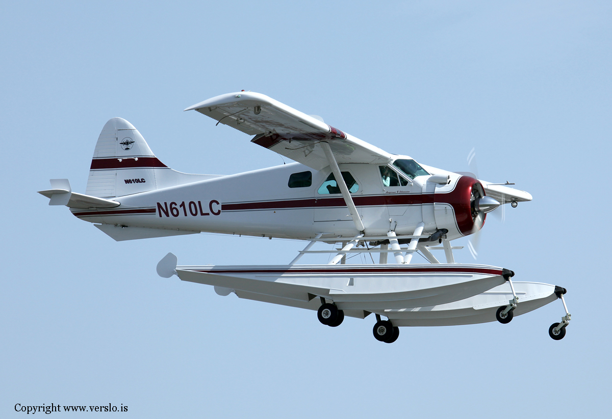
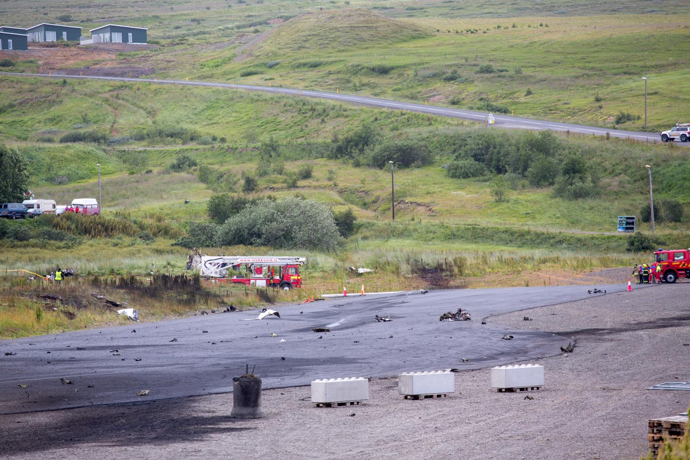
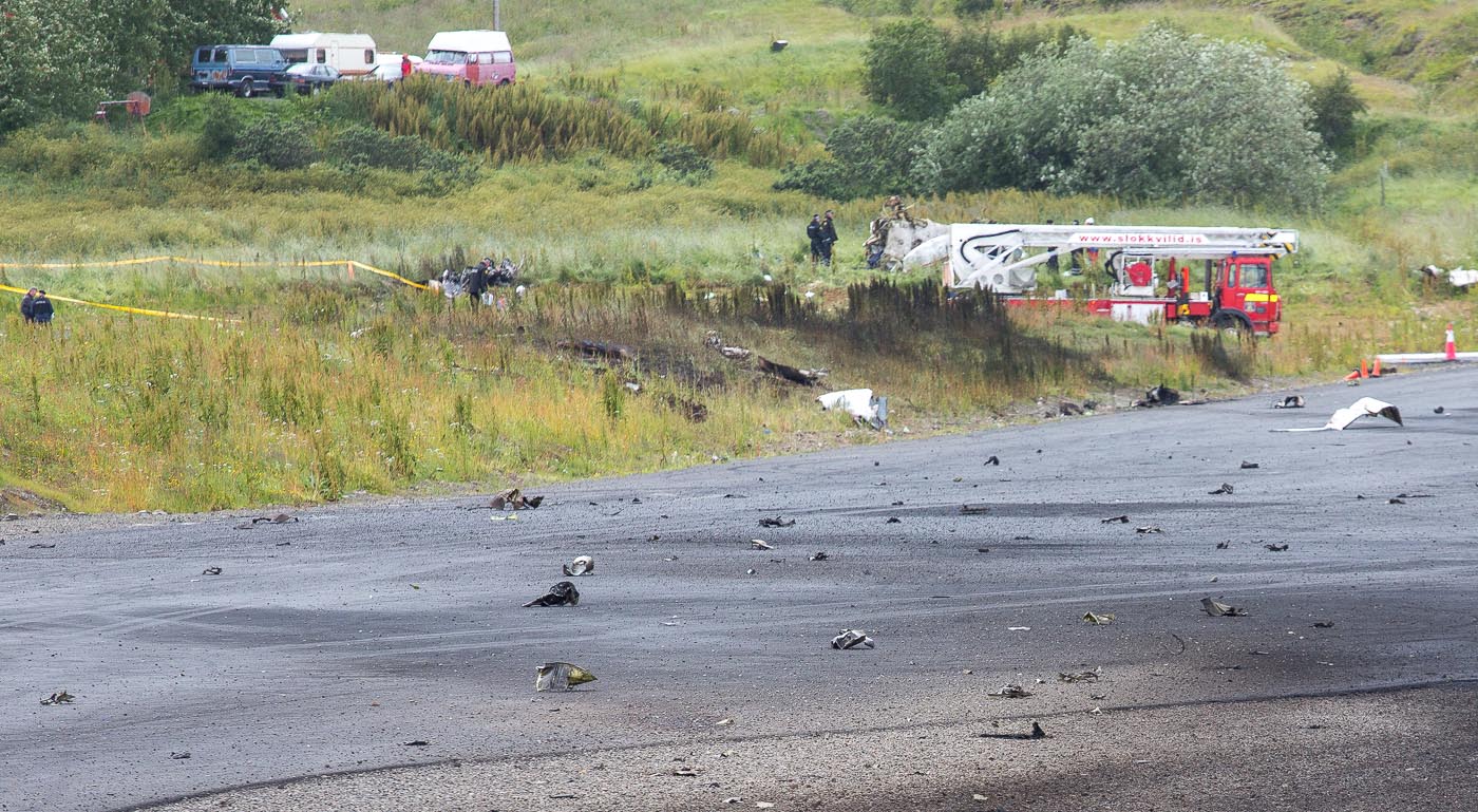
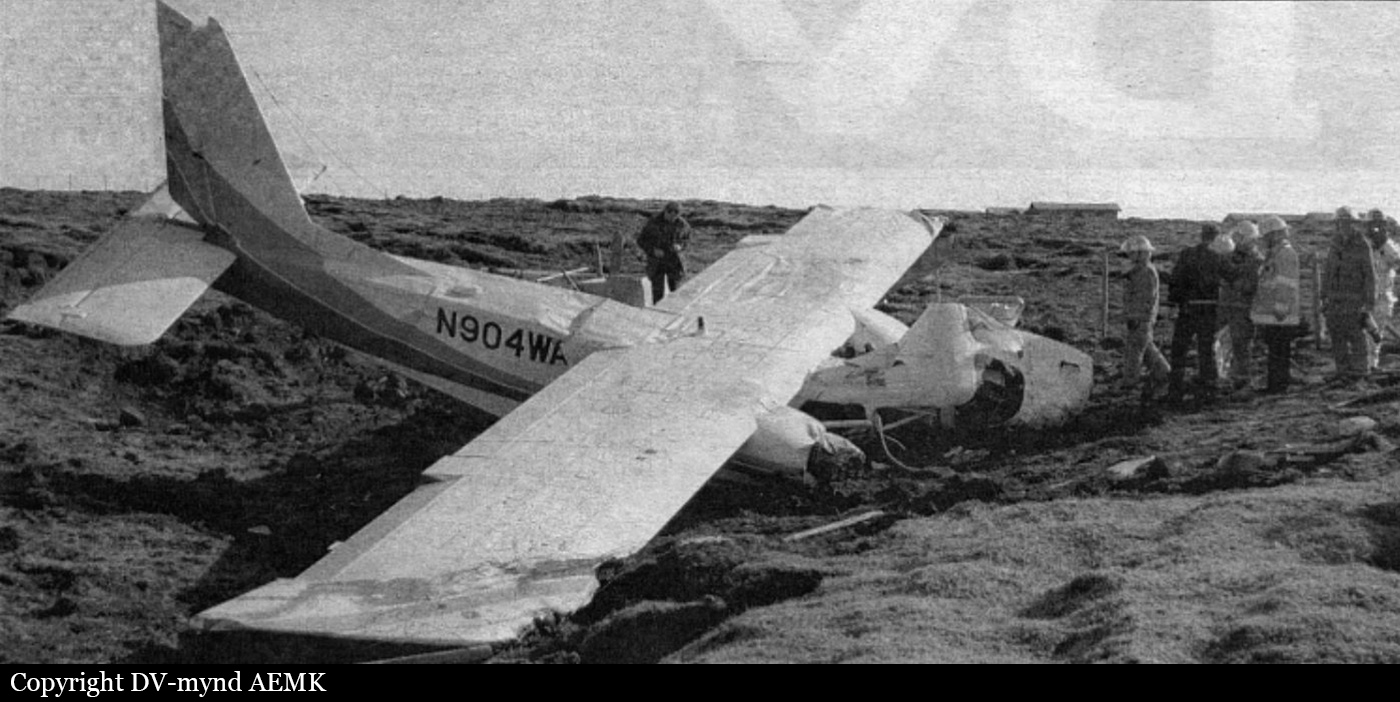
Crash of a De Havilland DHC-2 Beaver near Barkárdal: 1 killed

Date & Time: Aug 9, 2015 at 1445 LT
Type of aircraft:
Operator:
Registration:
N610LC
Flight Phase:
Flight Type:
Survivors:
Yes
Site:
Schedule:
Akureyri – Keflavik
MSN:
1446
YOM:
1960
Country:
Region:
Crew on board:
2
Crew fatalities:
Pax on board:
0
Pax fatalities:
Other fatalities:
Total fatalities:
1
Captain / Total flying hours:
22000
Captain / Total hours on type:
250.00
Circumstances:
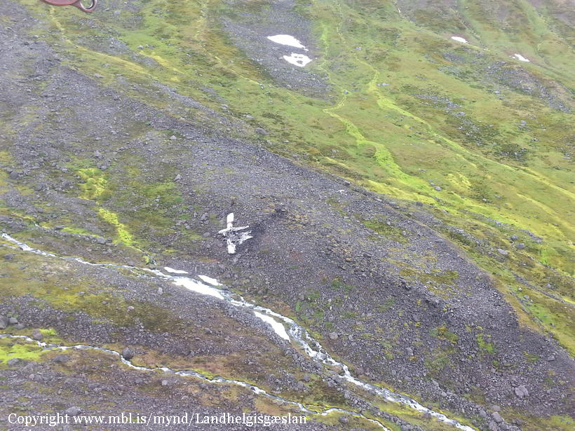
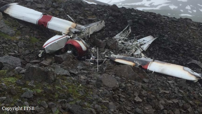
At 14:01 on August 9th, 2015, a pilot along with a friend, a contracted ferry flight pilot, planned to fly airplane N610LC, which is of the type De Havilland DHC-2 Beaver, under Visual Flight Rules (VFR) from Akureyri Airport to Keflavik Airport in Iceland. The purpose of the flight was to ferry the airplane from Akureyri to Minneapolis/St. Paul in the United States, where the airplane was to be sold. The airplane was initially flown in Eyjafjörður in a northernly direction from Akureyri, over Þelamörk and then towards and into the valley of Öxnadalur. The cloud ceiling was low and it was not possible to fly VFR flight over the heath/ridge of Öxnadalsheiði. The airplane was turned around in the head of the valley of Öxnadalur and flown towards the ridge of Staðartunguháls, where it was then flown towards the heath/ridge of Hörgárdalsheiði at the head of the valley of Hörgárdalur. In the valley of Hörgárdalur it became apparent that the cloud base was blocking off the heath/ridge of Hörgárdalsheiði, so the airplane was turned around again. The pilots then decided to fly around the peninsula of Tröllaskagi per their original backup plan, but when they reached the ridge of Staðartunguháls again the pilots noticed what looked like a break in the cloud cover over the head of the valley of Barkárdalur. A spontaneous decision was made by the pilots to fly into the valley of Barkárdalur. The valley of Barkárdalur is a long narrow valley with 3000 – 4500 feet high mountain ranges extending on either side. At the head of the valley of Barkárdalur there is a mountain passage at an elevation of approximately 3900 ft. About 45 minutes after takeoff the airplane crashed in the head of the valley of Barkárdalur at an elevation of 2260 feet. The pilot was severely injured and the ferry flight pilot was fatally injured in a post crash fire.
Probable cause:
Causes:
- According to the ITSB calculations the airplane was well over the maximum gross weight and the airplane’s performance was considerably degraded due to its overweight condition.
Weather
- VFR flight was executed, with the knowledge of IMC at the planned flight route across Tröllaskagi. The airplane was turned around before it entered IMC on two occasions and it crashed when the PF attempted to turn it around for the third time.
- Favorable weather on for the subsequent flight between Keflavik Airport and Greenland on August 10th may have motivated the pilots to fly the first leg of the flight in poor weather conditions on August 9th.
Terrain
- The pilots failed to take into account the geometry of the valley of Barkárdalur, namely its narrow width and the fast rising floor in the back of the valley.
Contributing factors:
CRM - Inadequate planning
- The W&B calculations performed by the PF prior to the flight were insufficient, as the airplane’s weight was well over the maximum gross weight of the airplane.
- The plan was to look for an opening (in the weather), first in the head of the valley of Öxnadalur, then the head of Hörgárdalur and finally in the head of Barkárdalur.
- The decision to fly into the valley of Barkárdalur was taken spontaneously, when flying out of the valley of Hörgárdalur and the pilots noticed what looked like a break in the cloud cover over the head of the valley of Barkárdalur.
CRM – Failed to conduct adequate briefing
- A failure of CRM occurred when the PNF did not inform the PF of the amount of fuel he added to the airplane prior to the flight.
Overconfidence
- The special ferry flight permit the pilots received for the ferry flight to Iceland in 2008 may have provided the pilots with a misleading assumption that such loading of the airplane in 2015 was also satisfactory.
Continuation bias
- The pilots were determined to continue with their plan to fly to Keflavik Airport, over the peninsula of Tröllaskagi, in spite of bad weather condition.
Loss of situational awareness
- The pilots were not actively managing the flight or staying ahead of the aircraft, taking into account various necessary factors including performance, weather and terrain.
- The airplane most likely incurred severe carburetor icing in Barkárdalur.
Final Report:

Crash of a Beechcraft B200 Super King Air in Akureyri: 2 killed

Date & Time: Aug 5, 2013 at 1329 LT
Operator:
Registration:
TF-MYX
Flight Type:
Survivors:
Yes
Schedule:
Reykjavik - Akureyri
MSN:
BB-1136
YOM:
1983
Country:
Region:
Crew on board:
2
Crew fatalities:
Pax on board:
1
Pax fatalities:
Other fatalities:
Total fatalities:
2
Captain / Total flying hours:
2600
Captain / Total hours on type:
1700.00
Copilot / Total flying hours:
2200
Copilot / Total hours on type:
1100
Aircraft flight hours:
15247
Aircraft flight cycles:
18574
Circumstances:
On 4th of August 2013 the air ambulance operator Mýflug, received a request for an ambulance flight from Höfn (BIHN) to Reykjavík Airport (BIRK). This was a F4 priority request and the operator, in co-operation with the emergency services, planned the flight the next morning. The plan was for the flight crew and the paramedic to meet at the airport at 09:30 AM on the 5th of August. A flight plan was filed from Akureyri (BIAR) to BIHN (positioning flight), then from BIHN to BIRK (ambulance flight) and from BIRK back to BIAR (positioning flight). The planned departure from BIAR was at 10:20. The flight crew consisted of a commander and a co-pilot. In addition to the flight crew was a paramedic, who was listed as a passenger. Around 09:50 on the 5th of August, the flight crew and the paramedic met at the operator’s home base at BIAR. The flight crew prepared the flight and performed a standard pre-flight inspection. There were no findings to the aircraft during the pre-flight inspection. The pre-flight inspection was finished at approximately 10:10. The departure from BIAR was at 10:21 and the flight to BIHN was uneventful. The aircraft landed at BIHN at 11:01. The commander was the pilot flying from BIAR to BIHN. The operator’s common procedure is that the commander and the co-pilot switch every other flight, as the pilot flying. The co-pilot was the pilot flying from BIHN to BIRK and the commander was the pilot flying from BIRK to BIAR, i.e. during the accident flight. The aircraft departed BIHN at 11:18, for the ambulance flight and landed at BIRK at 12:12. At BIRK the aircraft was refueled and departed at 12:44. According to flight radar, the flight from BIRK to BIAR was flown at FL 170. Figure 4 shows the radar track of the aircraft as recorded by Reykjavík Control. There is no radar coverage by Reykjavík Control below 5000 feet, in the area around BIAR. During cruise, the flight crew discussed the commander’s wish to deviate from the planned route to BIAR, in order to fly over a racetrack area near the airport. At the racetrack, a race was about to start at that time. The commander had planned to visit the racetrack area after landing. The aircraft approached BIAR from the south and at 10.5 DME the flight crew cancelled IFR. When passing KN locator (KRISTNES), see Figure 6, the flight crew made a request to BIAR tower to overfly the town of Akureyri, before landing. The request was approved by the tower and the flight crew was informed that a Fokker 50 was ready for departure on RWY 01. The flight crew of TF-MYX responded and informed that they would keep west of the airfield. After passing KN, the altitude was approximately 800’ (MSL), according to the co-pilot’s statement. The co-pilot mentioned to the commander that they were a bit low and recommended a higher altitude. The altitude was then momentarily increased to 1000’. When approaching the racetrack area, the aircraft entered a steep left turn. During the turn, the altitude dropped until the aircraft hit the racetrack.
Probable cause:
The commander was familiar with the racetrack where a race event was going on and he wanted to perform a flyby over the area. The flyby was made at a low altitude. When approaching the racetrack area, the aircraft’s calculated track indicated that the commander’s intention of the flyby was to line up with the racetrack. In order to do that, the commander turned the aircraft to such a bank angle that it was not possible for the aircraft to maintain altitude. The ITSB believes that during the turn, the commander most probably pulled back on the controls instead of levelling the wings. This caused the aircraft to enter a spiral down and increased the loss of altitude. The investigation revealed that the manoeuvre was insufficiently planned and outside the scope of the operator manuals and handbooks. The low-pass was made at such a low altitude and steep bank that a correction was not possible in due time and the aircraft collided with the racetrack. The ITSB believes that human factor played a major role in this accident. Inadequate collaboration and planning of the flyover amongst the flight crew indicates a failure of CRM. This made the flight crew less able to make timely corrections. The commander’s focus was most likely on lining up with the racetrack, resulting in misjudging the approach for the low pass and performing an overly steep turn. The overly steep turn caused the aircraft to lose altitude and collide with the ground. The co-pilot was unable to effectively monitor the flyover/low-pass and react because of failure in CRM i.e. insufficient planning and communication. A contributing factor is considered to be that the flight path of the aircraft was made further west of the airfield, due to traffic, resulting in a steeper turn. The investigation revealed that flight crews were known to deviate occasionally from flight plans.
Causal factors:
- A breakdown in CRM occurred.
- A steep bank angle was needed to line up with the racetrack.
- The discussed flyby was executed as a low pass.
- The maximum calculated bank angle during last phase of flight was 72.9°, which is outside the aircraft manoeuvring limit.
- ITSB believes that the commander’s focus on a flyby that he had not planned thoroughly resulted in a low-pass with a steep bank, causing the aircraft to lose altitude and collide with the ground.
Contributory factors:
- The commander’s attention to the activity at the race club area, and his association with the club was most probably a source of distraction for him and most likely motivated him to execute an unsafe maneuver.
- Deviations from normal procedures were seen to be acceptable by some flight crews.
- A flyby was discussed between the pilots but not planned in details.
- The flight crew reacted to the departing traffic from BIAR by bringing their flight path further west of the airport.
- The approach to the low pass was misjudged.
- The steep turn was most probably made due to the commander’s intention to line up with the race track.
Final Report:

Crash of a Dornier DO228-201 in Siglufjörður

Date & Time: Jun 23, 2004 at 1941 LT
Type of aircraft:
Operator:
Registration:
TF-ELH
Flight Type:
Survivors:
Yes
Schedule:
Sauðárkrókur - Siglufjörður
MSN:
8070
YOM:
1985
Country:
Region:
Crew on board:
2
Crew fatalities:
Pax on board:
0
Pax fatalities:
Other fatalities:
Total fatalities:
0
Captain / Total flying hours:
8400
Captain / Total hours on type:
2345.00
Copilot / Total flying hours:
1117
Copilot / Total hours on type:
253
Circumstances:
Following an uneventful passenger flight from Reykjavik to Sauðárkrókur, the crew decided to fly to Siglufjörður Airport to perform a competence control flight for this airfield. On approach in good weather conditions (visibility over 10 km with clouds at 1,500 feet), the captain disconnected the GPWS system to avoid repetitive alarms. After landing on runway 07, he attended to perform a touch-and-go so he increased engine power and took off. During initial climb, the landing gears were raised and the crew made a right hand turn circuit at an altitude of 500 feet. Following a second approach to runway 07, the aircraft landed on its belly and slid for 280 metres before coming to rest. Both pilots evacuated safely while the aircraft was damaged beyond repair.
Probable cause:
Belly landing after the crew failed to follow the approach checklist and failed to lower the landing gear for a second touch-and-go manoeuvre. The following contributing factors were identified:
- The crew failed to check that the three green lights were ON,
- The aircraft was unstable on final approach,
- The captain took over control without knowing how to proceed for the approach,
- The presence of birds in the vicinity of the runway disturbed the crew,
- The landing gear alert system was not properly set,
- The right hand circuit was completed at a low altitude of 500 feet.
Final Report:

Crash of a Rockwell Shrike Commander 500S off Vestmannaeyjar: 2 killed

Date & Time: Mar 6, 2001 at 0856 LT
Registration:
N272BB
Flight Phase:
Flight Type:
Survivors:
No
Schedule:
Keflavik – Stornoway
MSN:
500-3173
YOM:
1973
Country:
Region:
Crew on board:
2
Crew fatalities:
Pax on board:
0
Pax fatalities:
Other fatalities:
Total fatalities:
2
Captain / Total flying hours:
2456
Captain / Total hours on type:
120.00
Copilot / Total flying hours:
704
Copilot / Total hours on type:
13
Circumstances:
Two private pilots, citizens of the United States, who intended to participate in the “London - Sydney Air Race” set to take place 11 March to 7 April 2001, were operating the private aircraft, N272BB. The flight originated at Cape Cod in the United States and the aircraft was to be flown via Greenland, Iceland and Scotland to London, England, where the air-race was to commence. The aircraft arrived at Narsarsuaq, Greenland, on 4 March 2001 at 01:35 hrs. The next morning the pilots requested fuel and according to a statement by the Narsarsuaq airport personnel, 338 litres of LL100 avgas were put on the main fuel tanks that were filled. No fuel was put on the aircraft internal ferry-tank. The pilots received weather briefing and en-route information before departure and there was no anomalies noted by the airport personnel. The flight was planned at Fl-130 from Narsarsuaq, over the Greenland ice cap, to 62°N 040°W and then at FL110 to the border between the Greenland Soendrestrom Flight Information Region and the Reykjavik Flight Information Region. The takeoff from Narsarsuaq airport was at 14:29 hrs. The flight from Narsarsuaq Airport to Iceland was uneventful and the aircraft landed at Keflavik Airport Iceland at 18:59 hrs. Initially the pilots planned to continue the flight from Iceland that night but after studying the weather forecast they decided to stay overnight. At 19:50 hrs 447 litres of LL100 was put in the aircraft main tanks and the aircraft was then placed in a hangar. In the morning of 6 March 2001 the pilots arrived at Flight Operations Office at Keflavik Airport. The pilots were provided with current weather information and weather maps for the planned route and flight planning preparations for the flight to Stornoway, Scotland and onwards to London, England was completed. The plan was from Keflavik Airport (KEF) VOR, direct to ALDAN reporting point (62° 58' 49'' N 018° 45' 50'' W), direct to 61° N 012° 34' W, direct to 60° N 010° W, and direct to Stornoway. The flight level was 150 and the True Air Speed (TAS) was 145 kts. Prestwick in Scotland was filed as the alternate airport. The instrument flight plan was filed with the Air Traffic Control Centre in Reykjavik. The estimated flying time from KEF-VOR to ALDAN was 0:30 hrs, to 61° N 012° 34' W total 2:00 hrs and 02:30 hrs to 60° N 010° W. The planned time from Keflavik Airport to Stornoway was 4:00 hrs or the estimated time of arrival was at 12:19 hrs. The fuel endurance was given 10 hrs. The aircraft was cleared by ATC in accordance with the submitted instrument flight plan and assigned transponder code was 3575. The aircraft taxied out from the ramp at 08:08 hrs towards runway 11 and the take-off was at 08:19 hrs. After take-off the communication with Keflavik Approach Control was normal. The flight was then changed over to Reykjavik Area Control Centre (OACC) at 08:46 hrs and normal communication was established. The track to Aldan will take the aircraft overhead VM-NDB, 53 NM from KEF VOR, and then to Aldan, 120 NM from KEF VOR. Error was on the ATC slip indicating 30 minutes to Aldan. The controller changed that to 1:01, or estimate for Aldan at 09:20. The last communication with the crew took place at 08:49:50 when the aircraft was climbing slowly through about 14400 feet towards the planned cruising level, FL150. At 09:24:55 hrs Reykjavik OACC called N272BB in order to confirm the position, but there was no answer and repeated calls were in vain. The Shanwick Air Traffic Control Centre was notified at 09:29:15 hrs of the N272BB estimates and again at 09:38:01 hrs that ATC had lost contact with the aircraft. A subsequent replay of the ATC radar data showed that at 08:56 hrs the aircrafts target was lost from radar. The last plotted position was at 63° 32' 04'' N 020° 39' 36'' W, or about 8 NM from the south coast of Iceland. At 12:12 hrs a decision was taken to initiate a search in the area by available ships and fishing vessels in the area. An Icelandic Coast Guard helicopter was launched from Reykjavik into the search area at 12:32 hrs. At 13:49 hrs a debris from the missing aircraft and human remains were subsequently found floating on the ocean in a line spread north-westwards over a distance of about 5 NM from the point the target disappeared from radar. Both female pilots were killed.
Probable cause:
The following findings were identified:
- The aircraft was operated in overweight conditions,
- The flight departed Iceland into unfavourable weather conditions,
- The aircraft was climbing in icing conditions prior to it went out of control,
- The reason for the departure from a normal flight could not be positively determined,
- The aircraft went into an uncontrolled descent, followed by an overstress and possible in-flight break-up during an attempted recovery.
Final Report:

Crash of a Fairchild-Hiller FH-227B in Keflavik

Date & Time: Jul 26, 1998 at 2355 LT
Type of aircraft:
Operator:
Registration:
N564LE
Flight Type:
Survivors:
Yes
Schedule:
Billund - Aberdeen - Keflavik
MSN:
564
YOM:
1967
Country:
Region:
Crew on board:
2
Crew fatalities:
Pax on board:
0
Pax fatalities:
Other fatalities:
Total fatalities:
0
Circumstances:
On final approach, when the landing gears were extended, the crew heard loud cracking noise. The landing was aborted and the aircraft passed the tower for visual inspection and one of the crew went to the cabin for visual check of the landing gears where he observed that the right landing gear lock strut rear member had broken loose from the side member assembly and was hanging down. Upon touchdown the gear folded up and the aircraft right propeller, wing tip and bottom of the fuselage touched ground and the aircraft went off the runway in a gentle right turn. The fuselage bottom skin and frame structure sustained extensive damage and the right wing tip, propeller blades, lock strut assembly and drag strut were destroyed. The aircraft operated on a ferry flight from Billund, Denmark to Miami-Opa Locka, Florida, with en route stops at among others Aberdeen and Keflavík.
Probable cause:
Preliminary investigation revealed that no lubricant was found in the lock strut hinge pin that should normally be packed with grease.

Crash of a Piper PA-31-425 Pressurized Navajo in Reykjavik

Date & Time: Apr 22, 1997
Type of aircraft:
Operator:
Registration:
OY-AUT
Flight Type:
Survivors:
Yes
Schedule:
Reykjavik – Sondreströmfjord
MSN:
31-7400183
YOM:
1974
Country:
Region:
Crew on board:
1
Crew fatalities:
Pax on board:
0
Pax fatalities:
Other fatalities:
Total fatalities:
0
Circumstances:
Few minutes after takeoff from Reykjavik Airport, while cruising over Eyjafjallajökull, the pilote declared an emergency following the failure of the left engine. He was cleared to return to Reykjavik and was vectored for an approach to runway 14. On final, he encountered strong winds when the aircraft banked left then stalled and crashed 200 metres short of runway. The aircraft was damaged beyond repair and the pilot escaped uninjured. At the time of the accident, the wind was gusting from 100°-130° up to 35 knots.
Probable cause:
Engine failure for unknown reasons.

Crash of a Britten-Norman BN-2A-21 Islander near Keflavik

Date & Time: Mar 17, 1996 at 1212 LT
Type of aircraft:
Registration:
N904WA
Flight Type:
Survivors:
Yes
Schedule:
Reykjavik - Narsarsuaq
MSN:
904
YOM:
1981
Country:
Region:
Crew on board:
1
Crew fatalities:
Pax on board:
0
Pax fatalities:
Other fatalities:
Total fatalities:
0
Circumstances:
The pilot, sole on board, was completing a delivery flight from Europe to the US via Iceland and Greenland. Eight minutes after her departure from Reykjavik Airport, outbound to Narsarsuaq, the pilot informed ATC that her portable GPS fell on the ground and was not able to locate it. It such conditions, she decided to divert to Keflavik Airport when less than five minutes later, while descending, the right engine failed. For unknown reasons, she did not feather the propeller and did not elected to restart the engine. Due to drag and a loss of speed, the aircraft lost altitude and crashed near the village of Njarðvík, about 5 km east of Keflavik Airport. The aircraft was destroyed and the pilot was seriously injured.
Probable cause:
It was determined that the loss of power on the right engine was caused by the pilot who probably inadvertently reduced the mix ratio of the right engine while trying to find the portable GPS. For unknown reasons, she did not feather the propeller which increased drag and reduced speed and lift. A the time of the accident, the total weight of the aircraft was 297 kilos above MTOW, which was considered as a contributing factor.