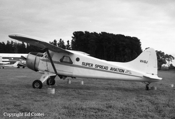
Crash of a De Havilland DHC-2 Beaver near Moulamein: 1 killed

Date & Time: Nov 15, 1971 at 0810 LT
Type of aircraft:
Operator:
Registration:
VH-IDJ
Flight Phase:
Survivors:
No
Schedule:
Dhuragoon - Dhuragoon
MSN:
1536
YOM:
1963
Country:
Region:
Crew on board:
1
Crew fatalities:
Pax on board:
0
Pax fatalities:
Other fatalities:
Total fatalities:
1
Captain / Total flying hours:
6700
Captain / Total hours on type:
4000.00
Circumstances:
The area to be seeded was a flooded rice paddy, rectangular in shape and approximately 1,650 feet east/west by 800 feet north/south, with the western bank 95 feet to the east of a river. There was an extensive area of dense timber, generally about 70 feet in height, on the western side of the river and a line of trees along the eastern bank. After making an aerial inspection of the area the pilot arranged for the two men who were to act as markers to take up positions on the banks of the paddy in preparation for easterly and westerly seeding runs commencing along the southern side. The first run was made into the east, approaching over the timbered area and towards the low sun. run was then made to the west followed by a steep pull-up and turn over the trees. The third run, again into the east, was commenced but no seed was dropped on this occasion possibly because of difficulties in observing and lining up with the marker at the western end of the paddy. The next run was to the west and was apparently normal and this was followed again by a steep pull-up and turn over the trees. Towards the end of the turn the aircraft was at an estimated height of 100 feet above the trees which was higher than on the previous turn in this area and may have resulted from an endeavour to observe each of the two markers in order to line up for the next run. The aircraft commenced a steep descent, with the wings level, consistent with an approach for a seeding run to the east. A few seconds later, when about 250 feet short of the rice paddy, the aircraft struck the sparsely foliated upper branches of a tree which extended about 20 feet above the other trees in the vicinity and the starboard elevator was torn off. With no apparent power reduction, and little change of direction, the aircraft rolled steeply to the left, descended and, after travelling a further 150 feet, struck another tree on the eastern side of the river. The wings and empennage were torn off and the fuselage fell through the tree to the ground and burst into flames.
Probable cause:
The evidence is insufficient for the cause of this accident to be determined but it is evident that the operation was being attempted in such a way as to allow little margin for error in the pilot's judgment of obstruction clearance.
Final Report:

Crash of a Douglas C-47B-25-DK in Townsville

Date & Time: Sep 6, 1971
Operator:
Registration:
A65-73
Flight Type:
Survivors:
Yes
MSN:
15923/32671
YOM:
1945
Country:
Region:
Crew on board:
0
Crew fatalities:
Pax on board:
0
Pax fatalities:
Other fatalities:
Total fatalities:
0
Circumstances:
Belly landed at Townsville Airport for unknown reasons. There were no casualties but the aircraft was damaged beyond repair.

Crash of a Fletcher FU-24 near Cowra: 1 killed

Date & Time: Mar 26, 1970 at 0730 LT
Type of aircraft:
Operator:
Registration:
VH-EOB
Flight Phase:
Survivors:
No
Schedule:
Cowra - Cowra
MSN:
45
YOM:
1957
Country:
Region:
Crew on board:
1
Crew fatalities:
Pax on board:
0
Pax fatalities:
Other fatalities:
Total fatalities:
1
Captain / Total flying hours:
2844
Captain / Total hours on type:
88.00
Circumstances:
The aircraft was spreading superphosphate in undulating country to the south of the Wyangala Dam. The section being treated was approximately one mile distant from the strip. The pilot had completed three sorties since commencing operations on the morning of the accident. After the fourth load had been spread, the aircraft was heard returning to the strip when the engine noise suddenly ceased and simultaneously a loud thud was heard by two loader drivers at the strip. The aircraft had crashed in the spreading area, striking the ground in a very steep nose down attitude. There were no witnesses to the flight path of the aircraft immediately prior to the impact and examination of the wreckage did not reveal any malfunction which may have caused or contributed to the accident.
Probable cause:
The cause of the accident has not been determined. A possible explanation is that the pilot attempted a turning manoeuvre from which he was unable to recover in the height available.
Final Report:

Crash of a Noorduyn Norseman off Sydney

Date & Time: Jan 18, 1970
Type of aircraft:
Registration:
VH-GSF
Flight Phase:
Survivors:
Yes
MSN:
270
YOM:
1943
Country:
Region:
Crew on board:
1
Crew fatalities:
Pax on board:
8
Pax fatalities:
Other fatalities:
Total fatalities:
0
Circumstances:
The engine failed and burst into flames during a skydiving display off Manly Beach, northeast of Sydney. Eight parachutists baled out, followed by pilot Ken Andrews (owner of Skyservice Aviation) at 5,000 feet who was wearing a parachute. As he floated down under his parachute the circling Norseman came very close to hitting him. All were rescued by boats. The Norseman struck the sea 6 miles off the beach, 5 miles southeast off Sydney Heads.
Souce: Geoff Goodall
Probable cause:
Engine failure in flight.

Crash of a Rockwell Shrike Commander 500S in Warracknabeal

Date & Time: May 6, 1969 at 1935 LT
Registration:
VH-EXT
Survivors:
Yes
Schedule:
Melbourne – Warracknabeal
Country:
Region:
Crew on board:
1
Crew fatalities:
Pax on board:
2
Pax fatalities:
Other fatalities:
Total fatalities:
0
Captain / Total flying hours:
5427
Captain / Total hours on type:
966.00
Circumstances:
At approximately 1935 hours EST on 6 May, 1969 an Aero Commander 500S aircraft, registered VH-EXT, struck the ground and crashed 2 miles west of Warracknabeal Aerodrome, Victoria, while making an approach to land at that aerodrome. The aircraft was owned and operated by Executive Air Services Pty. Ltd. of Melbourne and at the time of the accident it was engaged on a scheduled passenger commuter service between Essendon and Warracknabeal. The pilot, Allan James WALKER, and one passenger received minor injuries. A second passenger, the only other occupant, was seriously injured. The aircraft was virtually destroyed by impact forces. The pilot, aged 28 years, held a Current Commercial Pilot Licence, which was endorsed for the Aero Commander type of aircraft. He was the holder of a Class One Instrument Rating and this rating had been renewed after a flight test on 2 April, 1969. His total flying experience amounted to 5427 hours and of this, 966 hours had been flown on Aero Commander aircraft. He had recorded totals of 335 hours of instrument flying and 292 hours of night flying. The aircraft was operating under a current certificate of airworthiness and there is no evidence to indicate that the aircraft was other than in an airworthy condition. There is no evidence that the gross weight of the aircraft and the position of the centre of gravity were other than within the specified limits throughout the flight. The weather at Warracknabeal at the time of the accident was fine. There was no cloud and the wind was from the south east at 10 to 15 knots. The night visibility, that is, the distance at which prominent lighted objects could be seen and recognised, was reported to be 20 miles but it was a very dark night and there was virtually no visible horizon. The aircraft departed Essendon at 1836 hours using the procedures applicable to flight under the Instrument Flight Rules. The night to Warracknabeal at 6,500 feet was uneventful and the pilot commenced descent when the aircraft was approximately 40 miles from that destination. During the descent he observed the lights of the town of Warracknabeal and the lighting at the aerodrome. After entering the circuit the pilot commenced a downwind leg for a landing towards the east on runway 08. He made a left turn onto base leg and noted the indicated altitude as 1, 000 feet and at that altitude the clearance between the aircraft and the local terrain should have been slightly more than 600 feet. On the base leg of the circuit the pilot was unable to see the runway lights and being unsure of his position, he elected to conduct a go around. He did not retract the undercarriage, which had been extended earlier in preparation for landing, and the pilot continued the second circuit at 1, 000 feet indicated altitude rather than climbing to establish 1, 000 feet terrain clearance which would have been the normal procedure. He flew over the non-directional beacon, which is located approximately 300 yards north of the western end of the runway on which he intended to land arid he then positioned the aircraft for the downwind leg of the circuit.
Probable cause:
The probable cause of the accident was that the pilot, in approaching an aerodrome at night, did not use appropriate circuit procedures and did not make full use of the available visual and instrument information to ensure adequate terrain clearance.
Final Report:

Crash of a Vickers 720 Viscount near Port Hedland: 26 killed

Date & Time: Dec 31, 1968 at 1135 LT
Type of aircraft:
Operator:
Registration:
VH-RMQ
Flight Phase:
Survivors:
No
Schedule:
Perth – Port Hedland
MSN:
45
YOM:
1954
Flight number:
MV1750
Country:
Region:
Crew on board:
4
Crew fatalities:
Pax on board:
22
Pax fatalities:
Other fatalities:
Total fatalities:
26
Captain / Total flying hours:
19129
Captain / Total hours on type:
367.00
Copilot / Total flying hours:
2660
Copilot / Total hours on type:
143
Circumstances:
Flight 1750 was a scheduled domestic flight from Perth to Port Hedland in the State of Western Australia. Whilst taxiing for take-off on runway 02 at Perth Airport, the crew received and acknowledged an air traffic clearance communicated by Perth Tower. Of the alternative clearances offered, the pilot-in-command elected to proceed via the 030° radial of the Perth Very High Frequency Omni-Range (VOR), to Ballidu, whilst climbing to FL 170. Take-off was normal and the crew reported the departure time as 0836 hours Western Standard Time. At 0839 hours the pilot-in-command reported that he was climbing at an indicated airspeed of 155 kt, instead of the 175 kt proposed in the flight plan, because of turbulence which he first encountered at 1 500 ft. During this climb the co-pilot also advised Perth that the aircraft would continue its climb beyond the proposed FL 170 and cruise at FL 190. Apart from these minor changes to the flight plan the aircraft continued normally along the intended route with position reports being transmitted as scheduled to Perth Flight Service Centre, Meekatharra Flight Service Unit and Port Hedland Flight Service Centre. At 1114 hours the aircraft advised Port Hedland that it was abeam Wittenoom Gorge at FL 190 and that its estimated time of arrival at Port Hedland was 1142 hours. At 1120 hours the flight advised that it would be commencing its descent from FL 190 in three minutes and at 11-34 hours it reported that it was 30 miles by Distance Measuring Equipment south of Port Hedland-and had left 7 000 ft on descent. The flight service officer at Port Hedland acknowledged this message and transmitted the surface wind and temperature conditions and the altimeter setting for landing at Port Hedland. When this communication was not acknowledged further calls were made but no further communication from the aircraft was heard or recorded. At about the time that the aircraft failed to respond to the radio communication, two persons, each in different positions, saw the aircraft descending rapidly and steeply although these observations were made from distances of 44 and 64 miles respectively. Neither of these eyewitnesses was able to observe any impact with the ground because of intervening high terrain. At 1212 hours a Cessna 337 aircraft left Port Hedland to search along the route which the aircraft had been expected to follow and, eleven minutes later, the pilot of the search aircraft saw the burning wreckage of the Viscount aircraft, close to the intended route. Approximately one hour later a ground party from Port Hedland reached the scene of the accident. The location of the wreckage was later determined to be 28.1 miles on a bearing of 184' true from Port Hedland Airport. The aircraft was totally destroyed and none of the 26 occupants survived the crash.
Probable cause:
The cause of the accident was that the fatigue endurance of the starboard inner main spar lower boom was substantially reduced by the insertion of a flared bush at station 143 when the margin of safety associated with the retirement life specified for such booms did not ensure that this boom would achieve its retirement life in the presence of such a defect.
Final Report:

Crash of a De Havilland DH.104 Dove 5 in LOvely Banks

Date & Time: Nov 17, 1968
Type of aircraft:
Registration:
VH-CTS
Flight Type:
Survivors:
Yes
Schedule:
Lovely Banks - Lovely Banks
MSN:
04119
YOM:
1948
Country:
Region:
Crew on board:
2
Crew fatalities:
Pax on board:
0
Pax fatalities:
Other fatalities:
Total fatalities:
0
Captain / Total flying hours:
16200
Captain / Total hours on type:
400.00
Circumstances:
The crew was performing a local training flight at Lovely Banks Aerodrome, northwest of Geelong, Victoria. During the last segment, the level off was completed to high and the airplane struck the ground with its right main gear. Both occupants were uninjured but the aircraft was later considered as damaged beyond repair due to serious structure damages on the right wing.
Probable cause:
The instructor had little recent experience on the aircraft type and when demonstrating a landing in turbulent crosswind conditions, he leveled off too high. The right wing dropped and aircraft landed heavily on one wheel while drift was still present. The main spar was damaged and a wing displaced rearwards.

Crash of a De Havilland DH.83 Fox Moth off Carlisle Island

Date & Time: Aug 1, 1968
Registration:
VH-UAL
Flight Phase:
Flight Type:
Survivors:
Yes
MSN:
4039
YOM:
1933
Country:
Region:
Crew on board:
1
Crew fatalities:
Pax on board:
0
Pax fatalities:
Other fatalities:
Total fatalities:
0
Circumstances:
While flying at an altitude of 1,300 feet, the pilot encountered atmospheric turbulences. The airplane initiated an uncontrolled descent until it struck the water surface off Carlisle Island. The pilot was rescued while the airplane sank and was lost.
Probable cause:
Loss of control caused by downdrafts and turbulences.

Crash of a Noorduyn Norseman in Armidale

Date & Time: Sep 26, 1966
Type of aircraft:
Registration:
VH-GSE
Flight Phase:
Survivors:
Yes
Schedule:
Armidale - Armidale
MSN:
249
YOM:
1943
Country:
Region:
Crew on board:
1
Crew fatalities:
Pax on board:
0
Pax fatalities:
Other fatalities:
Total fatalities:
0
Captain / Total flying hours:
8500
Captain / Total hours on type:
2000.00
Circumstances:
The pilot Colin Pay was involved in a local crop dusting operations. On takeoff, the airplane struck a fence and a tractor then crashed inverted in flames. The pilot was unhurt while the aircraft was destroyed.
Probable cause:
The aircraft failed to climb away after becoming airborne and struck the ground again on its main wheels in a gully. On becoming airborne again it struck the top strand of a wire fence then alighted on the main wheels in a rock-strewn paddock, collided with a tractor, overturned and was destroyed by fire.

Crash of a Lockheed L-414-08 Hudson IVA in Tennant Creek: 6 killed

Date & Time: Sep 24, 1966 at 0915 LT
Type of aircraft:
Operator:
Registration:
VH-AGE
Flight Type:
Survivors:
No
Schedule:
Tennant Creek - Tennant Creek
MSN:
414-6039
YOM:
1941
Country:
Region:
Crew on board:
1
Crew fatalities:
Pax on board:
5
Pax fatalities:
Other fatalities:
Total fatalities:
6
Circumstances:
The aircraft had been carrying out magnetometer survey flights from the airport for several weeks. It departed at 06:30 hours local time, reaching the survey area an hour later. At 07:50 the Doppler equipment became unserviceable and a little later light rain was encountered. The survey work was abandoned and the flight returned to Tennant Creek. At 09:14 the crew radioed that they were in the circuit area. Wind was reported to be from 070° at 14 knots. The acknowledgement of this information was the last contact with the flight. A minute later, the twin engine aircraft crashed in a prairie located 2 miles west of the runway 07 threshold.The aircraft was totally destroyed and all six on board were killed, among them a child aged 11. An examination of wreckage showed that one of the duplicated aileron control chains in the pilot's control column was broken in the region of the control wheel sprocket. A link pin had failed and this pin might have subsequently jammed the assembly as the control wheel was being rotated. Control could not be taken over by the copilot, as there was no copilot on the flight. The right hand cockpit seat and rudder pedals were removed so a crew member was able to gain access to the nose area of the aircraft for the survey work.
Probable cause:
The cause of this accident was a loss of control of the aircraft, and although the evidence available does not permit the reason for the loss of control to be determined, the possibility can not be eliminated that the pilot suffered an impairment of ability and, coincidentally, was deprived temporarily of aileron control.