Zone

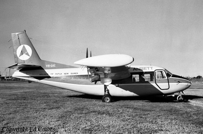
Crash of a Piaggio P.166AL-1 Albatross near Marulan: 1 killed

Date & Time: Feb 22, 1977 at 0755 LT
Type of aircraft:
Operator:
Registration:
VH-GOC
Flight Phase:
Flight Type:
Survivors:
No
Site:
Schedule:
Bankstown - Warracknabeal
MSN:
403
YOM:
1961
Country:
Region:
Crew on board:
1
Crew fatalities:
Pax on board:
0
Pax fatalities:
Other fatalities:
Total fatalities:
1
Captain / Total flying hours:
12000
Captain / Total hours on type:
1200.00
Circumstances:
The pilot attended the Bankstown Briefing Office at about 0600 hours. He was briefed concerning the current weather conditions at Bankstown Airport, which were Instrument Meteorological Conditions (IMC) but were Improving to VMC; and the relevant meteorological forecasts which indicated, for his proposed route, that he might experience some difficulty in maintaining flight In Visual Meteorological Conditions (VMC). The pilot's licence was not endorsed to permit him to operate in other than VMC. He then submitted a flight plan for a flight from Bankstown Airport to Warracknabeal and return, proceeding over Marulan the estimated time interval thereto being 33 minutes, the flight to be conducted in accordance with the Visual Flight Rules (VFR) at altitudes not exceeding 5000 feet. The aircraft departed Bankstown Airport, in VMC, and established two way communication with Sydney Flight Service Unit (FSU). At 0748 hours the pilot advised the Sydney FSU that he was "returning to Camden, estimating Camden at one five". In response to a query the pilot advised "weather okay". No further communications were received from the aircraft. At about 0755 hours the aircraft was heard and observed flying in an easterly direction some 20 kilometres north-northeast of Marulan. There was low cloud and some light rain in the area. The aircraft was flying below the cloud base and was at a height of 500 feet to 200 feet above undulating terrain, proceeding towards rugged terrain which was gradually rising. Subsequently the aircraft proceeded over a ridge line out of the sight of witnesses. Shortly thereafter the engine noise ceased abruptly. The police were alerted and search and rescue action was initiated. The wreckage of the aircraft was located some eight hours later. The aircraft had crashed on a heavily timbered 12 degree upslope about 100 feet below a ridge line. At Impact the aircraft was in a nose down attitude and was banked some 45 degrees to the right. The right hand propeller was feathered and the engine had not been operating at impact. The left hand engine had been under power. The landing gear and flaps had been fully retracted. The available evidence Indicates that the gross weight of the aircraft was at or about the maximum permissible all up weight. Examination of the right hand engine revealed massive internal failure which had commenced with the failure of the right hand dowel In the Number 2 main crankcase bearing. It is probable that the dowel failed because of abnormal loads resulting from loss of bearing nip associated with crankcase fretting at the lower through bolt of the Number 2 bearing saddle. It is estimated that the engine had operated some 170 hours since issue of the last maintenance release on 26 October 1976.
Probable cause:
The probable cause of the accident was that, in the conditions pertaining, the single engine performance of the aircraft was insufficient to ensure maintenance of adequate terrain clearance whilst flying over undulating terrain at a low eight. Internal structural failure of right hand engine, Lycomtng GSO480-BIC6 Serial number L3050-33. Left hand engine carburettor air temperature control valve detached from actuating shaft.
Final Report:

Crash of a Rockwell Shrike Commander 500S in Warracknabeal

Date & Time: May 6, 1969 at 1935 LT
Registration:
VH-EXT
Survivors:
Yes
Schedule:
Melbourne – Warracknabeal
Country:
Region:
Crew on board:
1
Crew fatalities:
Pax on board:
2
Pax fatalities:
Other fatalities:
Total fatalities:
0
Captain / Total flying hours:
5427
Captain / Total hours on type:
966.00
Circumstances:
At approximately 1935 hours EST on 6 May, 1969 an Aero Commander 500S aircraft, registered VH-EXT, struck the ground and crashed 2 miles west of Warracknabeal Aerodrome, Victoria, while making an approach to land at that aerodrome. The aircraft was owned and operated by Executive Air Services Pty. Ltd. of Melbourne and at the time of the accident it was engaged on a scheduled passenger commuter service between Essendon and Warracknabeal. The pilot, Allan James WALKER, and one passenger received minor injuries. A second passenger, the only other occupant, was seriously injured. The aircraft was virtually destroyed by impact forces. The pilot, aged 28 years, held a Current Commercial Pilot Licence, which was endorsed for the Aero Commander type of aircraft. He was the holder of a Class One Instrument Rating and this rating had been renewed after a flight test on 2 April, 1969. His total flying experience amounted to 5427 hours and of this, 966 hours had been flown on Aero Commander aircraft. He had recorded totals of 335 hours of instrument flying and 292 hours of night flying. The aircraft was operating under a current certificate of airworthiness and there is no evidence to indicate that the aircraft was other than in an airworthy condition. There is no evidence that the gross weight of the aircraft and the position of the centre of gravity were other than within the specified limits throughout the flight. The weather at Warracknabeal at the time of the accident was fine. There was no cloud and the wind was from the south east at 10 to 15 knots. The night visibility, that is, the distance at which prominent lighted objects could be seen and recognised, was reported to be 20 miles but it was a very dark night and there was virtually no visible horizon. The aircraft departed Essendon at 1836 hours using the procedures applicable to flight under the Instrument Flight Rules. The night to Warracknabeal at 6,500 feet was uneventful and the pilot commenced descent when the aircraft was approximately 40 miles from that destination. During the descent he observed the lights of the town of Warracknabeal and the lighting at the aerodrome. After entering the circuit the pilot commenced a downwind leg for a landing towards the east on runway 08. He made a left turn onto base leg and noted the indicated altitude as 1, 000 feet and at that altitude the clearance between the aircraft and the local terrain should have been slightly more than 600 feet. On the base leg of the circuit the pilot was unable to see the runway lights and being unsure of his position, he elected to conduct a go around. He did not retract the undercarriage, which had been extended earlier in preparation for landing, and the pilot continued the second circuit at 1, 000 feet indicated altitude rather than climbing to establish 1, 000 feet terrain clearance which would have been the normal procedure. He flew over the non-directional beacon, which is located approximately 300 yards north of the western end of the runway on which he intended to land arid he then positioned the aircraft for the downwind leg of the circuit.
Probable cause:
The probable cause of the accident was that the pilot, in approaching an aerodrome at night, did not use appropriate circuit procedures and did not make full use of the available visual and instrument information to ensure adequate terrain clearance.
Final Report: