Country
code

Tasmania

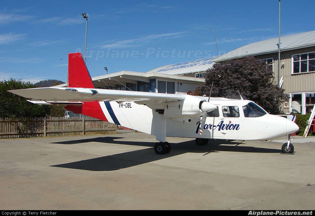
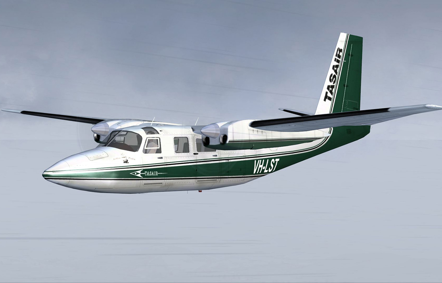
Crash of a Britten-Norman BN-2A-20 Islander in West Portal: 1 killed

Date & Time: Dec 8, 2018 at 0828 LT
Type of aircraft:
Operator:
Registration:
VH-OBL
Flight Phase:
Flight Type:
Survivors:
No
Site:
Schedule:
Cambridge – Bathurst Harbour
MSN:
2035
YOM:
1986
Country:
Region:
Crew on board:
1
Crew fatalities:
Pax on board:
0
Pax fatalities:
Other fatalities:
Total fatalities:
1
Captain / Total flying hours:
540
Captain / Total hours on type:
80.00
Aircraft flight hours:
12428
Circumstances:
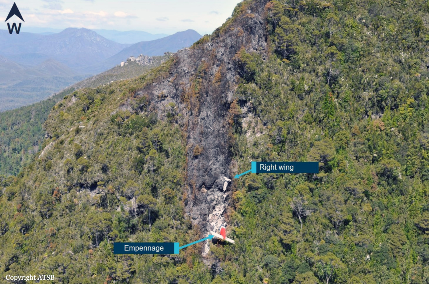
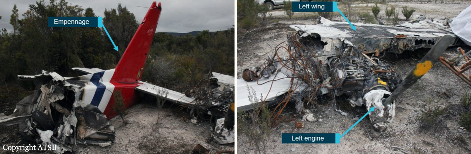
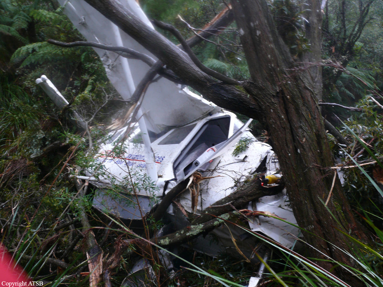
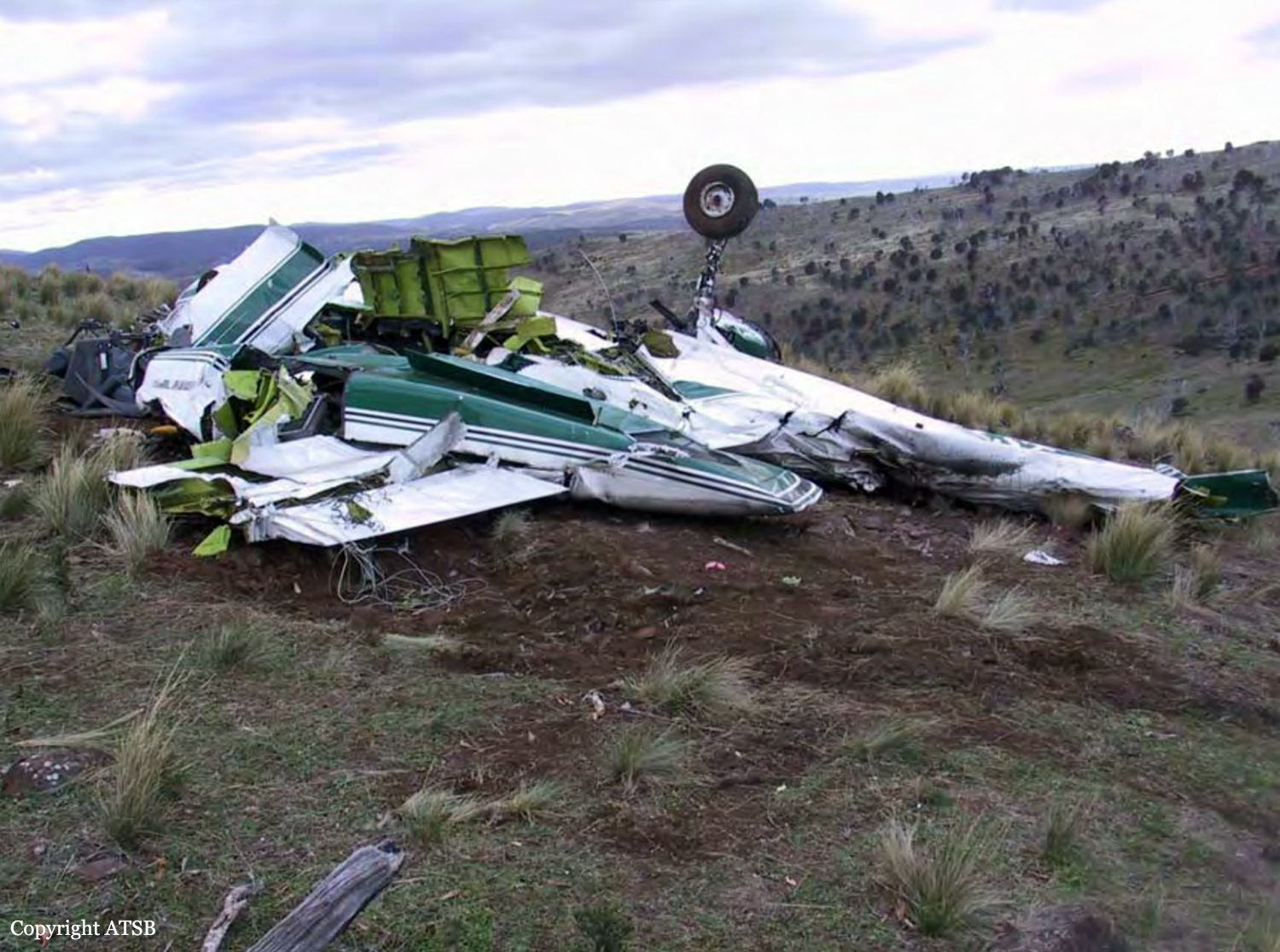
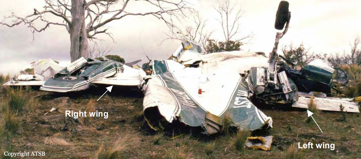
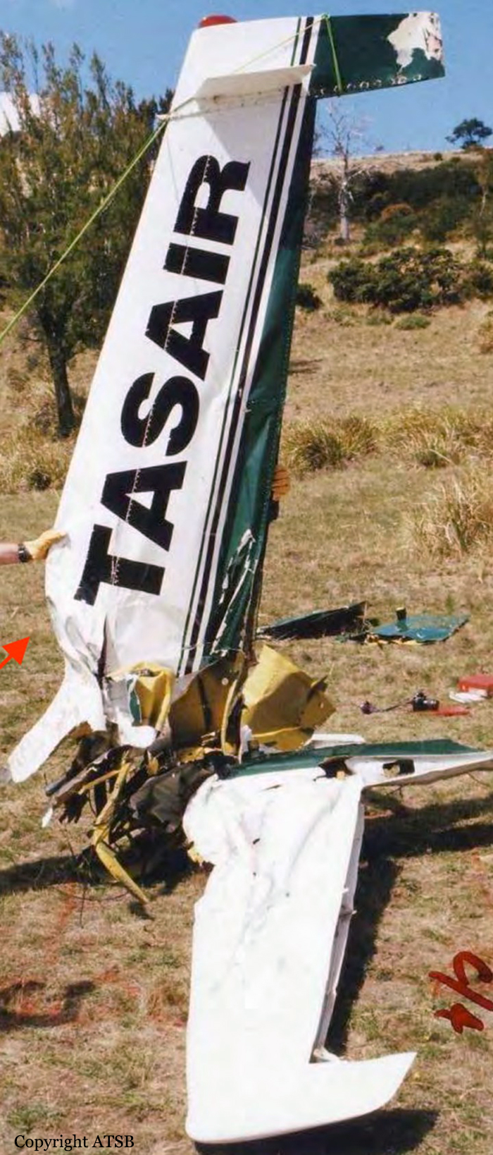
On 8 December 2018, the pilot of a Pilatus Britten-Norman BN2A-20 Islander, registered VH-OBL and operated by Airlines of Tasmania, was conducting a positioning flight under the visual flight rules from Cambridge Airport to the Bathurst Harbour aeroplane landing area (ALA), Tasmania. The aircraft departed Cambridge at about 0748 Eastern Daylight-saving Time and was scheduled to arrive at Bathurst Harbour about 0830 to pick up five passengers for the return flight. The passengers were part of a conservation project that flew to south-west Tasmania regularly, and it was the pilot’s only flight for that day. Automatic dependent surveillance broadcast (ADS-B) position and altitude data (refer to the section titled Recorded information) showed the aircraft tracked to the south-west towards Bathurst Harbour (Figure 1). At about 0816, the aircraft approached a gap in the Arthur Range known as ‘the portals’. The portals are a saddle (lowest area) between the Eastern and Western Arthur Range, and was an optional route that Airlines of Tasmania used between Cambridge and Bathurst Harbour when the cloud base prevented flight over the mountain range. After passing through the portals, the aircraft proceeded to conduct a number of turns below the height of the surrounding highest terrain. The final data point recorded was at about At about 0829, the Australian Maritime Safety Authority received advice that an emergency locator transmitter allocated to VH-OBL had activated. They subsequently advised the Tasmanian Police and the aircraft operator of the activation, and initiated search and rescue efforts. The rescue efforts included two helicopters and a Challenger 604 search and rescue jet aircraft. The Challenger arrived over the emergency locator transmitter signal location at around 0925, however, due to cloud cover the crew were unable to visually identify the precise location of VH-OBL. A police rescue helicopter arrived at the search area at about 1030. The pilot of that helicopter reported observing cloud covering the eastern side of the Western Arthur Range, and described a wall of cloud with its base sitting on the bottom of the west portal. Multiple attempts were made throughout the day to locate the accident site, however, due to low-level cloud, and fluctuating weather conditions, the search and rescue operation was unable to confirm visual location of the aircraft until about 1900. The aircraft wreckage was found in mountainous terrain of the Western Arthur Range in the Southwest National Park (Figure 2) . The search and rescue crew assessed that the accident was unlikely to have been survivable. The helicopter crew considered winching personnel to the site, however, due to a number of risks, including potential for cloud reforming, the time of day and lighting, and other hazards associated with the mountainous location, the helicopter departed the area. The aircraft wreckage was accessed the following day, when it was confirmed that the pilot was fatally injured.
Probable cause:
From the evidence available, the following findings are made with respect to the controlled flight into terrain involving Pilatus Britten-Norman BN2A, VH-OBL, 101 km west-south-west of Hobart, Tasmania, on 8 December 2018.
Contributing factors:
• The pilot continued descending over the Arthur Range saddle to a lower altitude than previous flights, likely due to marginal weather. This limited the options for exiting the valley surrounded
by high terrain.
• While using a route through the Arthur Range due to low cloud conditions, the pilot likely encountered reduced visual cues in close proximity to the ground, as per the forecast conditions. This led to controlled flight into terrain while attempting to exit the range.
Final Report:

Crash of a Gippsland GA8 Airvan in Lady Barron

Date & Time: Oct 15, 2010 at 1715 LT
Type of aircraft:
Operator:
Registration:
VH-DQP
Survivors:
Yes
Site:
Schedule:
Lady Barron - Bridport
MSN:
GA8-05-075
YOM:
2005
Country:
Region:
Crew on board:
1
Crew fatalities:
Pax on board:
6
Pax fatalities:
Other fatalities:
Total fatalities:
0
Captain / Total flying hours:
2590
Captain / Total hours on type:
1355.00
Circumstances:
The pilot was conducting a charter flight from Lady Barron, Flinders Island to Bridport, Tasmania with six passengers on board. The aircraft departed Lady Barron Aerodrome at about 1700 Australian Eastern Daylight-saving Time and entered instrument meteorological conditions (IMC) several minutes afterwards while climbing to the intended cruising altitude of about 1,500 ft. The pilot did not hold a command instrument rating and the aircraft was not equipped for flight in IMC. He attempted to turn the aircraft to return to Lady Barron Aerodrome but became lost, steering instead towards high ground in the Strzelecki National Park in the south-east of Flinders Island. At about 1715, the aircraft exited cloud in the Strzelecki National Park, very close to the ground. The pilot turned to the left, entering a small valley in which he could neither turn the aircraft nor out climb the terrain. He elected to slow the aircraft to its stalling speed for a forced landing and, moments later, it impacted the tree tops and then the ground. The first passenger to exit the aircraft used the aircraft fire extinguisher to put out a small fire that had begun beneath the engine. The other passengers and the pilot then exited the aircraft safely. One passenger was slightly injured during the impact; the pilot and other passengers were uninjured. During the night, all of the occupants of the aircraft were rescued by helicopter and taken to the hospital in Whitemark, Flinders Island.
Probable cause:
Contributing safety factors:
• The weather was marginal for flight under the visual flight rules, with broken cloud forecast down to 500 ft above mean sea level in the area.
• The pilot, who did not hold a command instrument rating, entered instrument meteorological conditions because he was adhering to an un-written operator rule not to fly below 1,000 ft above ground level.
• The pilot became lost in cloud and flew the aircraft towards the Mt Strzelecki Range, exiting the cloud in very close proximity to the terrain.
• The aircraft exited the cloud in a small valley, within which the pilot could neither turn round nor out-climb the terrain.
Other key findings:
• The aircraft exited cloud before impacting terrain and with sufficient time for the pilot to execute a forced landing.
• The design of the aircraft’s seats, and the provision to passengers in the GA-8 Airvan of three-point automotive-type restraint harnesses with inertia reel shoulder straps contributed to the passengers’ survival, almost without injury.
Final Report:

Crash of a Rockwell Shrike Commander 500S near Hobart: 1 killed

Date & Time: Feb 19, 2004 at 1643 LT
Operator:
Registration:
VH-LST
Flight Phase:
Flight Type:
Survivors:
No
Schedule:
Hobart – Devonport
MSN:
500-3111
YOM:
1971
Location:
Country:
Region:
Crew on board:
1
Crew fatalities:
Pax on board:
0
Pax fatalities:
Other fatalities:
Total fatalities:
1
Captain / Total flying hours:
371
Captain / Total hours on type:
40.00
Circumstances:
The aircraft commenced taxying at Hobart for a Visual Flight Rules (VFR) ferry flight to Devonport. The pilot, who was the sole occupant, reported a departure time of 1643 to air traffic control, with an intention to climb to 8,500 ft and to fly a track of 319 degrees magnetic. Due to following traffic, the pilot was required to report leaving specific altitudes. At 1646, the pilot reported leaving 4,500 ft, and was advised that air traffic services were terminated. The acknowledgement of that call was the last communication heard from the pilot. At about 1800, the operator’s staff at Devonport advised the Hobart base that the aircraft had not arrived. The operator advised AusSAR and the Hobart air traffic control tower, and organised company search aircraft from both Hobart and Devonport. The non-flying occupant of the Hobart search aircraft sighted the wreckage at about 1930. Shortly after, a search and rescue helicopter arrived at the accident site. The pilot of the aircraft was found fatally injured in the wreckage. The wreckage was located 58 km from Hobart airport on a bearing of 320 degrees magnetic. Based on predictions of aircraft performance and the distance of the accident site from Hobart, the estimated time of the accident was 1656. There were no eyewitnesses to the accident. Aircraft flight profile The aircraft was not equipped with a flight data recorder or cockpit voice recorder, nor was it required to be. As such, and given that the aircraft was operating outside of radar coverage, there was no recorded flight profile information available. The pilot was not required to report cruising at 8,500 ft and there was no evidence to confirm that the aircraft had reached that altitude. However, based on the normal climb and cruise performance, forecast winds and the radio broadcasts made by the pilot, the aircraft should have reached an altitude of 8,500 ft approximately 35 km from Hobart at about 1651, which was 5 minutes prior to the estimated time of the accident at 1656.
Probable cause:
The trajectory analysis provided the ATSB with a high degree of confidence with respect to the aircraft altitude and speed at the time of the in-flight breakup. The aircraft’s speed could have readily accelerated to Vne during a rapid descent from the nominated cruise altitude of 8,500 ft to the break-up altitude of around 3,150 ft. At such a speed, a relatively small control input force or gusts encountered in the longitudinal (pitch) axis of the aircraft could have resulted in the symmetrical downward wing overloading and failure that occurred. There is no compelling evidence to support any one reason for the departure of the aircraft from the cruise altitude into a high speed dive type situation. However, there are a number of factors that provide some weight to the possibility of a flight upset related to operation of the autopilot. These factors include:
• The lack of any reference in the operations manual to the installation of a Bendix FCS-810 autopilot in LST and the lack of information in the operations manual on the operation of the FCS-810 autopilot
• The pilot’s relative inexperience in the operation of the particular autopilot system fitted to LST
• The operating characteristics of the autopilot system fitted to LST
• The illegible nature of the Aircraft Flight Manual supplement pertaining to the limitations and operating procedures for the autopilot system fitted to LST
• The autopilot controller pitch command wheel being found at the accident site in the maximum nose-down position
• Both elevator trim tabs being found at the accident site at or close to the maximum nose-down trim position. However, it is not possible to discount other explanations for the departure from cruise flight, including a runaway pitch-trim condition, pilot incapacitation, the effects of mountain waves and/or severe turbulence, or a combination of any of the above. On the evidence available to the investigation, it was not possible to conclusively determine the circumstances that led to the aircraft descending at speed to the altitude at which the in-flight breakup occurred.
Final Report:

Crash of a Cessna 207 Skywagon in Cradle Mountain

Date & Time: Nov 7, 2002 at 1404 LT
Registration:
VH-EHL
Flight Type:
Survivors:
Yes
Schedule:
Cradle Mountain - Cradle Mountain
MSN:
207-0141
YOM:
1970
Country:
Region:
Crew on board:
1
Crew fatalities:
Pax on board:
4
Pax fatalities:
Other fatalities:
Total fatalities:
0
Captain / Total flying hours:
730
Captain / Total hours on type:
180.00
Circumstances:
The Cessna 207 aircraft (C207) was engaged on a sightseeing flight from Cradle Mountain, to Lake St. Clair and return. On board were the pilot and 4 passengers. The flight departed Cradle Mountain at approximately 1310 ESuT and tracked direct to Lake St Clair at 7000 ft due to turbulence. The aircraft then returned to Cradle Mountain. At approximately 1404, as the aircraft was approaching the airfield, the pilot configured the aircraft for a straight in approach to strip 02. The pilot had selected two stages of flap, and had reduced power to approximately 19 inches of manifold pressure. He reported that at approximately half a mile from the airfield the engine stopped without any prior warning. After completing trouble checks, the pilot became aware that the aircraft would not reach the airfield. He then manoeuvred the aircraft towards an open area on his right while broadcasting a MAYDAY call. Melbourne air traffic control acknowledged this call. The pilot then completed additional trouble checks and changed the fuel tank selection, but the engine failed to respond. The aircraft touched down heavily on the main wheels and slid approximately 40 metres before coming to a stop. During the touchdown and subsequent ground slide, the nose wheel detached from the aircraft, the propeller was damaged and the right wing was partially separated from the airframe. After the aircraft stopped the pilot checked the passengers and discovered that two of them had suffered serious injuries.
Probable cause:
The pilot reported that he had completed a daily inspection of the aircraft earlier in the morning. That inspection included assessing the fuel quantity on board the aircraft and completing a fuel drain and water check. Both of these checks did not reveal any problem with the fuel. The pilot estimated that there was approximately 185 litres of fuel on board the aircraft, 90 litres in the right tank and 95 litres in the left tank. The aircraft had last been refuelled the day previously from drum stock. The aircraft had completed two flights since that refuelling with no problems being reported. The engineers that recovered the aircraft reported that there was approximately 30 litres of fuel in the left tank and approximately 100 litres of fuel in the right tank. The C207 aircraft has a fuel selector in the cockpit that allows the pilot to supply fuel to the engine from either the right tank or the left tank, but not from both tanks simultaneously. The pilot reported that he conducted the flight with the fuel selector switched to the left tank. He also reported that he did not move the selector during the flight and only moved it to the right tank as part of his trouble checks when the engine failed. The pilot reported that he did not complete flight or fuel plans for the flight, but operated on previous knowledge from other flights. A post occurrence analysis of the weather indicated that the winds at 7000 feet were as forecast. Post flight analysis of the flight revealed that the aircraft would have required 57 litres of fuel to complete the flight, which included allowances for taxi and climb. The engine was sent by the owner to an engine overhaul facility for testing. The ATSB did not attend the testing of the engine. The engine was fitted to the test cell in the condition as removed from the aircraft. The engine was started and test run in accordance with the engine manufacturer's overhaul manual. The engine ran normally and all temperature and pressure limits were within normal ranges. The investigation was unable to determine why the engine failed to operate normally in the latter stages of the flight.
Final Report:

Crash of a Piper PA-31-350 Navajo Chieftain in King Island-Currie: 1 killed

Date & Time: Feb 8, 1996 at 0507 LT
Operator:
Registration:
VH-KIJ
Flight Type:
Survivors:
No
Schedule:
Melbourne - King Island
MSN:
31-7405222
YOM:
1974
Country:
Region:
Crew on board:
1
Crew fatalities:
Pax on board:
0
Pax fatalities:
Other fatalities:
Total fatalities:
1
Captain / Total flying hours:
5519
Captain / Total hours on type:
106.00
Circumstances:
A witness heard the aircraft pass King Island aerodrome at 0455 EST at the same time as he noticed the pilot-activated 10/28 runway lights illuminate. The pilot reported to Melbourne Control that he would be completing a runway 10, non-directional beacon (NDB) approach. A short time later he broadcast that the aircraft was at the minimum descent altitude, which is 640 feet above mean sea level (AMSL) for a runway 10 NDB approach. He also broadcast that there was a complete cloud cover. The aircraft did not enter a missed approach procedure but was heard to fly towards the south-east from overhead the NDB, which is located 1.3 km south-south-west of the centre of runway 10/28. A second witness, located near the NDB site, reported observing the aircraft's lights to the south-east. At 0507 a farmer heard the aircraft pass low over his house shortly before it crashed into trees, 3.5 km south-east of the aerodrome. The first responders arrived at the accident site at about 0530. The pilot had not survived.
Probable cause:
The pilot continued a visual approach in conditions which prevented him from maintaining adequate visual clearance from the ground or obstacles and which made visual judgement of the approach difficult. Also, the pilot probably did not recognise that the conditions were not suitable for a visual approach.
Final Report:

Crash of a Piper PA-31-350 Navajo Chieftain in Launceston: 6 killed

Date & Time: Sep 17, 1993 at 1943 LT
Operator:
Registration:
VH-WGI
Survivors:
Yes
Schedule:
Melbourne - Launceston
MSN:
31-7305075
YOM:
1973
Country:
Region:
Crew on board:
1
Crew fatalities:
Pax on board:
9
Pax fatalities:
Other fatalities:
Total fatalities:
6
Captain / Total flying hours:
701
Captain / Total hours on type:
3.00
Aircraft flight hours:
8712
Circumstances:
Members of a football club had planned to visit Launceston, travelling by light aircraft. Three aircraft were needed to carry the group, with all passengers and pilots contributing to the cost of the aircraft hire. One of the club members, who was a pilot, organised the required aircraft and additional pilots for departure from Moorabbin Airport on the afternoon of 17 September 1993. The operator from whom the aircraft were hired, who also employed the organising pilot as an instructor, arranged for one Piper PA-23 (VH-PAC), a Piper PA-31-310 (VH-NOS) and a Piper PA-31-350 (VH-WGI) to be available for the trip, with the organising pilot to fly VH-WGI. On the day of the flight the pilot of VH-WGI carried out pre-flight inspections, obtained the weather forecasts and submitted flight plans for all three aircraft. The flight plans for the two PA-31 aircraft were for flights operated in accordance with IFR procedures. The PA-23 was to operate in accordance with VFR procedures. The TAF for Launceston predicted 2 octas of stratocumulus cloud, base 2,000 ft and 3 octas of stratocumulus cloud, base 3,500 ft. The flight plan for VH-WGI (see fig. 2) indicated that the aircraft would track Moorabbin Wonthaggi-Bass-Launceston and cruise at an altitude of 9,000 ft. A cruise TAS of 160 kts, total plan flight time of 90 minutes, endurance 155 minutes and Type of Operation 'G' (private category flight) were specified. No alternate aerodrome was nominated and none was required. The estimated time of departure was 1730. The flight plan was submitted to the CAA by facsimile at 1529. Last light at Launceston was 1919. VH-WGI departed Moorabbin at 1817 and climbed to an en-route cruise altitude of 9,000 ft. The pilot was required to report at Wonthaggi but passed this position at 1832 without reporting. Melbourne ATC tried unsuccessfully to contact the pilot because of this missed report. Later, the Melbourne radar controller noticed the aircraft deviating left of track but was unable to make contact. Communications were re-established at 1858 when the pilot called Melbourne FS saying he had experienced a radio problem. By this time the aircraft heading had been corrected to regain track. At 1927 the pilot called Launceston Tower and was cleared for a DME arrival along the inbound track of the Launceston VOR 325 radial. The Launceston ATIS indicated 2 octas of cloud at 800 ft, QNH 1,012 hPa, wind 320° at 5-10 kts, temperature +10° and runway 32 in use. At 1930 the ADC advised the pilot that the 2 octas of cloud were clear of the inbound track, but that there was some lower cloud forming just north of the field, possibly on track. He informed the pilot that there was a chance he might not be visual by the VOR, in which case he would need to perform an ILS approach via the Nile locator beacon. The ADC contacted the airport meteorological observer at 1933, inquiring as to what the 1930 searchlight check of cloud height had revealed. He was told the observation indicated 7 octas of cloud at about 800 ft. At 1935.52 (time in hours, minutes and seconds) the ADC asked the pilot for his DME (distance) and level. The pilot responded that he was at 12 DME and 3,300 ft. The ADC told the pilot that conditions were deteriorating with probably 4 octas at 800 ft at the field. He then told the pilot he would hopefully get a break in the cloud, but then restated that if he was not visual by the VOR to make a missed approach, track to Nile and climb to 3,000 ft. At 1939.45 the pilot was again asked for his DME and level. He indicated that he was at 1,450 ft and 2-3 DME. He then also confirmed that he was still in IMC. There were three other aircraft inbound for Launceston and the ADC made an all-stations broadcast that conditions were deteriorating at Launceston, with 4 octas at 800 ft, and to expect an ILS approach. At 1940.56 the pilot stated that he was overhead the field, but did not have it sighted and was going around. At 1941.07 the pilot reported that he had the airfield in sight and at 1941.16 that he was positioned above the final approach for runway 32. Fifteen seconds later the pilot reported that he was opposite the tower and was advised by the ADC that he was cleared for a visual approach, or a missed approach to Nile as preferred. The pilot indicated he would take the visual approach and was then told to manoeuvre as preferred for runway 32. This was acknowledged at 1941.48. No further communications were received from the pilot. The ADC made a broadcast to two other inbound aircraft at 1942.32, advising that VH-WGI was in the circuit ahead of them, that it had become visual about half a mile south of the VOR, that it was manoeuvring for a visual approach and was just in and out of the base of the cloud. After the pilot of VH-WGI reported over the field, and the aircraft first appeared out of cloud, witnesses observed it track to about the south-east end of the aerodrome at a height of about 500-800 ft. It then turned left to track north-west on the north-east side of the main runway and approximately over the grass runway. The aircraft was seen to be travelling at high speed, and passing through small areas of cloud. North of the main terminal building a left turn was initiated onto a close downwind leg for runway 32. The aircraft appeared to descend while on this leg. As the base turn was started, at a height estimated as 300-500 ft, the aircraft briefly went through cloud. Some of the witnesses reported that the engine noise from the aircraft during the approach was fairly loud, suggestive of a high power setting. Late on a left base leg the aircraft was observed to be in a steep left bank, probably in the order of 60°, at a height of about 200 ft. It then descended rapidly and struck a powerline with the right wing, approximately 28 ft AGL, resulting in an airport electrical power failure at 1943.02. Almost simultaneously the left wing struck bushes. A short distance beyond the powerlines the aircraft struck the ground and slid to a stop. A fierce fire broke out immediately. Airport fire services responded to the accident and the fire was quickly extinguished. Six of the occupants received fatal injuries and the others, including the pilot, were seriously injured.
Probable cause:
The following findings were reported:
1. The actual weather at Launceston at the time of arrival of VH-WGI was significantly worse than forecast.
2. The pilot did not have the required recent experience to conduct either an IFR flight or an ILS approach. The operator's procedures did not detect this deficiency.
3. The pilot's inexperience and limited endorsement training did not adequately prepare him for IFR flight in the conditions encountered.
4. The CAA did not specify adequate endorsement training or minimum endorsement time requirements for aircraft of the class of the PA-31-350, particularly in regard to the endorsement of inexperienced pilots.
5. An absence of significant decision-making training requirements contributed to the poor decision-making action by the pilot who decided to continue with a visual circling approach at Launceston in conditions that were unsuitable for such an approach.
6. As a consequence of continuing the approach, the pilot subjected himself to an overwhelming workload. This was due to a combination of adverse weather conditions, his lack of training and experience in IFR approach procedures on the type, and a misinterpretation of (or non-compliance with) the AIP/DAP-IAL instructions, a combination which appears to have influenced the pilot to fly a close-in, descending circuit at low altitude. The carriage of alcohol-affected passengers may have also added to the level of difficulty.
7. Because of workload, and possibly also due to distractions, the pilot inadvertently allowed the aircraft to enter a rapid descent at a critical stage of the approach, at an altitude from which recovery could not be effected.
Final Report:

Crash of a Rockwell Grand Commander 680E in King Island

Date & Time: Jul 14, 1988 at 2017 LT
Operator:
Registration:
VH-CAY
Flight Type:
Survivors:
Yes
Schedule:
Melbourne – King Island
MSN:
680-0855-76
YOM:
1959
Country:
Region:
Crew on board:
1
Crew fatalities:
Pax on board:
1
Pax fatalities:
Other fatalities:
Total fatalities:
0
Circumstances:
The King Island aerodrome weather was forecast to include temporary periods of moderate to heavy rain showers, six eighths of cloud cover base 800 feet and visibility reduced to 3000 metres. The forecast surface wind was 340 degrees at 20-30 knots. The pilot's qualifications required a minimum visibility of 5000 metres for operation at night in Visual Meteorological Conditions, (NGT VMC). It was planned that another pilot, qualified for Instrument Flight Rules (IFR) operations, would act as pilot in command, but he became unavailable. The flight plan submitted by the pilot indicated he would be operating under the IFR category and when queried on taxiing he confirmed that this was so. Shortly after DEPARTURE, the pilot requested a weather report from an IFR pilot who had just landed at King Island. This gave a cloud base of 2000 feet, heavy rain showers and visibility of 2000 metres. Flares had been laid to allow the other pilot to use Runway 35 because of the strong northerly wind. The pilot of VH-CAY activated the electric lighting for Runway 28. He reported that the weather was satisfactory enroute and he could see lights ahead on the island. On crossing the coast flight conditions became rough in moderate to severe turbulence. The pilot advised he arrived over the aerodrome at 1500 feet above mean sea level and observed the lighted wind sock was horizontal, with the direction fluctuating rapidly between north and west. He turned to the south and broadcast his intention to land on Runway 28. Neither the pilot nor the passenger had any further recall of the events leading to the accident. VH-CAY was heard passing over the aerodrome and the engine sound was very loud, suggesting to the listener that the aircraft was low. It had been raining continuously for more than an hour, sometimes very heavily, and it was still raining at the time. The aircraft was subsequently seen flying at a very low height some six kilometres south of the aerodrome, tracking approximately north. It was raining very heavily in that area and the wind was very strong. Soon afterwards there was a sound of impact and a flash of light. The aircraft had struck the tops of trees 30 feet high, then descended to the ground. After the aircraft came to rest it was destroyed by a fire. Both occupants were seriously injured.
Probable cause:
Examination of the wreckage was severely hampered by the extreme fire damage sustained, but no evidence was found of any defects that might have contributed to the accident. The aircraft had evidently been under control at the time it collided with the trees. A post analysis of the conditions by the Bureau of Meteorology indicated the possible presence of strong up and down drafts, horizontal wind shear, turbulence, and estimated visibility as 2-3000 metres in rain. The evidence suggested that the pilot may have been lower than he believed as the aircraft overflew the
aerodrome. Having passed overhead, there there would have been few external visual references under the existing conditions to alert him that the aircraft was inadvertently being descended into the ground.
Significant Factors:
The following factors were considered relevant to the development of the accident:
1. The pilot attempted to conduct an operation for which he was not qualified.
2. Severe weather conditions in the destination aerodrome area with strong winds, turbulence, heavy rain and poor visibility.
3. The pilot continued flight into adverse weather conditions.
4. The pilot may have misread his altimeter and been lower than intended.
5. The pilot may have unintentionally descended the aircraft into the ground in conditions of poor visibility.
Final Report:

Crash of a De Havilland DH.114 Heron 2D in Launceston

Date & Time: Aug 4, 1983
Type of aircraft:
Operator:
Registration:
VH-CLY
Survivors:
Yes
Schedule:
Hobart - Launceston
MSN:
14122
YOM:
1957
Country:
Region:
Crew on board:
2
Crew fatalities:
Pax on board:
5
Pax fatalities:
Other fatalities:
Total fatalities:
0
Circumstances:
On final approach to Launceston Airport, the aircraft was misaligned and the crew decided to initiate a go-around procedure. Gear were retracted and flaps were partially raised when the airplane lost height and struck fences. It crash landed and came to rest on the runway. All seven occupants escaped with minor injuries and the aircraft was damaged beyond repair.

Crash of a Rockwell Shrike Commander 500S off Hobart

Date & Time: Apr 27, 1981 at 1814 LT
Operator:
Registration:
VH-EXQ
Survivors:
Yes
Schedule:
Melbourne – Hobart
MSN:
500-1831-28
YOM:
1968
Location:
Country:
Region:
Crew on board:
1
Crew fatalities:
Pax on board:
5
Pax fatalities:
Other fatalities:
Total fatalities:
0
Captain / Total flying hours:
1925
Captain / Total hours on type:
77.00
Circumstances:
Due to industrial action, normal domestic airline services had been suspended. The pilot hired the aircraft to convey persons stranded by the strike between Hobart and Melbourne. He submitted a flight plan for the proposed return flight to Melbourne that nominated operations under the Instrument Flight Rules, although he did not hold an appropriate Instrument Rating. The flight to Melbourne was completed without known incident. After refuelling the aircraft and engaging five passengers, the return flight was commenced. A fare was paid by each passenger although the pilot did not hold either a Charter Licence or an appropriate pilot licence. There was considerable cloud in the vicinity of Hobart Airport which, at 1800 hours, was recorded as one okta stratus, base 800 feet; five oktas stratocumulus, base 3000 feet; five oktas altocumulus, base 11,000 feet. The surface wind was a light westerly, and the runway in use was Runway 30. There were rain showers in the area and the runway was wet. The end of daylight was at approximately 1748 hours. When the pilot of VH-EXQ contacted Hobart Tower at approximately 1800 hours, he reported on descent to 7000 feet and 50km from the airport. As the aircraft proceeded, the Aerodrome Controller cleared it for further descent in stages, to provide vertical separation from a preceding aircraft. The only Instrument Landing System (ILS) approach at Hobart Airport was aligned with Runway 12 and the tailwind for a landing in that direction was only two or three knots. In order to expedite their arrivals, the Aerodrome Controller offered the pilot s of both approaching aircraft the option of a straight-in ILS approach to Runway 12 instead of a circling approach to the into-wind Runway 30. Both pilots accepted. At 1803 hours, the preceding aircraft was cleared for an ILS approach. The pilot of VH-EXQ was then advised to expect the same clearance but, to ensure continued separation from the other aircraft, was instructed to make one circuit of the holding pattern at Tea Tree Locator, a navigational radio aid west of the airport. The pilot misunderstood this instruction and, on reaching Tea Tree at about 1805 hours, he continued towards the airport. At 1807 hours, the Aerodrome Controller cleared VH-EXQ for an ILS approach. The pilot acknowledged this instruction in the normal manner and did not advise that he had already commenced the approach. In descending towards the airport the pilot had maintained a high airspeed of nearly 200 knots. From overhead Tea Tree he could see the lights of the preceding aircraft and endeavoured to reduce his speed so as to maintain separation. As a result, the aircraft was still very high as it approached the runway. This was noted by the Aerodrome Controller and, at 1810 hours, he asked the pilot whether he would be able to land on Runway 12 or would prefer to make an approach for Runway 30. The pilot chose the latter and was cleared to a right base leg for Runway 30. The approach to Runway 12 was abandoned and the aircraft turned left onto a close right downwind leg for Runway 30. The landing gear, which had been extended, and the flaps, which had been set at 1/4 down, were not moved from these positions. The pilot reported that at some stage of the approach to Runway 30 he moved the throttles forward to increase power and maintain height. In response the aircraft yawed slightly to the right. Both propeller levers were then pushed fully forward, both throttles were fully opened and the mixture controls were checked in the full-rich position. The aircraft again swung to the right. Identifying this as evidence that the right engine had failed, and after checking from the tachometer that the right propeller was windmilling at about 1500 RPM, the pilot feathered the right propeller and selected the landing gear and flaps up. He believed that he carried out the feathering action at a height of about 300 feet and an airspeed of about 100 knots. At this time the aircraft was heading southwest, towards Single Hill (elevation 680 feet) on the shore of Frederick Henry Bay. The pilot reported that the aircraft would not maintain height or airspeed and he therefore turned left to avoid the hill. The wings were then held level until the aircraft touched down in the bay. After the aircraft turned right at a close base leg position, but then straightened on a southwesterly heading instead of continuing the turn onto final approach, the Aerodrome Controller asked the pilot to confirm that he was tracking for Runway 30. This transmission was not answered and the Aerodrome Controller again called the aircraft. The pilot then reported that he was having trouble with the right engine and he was going to feather. This transmission was made as the aircraft was approaching Single Hill, just before it turned left and descended from view. There were no further transmissions from the aircraft despite a number of calls by the Aerodrome Controller. The Distress Phase of Search and Rescue (SAR) procedures was declared at 1815 hours. The appropriate emergency services were alerted including a helicopter that was on standby for SAR operations. All six occupants were rescued while the aircraft sank and was lost.
Probable cause:
The probable cause of the accident was that, following an apparent loss of power by the right engine, the pilot did not operate the aircraft in the configuration and at the airspeed necessary for safe single-engine flight. The pilot's responses may have been Influenced by operating under Instrument Flight Rules conditions, for which he was not qualified. The cause of the reported loss of power by the right engine was not determined. The following defects were discovered:
- General mechanical wear in left engine,
- Left engine fuel injector system outside manufacturer's specifications,
- Slight timing fault in one magneto on right engine.
Final Report:

Crash of a Cessna 402B in Queenstown

Date & Time: May 30, 1979
Type of aircraft:
Operator:
Registration:
VH-KIB
Survivors:
Yes
Site:
Schedule:
Melbourne – Smithton – Queenstown
MSN:
402B-0518
YOM:
1973
Country:
Region:
Crew on board:
1
Crew fatalities:
Pax on board:
2
Pax fatalities:
Other fatalities:
Total fatalities:
0
Circumstances:
On approach to Queenstown, the twin engine airplane went into clouds. The pilot initiated a go-around when the airplane struck dead trees and crashed on Mt Sorrell. All three occupants were slightly injured and evacuated while the aircraft was damaged beyond repair.