Zone

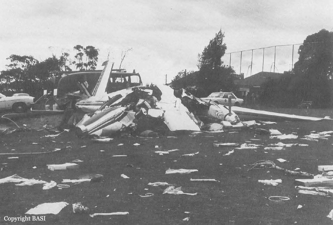
Crash of a Rockwell Shrike Commander 500S in Melbourne: 2 killed

Date & Time: Aug 10, 1979 at 1508 LT
Operator:
Registration:
VH-ALH
Flight Type:
Survivors:
No
Schedule:
Whitemark - Melbourne
MSN:
500-1810-20
YOM:
1968
Country:
Region:
Crew on board:
1
Crew fatalities:
Pax on board:
1
Pax fatalities:
Other fatalities:
Total fatalities:
2
Captain / Total flying hours:
8500
Captain / Total hours on type:
100.00
Circumstances:
During the morning of August 9, 1979, the aircraft was refuelled to capacity and three drums, each with a capacity of 20 litres, were also filled with fuel and placed in the baggage compartment. The aircraft, loaded with freight, subsequently departed Essendon at 1335 hours and proceeded to Cambridge where it arrived at 1536 hours. The freight was unloaded and, at 1621 hours, the aircraft departed for Launceston where it arrived at 1653 hours. It was again loaded with freight and departed Launceston at 1720 hours bound for Flinders Island. The aircraft landed at Flinders Island several minutes after the end of daylight, which was at 1745 hours, and the freight was unloaded. On the following day, the aircraft was again loaded with freight and the pilot subsequently reported departure from Flinders Island at 1329 hours, bound for Essendon. The take-off run was observed to be longer than usual for this type of aircraft and its rate of climb appeared to be less than normal. The IFR flight plan notified by the pilot before departure indicated his intention to cruise at an altitude of 4500 feet but, at 1410 hours, he reported to Melbourne Flight Service Unit "request traffic for a descent to proceed VFE we're getting 50 knot head wind here". On being advised that there was no traffic information, the pilot reported leaving 4500 feet. At 1502 hours, the pilot established communication with Essendon Tower, reported approaching Channel 0 at 1500 feet, and "request expedite clearance". He was issued with a clearance to enter controlled airspace at 1500 feet tracking from Channel 0 to Essendon via Clifton Hill. At 1506 hours he reported at Clifton Hill and, at 1507:38 hours, he advised "I'm sorry have a Mayday appear to have a fuel problem we'll have to land on a golf course". On being asked "which golf course?, the pilot replied "oh right where we are now". No further communications were received from the aircraft. The aircraft was observed by witnesses in the Northcote area initially on a north-westerly heading towards Essendon. E was seen to be descending and the sound of the engines was not normal. After flying over the northern section of the Northcote Municipal Golf Course, the aircraft commenced a descending left turn and [passed over a power transmission line which ran in a north-south direction near the western boundary of the golf course. As the turn continued towards an easterly heading, the aircraft again passed over the power line, at a very low height, and in strong tail wind conditions struck trees bordering a fairway while in a slightly left wing down, nose down, attitude. It struck the ground heavily just beyond the trees and the main wreckage travelled a further 73 metres before it came to rest on the edge of a green in the south-eastern corner of the golf course. Detailed examination of the wreckage of the aircraft revealed no evidence of any defect or malfunction which may have contributed to the accident. There was no significant fuel in the fuel systems of the two engines and there was negligible fuel in those cells of the fuel storage system which were undamaged. There was no fire. The pilot was in full time employment as an airline captain with a major operator. He was also involved financially and managerially in Norfish Pty. Ltd. and both he and the Company had financial difficulties at that time. The flight plan submitted by the pilot before departure from Essendon on August 9 contained false names in respect of both the pilot and the operator. Neither the pilot nor Norfish Pty Ltd held a Charter or Aerial Work Licence. The maximum specified take-off weight for the aircraft was 3357 kg. for VFR operations and 3243 kg. for IFR operations. It has been calculated that the gross weight of the aircraft was 3775 kg. when it departed Essendon for Cambridge on 9.8.79 and 3746 kg. when it departed Launceston for Flinders Island on the same day. The calculated gross weight was 4061 kg. when it departed Flinders Island on the day of the accident. Although fuel was available at Cambridge and Launceston, the aircraft was not refuelled after it 'departed from Essendon. The three 20 litre drums were located in the aircraft wreckage and, although all were damaged, detailed examination indicated that they ruptured under the action of hydraulic shock and that they wert filled at the time of the accident. The total operating time of the aircraft from departure Essendon until the time of the accident was consistent with a fuel endurance which could be expected in the circumstances leading to this accident.
Probable cause:
The cause of the accident was that the aircraft was operated with insufficient fuel to safely complete the flight.
Final Report:

Crash of a Partenavia P.68B off the Wilsons Promontory National Park: 2 killed

Date & Time: Jul 2, 1978 at 1622 LT
Type of aircraft:
Operator:
Registration:
VH-FAX
Flight Phase:
Flight Type:
Survivors:
No
Schedule:
Flinders Island - Melbourne
MSN:
46
YOM:
1975
Country:
Region:
Crew on board:
1
Crew fatalities:
Pax on board:
1
Pax fatalities:
Other fatalities:
Total fatalities:
2
Captain / Total flying hours:
420
Captain / Total hours on type:
200.00
Circumstances:
On the morning of 2.7.78 the pilot obtained the relevant meteorological forecasts and submitted a flight plan to the Moorabbin Briefing Office for a flight from Moorabbin to Flinders Island and return. He did not hold an instrument rating and was therefore restricted to flight in accordance with the Visual Flight Rules (VFR). The forecasts indicated patches of fog over the route initially, with areas of rain developing later in the day. Broken layers of stratus and strato-cumulus cloud were forecast but there was nothing to suggest that VFR flight would not be possible. The VFR flight plan submitted indicated an estimated flight time of 89 minutes to Flinders Island and 72 minutes for the return flight. The fuel endurance was stated as 300 minutes. After being refuelled to capacity, the aircraft departed from Moorabbin at 1007 hours and the pilot subsequently reported in the Flinders Island circuit area at 1143 hours. The aircraft landed at Flinders Island Aerodrome and the pilot and passenger proceeded by motor vehicle to a farming property some 40 kilometres distant. On returning to the aerodrome later in the day the pilot attempted to obtain up-to-date weather information for the return flight but the telephone was found to be unserviceable. By this time, the earlier forecasts covering the route had been amended and generally indicated some deterioration in conditions, particularly in relation to increased cloud at the lower levels. Nevertheless, the forecast conditions suggested that VFR flight could be possible over the route. The amended terminal forecast for Moorabbin also indicated increasing low cloud. The pilot and the passenger were seen to board the aircraft which then took off and circled the aerodrome before being obscured by cloud. At this time the weather to the south of Flinders Island Aerodrome was squally and the nearby mountain was partly covered by cloud. At 1543 hours the pilot established radio communication with Launceston Flight Service Unit (FSU) and reported his departure from Flinders Island at 1541 hours, his intention to cruise below 5000 feet and his estimated time over South East Point (southern end of Wilson's Promontory) as 1617 hours. He also asked for confirmation that Moorabbin Airport was open to VFR traffic. He was advised that Moorabbin was "not closed to VFR at the moment however they expect it to be". He was also given the current terminal forecast for Moorabbin and the sections of the relevant area forecasts relating to cloud. He was requested to call Melbourne FSU at 1550 hours. At 1551 hours the pilot established communication with Melbourne FSU and, at 1600 hours, he again asked for confirmation that Moorabbin Airport was open to VFR operations and was advised in the affirmative. He then reported that he was climbing to his planned altitude of 6500 feet and, at 1607 hours, reported that he was climbing to 8500 feet. At 1620 hours he reported an amended estimated time over South East Point as 1625 hours and again requested confirmation that Moorabbin was still open to VFR operations. He was again advised in the affirmative. At 1622 hours the pilot broadcast the call sign of the aircraft once very rapidly and the pitch of his voice was raised above normal. The flight service officer heard but did not understand the call and twice requested the calling aircraft to repeat its call. There was no reply and no further communications were received from the aircraft. Following failure of the aircraft to report position at South East Point, the Uncertainty Phase of search and rescue procedures was declared at 1640 hours. When widespread checks failed to establish the location of the aircraft, the Alert Phase was declared at 1713 hours and this was upgraded to the Distress Phase at 1745 hours. A search of the probability area was carried out by air, land and sea during the next three days and, on the morning of 3. 7. 78, two seats and a left main wheel assembly from a Partenavia P68B aircraft were found on the eastern shoreline of Wilson's Promontory. Additionally, three life jackets with the name "TIPPETT" stencilled on them were found in the same area. No trace of the main wreckage of the aircraft, or of the occupants, has been found. Damage to the recovered aircraft seats and wheel assembly was consistent with them having been attached to an aircraft which had struck the water at high speed in a nose down, left wing down attitude. Post analysis of the meteorological situation at the time of the accident indicated that a complex low pressure system was moving across Victoria. There was extensive cloud cover in the Wilson's Promontory area and the base of the lowest cloud was 1000/2000 feet. Visibility was reduced in areas of heavy rain showers. The interaction of differing air masses could have produced conditions conducive to severe airframe icing In respect of aircraft operating at altitudes between 5000 and 7000 feet.
Probable cause:
There is insufficient evidence available to enable the cause of this accident to be determined.
Final Report:

Crash of an Avro 652A Anson I in Loch: 2 killed

Date & Time: Feb 10, 1960
Type of aircraft:
Registration:
VH-FIB
Flight Phase:
Flight Type:
Survivors:
No
Site:
Schedule:
Whitemark – Melbourne
Location:
Country:
Region:
Crew on board:
2
Crew fatalities:
Pax on board:
0
Pax fatalities:
Other fatalities:
Total fatalities:
2
Circumstances:
The crew was performing a cargo flight from Whitemark (Flinders Island) to Melbourne-Moorabbin with a load of crayfish. While overflying Bass Strait, an engine failed. The crew jettisoned the cargo but was unable to maintain a safe altitude. While approaching Loch, the airplane stalled and crashed in flames onto a hill. The aircraft was destroyed and both pilots were killed.
Probable cause:
Engine failure.

Crash of a Lockheed L-414 Hudson I off Flinders Island: 4 killed

Date & Time: Oct 11, 1942
Type of aircraft:
Operator:
Registration:
A16-18
Flight Phase:
Flight Type:
Survivors:
No
Schedule:
Bairnsdale – Whitemark
MSN:
414-1869
YOM:
1940
Country:
Region:
Crew on board:
4
Crew fatalities:
Pax on board:
0
Pax fatalities:
Other fatalities:
Total fatalities:
4
Circumstances:
While on a flight from Bairnsdale to Whitemark (Flinders Island), the twin engine aircraft crashed into the sea in unknown circumstances. SAR mission was conducted but evetually suspended after few days as no trace of the aircraft nor the crew was found. 18 RAAF aircraft took part of the SAR operation.
Crew (1st OTU):
P/O Edward R. Deacon,
Sgt Albert F. Manning,
Sgt Cecil H. Andrews,
Sgt William Anderson.

Crash of an Avro 652 Anson I in Whitemark

Date & Time: Dec 20, 1939
Type of aircraft:
Operator:
Registration:
A4-17
Flight Phase:
Flight Type:
Survivors:
Yes
Country:
Region:
Crew on board:
4
Crew fatalities:
Pax on board:
0
Pax fatalities:
Other fatalities:
Total fatalities:
0
Circumstances:
En route, the pilot encountered an unexpected situation and was forced to make an emergency landing near the Whitemark Airfield. While all four occupants were uninjured, the aircraft was damaged beyond repair.

Crash of a De Havilland DH.86 off Whitemark: 5 killed

Date & Time: Oct 2, 1935 at 0955 LT
Type of aircraft:
Operator:
Registration:
VH-URT
Survivors:
No
Schedule:
Sydney – Melbourne – Whitemark – Launceston – Hobart
MSN:
2312
YOM:
1935
Country:
Region:
Crew on board:
3
Crew fatalities:
Pax on board:
2
Pax fatalities:
Other fatalities:
Total fatalities:
5
Circumstances:
The airplane was approaching Whitemark Airport (Flinders Island) when it crashed in unknown circumstances into the sea, some 3 km offshore. The aircraft named Loina was destroyed and all five occupants were killed.
Crew:
Norman Evans, pilot,
Maxwell Brown, copilot,
Edward Best, flight engineer.
Passengers:
G. S. Anderson,
G. Garlick.
Probable cause:
It was determined that VH-URT had gone into an uncontrollable spin, and three possible precipitating factors were: a loss of control after a power plant failure, the fouling of the tail surfaces while the trailing aerial was being reeled in or a structural failure. There was also evidence of a small fire in the rear of its cabin, which may have occurred before the crash, but this probably did not factor in the accident. And in view of two fatal accidents and other difficulties with the type, Australia would subsequently suspend the certificate of airworthiness of the De Havilland 86.