Zone

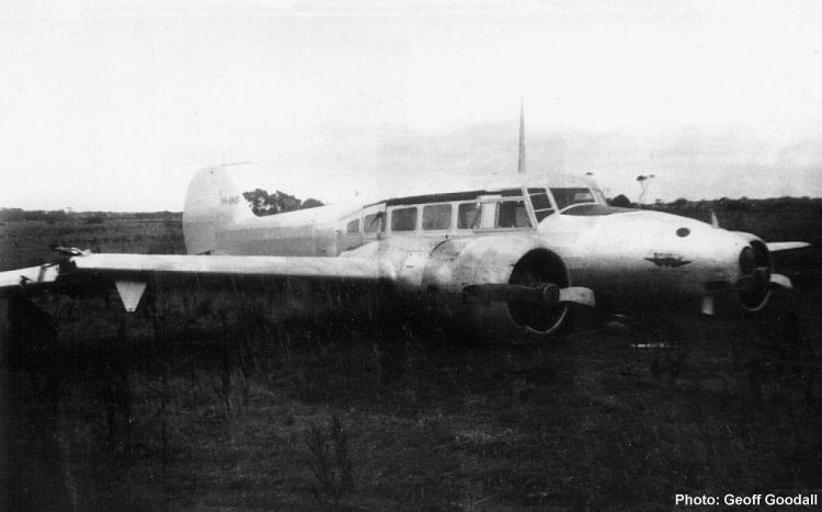
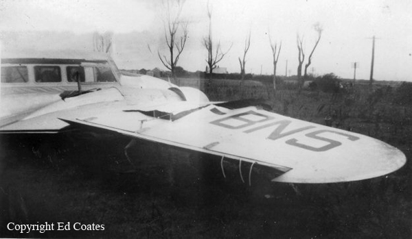
Crash of a Piper PA-31-350 Navajo Chieftain in Launceston: 6 killed

Date & Time: Sep 17, 1993 at 1943 LT
Operator:
Registration:
VH-WGI
Survivors:
Yes
Schedule:
Melbourne - Launceston
MSN:
31-7305075
YOM:
1973
Country:
Region:
Crew on board:
1
Crew fatalities:
Pax on board:
9
Pax fatalities:
Other fatalities:
Total fatalities:
6
Captain / Total flying hours:
701
Captain / Total hours on type:
3.00
Aircraft flight hours:
8712
Circumstances:
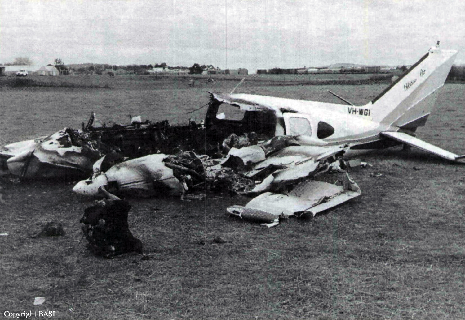
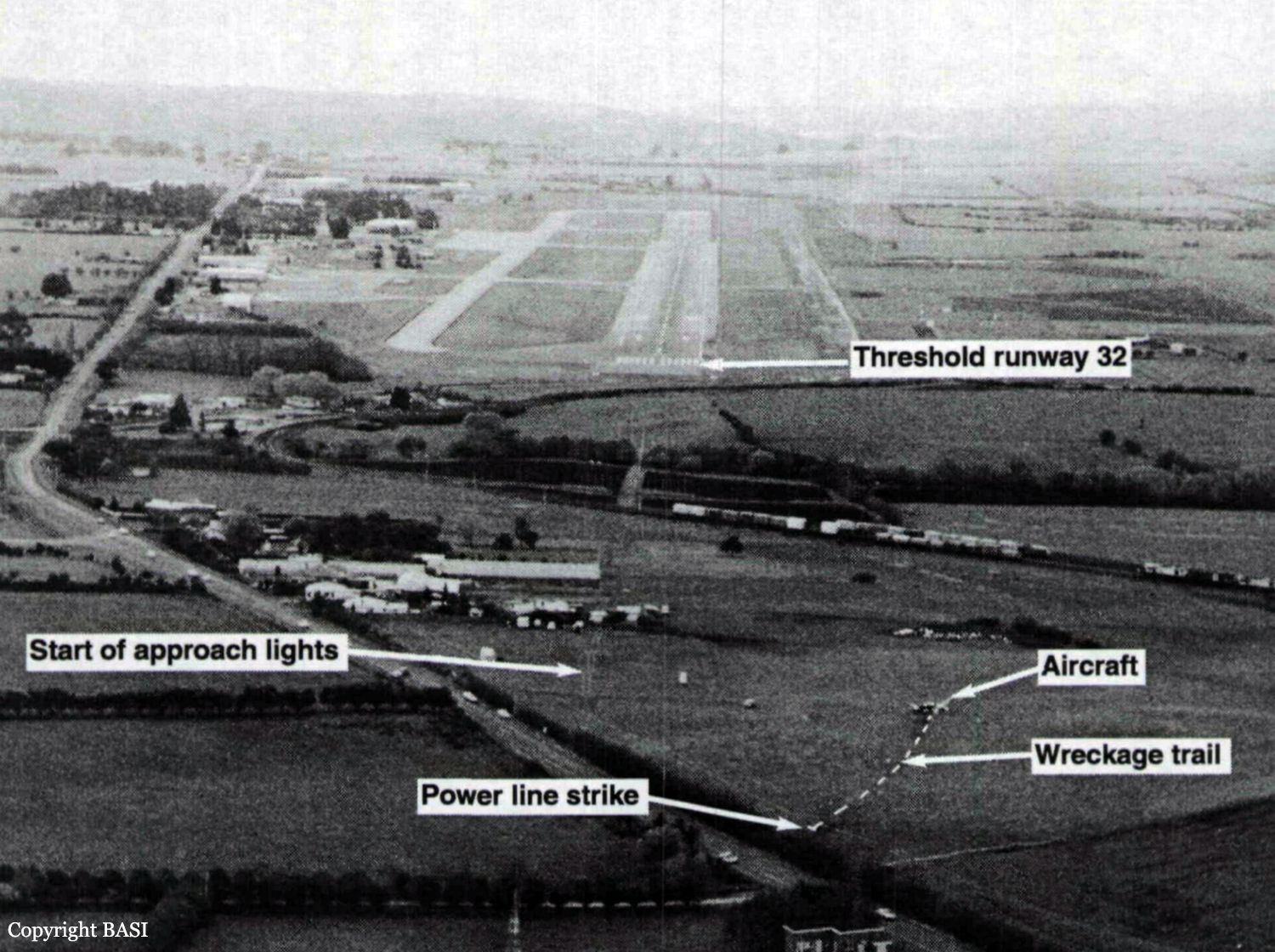
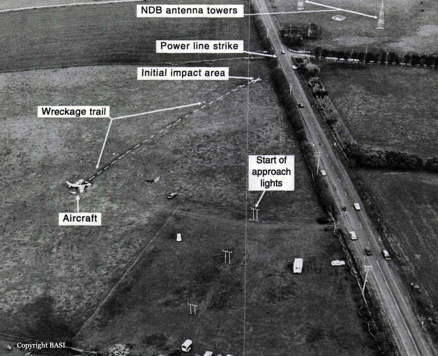
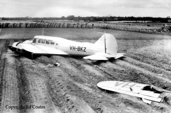
Members of a football club had planned to visit Launceston, travelling by light aircraft. Three aircraft were needed to carry the group, with all passengers and pilots contributing to the cost of the aircraft hire. One of the club members, who was a pilot, organised the required aircraft and additional pilots for departure from Moorabbin Airport on the afternoon of 17 September 1993. The operator from whom the aircraft were hired, who also employed the organising pilot as an instructor, arranged for one Piper PA-23 (VH-PAC), a Piper PA-31-310 (VH-NOS) and a Piper PA-31-350 (VH-WGI) to be available for the trip, with the organising pilot to fly VH-WGI. On the day of the flight the pilot of VH-WGI carried out pre-flight inspections, obtained the weather forecasts and submitted flight plans for all three aircraft. The flight plans for the two PA-31 aircraft were for flights operated in accordance with IFR procedures. The PA-23 was to operate in accordance with VFR procedures. The TAF for Launceston predicted 2 octas of stratocumulus cloud, base 2,000 ft and 3 octas of stratocumulus cloud, base 3,500 ft. The flight plan for VH-WGI (see fig. 2) indicated that the aircraft would track Moorabbin Wonthaggi-Bass-Launceston and cruise at an altitude of 9,000 ft. A cruise TAS of 160 kts, total plan flight time of 90 minutes, endurance 155 minutes and Type of Operation 'G' (private category flight) were specified. No alternate aerodrome was nominated and none was required. The estimated time of departure was 1730. The flight plan was submitted to the CAA by facsimile at 1529. Last light at Launceston was 1919. VH-WGI departed Moorabbin at 1817 and climbed to an en-route cruise altitude of 9,000 ft. The pilot was required to report at Wonthaggi but passed this position at 1832 without reporting. Melbourne ATC tried unsuccessfully to contact the pilot because of this missed report. Later, the Melbourne radar controller noticed the aircraft deviating left of track but was unable to make contact. Communications were re-established at 1858 when the pilot called Melbourne FS saying he had experienced a radio problem. By this time the aircraft heading had been corrected to regain track. At 1927 the pilot called Launceston Tower and was cleared for a DME arrival along the inbound track of the Launceston VOR 325 radial. The Launceston ATIS indicated 2 octas of cloud at 800 ft, QNH 1,012 hPa, wind 320° at 5-10 kts, temperature +10° and runway 32 in use. At 1930 the ADC advised the pilot that the 2 octas of cloud were clear of the inbound track, but that there was some lower cloud forming just north of the field, possibly on track. He informed the pilot that there was a chance he might not be visual by the VOR, in which case he would need to perform an ILS approach via the Nile locator beacon. The ADC contacted the airport meteorological observer at 1933, inquiring as to what the 1930 searchlight check of cloud height had revealed. He was told the observation indicated 7 octas of cloud at about 800 ft. At 1935.52 (time in hours, minutes and seconds) the ADC asked the pilot for his DME (distance) and level. The pilot responded that he was at 12 DME and 3,300 ft. The ADC told the pilot that conditions were deteriorating with probably 4 octas at 800 ft at the field. He then told the pilot he would hopefully get a break in the cloud, but then restated that if he was not visual by the VOR to make a missed approach, track to Nile and climb to 3,000 ft. At 1939.45 the pilot was again asked for his DME and level. He indicated that he was at 1,450 ft and 2-3 DME. He then also confirmed that he was still in IMC. There were three other aircraft inbound for Launceston and the ADC made an all-stations broadcast that conditions were deteriorating at Launceston, with 4 octas at 800 ft, and to expect an ILS approach. At 1940.56 the pilot stated that he was overhead the field, but did not have it sighted and was going around. At 1941.07 the pilot reported that he had the airfield in sight and at 1941.16 that he was positioned above the final approach for runway 32. Fifteen seconds later the pilot reported that he was opposite the tower and was advised by the ADC that he was cleared for a visual approach, or a missed approach to Nile as preferred. The pilot indicated he would take the visual approach and was then told to manoeuvre as preferred for runway 32. This was acknowledged at 1941.48. No further communications were received from the pilot. The ADC made a broadcast to two other inbound aircraft at 1942.32, advising that VH-WGI was in the circuit ahead of them, that it had become visual about half a mile south of the VOR, that it was manoeuvring for a visual approach and was just in and out of the base of the cloud. After the pilot of VH-WGI reported over the field, and the aircraft first appeared out of cloud, witnesses observed it track to about the south-east end of the aerodrome at a height of about 500-800 ft. It then turned left to track north-west on the north-east side of the main runway and approximately over the grass runway. The aircraft was seen to be travelling at high speed, and passing through small areas of cloud. North of the main terminal building a left turn was initiated onto a close downwind leg for runway 32. The aircraft appeared to descend while on this leg. As the base turn was started, at a height estimated as 300-500 ft, the aircraft briefly went through cloud. Some of the witnesses reported that the engine noise from the aircraft during the approach was fairly loud, suggestive of a high power setting. Late on a left base leg the aircraft was observed to be in a steep left bank, probably in the order of 60°, at a height of about 200 ft. It then descended rapidly and struck a powerline with the right wing, approximately 28 ft AGL, resulting in an airport electrical power failure at 1943.02. Almost simultaneously the left wing struck bushes. A short distance beyond the powerlines the aircraft struck the ground and slid to a stop. A fierce fire broke out immediately. Airport fire services responded to the accident and the fire was quickly extinguished. Six of the occupants received fatal injuries and the others, including the pilot, were seriously injured.
Probable cause:
The following findings were reported:
1. The actual weather at Launceston at the time of arrival of VH-WGI was significantly worse than forecast.
2. The pilot did not have the required recent experience to conduct either an IFR flight or an ILS approach. The operator's procedures did not detect this deficiency.
3. The pilot's inexperience and limited endorsement training did not adequately prepare him for IFR flight in the conditions encountered.
4. The CAA did not specify adequate endorsement training or minimum endorsement time requirements for aircraft of the class of the PA-31-350, particularly in regard to the endorsement of inexperienced pilots.
5. An absence of significant decision-making training requirements contributed to the poor decision-making action by the pilot who decided to continue with a visual circling approach at Launceston in conditions that were unsuitable for such an approach.
6. As a consequence of continuing the approach, the pilot subjected himself to an overwhelming workload. This was due to a combination of adverse weather conditions, his lack of training and experience in IFR approach procedures on the type, and a misinterpretation of (or non-compliance with) the AIP/DAP-IAL instructions, a combination which appears to have influenced the pilot to fly a close-in, descending circuit at low altitude. The carriage of alcohol-affected passengers may have also added to the level of difficulty.
7. Because of workload, and possibly also due to distractions, the pilot inadvertently allowed the aircraft to enter a rapid descent at a critical stage of the approach, at an altitude from which recovery could not be effected.
Final Report:

Crash of a Rockwell Grand Commander 680E in King Island

Date & Time: Jul 14, 1988 at 2017 LT
Operator:
Registration:
VH-CAY
Flight Type:
Survivors:
Yes
Schedule:
Melbourne – King Island
MSN:
680-0855-76
YOM:
1959
Country:
Region:
Crew on board:
1
Crew fatalities:
Pax on board:
1
Pax fatalities:
Other fatalities:
Total fatalities:
0
Circumstances:
The King Island aerodrome weather was forecast to include temporary periods of moderate to heavy rain showers, six eighths of cloud cover base 800 feet and visibility reduced to 3000 metres. The forecast surface wind was 340 degrees at 20-30 knots. The pilot's qualifications required a minimum visibility of 5000 metres for operation at night in Visual Meteorological Conditions, (NGT VMC). It was planned that another pilot, qualified for Instrument Flight Rules (IFR) operations, would act as pilot in command, but he became unavailable. The flight plan submitted by the pilot indicated he would be operating under the IFR category and when queried on taxiing he confirmed that this was so. Shortly after DEPARTURE, the pilot requested a weather report from an IFR pilot who had just landed at King Island. This gave a cloud base of 2000 feet, heavy rain showers and visibility of 2000 metres. Flares had been laid to allow the other pilot to use Runway 35 because of the strong northerly wind. The pilot of VH-CAY activated the electric lighting for Runway 28. He reported that the weather was satisfactory enroute and he could see lights ahead on the island. On crossing the coast flight conditions became rough in moderate to severe turbulence. The pilot advised he arrived over the aerodrome at 1500 feet above mean sea level and observed the lighted wind sock was horizontal, with the direction fluctuating rapidly between north and west. He turned to the south and broadcast his intention to land on Runway 28. Neither the pilot nor the passenger had any further recall of the events leading to the accident. VH-CAY was heard passing over the aerodrome and the engine sound was very loud, suggesting to the listener that the aircraft was low. It had been raining continuously for more than an hour, sometimes very heavily, and it was still raining at the time. The aircraft was subsequently seen flying at a very low height some six kilometres south of the aerodrome, tracking approximately north. It was raining very heavily in that area and the wind was very strong. Soon afterwards there was a sound of impact and a flash of light. The aircraft had struck the tops of trees 30 feet high, then descended to the ground. After the aircraft came to rest it was destroyed by a fire. Both occupants were seriously injured.
Probable cause:
Examination of the wreckage was severely hampered by the extreme fire damage sustained, but no evidence was found of any defects that might have contributed to the accident. The aircraft had evidently been under control at the time it collided with the trees. A post analysis of the conditions by the Bureau of Meteorology indicated the possible presence of strong up and down drafts, horizontal wind shear, turbulence, and estimated visibility as 2-3000 metres in rain. The evidence suggested that the pilot may have been lower than he believed as the aircraft overflew the
aerodrome. Having passed overhead, there there would have been few external visual references under the existing conditions to alert him that the aircraft was inadvertently being descended into the ground.
Significant Factors:
The following factors were considered relevant to the development of the accident:
1. The pilot attempted to conduct an operation for which he was not qualified.
2. Severe weather conditions in the destination aerodrome area with strong winds, turbulence, heavy rain and poor visibility.
3. The pilot continued flight into adverse weather conditions.
4. The pilot may have misread his altimeter and been lower than intended.
5. The pilot may have unintentionally descended the aircraft into the ground in conditions of poor visibility.
Final Report:

Crash of a Rockwell Aero Commander 685 in the Bass Strait: 2 killed

Date & Time: Jul 17, 1983 at 1505 LT
Operator:
Registration:
VH-WJC
Flight Phase:
Flight Type:
Survivors:
No
Schedule:
Hobart - Melbourne
MSN:
685-12005
YOM:
1972
Country:
Region:
Crew on board:
2
Crew fatalities:
Pax on board:
0
Pax fatalities:
Other fatalities:
Total fatalities:
2
Circumstances:
On 17 July 1983 the pilot of Rockwell (Aero Commander) 685 aircraft VH-WJC submitted a flight plan to the Hobart Briefing Office for a private category flight from Hobart to Moorabbin, tracking via Launceston and Wonthaggi. The plan indicated that the flight would be conducted under the Instrument Flight Rules (IFR) at Flight Level 120 (12 000 feet altitude on standard atmospheric pressure of 1013.2 millibars), with two persons on board. The flight plan showed that the aircraft had a fuel endurance of 220 minutes, and carried an Emergency Locator Beacon (ELB) and life jackets. There was no indication that a life raft was carried. The aircraft departed Hobart at 1352 hours and, thereafter, the pilot made the appropriate radio reports to Hobart Tower, Launceston Control and Launceston Tower. The flight apparently progressed normally until 1452 hours when the pilot advised Launceston Control, "Er Whiskey Juliet Charlie we seem to have been in trouble with er fuel here the red er warning light comes on and the gauge is down . . .".At 1454 hours the pilot transmitted a Mayday call, indicating that he was descending from Flight Level 120 on track to Bass (a position reporting point), present position was 85 nautical miles (nm) from Launceston and he would be making a controlled ditching. Launceston Control immediately initiated the Distress phase of the Search and Rescue procedures and advised the Melbourne Operational Control Centre (OCC). Further communications between the aircraft and Launceston Control indicated that the aircraft was continuing descent on track towards Wonthaggi. The last position report from the pilot, at 1500 hours, was 94 nm from Wonthaggi. The last recorded transmission from the aircraft was at 1501 hours when the pilot confirmed that there were two persons on board. There were no indications at any time from the pilot that the fuel supply had been exhausted or that either engine had failed. It was estimated that the aircraft ditched at about 1505 hours, at an approximate position of 81 nm from Wonthaggi on the planned track. No trace of the aircraft nor both occupants was found.
Probable cause:
Due to lack of evidences, the exact cause of the accident could not be determined.
Final Report:

Crash of a Partenavia P.68B off the Wilsons Promontory National Park: 2 killed

Date & Time: Jul 2, 1978 at 1622 LT
Type of aircraft:
Operator:
Registration:
VH-FAX
Flight Phase:
Flight Type:
Survivors:
No
Schedule:
Flinders Island - Melbourne
MSN:
46
YOM:
1975
Country:
Region:
Crew on board:
1
Crew fatalities:
Pax on board:
1
Pax fatalities:
Other fatalities:
Total fatalities:
2
Captain / Total flying hours:
420
Captain / Total hours on type:
200.00
Circumstances:
On the morning of 2.7.78 the pilot obtained the relevant meteorological forecasts and submitted a flight plan to the Moorabbin Briefing Office for a flight from Moorabbin to Flinders Island and return. He did not hold an instrument rating and was therefore restricted to flight in accordance with the Visual Flight Rules (VFR). The forecasts indicated patches of fog over the route initially, with areas of rain developing later in the day. Broken layers of stratus and strato-cumulus cloud were forecast but there was nothing to suggest that VFR flight would not be possible. The VFR flight plan submitted indicated an estimated flight time of 89 minutes to Flinders Island and 72 minutes for the return flight. The fuel endurance was stated as 300 minutes. After being refuelled to capacity, the aircraft departed from Moorabbin at 1007 hours and the pilot subsequently reported in the Flinders Island circuit area at 1143 hours. The aircraft landed at Flinders Island Aerodrome and the pilot and passenger proceeded by motor vehicle to a farming property some 40 kilometres distant. On returning to the aerodrome later in the day the pilot attempted to obtain up-to-date weather information for the return flight but the telephone was found to be unserviceable. By this time, the earlier forecasts covering the route had been amended and generally indicated some deterioration in conditions, particularly in relation to increased cloud at the lower levels. Nevertheless, the forecast conditions suggested that VFR flight could be possible over the route. The amended terminal forecast for Moorabbin also indicated increasing low cloud. The pilot and the passenger were seen to board the aircraft which then took off and circled the aerodrome before being obscured by cloud. At this time the weather to the south of Flinders Island Aerodrome was squally and the nearby mountain was partly covered by cloud. At 1543 hours the pilot established radio communication with Launceston Flight Service Unit (FSU) and reported his departure from Flinders Island at 1541 hours, his intention to cruise below 5000 feet and his estimated time over South East Point (southern end of Wilson's Promontory) as 1617 hours. He also asked for confirmation that Moorabbin Airport was open to VFR traffic. He was advised that Moorabbin was "not closed to VFR at the moment however they expect it to be". He was also given the current terminal forecast for Moorabbin and the sections of the relevant area forecasts relating to cloud. He was requested to call Melbourne FSU at 1550 hours. At 1551 hours the pilot established communication with Melbourne FSU and, at 1600 hours, he again asked for confirmation that Moorabbin Airport was open to VFR operations and was advised in the affirmative. He then reported that he was climbing to his planned altitude of 6500 feet and, at 1607 hours, reported that he was climbing to 8500 feet. At 1620 hours he reported an amended estimated time over South East Point as 1625 hours and again requested confirmation that Moorabbin was still open to VFR operations. He was again advised in the affirmative. At 1622 hours the pilot broadcast the call sign of the aircraft once very rapidly and the pitch of his voice was raised above normal. The flight service officer heard but did not understand the call and twice requested the calling aircraft to repeat its call. There was no reply and no further communications were received from the aircraft. Following failure of the aircraft to report position at South East Point, the Uncertainty Phase of search and rescue procedures was declared at 1640 hours. When widespread checks failed to establish the location of the aircraft, the Alert Phase was declared at 1713 hours and this was upgraded to the Distress Phase at 1745 hours. A search of the probability area was carried out by air, land and sea during the next three days and, on the morning of 3. 7. 78, two seats and a left main wheel assembly from a Partenavia P68B aircraft were found on the eastern shoreline of Wilson's Promontory. Additionally, three life jackets with the name "TIPPETT" stencilled on them were found in the same area. No trace of the main wreckage of the aircraft, or of the occupants, has been found. Damage to the recovered aircraft seats and wheel assembly was consistent with them having been attached to an aircraft which had struck the water at high speed in a nose down, left wing down attitude. Post analysis of the meteorological situation at the time of the accident indicated that a complex low pressure system was moving across Victoria. There was extensive cloud cover in the Wilson's Promontory area and the base of the lowest cloud was 1000/2000 feet. Visibility was reduced in areas of heavy rain showers. The interaction of differing air masses could have produced conditions conducive to severe airframe icing In respect of aircraft operating at altitudes between 5000 and 7000 feet.
Probable cause:
There is insufficient evidence available to enable the cause of this accident to be determined.
Final Report:

Crash of an Avro 652 Anson I in Melbourne

Date & Time: Apr 12, 1960
Type of aircraft:
Operator:
Registration:
VH-BAB
Flight Type:
Survivors:
Yes
Country:
Region:
Crew on board:
3
Crew fatalities:
Pax on board:
0
Pax fatalities:
Other fatalities:
Total fatalities:
0
Circumstances:
After landing at Melbourne-Moorabbin, the crew attempted to vacate the runway when the left main gear collapsed. The airplane sunk on its belly and came to rest. All three crew members were uninjured while the aircraft was damaged beyond repair.
Probable cause:
Failure of the left main gear after landing.

Crash of an Avro 652A Anson I in Loch: 2 killed

Date & Time: Feb 10, 1960
Type of aircraft:
Registration:
VH-FIB
Flight Phase:
Flight Type:
Survivors:
No
Site:
Schedule:
Whitemark – Melbourne
Location:
Country:
Region:
Crew on board:
2
Crew fatalities:
Pax on board:
0
Pax fatalities:
Other fatalities:
Total fatalities:
2
Circumstances:
The crew was performing a cargo flight from Whitemark (Flinders Island) to Melbourne-Moorabbin with a load of crayfish. While overflying Bass Strait, an engine failed. The crew jettisoned the cargo but was unable to maintain a safe altitude. While approaching Loch, the airplane stalled and crashed in flames onto a hill. The aircraft was destroyed and both pilots were killed.
Probable cause:
Engine failure.

Crash of a De Havilland DH.60 Moth in Melbourne

Date & Time: Nov 22, 1959
Type of aircraft:
Operator:
Registration:
VH-UGM
Flight Type:
Survivors:
Yes
Schedule:
Melbourne - Melbourne
MSN:
453
YOM:
1928
Country:
Region:
Crew on board:
1
Crew fatalities:
Pax on board:
0
Pax fatalities:
Other fatalities:
Total fatalities:
0
Circumstances:
Built in 1928, the aircraft was restored for three years and has just been delivered to its new owner, J. O. Richardson, three days prior to the accident. The pilot, sole on board, was completing a local flight at Moorabbin Airport. On final approach, the engine failed. The aircraft stalled and crashed short of runway. The pilot was injured and the aircraft was destroyed.
Probable cause:
Engine failure on final approach.

Crash of an Avro 652A Anson I in Melbourne

Date & Time: Apr 3, 1953
Type of aircraft:
Operator:
Registration:
VH-BNS
Flight Phase:
Flight Type:
Survivors:
Yes
Schedule:
Melbourne – Sydney
Country:
Region:
Crew on board:
2
Crew fatalities:
Pax on board:
0
Pax fatalities:
Other fatalities:
Total fatalities:
0
Circumstances:
Shortly after takeoff from Melbourne-Moorabbin Airport, while climbing to a height of 20 feet, the right engine failed. The aircraft stalled, hit the ground past the runway end, lost its undercarriage, went through a fence and came to rest in a field. While both crew members were unhurt, the aircraft was damaged beyond repair.
Probable cause:
Failure of the right engine just after liftoff.

Crash of an Avro 652 Anson I in Melbourne

Date & Time: Feb 20, 1953
Type of aircraft:
Operator:
Registration:
VH-BKT
Flight Phase:
Flight Type:
Survivors:
Yes
Country:
Region:
Crew on board:
2
Crew fatalities:
Pax on board:
0
Pax fatalities:
Other fatalities:
Total fatalities:
0
Circumstances:
Crashed on takeoff for unknown reason. Both occupants were uninjured while the aircraft was damaged beyond repair. The airplane was operated by Brain & Brown Airfreighters (BBA Cargo).

Crash of an Avro 652A Anson I in Melbourne

Date & Time: Jan 17, 1953
Type of aircraft:
Operator:
Registration:
VH-BKZ
Flight Phase:
Flight Type:
Survivors:
Yes
Schedule:
Melbourne - Melbourne
Country:
Region:
Crew on board:
3
Crew fatalities:
Pax on board:
0
Pax fatalities:
Other fatalities:
Total fatalities:
0
Circumstances:
Shortly after takeoff, the twin engine aircraft suffered an engine failure resulting in its crossing the Centre Dandenong Road beneath the 20 feet high telephone wires which were strung along each side of the road before striking an earth embankment and two fences, tearing off the port wing. While all three crew members were slightly injured, the aircraft was damaged beyond repair.
Probable cause:
Engine failure at rotation.