Zone

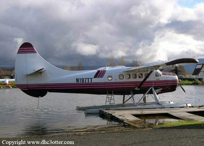
Crash of a De Havilland DHC-3 Otter near McGrath: 1 killed

Date & Time: Aug 27, 2004 at 1600 LT
Type of aircraft:
Operator:
Registration:
N197TT
Flight Phase:
Survivors:
Yes
Site:
Schedule:
Kenai – McGrath – Kotzebue
MSN:
197
YOM:
1957
Location:
Crew on board:
2
Crew fatalities:
Pax on board:
1
Pax fatalities:
Other fatalities:
Total fatalities:
1
Captain / Total flying hours:
10500
Copilot / Total flying hours:
210
Circumstances:
The airline transport certificated pilot was conducting a VFR cross-country business flight, transporting cargo and personnel to a remote airport. The accident airplane was one of two airplanes transporting supplies for a hunting/fishing company, traveling a multi-segment route. The pilot was accompanied by a pilot-rated passenger occupying the right front seat, and a second passenger seated behind the pilot. The pilot obtained a weather briefing from the FAA, which included AIRMETs for mountain obscuration, and IFR conditions due to low ceilings and visibility in smoke, light rain and mist. The pilot said that when he took off on the accident flight, the visibility was 1 to 3 miles in smoke, haze, and fog, but was VFR. He recalled hazy conditions in which he could see rolling hills and river cuts. The pilot-rated passenger was initially flying the airplane. Upon entering lowering visibility, the pilot said he reassumed control of the airplane, and attempted a 180 degree turn to clear the low visibility area, but collided with trees and crashed. The rear seat passenger reported that the accident airplane was flying about 500 to 1,000 feet above the ground because of smoke and fog. He estimated the visibility at takeoff was about 1 mile. About 30 minutes after departure, the airplane was flying over mountainous terrain, and appeared to be following a canyon. The passenger said that the visibility decreased due to fog. He said that the airplane's throw-over control yoke was initially positioned in front of the right seat, pilot-rated passenger, when suddenly a mountain ridge appeared in front of the airplane. The pilot repositioned the control yoke in front of the left seat, banked the airplane to the left, and added engine power. Within a few seconds, the passenger indicated that he felt the airplane collide with several trees and then descend to the ground. The airplane came to rest upright with extensive fuselage damage, about 1,400 feet msl. One wing was torn off the airframe. A postcrash fire consumed the wreckage. A terminal forecast for the airport of departure included few clouds at 500 feet, and visibilities as low as 3 miles in smoke and mist. The destination airport for the accident flight segment had few clouds at 100 feet, and visibilities as low as 2 1/2 miles.
Probable cause:
The pilot's inadequate in-flight planning/decision making, his continued VFR flight into instrument meteorological conditions, and his failure to maintain obstacle clearance. Factors contributing to the accident were low ceilings due to smoke, rain, and mist.
Final Report:

Crash of a Cessna 208B Grand Caravan in Kotzebue

Date & Time: Mar 2, 2003 at 1504 LT
Type of aircraft:
Operator:
Registration:
N205BA
Flight Type:
Survivors:
Yes
Schedule:
Shungnak - Kotzebue
MSN:
208B-0890
YOM:
2001
Crew on board:
1
Crew fatalities:
Pax on board:
0
Pax fatalities:
Other fatalities:
Total fatalities:
0
Captain / Total flying hours:
25600
Captain / Total hours on type:
4200.00
Aircraft flight hours:
2082
Circumstances:
Prior to departing on an air taxi flight, the airline transport certificated pilot obtained a weather briefing and filed a VFR flight plan for a trip from his home base, to several remote villages, and return. The area forecast contained an AIRMET for IFR conditions and mountain obscuration due to clouds and light snow. The terminal forecast contained expected conditions that included visibilities ranging from 3 to 3/4 mile in blowing snow, a vertical visibility of 500 feet, and wind speeds from 14 to 22 knots. During the filling of the flight plan, an FAA flight service station specialist advised that VFR flight was not recommended. The pilot acknowledged the weather information and departed. When the pilot took off on the return flight from an airport 128 miles east of his home base, the pilot reported that the visibility at his base was greater than 6 miles. As he neared his home base, the visibility had decreased and other pilots in the area were requesting special VFR clearances into the Class E surface area. The pilot requested a special VFR clearance at 1441, but had to hold outside the surface area for other VFR and IFR traffic. At 1453, a METAR at the airport included a wind 080 of 26 knots, and a visibility of 1 mile in blowing snow. While holding about 7 miles north of the airport, the pilot provided a pilot report that included deteriorating weather conditions east of the airport. Once the pilot was cleared to enter the surface area at 1458, he was provided with an airport advisory that included wind conditions of 25 knots, gusting to 33 knots. While the pilot was maneuvering for the approach, a special aviation weather observation at 1501 included a wind condition of 26 knots, and a visibility of 3/4 mile in blowing snow. The pilot said he established a GPS waypoint 4 miles from the runway and descended to 1,000 feet. He continued inbound and descended to 300 feet. At 1 mile from the airport, the pilot said he looked up from the instrument panel but could not see the airport. He also stated that he was in a whiteout condition. The airplane collided with the snow-covered sea ice, about 1 mile from the approach end of the runway threshold at 1504.
Probable cause:
The pilot's continued VFR flight into instrument meteorological conditions, and his failure to maintain altitude/clearance above the ground, resulting in a collision with snow and ice covered terrain during the final approach phase of a VFR landing. Factors in the accident were whiteout conditions and snow-covered terrain.
Final Report:

Crash of a Piper PA-31T3-T1040 Cheyenne in Kotzebue

Date & Time: Feb 21, 2000 at 1123 LT
Type of aircraft:
Operator:
Registration:
N219CS
Survivors:
Yes
Schedule:
Point Lay - Kotzebue
MSN:
31-8275005
YOM:
1982
Crew on board:
1
Crew fatalities:
Pax on board:
0
Pax fatalities:
Other fatalities:
Total fatalities:
0
Captain / Total flying hours:
13500
Captain / Total hours on type:
4900.00
Aircraft flight hours:
11098
Circumstances:
The airplane collided with frozen pack ice, three miles from the airport, during a GPS instrument approach. Instrument conditions of 3/4 mile visibility in snow and fog were reported at the time of the accident. The pilot stated that he began a steep descent with the autopilot engaged. He indicated that as the airplane crossed the final approach course, the autopilot turned the airplane inbound toward the airport. He continued the steep descent, noted the airplane had overshot the course, and the autopilot was not correcting very well. He disengaged the autopilot and manually increased the correction heading to intercept the final approach course. During the descent he completed the landing checklist, extended the landing gear and flaps, and was tuning both the communications and navigation radios. The pilot said he looked up from tuning the radios to see the sea ice coming up too quickly to react, and impacted terrain. The pilot relayed there were no pre accident anomalies with the airplane, and that he 'did not stay ahead of the airplane.'
Probable cause:
The pilot descended below the minimum descent altitude. Factors associated with this accident were the task overload of the pilot during the instrument approach, and not performing a level off.
Final Report:

Crash of a Cessna 207A Stationair 8 II near Kotzebue: 1 killed

Date & Time: Apr 14, 1999 at 0930 LT
Registration:
N73188
Flight Phase:
Flight Type:
Survivors:
No
Schedule:
Noorvik - Kotzebue
MSN:
207-0568
YOM:
1981
Crew on board:
1
Crew fatalities:
Pax on board:
0
Pax fatalities:
Other fatalities:
Total fatalities:
1
Captain / Total flying hours:
10000
Captain / Total hours on type:
7800.00
Aircraft flight hours:
16790
Circumstances:
The certificated airline transport pilot departed on a flight to a remote village about 37 miles away. The trip was the first since an annual inspection had been completed the day before. The pilot departed with fuel only in the left wing tank. The right wing tank was empty. About 35 minutes later, the pilot was on a return flight to his original departure airport that was within Class E airspace. During the pilot's absence, the airport visibility had decreased to 1 1/2 mile. Instrument meteorological conditions, and special VFR procedures were in use. A 'MAYDAY' was heard over the common traffic advisory frequency, and was monitored by the local flight service station. The voice of the pilot was recognized as the accident pilot. Search personnel found the airplane on a flat area of a frozen, snow-covered lagoon. The weather at the accident site was described as fog, with flat lighting conditions. The wreckage path was oriented away from higher terrain around the destination airport which is located on a peninsula. The airplane had crashed in a nose down attitude, and came to rest inverted. The engine separated completely from the airframe. An examination of the engine revealed fuel throughout, and mechanical continuity. The vacuum pump's internal support post, on which the internal block rotated, was found fractured through 70 percent of its diameter from fatigue, the remaining portion of fracture was overstress. The airplane was equipped with a standby vacuum system. An examination of the airframe located a combination screwdriver in the left wing. The handle was shattered. No flight control cable impingement was observed.
Probable cause:
The pilot's continued VFR flight into instrument meteorological conditions, spatial disorientation, and an inadvertent stall. Factors in the accident were weather conditions consisting of snow and mist, and flat lighting conditions.
Final Report:

Crash of a Piper PA-31-350 Navajo Chieftain in Point Lay

Date & Time: Dec 3, 1998 at 1038 LT
Operator:
Registration:
N3542H
Flight Type:
Survivors:
Yes
Schedule:
Kotzebue - Point Lay
MSN:
31-7952233
YOM:
1979
Crew on board:
1
Crew fatalities:
Pax on board:
0
Pax fatalities:
Other fatalities:
Total fatalities:
0
Captain / Total flying hours:
3069
Captain / Total hours on type:
311.00
Aircraft flight hours:
15638
Circumstances:
A witness observed the airplane circle to land at the completion of an NDB approach. The nighttime meteorological conditions were an 800 feet ceiling, 1 mile visibility in blowing snow, and 26 knot winds. The surrounding terrain was essentially flat, snow covered, and featureless. The witness saw the airplane on final approach misaligned for the runway, and then disappear below an 18 feet msl bluff. He transmitted on the radio to 'get out of there,' and heard no response. About 10 minutes later the accident pilot walked up to the witness' airplane. The pilot told the investigator-in-charge that he was 'beat around by the winds, ...it was snowing pretty hard, I always had the lights, and I was concentrating on the runway. The next thing I knew I was on the ground short of the runway.' The pilot's previous experience to this airport was during daytime, and during visual conditions. The airport, which was being transferred from the Air Force to the North Slope Borough, has medium intensity runway lights (MIRL), and runway end identifier lights (REILS). It does not have visual approach slope indicator (VASI) lights.
Probable cause:
Failure of the pilot to maintain a proper glidepath. Factors associated with this accident were the airport not having a VASI system installed, and the lack of visual perception for the pilot.
Final Report:

Crash of a Cessna 207 Skywagon on Mt Noak: 1 killed

Date & Time: Sep 17, 1998 at 1430 LT
Registration:
N1809Q
Flight Phase:
Flight Type:
Survivors:
No
Site:
Schedule:
Kotzebue - Point Hope
MSN:
207-0787
YOM:
1984
Location:
Crew on board:
1
Crew fatalities:
Pax on board:
0
Pax fatalities:
Other fatalities:
Total fatalities:
1
Captain / Total flying hours:
8891
Captain / Total hours on type:
446.00
Aircraft flight hours:
12268
Circumstances:
The airline transport pilot departed on a CFR Part 135 cargo/mail flight for a remote coastal village. When the flight did not reach the destination, an aerial search was initiated. The wreckage was located the following day in mountainous terrain, 21 miles from the departure airport. The airplane had collided with rising terrain. An AIRMET for mountain obscuration in clouds and precipitation was issued for the pilot's planned route of flight. A pilot that departed about 20 minutes after the accident airplane's departure, had a similar route of flight. He characterized the weather conditions along the accident airplane's route as 'very low visibility with rain, fog and varied layers of cloud cover.' This pilot stated that he changed his route in order to avoid the worsening weather conditions. He added that with satisfactory weather conditions, and given the intended destination of the accident airplane, the standard route of flight would be directly over the mountain that the accident airplane collided with.
Probable cause:
The pilot's continued VFR flight into instrument meteorological conditions. Factors associated with the accident were low ceilings, mountainous/hilly terrain features, rain, and fog.
Final Report:

Crash of a Cessna 207 Skywagon in Kotzebue

Date & Time: Apr 17, 1996 at 1253 LT
Operator:
Registration:
N6282H
Flight Phase:
Flight Type:
Survivors:
Yes
Schedule:
Kotzebue - Selawik
MSN:
207-0465
YOM:
1978
Crew on board:
1
Crew fatalities:
Pax on board:
0
Pax fatalities:
Other fatalities:
Total fatalities:
0
Captain / Total flying hours:
1815
Captain / Total hours on type:
175.00
Aircraft flight hours:
15367
Circumstances:
The pilot was departing a remote airport to begin a VFR cargo flight. The departure path took the airplane over ice covered terrain. The airport was considered to be below basic VFR conditions with light snow and fog, and the visual conditions in the area were considered to be 'flat' with the visibility from 2 to 3 miles. The pilot received a special VFR clearance out of the control zone by a flight service station specialist. After departure, witnesses observed the airplane climb to an estimated 500 feet above the ground and turn to the right. Shortly thereafter, the airplane banked to the right about 90 degrees, then descended to the ground in a wing and nose low attitude. A postaccident inspection of the airframe and engine did not reveal any mechanical malfunction.
Probable cause:
Failure of the pilot to maintain sufficient altitude/clearance above terrain, after becoming spatially disoriented, while maneuvering after takeoff. Factors relating to the accident were: fog, snow, partial obscuration, 'flat' conditions of light, and the lack of a distinct horizon over ice/snow covered terrain.
Final Report:

Crash of a Cessna 207A Skywagon near Kotzebue: 1 killed

Date & Time: Feb 25, 1995 at 1250 LT
Operator:
Registration:
N6479H
Flight Phase:
Survivors:
No
Site:
Schedule:
Kotzebue - Kivalina
MSN:
207-0539
YOM:
1979
Flight number:
UYA1907
Crew on board:
1
Crew fatalities:
Pax on board:
0
Pax fatalities:
Other fatalities:
Total fatalities:
1
Captain / Total flying hours:
1607
Captain / Total hours on type:
333.00
Aircraft flight hours:
8434
Circumstances:
Approximately 10 minutes after departure, the pilot was contacted by a company pilot flying in the opposite direction. During their conversation the pilot stated that he was 'looking for wolves.' Shortly thereafter, the company pilot told the pilot that his radio transmissions were breaking up. The pilot replied that it was probably because he was 'behind a ridge.' The company pilot temporarily went off frequency; however, when he switched back he was unable to contact the pilot. The aircraft was later located on the southwest side of a box canyon about 100 feet below the top of the ridge. The normal course line for the route typically flown by company pilots is 6 miles away. The pilot had no prior experience in mountain flying.
Probable cause:
The pilot's decision to enter a box canyon area at an altitude inadequate to maintain terrain clearance. The pilot's lack of mountain flying experience was a factor in this accident.
Final Report:

Crash of a Beechcraft E18S in Candle

Date & Time: Oct 4, 1980 at 0815 LT
Type of aircraft:
Registration:
N333FL
Flight Phase:
Survivors:
Yes
Schedule:
Candle - Kotzebue
MSN:
BA-29
YOM:
1955
Location:
Crew on board:
1
Crew fatalities:
Pax on board:
4
Pax fatalities:
Other fatalities:
Total fatalities:
0
Captain / Total flying hours:
2660
Captain / Total hours on type:
100.00
Circumstances:
During the takeoff roll from a contaminated runway, the pilot completed the rotation prematurely. Unable to lift off, the twin engine airplane continued, overran and collided with brushes. All five occupants escaped with minor injuries while the aircraft was damaged beyond repair.
Probable cause:
Collision with object during takeoff due to premature liftoff. The following contributing factors were reported:
- The pilot failed to abort takeoff,
- Airport conditions: ice/slush on runway,
- Unable to lift out of ground effect.
Final Report:

Crash of a Beechcraft E90 King Air off Kotzebue

Date & Time: Aug 25, 1980 at 1204 LT
Type of aircraft:
Operator:
Registration:
N908CM
Survivors:
Yes
Schedule:
Barrow - Kotzebue
MSN:
LW-233
YOM:
1977
Crew on board:
1
Crew fatalities:
Pax on board:
5
Pax fatalities:
Other fatalities:
Total fatalities:
0
Captain / Total flying hours:
9430
Captain / Total hours on type:
553.00
Circumstances:
On final approach to Kotzebue-Ralph Wien Memorial Airport in good weather conditions, the pilot failed to realize his altitude was too low. The twin engine airplane struck the water surface and crashed short of runway threshold. All six occupants were rescued.
Probable cause:
Controlled collision with water during initial approach due to improper IFR operation. The following contributing factors were reported:
- The pilot misjudged altitude and clearance,
- The aircraft came to rest in water,
- The pilot descended below minimum IFR altitude to VFR conditions, 400 feet cig, over water approach,
- Hit water while keeping landing in sight.
Final Report: