Ground accident of a Martin 202 in Newark

Date & Time: Nov 2, 1963
Type of aircraft:
Operator:
Registration:
N177A
Flight Phase:
Survivors:
Yes
MSN:
9147
YOM:
1948
Crew on board:
0
Crew fatalities:
Pax on board:
0
Pax fatalities:
Other fatalities:
Total fatalities:
0
Circumstances:
Suffered a ground accident while taxiing at Newark Airport. There were no injuries but the aircraft was damaged beyond repair.

Crash of a Martin 202 in Williamsport: 25 killed

Date & Time: Dec 1, 1959 at 0947 LT
Type of aircraft:
Operator:
Registration:
N174A
Survivors:
Yes
Schedule:
Philadelphia – Harrisburg – Williamsport – Bradford – Erie – Cleveland
MSN:
9159
YOM:
1947
Flight number:
AL371
Crew on board:
4
Crew fatalities:
Pax on board:
22
Pax fatalities:
Other fatalities:
Total fatalities:
25
Captain / Total flying hours:
9790
Captain / Total hours on type:
1180.00
Copilot / Total flying hours:
1153
Copilot / Total hours on type:
92
Circumstances:
Flight 371 of December 1, 1959, was scheduled between Philadelphia, Pennsylvania, and Cleveland, Ohio, with stops at Harrisburg, Williamsport, Bradford, and Erie The flight originated at Philadelphia after departing Atlantic City at 0718 1 as Ferry Flight 174 to Philadelphia. Prior to the departure of Flight 371 Captain Goldsmith received the available en route and terminal weather reports and forecasts. The flight was dispatched IFR but the captain elected to depart VFR because of the existing VFR weather en route. Allegheny company policy is to dispatch all flights IFR unless load conditions or navigation facilities require a VFR release. Flight 371 departed Philadelphia at 0815 with 17 revenue passengers At the time of takeoff the gross weight of the aircraft, was 36,477 pounds, which was 2,083 pounds below the allowable gross takeoff weight at Philadelphia for landing at Harrisburg. Following the takeoff from Philadelphia the flight proceeded VFR to Harrisburg where it landed at 0851 without incident and deplaned four passengers and 404 pounds of cargo. Flight 371 departed Harrisburg at 0906 with 22 revenue passengers, one additional crew member, and 598 pounds of baggage, mail, and cargo The gross weight at time of takeoff was 36,429 pounds, which was 2,081 pounds below the allowable takeoff weight at Harrisburg for landing at Williamsport. The Williamsport weather at 0855 was reported as Partial obscuration, 1,000 feet scattered, estimated 2,500 overcast, visibility 2 miles, light snow; temperature 32, dewpoint 30, wind west-northwest at seven knots; altimeter 30.26 Remarks - 4/10 sky obscured by snow few fracto-stratus at 1,000 feet along mountains. This weather was not available to the pilot at the time of his departure. At 0923 Flight 371 reported to Williamsport radio that it was making 360-degree turns five minutes south of the Williamsport low frequency range at an altitude of 3,500 feet, VFR, and requested an instrument clearance to the Williamsport Airport Williamsport radio responded by giving the 0917 Williamsport weather observation, which was: Precipitation ceiling 1,000 feet, sky obscured; visibility one mile in light snow, wind west at five knots; altimeter 30.26 At this time Williamsport radio requested that the flight stand by for clearance At 0927 Flight 371 was cleared direct to the Williamsport low frequency range from its present position, to maintain 4,000 feet At 0928 New York Center instructed Williamsport radio to advise Flight 371 to report north of Victor Airway 232. The flight received this information at 0930 At 0931 Flight 371 advised that it was north of Victor Airway 232 At 0933 Flight 371 was cleared for an approach to the Williamsport Airport, to report on the ground, or cancelling IFR. At this time Flight 371 reported over the Williamsport low frequency range, leaving 4,000 feet, and commencing an approach At 0935 the Williamsport 0934 weather observation was given to Flight 371 as being 1,000-feet scattered, precipitation observation 7,000 feet; visibility 1-1/2 miles in light snow, wind west at four knots, altimeter setting 30 26 inches Allegheny minimums for this approach to the Williamsport Airport are 900 feet ceiling and 1-1/2 miles visibility. At 0941 Flight 371 reported over the low frequency range on final approach and the communicator noted the time as being 0941 At this time the flight was advised of the surface wind, altimeter setting, and that the runway lights were on high brilliancy on runway 9-27 Flight 371 acknowledged all of these transmissions from Williamsport radio At 0942 the flight reported in range to the company on company frequency At this time the company advised that their altimeter setting was 30 25 inches and requested the arrival and departure times of the flight at Harrisburg Flight 371 acknowledged the altimeter setting but did not relay the time information requested. At approximately 0945 Flight 371 was observed over the airport, too high however to effect a landing After this initial approach to the field, Flight 371 flew over the field and made a right turn for a circling approach to runway 27 As this circle was apparently completed, the aircraft was observed to roll out of its right turn and into a left turn and proceed in level flight, on a southerly direction, disappearing into snow showers and clouds. One observer believed that at the time the aircraft commenced this left turn to the southerly heading it was approximately one-fourth of a mile from the end of runway 27 and at an altitude of approximately 400 feet above the ground. A short while after Flight 371 was seen to disappear into the snow showers and clouds on a southerly heading a loud explosive-type noise was heard at approximately 0947 After all attempts to contact Flight 371 had failed, search and rescue at Olmstead Air Force Base, Middletown, Pennsylvania, was advised of a possible crash. At approximately 1120 the wreckage of Flight 371 was sighted on Bald Eagle Mountain at an elevation of 1,150 m s l. on a 172-degree magnetic heading from and about one and one-thirdmiles south of the approach end of runway 27. The crew of 3, one additional crew member, and 21 of the 22 revenue passengers were killed. The aircraft was destroyed.
Probable cause:
The Board determines that the probable cause of this accident was the captain failure to execute a timely abandoned approach. The probable accidental caging of the fluxgate compass, which would have resulted in an erroneous heading indication, is considered to be a likely contributing factor.
Final Report:

Crash of a Martin 202 in Wilmington

Date & Time: Nov 14, 1955
Type of aircraft:
Operator:
Registration:
N172A
Flight Type:
Survivors:
Yes
Schedule:
Wilmington - Wilmington
MSN:
9142
YOM:
1948
Crew on board:
3
Crew fatalities:
Pax on board:
0
Pax fatalities:
Other fatalities:
Total fatalities:
0
Circumstances:
The crew was completing a local training mission. On final approach, the left engine caught fire. The pilot-in-command continued the approach when, on touchdown, the left main gear collapsed. The airplane slid for several yards and came to rest. All three crew members were uninjured while the airplane was considered as damaged beyond repair.
Probable cause:
Left engine caught fire on approach and left main gear collapsed on landing.

Crash of a Martin 202 in Cincinnati: 13 killed

Date & Time: Jan 12, 1955 at 0904 LT
Type of aircraft:
Operator:
Registration:
N93211
Flight Phase:
Survivors:
No
Schedule:
Cincinnati – Cleveland
MSN:
14081
YOM:
1950
Flight number:
TW694
Crew on board:
3
Crew fatalities:
Pax on board:
10
Pax fatalities:
Other fatalities:
Total fatalities:
13
Circumstances:
Few minutes after takeoff from Cincinnati-Greater Cincinnati Airport runway 22, while climbing to a height of 700-900 feet, the pilot-in-command started a turn to the right when the aircraft collided with a DC-3 owned by Castleton Inc. Registered N999B, the aircraft was piloted by a crew of two from Battle Creek to Miami with an intermediate stop at Lexington. It appears that the left wing of the DC-3 hit the right engine of the Martin. Following the collision, both aircraft went into a dive and crashed in a snow covered field and a wooded area located in the suburb of Cincinnati. Both aircraft were completely destroyed upon impact and all 15 occupants on both airplanes were killed.
Probable cause:
The probable cause of this accident was operation of the DC-3 in the control zone as unknown traffic, without clearance, very close to the base of, or in, the overcast.
Final Report:

Crash of a Martin 202 on Mt Mihara: 37 killed

Date & Time: Apr 9, 1952 at 0807 LT
Type of aircraft:
Operator:
Registration:
N93043
Flight Phase:
Survivors:
No
Site:
Schedule:
Tokyo – Osaka – Fukuoka
MSN:
9164
YOM:
1947
Country:
Region:
Crew on board:
4
Crew fatalities:
Pax on board:
33
Pax fatalities:
Other fatalities:
Total fatalities:
37
Circumstances:
En route from Tokyo to Osaka, while cruising about 100 km south of Tokyo in marginal weather conditions, the airplane christened 'Mokusei' (Jupiter) hit the slope of the Mt Mihara (volcano) located on the Oshima Island. The wreckage was found few hours later and all 37 occupants have been killed. Apparently, the airplane was off course at the time of the accident, most probably due to a navigational error on part of the crew.
Probable cause:
Although the Japanese government aircraft accident investigation committee conducted a thorough investigation, it encountered some difficulty because of the rejection by the Occupation authorities of a request from the committee to provide a tape recording of instructions to the distressed aircraft from the Haneda Airport control tower. As a result, the accident investigation was closed with the aviation agency's report that the probable cause was the pilot's operational error.

Crash of a Martin 202 in Tucumcari: 1 killed

Date & Time: Nov 5, 1951 at 0929 LT
Type of aircraft:
Operator:
Registration:
N93039
Survivors:
Yes
Schedule:
Oakland – Albuquerque – Indiantown Gap
MSN:
9160
YOM:
1947
Flight number:
TL5763
Crew on board:
3
Crew fatalities:
Pax on board:
26
Pax fatalities:
Other fatalities:
Total fatalities:
1
Captain / Total flying hours:
7963
Captain / Total hours on type:
261.00
Copilot / Total flying hours:
1300
Copilot / Total hours on type:
13
Aircraft flight hours:
6790
Circumstances:
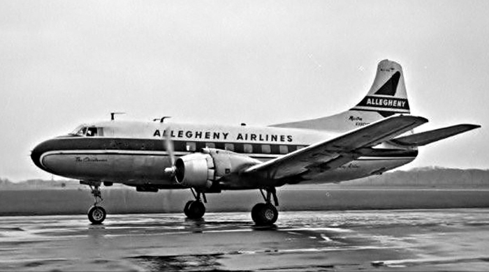
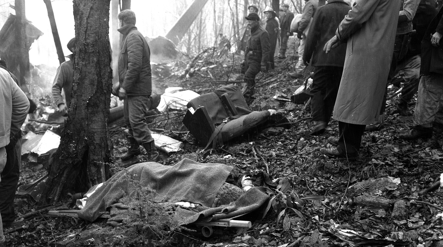
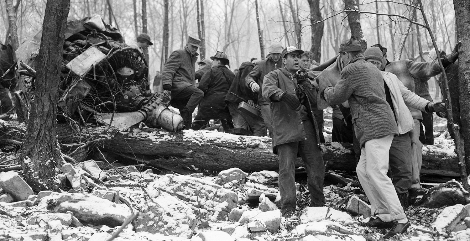
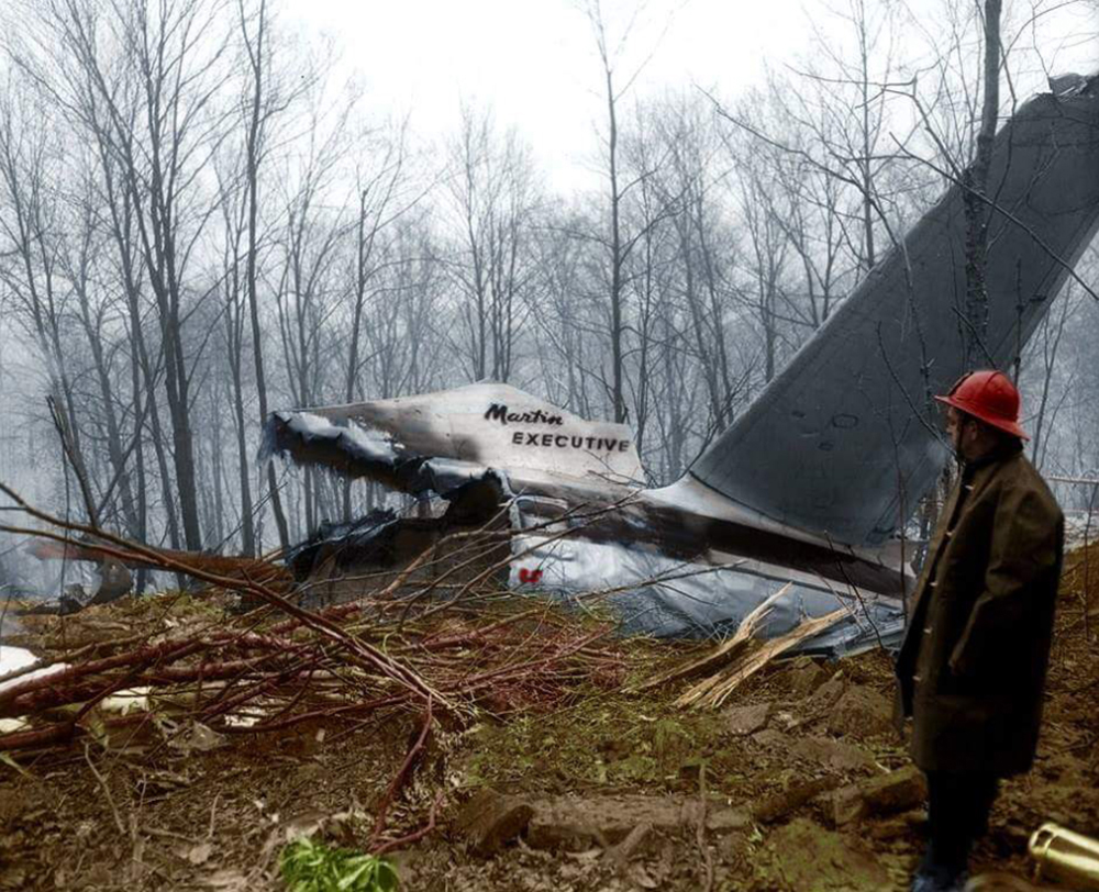
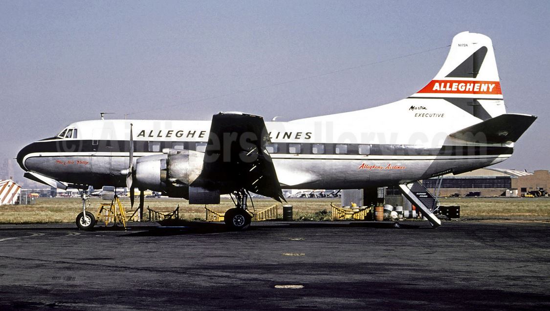
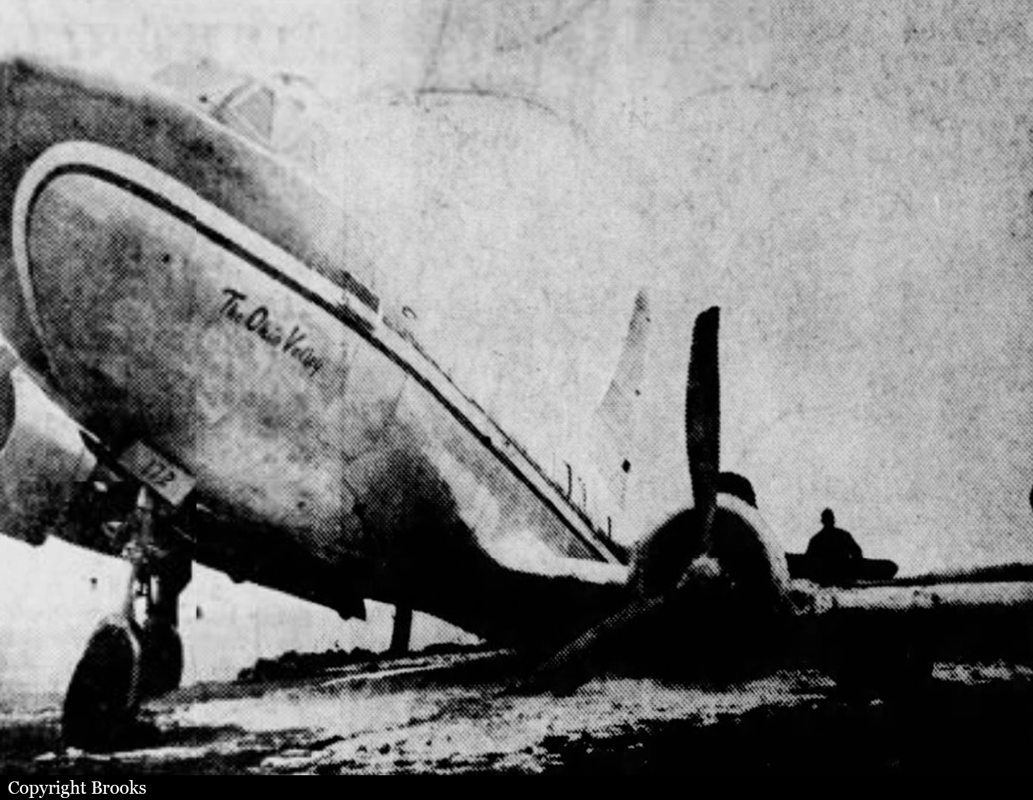
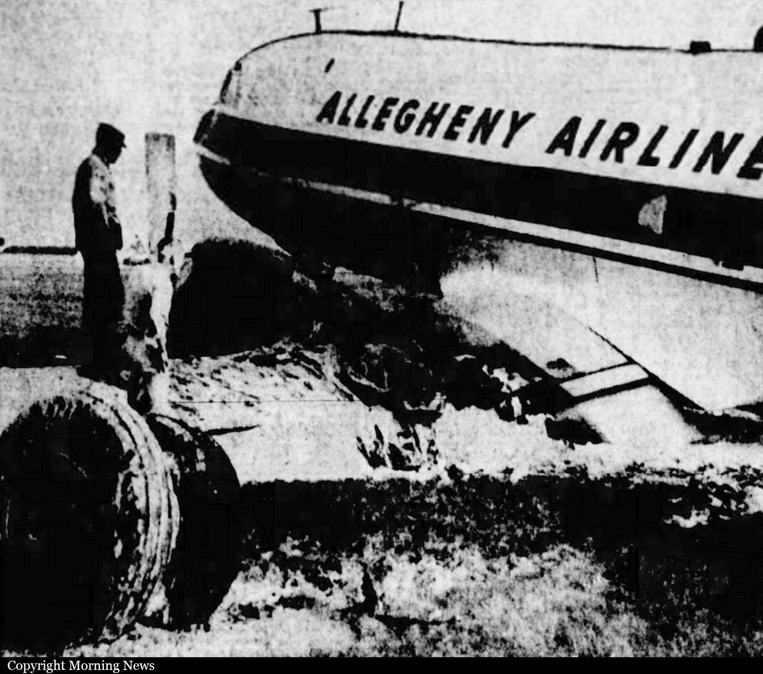
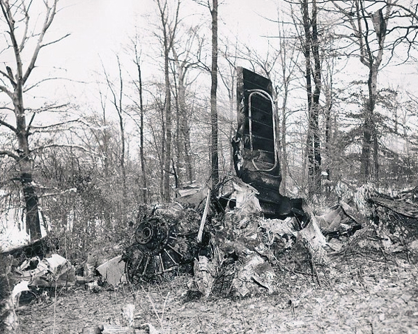
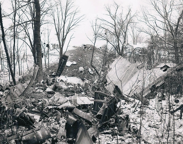
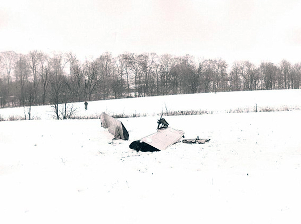
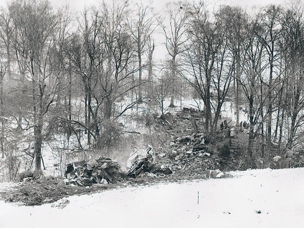
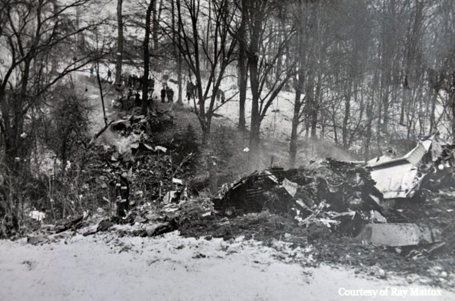
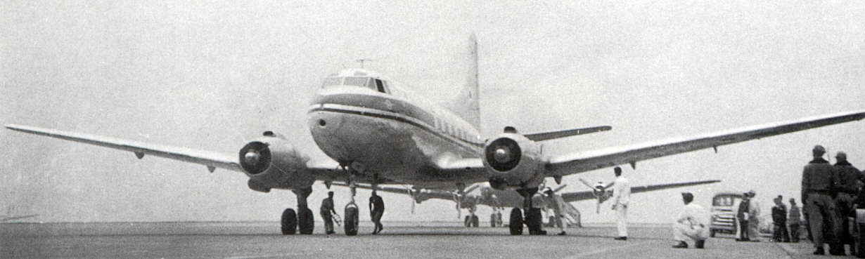
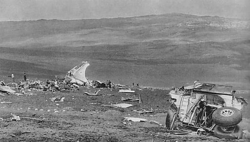
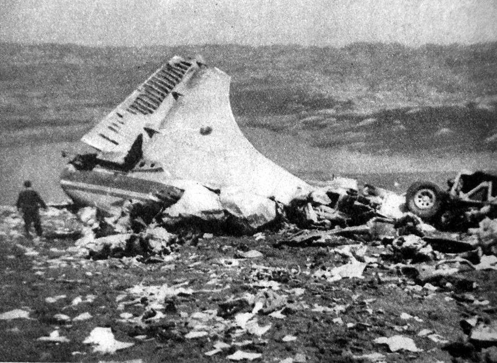
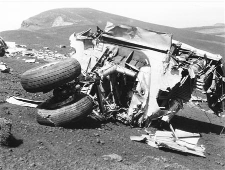
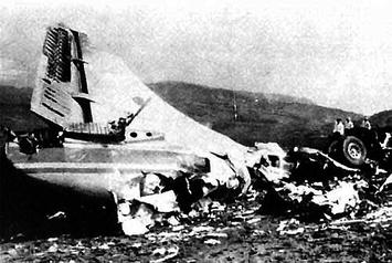
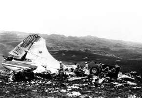
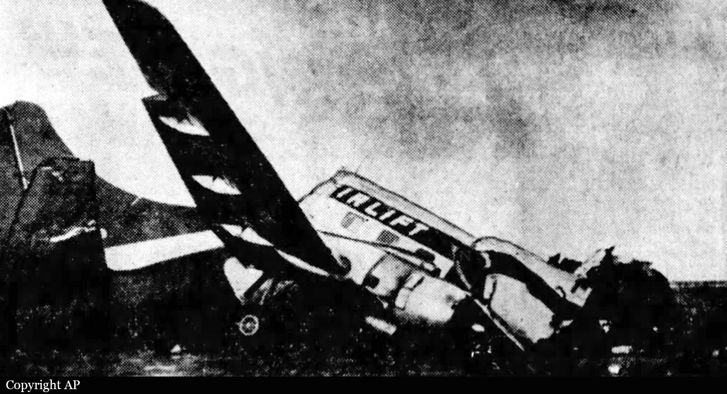
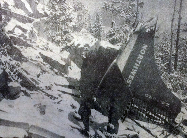
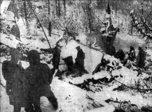
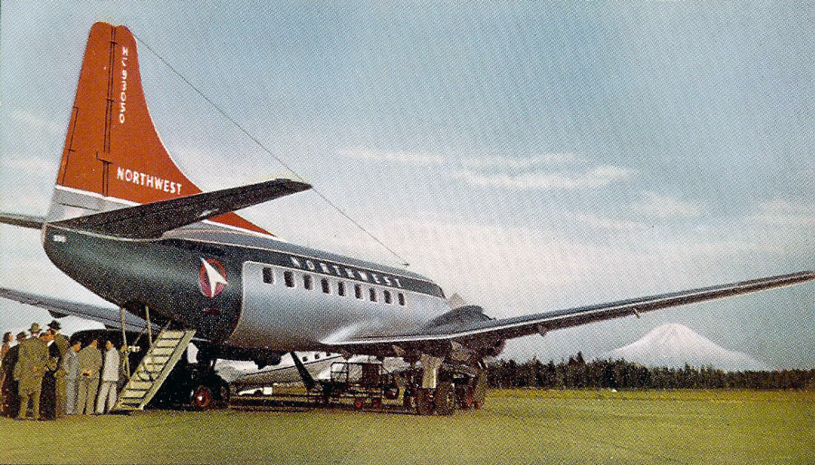
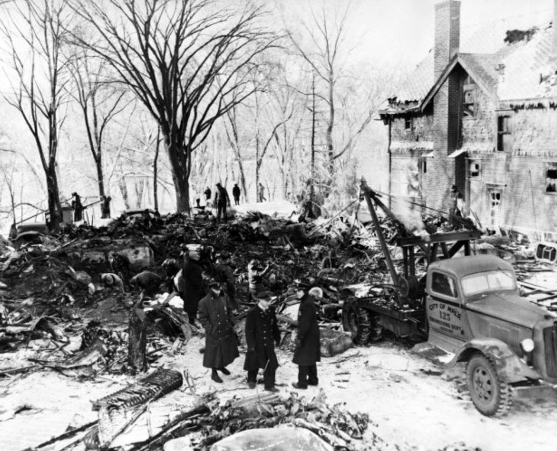
Flight 5763, a military contract flight, originated in Oakland, California, with Indiantown Gap, Pennsylvania, as its destination. It was scheduled to depart Oakland, California, at 0200, November 5, 1951, but due to a mechanical delay, departure was not made until 0352. The crew consisted of Captain Alec S. Hamilton, Copilot Henry N. Ingram, and Stewardess Frances B. Reilly. There were 26 passengers on board. The IFR (Instrument Flight Rules) flight plan filed with the CAA prior to departure indicated that the first intended landing would be Albuquerque, New Mexico, with Tucumcari, New Mexico, as the alternate. It showed a cruising altitude of 500 on top and an estimated time of Albuquerque of four hours and five minutes, with six hours and fifteen minutes of fuel on board. At the time of departure the aircraft weighed 38,939 pounds, which was within the allowable gross takeoff weight of 39,900 pounds; the load was properly distributed. The company maintains a dispatching office at Oakland to assist crews in planning flights, but it has no communications facilities for maintaining flight supervision. Company pilots are authorized to act as their own dispatchers, utilizing the CAA Communications facilities for the purpose of flight control. Captain Hamilton stated that prior to departure he was briefed by the U. S. Weather Bureau forecaster at the Oakland Airport on the an route weather and forecasts. Weather information available to the captain at this time indicated that there would be VFR (Visual Flight Rules) flying weather between Oakland and Albuquerque, at a cruising altitude of 11,000 feet, and that helping winds averaging 15 to 20 knots could be expected along the entire route. The forecast for Tucumcari, the alternate airport, indicated clear weather until 0500, followed by an overcast, with a ceiling of 800 feet and surface winds from the northeast at 15 miles per hour. The flight was routine and on reaching Acomita, New Mexico, at 0755, reported that it was 500 on top at 12,000 feet and was estimating Albuquerque at 0811. Following this report the flight asked to change its flight plan to Tucumcari with Amarillo, Texas, the alternate, and requested the latest Tucumcari weather which was: 0728, overcast, 1500 feet, visibility 20 miles, wind northeast 20 mph; Amarillo, 0728, broken clouds 1700 feet, overcast at 3500 feet, visibility 8 miles, wind north-northeast, 17 mph. The flight passed over Albuquerque under broken clouds in the clear at 12,000 feet NSL at 0813, whereupon the following clearance was given: “ARTC (Air Route Traffic Control) Clears CAM 5763 to the Tucumcari Airport via Green Airway No. 4, to maintain 500 on top while in the control area.” This clearance was acknowledged. At 0831, the flight reported being over Anton Chico, New Mexico, at 13,000 feet, estimating Tucumcari at 0852. At this time the 0828 Tucumcari weather was given the flight as; coiling estimated 1,000 feet, overcast, visibility 3 miles, snow and fog. At approximately 0845, Tucumcari radio gave 5763 the following clearance: “ARTC clears 5763 to descend to 8,000 feet on the south course of Tucumcari range, maintain 11,000 feet until 2 minutes south, descend outbound, maintain 8,000, report leaving 9,000.” The following clearance was transmitted to the flight by Tucumcari radio at 0851: “ARTC clears 5763 to approach Tucumcari Airport en reaching 8,000 feet.” The flight next reported being over the Tucumcari range station at 0852, at 11,000 feet, descending to 8,000 feet, and at 0901 reported that it was at 9,000 feet outbound on the south leg of the Tucumcari range. At this time the special 0852 Tucumcari weather report was given the flight: “Ceiling 800 feet, overcast, visibility one mile, light snow and fog, wind north 20 miles per hour with strong gusts.” The reported surface visibility in this official weather report was loss than the CAA and company minimums of 11/2 miles for the Tucumcari Airport. At 0907 5763 was given the following clearance: “ARTC clears 5763 to make standard instrument approach.” The Amarillo weather was then given as: coiling estimated 1,000 feet, broken clouds, overcast 2,000 feet; visibility 5 miles, light snow and fog. The flight was asked if it wished to proceed to Amarillo and it replied that it had to land at Tucumcari. The flight continued its descent and at 0909 was advised by Tucumcari radio that the Tucumcari weather was then ceiling 800 feet, overcast, visibility 1/2 miles, light snow and fog, wind north 20 miles per hour. Two minutes later, at 0911, the flight reported it was outbound on the west leg at 8,000 feet, descending to 6,000 feet. Tucumcari radio again gave the flight the weather which had been given it at 0908. One minute after this transmission Tucumcari radio gave the flight the wind direction which was then north-northwest, variable to north-northeast, at 16 miles per hour, and advised that Runway 30 was the runway in use. 5763 immediately requested the bearing of this runway and this was corrected to 03, which was acknowledged by the flight. At 0915 5763 reported that it was at 6,000 feet and inbound on the west leg of the Tucumcari range. Immediately following this report, at 0916, Tucumcari radio asked the flight if it wanted ARTC to recommend an alternate airport closer than Amarillo. The flight acknowledged this and advised it would have to land at Tucumcari but asked where the alternate would be. The pilot was advised to stand by and, according to the communicator on duty, the aircraft was then seen to cross the field in a northwesterly direction at very low altitude. The pilot was quickly advised to pull up and answered that he was doing so. At 0925, the flight advised it was landing downwind. This was the last report received from the flight. After several passes over the airport at altitudes varying from 500 feet to as low as 50 feet, the aircraft crashed near the northeast end of Runway 21 at approximately 0929. A flash fire which occurred immediately after impact quickly subsided. Ten passengers were injured and another one was killed. The aircraft was destroyed.
Probable cause:
The Board determines that the probable cause of this accident was the captain’s attempt to land during less than minimum visibility, rather than proceed to his alternate. The following findings were pointed out:
- The flight was routine until it arrived in the vicinity of Acomita, New Mexico, where the captain elected to change the existing flight plan and land at Tucumcari, with Amarillo as the new alternate,
- The weather at Albuquerque at that time was CAVU, whereas the weather at Tucumcari at the estimated time of the flight’s arrival there was forecast to be marginal,
- Prior to the change in flight plan the captain did not ask for now terminal forecasts as required, nor were they volunteered by Flight Assistance Service,
- During the approach to Tucumcari the surface visibility was transmitted to the flight as one mile and eight minutes later, one-half mile, the company’s prescribed visibility minimum is 11/2 miles,
- The captain did not execute a missed-approach and proceed to the alternate, but continued his attempts to land,
- Control of the aircraft was lost during a steep turn, and the left wing struck the ground.
Final Report:

Crash of a Martin 202 in Davenport: 10 killed

Date & Time: Jan 16, 1951 at 1214 LT
Type of aircraft:
Operator:
Registration:
N93054
Flight Phase:
Survivors:
No
Site:
Schedule:
Minneapolis – Billings – Spokane – Wenatchee – Seattle
MSN:
9144
YOM:
1948
Flight number:
NW115
Crew on board:
3
Crew fatalities:
Pax on board:
7
Pax fatalities:
Other fatalities:
Total fatalities:
10
Captain / Total flying hours:
4850
Captain / Total hours on type:
277.00
Copilot / Total flying hours:
692
Copilot / Total hours on type:
84
Aircraft flight hours:
5874
Circumstances:
At Spokane the aircraft was checked visually, and departed Geiger Field at 1204 with the same crew, seven passengers, and 800 gallons of fuel. The flight plan was under Instrument Flight Rules to cruise at 6,000 feet Mean Sea Level between Spokane and Wenatchee, Washington. At takeoff the aircraft’s total weight was 33,822 pounds, as compared with a maximum allowable of 37,780 pounds. The disposable load was distributed in such a manner that the aircraft’s center of gravity was within prescribed limits. Four minutes after takeoff, at 1208, the flight reported having reached the cruising level of 6,000 feet MSL at 1207. At 1212 it was given the Wenatchee weather which was below minima. The flight immediately asked clearance to the next scheduled stop, Yakima, where the weather was above minima. While the Spokane radio operator was obtaining the requested clearance, the flight broadcasted an emergency message. This was at about 1213, only some 15 seconds after asking for the new clearance. No difficulty of any sort had been reported previously. This emergency message was copied by company operators at Spokane, Yakima and Seattle. At the latter place it was also recorded on a magnetic tape by Aeronautical Radio, Inc., an independent radio organization serving several air carriers. The message was in three short sentences. All operators agree that the first was, “We are in trouble,” and that the last was, “Going down fast.” The middle sentence was interpreted by one operator as, “Plane gone nuts” and by the second as, “Right engine haywire.” The third operator put down a series of Q’s, meaning not understood. The actual context of the message will be discussed later in this reports. There was no further radio contact with the flight. At or about 1214 the aircraft crashed on the Pundy farm about three miles west of Reardan, Washington, and approximately 20 miles from Geiger Field. All aboard were killed. A flash fire followed impact and burning continued for some time at the end location throughout the wreckage area. Weather conditions during the short flight from Geiger Field to the impact site included restricted visibility due to light snow. At the flight level there was no icing or turbulence either forecast or reported. Instrument conditions prevailed at the flight’s altitude. At the place and time of the crash the ceiling was about 200 feet and the surface visibility about one-third mile.
Probable cause:
The Board, after extensive study of all evidence determines that the probable cause of this accident was a sudden loss of control for reasons unknown, resulting in rapid descent to the ground. The following items were reported:
- Weather was not contributory since there was no icing and little turbulence,
- The flight was uneventful until 30 to 90 seconds before the crash,
- A difficulty of undetermined origin resulted in loss of control and rapid descent to the ground,
- Examination of the wreckage remaining failed to disclose any evidence of structural failure and/or fire in flight.
Final Report:

Crash of a Martin 202 in Butte: 21 killed

Date & Time: Nov 7, 1950 at 0815 LT
Type of aircraft:
Operator:
Registration:
N93040
Survivors:
No
Schedule:
Chicago – Minneapolis – Billings – Great Falls – Helena – Butte – Seattle
MSN:
9161
YOM:
1947
Flight number:
NW115
Location:
Crew on board:
4
Crew fatalities:
Pax on board:
17
Pax fatalities:
Other fatalities:
Total fatalities:
21
Captain / Total flying hours:
8291
Captain / Total hours on type:
610.00
Copilot / Total flying hours:
2873
Copilot / Total hours on type:
80
Aircraft flight hours:
6166
Circumstances:
The flight left Helena at 0753LT, using Runway 29. The flight plan, amended before takeoff, specified an altitude of 10,500 feet MSL under instrument flight rules via Amber Airway number 2 to the Whitehall (Montana) Range Station and from there to the Butte Airport via Red Airway number 2. Also, before taking off, the pilot asked the Helena Tower if the Homestake Fan normally and was informed that Butte Radio advised that it was. Following takeoff from Runway 29, the aircraft was flown in a climbing right turn so that it passed approximately over the Station as it headed south toward the Whitehall Range Station. At 0801 the flight reported to Helena that it had reached its cruising altitude. This message was acknowledged. The next message from the flight was to Butte at 0814 stating that it was over Whitehall (Range Station) at 0811 and starting descent. Butte acknowledged this message, gave that flight the station altimeter setting of 29.97, advised that the wind was south, calm, and that the Weather Bureau advised what the ceiling was lower to the east and north and better to the south and southwest. Flight 115 replied that it had vertical visibility at 10,500 feet. This was the last radio contact with the flight. A search was instituted after several futile attempts to contact the aircraft. On the following morning, the wreckage was sighted from a local search aircraft at about 0900. Ground parties immediately started for the crash site. All debris were found in a snow covered wooded area and all 21 occupants were killed.
Probable cause:
The Board determines that the probable cause of this accident was the failure of the captain to conduct the flight in accordance with the proscribed approach procedure. The following findings were reported:
- The pilot failed to follows the carrier's prescribed number 2 instrument approach procedure to the Butte Airport, which procedure is approved by the Civil Aeronautics Administration,
- The aircraft struck a mountain at about the 8,250-foot level, while on a heading of approximately 290 degrees magnetic,
- The accident occurred during a local snowstorm and under conditions of variable ceiling and visibility.
Final Report:

Crash of a Martin 202 in Almelund: 6 killed

Date & Time: Oct 13, 1950 at 1049 LT
Type of aircraft:
Operator:
Registration:
NC93037
Flight Phase:
Flight Type:
Survivors:
No
Schedule:
Minneapolis - Minneapolis
MSN:
9158
YOM:
1947
Crew on board:
3
Crew fatalities:
Pax on board:
3
Pax fatalities:
Other fatalities:
Total fatalities:
6
Captain / Total flying hours:
9800
Captain / Total hours on type:
769.00
Copilot / Total flying hours:
8228
Copilot / Total hours on type:
368
Aircraft flight hours:
5289
Circumstances:
Northwest Airlines' NC93037 departed from the Minneapolis- St Paul International Airport at 0946LT on a local flight. The purpose of the flight was a six-month instrument competency check of Captain John R. Galt under the supervision of Captain Ray Render, a company cheek pilot. Also on board and listed as official observers were William H Solomon, CAA air carrier agent, who was sitting on the jump seat between and immediately behind the pilots' seats, and CAA personnel from the Minneapolis Control Tower, E. Bergstrom, R. Olsen and B. Erickson, who were sitting in the main cabin. At the time of takeoff there were 800 gallons of fuel on board which resulted in a total aircraft weight of 32,943 pounds. This weight was within the allowable limit of 38,000 pounds and the aircraft was properly loaded. The weather was clear and visibility was unlimited. Following takeoff, two simulated US (Instrument landing system) approaches were made to the airport and at 1025LT the crew radioed the control tower that this phase of the check flight was completed. This was the last known contact with the flight. After departing the Minneapolis area, the aircraft was first seen near Center City, Minnesota, 43 miles northwest of Minneapolis. At this time it was making a steep left turn at an altitude estimated to he between 4,000 and 5,000 feet, and landing gear was down. At the completion of this turn a shallow climb was started. Throughout these maneuvers the engines sounded as if they were operating in a normal manner. The attention of the ground witness was then diverted for a few moments, and when he again saw the aircraft it was in a partially inverted position and starting a steep dive. After losing approximately 2,500 feet in the dive, an apparently normal recovery was made to a level flight attitude and the aircraft proceeded in a northeasterly direction. Shortly thereafter it was seen to make two or three pitching oscillations about its lateral axis. These maneuvers may he described as a series of steps made by the aircraft as it was being lowered abruptly, followed by a recovery to level flight. During each oscillation approximately 400 feet in altitude was lost and a noise was heard such as is usually associated with a surge of engine power. The aircraft continued on a northeast heading. Two miles south of Almelund, Minnesota, which is 14 miles northeast of Center City, the aircraft was seen to make a shallow right turn of approximately 270 degrees and once more to return to a level attitude heading in a northwesterly direction. Throughout the above-mentioned maneuvers, the aircraft was gradually losing altitude, and the right propeller was observed to be turning slowly during the latter part of the flight. Nearing Almelund and at an altitude of approximately 500 or 600 feet above the ground, a steep right turn was begun. Altitude was lost rapidly and after turning approximately 90 degrees, the aircraft's right wing struck the ground. All but one of the six occupants were killed at impact, the injured person died several days later without regaining consciousness. The aircraft was demolished.
Probable cause:
The Board determines that the probable cause of this accident was the unwanted reversal of the right propeller during flight, as a result of which the crew was unable to maintain control of the aircraft. The following findings were reported:
- The fuel feed valve of the right engine malfunctioned when tested,
- The right propeller was found in 7 degrees to 10 degrees of reverse thrust,
- A review of the evidence of a similar occurrence indicated that with a propeller in the reverse thrust position the aircraft would assume dangerous flight characteristics,
- The fact that the aircraft's wing flaps were retracted may have contributed to the uncontrollability of the aircraft at speeds below 140 miles per hour.
Final Report:

Crash of a Martin 202 in Minneapolis: 15 killed

Date & Time: Mar 7, 1950 at 2059 LT
Type of aircraft:
Operator:
Registration:
NC93050
Survivors:
No
Schedule:
Washington-Detroit-Madison-Rochester-Minneapolis-Winnipeg
MSN:
9134
YOM:
1948
Flight number:
NW307
Crew on board:
3
Crew fatalities:
Pax on board:
10
Pax fatalities:
Other fatalities:
Total fatalities:
15
Captain / Total flying hours:
7619
Captain / Total hours on type:
988.00
Copilot / Total flying hours:
2432
Copilot / Total hours on type:
585
Circumstances:
The aircraft departed Washington DC at 1230LT destined for Winnipeg, Manitoba, Canada, with intermediate stops in Detroit, Rochester, Madison and Minneapolis. With the exception of an hour and 23 minute delay at Detroit, required for the replacement of a ring seal in the hydraulic system, the flight proceeded in air routine manner to Madison, Wisconsin After arrival at Madison the aircraft was serviced with 1,010 gallons of fuel and 38 gallons of oil. Also on board were 10 passengers and 1,799 pounds of cargo which resulted in an aircraft weight of 36,842 pounds. This weight was well within the allowable limit of 39,100 pounds, and so far as is known, the aircraft was properly loaded. Weather information available to the flight prior to its departure from Madison showed that Rochester, 75 miles south southeast of Minneapolis, was reporting a ceiling of 700 feet with visibility of five miles, and that Minneapolis was reporting a ceiling of 900 feet with visibility of 1/2 mile 3. In addition, there was fog and blowing snow at these stations. Turbulence was expected in the clouds, and icing above the freezing level of 8,000 feet. The trip was planned to Minneapolis at an altitude of 4 000 feet, the schedule stop at Rochester being made contingent upon weather conditions at the time of the flight’s arrival. Madison, Wis., and Jamestown, N. Dak where weather conditions were well above landing minimums, were designated as alternate airports. Flight 307 arrived over Rochester at 2023, and because there was light freezing rain, did not land. Twelve minutes later the flight made a routine report to company radio that it was over Stanton which is a radio beacon 30 miles south of the Twin Cities Airport at Minneapolis, and at 2041 contacted Minneapolis Approach Control for landing clearance. The tower advised Flight 307 of existing, weather conditions. There was a precipitation ceiling of 900 feet, visibility was variable 1/2 to 3/4 of a mile, and the wind was from the north 27 miles per hour with gusts up to 40 miles per hour. The tower informed the flight that there had been two electric power failures at the field, and that if no further communication were received from the tower, it would be in all probability the result of another power failure The flight was also told that the ILS was serviceable, but that it had not been flight checked. As Flight 307 approached, another NWA flight, a Boeing 377, was standing at the approach end of the instrument runway, Runway 35, checking engines prior to flight Takeoff clearance was given to the Boeing 377. When it had proceeded half-way down the runway, Flight 307 reported that it was over the outer marker, which was 4.7 miles south of the approach end of the runway. The high intensity runway lights were increased in intensity, their coning device was set to 1/2 mile, the prevailing visibility at the time, and Flight 307 was cleared to land. Flight 307 was not seen from the tower during its approach, but it was heard to pass overhead at which time the controllers received the call, “I have got to get in Clearance was again given to land, following which the flight advised that it would climb to 2,400 feet on the northwest course of the Minneapolis radio range. After a pause, the flight transmitted. “We are going in-we are going in.” After the aircraft had flown over the field, it was observed flying straight and level 3.8 miles northwest of the airport. A wing was seen to fall. Then, the aircraft was observed to dive almost vertically from an altitude of about 300 feet, and crash into a residence in the city of Minneapolis Fire which started immediately after the crash consumed the house and much of the aircraft wreckage. All of the 13 occupants of the aircraft and two of the occupants of the house were killed.
Probable cause:
The Board determines that the probable cause of this accident was the attempt to complete a landing approach by visual means during which time visual reference to the ground was lost.
The following findings were noted:
- Weather conditions were precipitation ceiling, 900 feet, visibility 1/2 mile variable reduced by blowing snow wind from the north at 27 miles an hour with gusts to 40 miles per hour air, cold and dry, and, turbulence over the lending approach flight path,
- During the period preceding and following the accident slant visibility was relatively good, which permitted other flights to complete their landing approaches by visual reference to the runway,
- Flight 307 was flown 128 feet below the ILS glide path and 650 feet to the left of the localizer at a point 4,180 feet south from the approach end of Runway 35 where the aircraft struck a flagpole well marked by red neon obstruction lights.
Final Report: