

Zone
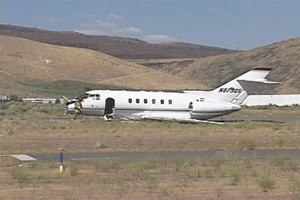
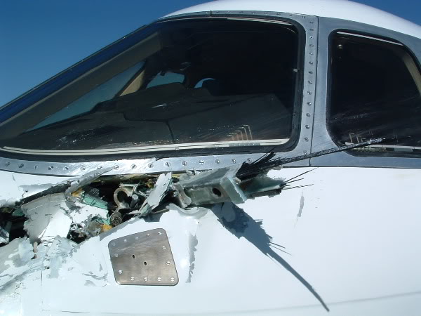
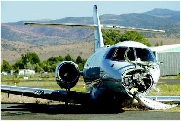
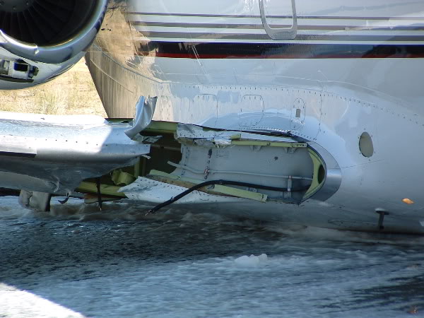
Crash of a Hawker 800XP in Carson City
Date & Time:
Aug 28, 2006 at 1506 LT
Operator:

Registration:
N879QS
Survivors:
Yes
Schedule:
Carlsbad – Reno
MSN:
258379
YOM:
1998
Crew on board:
2
Crew fatalities:
Pax on board:
3
Pax fatalities:
Other fatalities:
Total fatalities:
0
Captain / Total hours on type:
1564.00
Copilot / Total hours on type:
548
Aircraft flight hours:
6727
Circumstances:
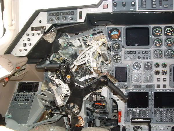
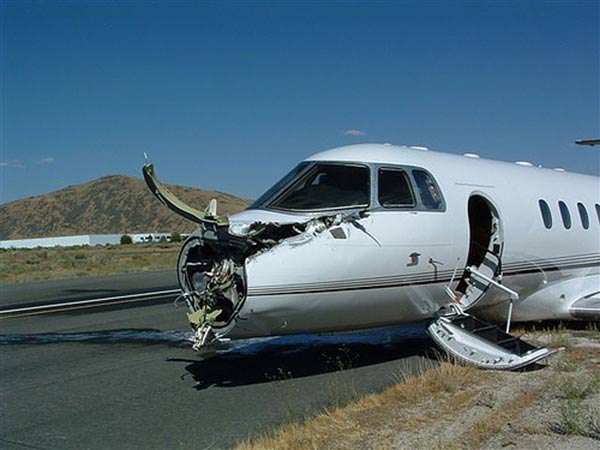
The Hawker and the glider collided in flight at an altitude of about 16,000 feet above mean sea level about 42 nautical miles south-southeast of the Reno/Tahoe International Airport (RNO), Reno, Nevada, which was the Hawker's destination. The collision occurred in visual meteorological conditions in an area that is frequently traversed by air carrier and other turbojet airplanes inbound to RNO and that is also popular for glider operations because of the thermal and mountain wave gliding opportunities there. Before the collision, the Hawker had been descending toward RNO on a stable northwest heading for several miles, and the glider was in a 30-degree, left-banked, spiraling climb. According to statements from the Hawker's captain and the glider pilot, they each saw the other aircraft only about 1 second or less before the collision and were unable to maneuver to avoid the collision in time. Damage sustained by the Hawker disabled one engine and other systems; however, the flight crew was able to land the airplane. The damaged glider was uncontrollable, and the glider pilot bailed out and parachuted to the ground. Because of the lack of radar data for the glider's flight, it was not possible to determine at which points each aircraft may have been within the other's available field of view. Although Federal Aviation Regulations (FARs) require all pilots to maintain vigilance to see and avoid other aircraft (this includes pilots of flights operated under instrument flight rules, when visibility permits), a number of factors that can diminish the effectiveness of the see-and-avoid principle were evident in this accident. For example, the high closure rate of the Hawker as it approached the glider would have given the glider pilot only limited time to see and avoid the jet. Likewise, the closure rate would have limited the time that the Hawker crew had to detect the glider, and the slim design of the glider would have made it difficult for the Hawker crew to see it. Although the demands of cockpit tasks, such as preparing for an approach, have been shown to adversely affect scan vigilance, both the Hawker captain, who was the flying pilot, and the first officer reported that they were looking out the window before the collision. However, the captain saw the glider only a moment before it filled the windshield, and the first officer never saw it at all.
Probable cause:
The failure of the glider pilot to utilize his transponder and the high closure rate of the two aircraft, which limited each pilot's opportunity to see and avoid the other aircraft.
Final Report:


Crash of a Rockwell Shrike Commander 500S near Eagleville: 5 killed
Date & Time:
Nov 21, 2001 at 1126 LT
Registration:
N900RA
Survivors:
No
Schedule:
Reno - Wenatchee
MSN:
500-3070
YOM:
1970
Crew on board:
1
Crew fatalities:
Pax on board:
4
Pax fatalities:
Other fatalities:
Total fatalities:
5
Aircraft flight hours:
8101
Circumstances:
The airplane collided with mountainous terrain during cruise after encountering turbulence and downdrafts associated with mountain wave conditions. According to Federal Aviation Administration (FAA) records, the pilot called the Reno Automated Flight Service Station at 0941 and filed an IFR flight plan, then asked for the winds aloft forecast, which was provided. The pilot did not request any additional weather briefing information for the flight. No other record was found that the pilot obtained additional weather forecast information from any official source associated with the FAA or the National Weather Service. At the time of the pilot's call to the Reno AFSS, several AIRMET weather advisories had been issued hours prior detailing warnings for turbulence and clear icing along the route of flight. The advisories warned of occasional moderate turbulence below 18,000 feet in moderately strong westerly winds especially in the vicinity of mountainous terrain. Clear Air Turbulence (CAT) between 18,000 and 40,000 feet was forecast over the area of the accident site due to jet stream wind shear and mountain wave activity. The pilot departed under visual flight rules (VFR) and picked up his instrument flight rules (IFR) clearance en route and climbed to 14,000 feet. The pilot later asked if he could maintain 12,500 feet. The controller advised him that the minimum IFR altitude on this segment of his route was 14,000 feet, and the pilot cancelled his IFR flight plan. The controller advised the pilot that he had lost radar contact, and instructed the pilot to squawk VFR and the pilot acknowledged the transmission. The last radar target was about 1/2 mile east of Eagle Peak (elevation 9,920 feet) in the Warner Mountains. Rescuers discovered the wreckage near the crest of Eagle Peak on November 23. Investigators found no anomalies with the airframe, engines, or propellers that would have precluded normal operation. The NWS had a full series of AIRMETs current over the proposed route of flight, which included mountain obscuration, turbulence, and icing. Analysis of the weather conditions disclosed a layer between 9,500 and 11,000 feet over the accident site area as having a high likelihood of severe or greater turbulence. A pilot on the same route of flight reported at 1127 that he was in instrument conditions at 11,000 feet, and experiencing light turbulence and light clear icing conditions. He also reported encountering updrafts of 2,000 feet per minute, which was indicative of mountain wave activity. A company pilot was in a second Aero Commander trailing the accident airplane and he reported that at 1147, at a position near the accident site, he encountered a severe downdraft. He applied full climb power, but as the airplane passed over the accident site position, the airplane continued to lose altitude even at maximum power. At 1159, he was able to gain altitude, and return to his assigned cruising altitude of 14,000 feet. The second Aero Commander was turbocharged, the accident airplane was not. Analysis showed that the topography of the area was critical in this case, given that the accident site was at an elevation of 9,240 feet on the eastern slope of Eagle Peak. The accident airplane's flight track was normal along the airway until immediately downwind of the higher terrain. As the flight approached the lee side of the mountain, it came under the influence of the mountain wave and first encountered an updraft and then a downdraft, which increased in amplitude as the flight progressed towards Eagle Peak. Eagle Peak was the tallest point along the Warner Mountain range and the steep slope of this terrain was significant when the mountain wave action was encountered. Such terrain features have been known to enhance the vertical downdrafts and updrafts associated with the most intense mountain wave turbulence.
Probable cause:
The pilot's encounter with forecast mountain wave conditions, moderate or greater turbulence, and icing, with downdrafts that likely exceeded the climb capability of the airplane, which was encountered at an altitude that precluded recovery. Also causal in the accident was the failure of the pilot to obtain an adequate preflight weather briefing which would have included a series of Airmets that were in effect at the time.
Final Report:
Crash of a Cessna 402C in Walker: 1 killed
Date & Time:
Jan 17, 1998 at 1230 LT
Operator:

Registration:
N114GP
Survivors:
Yes
Schedule:
Reno - Columbia
MSN:
402C-0085
YOM:
1979
Crew on board:
1
Crew fatalities:
Pax on board:
1
Pax fatalities:
Other fatalities:
Total fatalities:
1
Captain / Total hours on type:
722.00
Aircraft flight hours:
16731
Circumstances:
The aircraft collided with trees and mountainous terrain about 9,500 feet msl. The wreckage was spread across the lee side of a mountain, in a grassy meadow surrounded by high mountainous terrain on all sides. The area, about 100 feet in front of the aircraft, was a rocky embankment which sloped upward approximately 30 degrees. About 100 feet from the tail of the aircraft, the terrain dropped off into a steep cliff, which sloped down about 65 degrees. At the base of the cliff was a valley, which was about 1/4 mile wide. The farthest piece of debris was found 410 feet away from the main wreckage site in a grove of trees. Fifteen tree disturbances were noted in the grove. The first disturbance began near the tops of the trees and continued in a descending path. Much of the airframe exhibited semicircular impressions consistent with the trunk diameters of the disturbed trees at the accident site. Organic material transfer was evident in the impressions. An analysis of the meteorological data showed that a clear or scattered cloud condition was likely in the accident area, and visibility was probably unrestricted. It also showed that an extended north-northwestward/south-southeastward cloud band was located over the Sierra Nevada Mountains about 9 to 10 miles southwest through west of the accident location around the time of the accident. The analysis estimated that the winds aloft at 10,000 to 12,000 feet msl in the mountains were from approximately 270 degrees at 40 to 45 knots. Further, moderate or greater turbulence and strong updrafts and downdrafts were reported along the pilot's route of flight. No mechanical discrepancies were found with the airframe or either engine during the postaccident examination.
Probable cause:
The pilot's encounter with a downdraft while approaching high terrain at an altitude insufficient to ensure adequate terrain or obstacle clearance.
Final Report:
Crash of a Rockwell Grand Commander 690 in Herlong: 2 killed
Date & Time:
Dec 31, 1992 at 1536 LT
Registration:
N300CP
Survivors:
No
Schedule:
Reno - Susanville
MSN:
690-11374
YOM:
1977
Crew on board:
1
Crew fatalities:
Pax on board:
1
Pax fatalities:
Other fatalities:
Total fatalities:
2
Captain / Total hours on type:
782.00
Aircraft flight hours:
4052
Circumstances:
The pilot and flight nurse were en route to pick up a medical patient. The airplane experienced an in-flight breakup while flying by the leeward side of the sierra nevada mountains in the general area where standing lenticular clouds had been observed. No evidence was found that the pilot obtained a weather briefing from flight service or the duat vendors prior to departure. Pilots flying in the general area had reported airspeed variances from plus 60 to minus 40 knots. An in-flight weather advisory for occasional moderate turbulence was in effect. About one hour after the accident the weather service issued a sigmet for severe turbulence. Cause: an inadvertent encounter with severe turbulence which exceeded the design strength of the airplane's structure. Both occupants were killed.
Crash of a Piper PA-31-325 Navajo C/R near Cedar City: 4 killed
Date & Time:
Apr 25, 1990 at 2230 LT
Registration:
N18PP
Survivors:
No
Schedule:
Denver - Reno
MSN:
31-7512046
YOM:
1975
Crew on board:
1
Crew fatalities:
Pax on board:
3
Pax fatalities:
Other fatalities:
Total fatalities:
4
Aircraft flight hours:
2260
Circumstances:
The pilot reported to ATC that he intended to make an unscheduled fuel stop. ATC advised that Cedar City Airport was 15 minutes away. Radar vectors were requested and were issued. Although dark night conditions existed and the pilot controlled airport lighting was never activated, the pilot reported the airport in sight and was cleared for a visual approach. Three minutes later radar contact was lost. Impact occurred in mountainous terrain at 9,100 feet elevation about six miles east of the 5,622 foot elevation airport. Minimum safe altitude was 12,400 feet. All four occupants were killed.
Probable cause:
The pilot failed to maintain a minimum safe altitude over mountainous terrain during a night VFR approach for landing.
Final Report:
Crash of a Piper PA-61 Aerostar (Ted Smith 601) in Lakeview: 3 killed
Date & Time:
Mar 4, 1989 at 1200 LT
Registration:
C-FHGH
Survivors:
No
Schedule:
Portland - Reno
MSN:
61-0829-8163438
YOM:
1981
Crew on board:
1
Crew fatalities:
Pax on board:
2
Pax fatalities:
Other fatalities:
Total fatalities:
3
Captain / Total hours on type:
108.00
Aircraft flight hours:
1297
Circumstances:
While en route, the pilot encountered headwinds and trace rime icing. He made a climb from 17,000 feet to FL190, then to FL210. After cruising at FL210 for about 27 minutes, the aircraft entered a descent (without ATC clearance). Radio and radar contact were lost in the vicinity of were the aircraft crashed. Just before impact, the aircraft was observed to descend out of low clouds in a spin. The pilot had been issued a Canadian instrument rating on 1/11/88, but it was valid for only 12 months. A person, who had given the pilot proficiency flight training in preparation for an instrument qualification check, reported that he had reservations about the pilot's ability to fly in instrument conditions without an autopilot. Avionics personnel at the departure airport reported the pilot had encountered an autopilot malfunction on the previous flight and that they had found an electrical short in the autopilot disconnect switch on the copilot control yoke. However, they were unable to repair it due to lack of a replacement part. Reportedly, the pilot borrowed a soldering iron to repair it himself. All three occupants were killed.
Probable cause:
Failure of the pilot to maintain control of the aircraft, which resulted in a spin and an uncontrolled descent. Factors related to the accident were: improper maintenance by the pilot, an autopilot malfunction, the adverse weather conditions, continued flight by the pilot into adverse weather conditions, and his lack of recent instrument experience.
Final Report:
Crash of a Cessna 208A Caravan I near Travis AFB: 1 killed
Date & Time:
Oct 23, 1987 at 0423 LT
Operator:

Registration:
N828FE
Survivors:
No
Schedule:
Oakland - Reno
MSN:
208-0073
YOM:
1985
Crew on board:
1
Crew fatalities:
Pax on board:
0
Pax fatalities:
Other fatalities:
Total fatalities:
1
Captain / Total hours on type:
642.00
Aircraft flight hours:
1721
Circumstances:
While cruising on a scheduled cargo flight in IMC the pilot encountered moderate to severe turbulence near an area where weather cells could have been observed on the aircraft's radar. The pilot reversed course, declared an emergency and lost control of the aircraft. The aircraft entered an uncontrolled descent, collided with terrain and was destroyed. The recently hired pilot had completed the FAA approved ground and flight training program in the aircraft. During the pilot's recent training, neither the FAA nor the operator required the pilot to demonstrate proficiency in unusual attitude recoveries or have knowledge in the operation of the aircraft's weather radar. Company employees, which included the pilot's husband, stated that the pilot had no previous experience with weather radar and did not understand the weather radar installed in this aircraft. They further stated that the pilot appeared to be tired. The pilot, sole on board, was killed.
Probable cause:
The National Transportation Safety Board determines the probable cause(s) of this accident to be:
Pilot's encounter with severe turbulence which precipitated a loss of Aircraft control.
Findings
Occurrence #1: in flight encounter with weather
Phase of operation: cruise - normal
Findings
1. Light condition - dark night
2. (f) weather condition - turbulence in clouds
3. (f) weather radar - not understood - pilot in command
4. (f) inadequate initial training - company/operator management
5. (f) inadequate initial training - faa (principal operations inspector)
6. (c) flight into known adverse weather - continued - pilot in command
----------
Occurrence #2: loss of control - in flight
Phase of operation: maneuvering - turn to reverse direction
Findings
7. (c) spiral - uncontrolled - pilot in command
8. (f) spatial disorientation - pilot in command
9. (f) fatigue (lack of sleep) - pilot in command
----------
Occurrence #3: in flight collision with terrain/water
Phase of operation: descent - uncontrolled
Final Report:
Crash of a Rockwell Grand Commander 690 in Bridgeport: 2 killed
Date & Time:
Jun 21, 1987 at 0133 LT
Operator:

Registration:
N662DM
Survivors:
No
Schedule:
Reno - Bridgeport
MSN:
690-11015
YOM:
1972
Crew on board:
1
Crew fatalities:
Pax on board:
1
Pax fatalities:
Other fatalities:
Total fatalities:
2
Captain / Total hours on type:
34.00
Aircraft flight hours:
5234
Circumstances:
The flight conditions for the air ambulance trip consisted of a clear, moonless, dark night and the destination airport was in a mountain valley with the only ground reference lights the town adjacent to the airport. Witnesses saw the aircraft overfly the town and airport at pattern altitude then head out over the lake north of the airport. About 1 mile from the runway, the aircraft was seen to suddenly pitch up, roll inverted and dive straight down into the lake (Bridgeport Reservoir). The aircraft was heading away from the only ground reference lights and was over a reflective body of water near the base turn point when the accident occurred. Witnesses heard increased eng/prop noise before impact. Wreckage revealed evidence of power at impact. The shifts for the pilots in the operation consisted of 4 days on, 2 days off, with alternating day and night shifts. The pilot was on the 4th night of the current shift cycle and was also giving flight instruction during the days. Both occupants, a pilot and a nurse, were killed.
Probable cause:
Occurrence #1: loss of control - in flight
Phase of operation: approach - vfr pattern - base leg/base to final
Findings
1. (f) light condition - dark night
2. (f) visual lookout - inadequate - pilot in command
3. (c) flight controls - inadvertent use - pilot in command
4. (c) proper altitude - not maintained - pilot in command
5. (c) visual/aural perception - pilot in command
6. (c) spatial disorientation - pilot in command
7. (f) fatigue (circadian rhythm) - pilot in command
8. (f) fatigue (flight and ground schedule) - pilot in command
9. (f) insuff standards/requirements, operation/operator - company/operator mgmt
----------
Occurrence #2: in flight collision with terrain/water
Phase of operation: descent - uncontrolled
Findings
10. (f) descent - uncontrolled - pilot in command
Final Report:
Crash of a Piper PA-31-350 Navajo Chieftain in Sparks
Date & Time:
Aug 15, 1985 at 2247 LT
Registration:
N27476
Survivors:
Yes
Schedule:
Ely - Reno
MSN:
31-7852022
YOM:
1978
Crew on board:
1
Crew fatalities:
Pax on board:
2
Pax fatalities:
Other fatalities:
Total fatalities:
0
Captain / Total hours on type:
105.00
Aircraft flight hours:
1926
Circumstances:
The aircraft exhausted fuel enroute to destination during cross country night flight. The pilot advised ATC of loss of engines about 20 miles out. The pilot made deadstick landing on highway, struck bridge divider. No fire or reported injuries. Inspection disclosed dry fuel tanks.
Probable cause:
Occurrence #1: loss of engine power (total) - nonmechanical
Phase of operation: cruise
Findings
1. (c) aircraft preflight - inadequate - pilot in command
2. (f) fuel supply - misjudged - pilot in command
----------
Occurrence #2: forced landing
Phase of operation: landing
----------
Occurrence #3: in flight collision with terrain/water
Phase of operation: landing - flare/touchdown
Final Report:

