Country
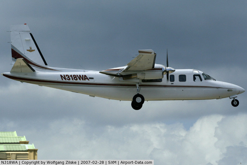
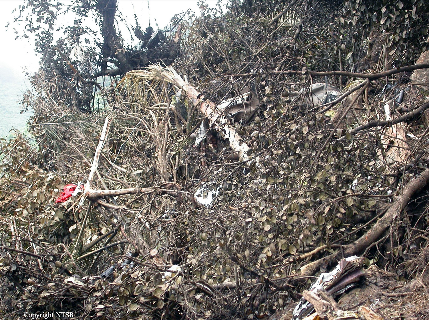
Crash of a Rockwell Grand Commander 690B in the El Yunque National Forest: 3 killed
Date & Time:
Dec 3, 2008 at 1205 LT
Operator:

Registration:
N318WA
Survivors:
No
Schedule:
Tortola – San Juan
MSN:
690-11444
YOM:
1978
Crew on board:
1
Crew fatalities:
Pax on board:
2
Pax fatalities:
Other fatalities:
Total fatalities:
3
Aircraft flight hours:
5286
Circumstances:
The charter flight departed for the destination, where the passengers would connect with another airline flight. The instrument-rated pilot may have felt pressured as the flight departed late. The accident airplane approached the destination airport from the east, descending at 250 knots ground speed from 8,800 feet above mean sea level (msl), on a 270 degree assigned heading, and was instructed to enter the right downwind for runway 10. The airplane's altitude readout was then observed by the approach controller to change to "XXX." The pilot was queried regarding his altitude and he advised that he was descending to 3,200 feet msl. The pilot was asked to confirm that he was in visual flight rules (VFR) conditions and was advised that the minimum vectoring altitude (MVA) for the area was 5,500 feet msl. The pilot responded that “We just ahh,” at which time the controller advised that she missed his transmission and asked him to repeat it. The pilot stated “Ahh roger, could we stay right just a little, we are in and out of some clouds right now.” The controller advised the pilot to “Maintain VFR” and again of the MVA. The controller then made multiple attempts to contact the pilot without result. The wreckage was discovered on the side of a mountain, where the airplane impacted after entering instrument meteorological conditions. Because aircraft operating in VFR flight are not required to comply with minimum instrument altitudes, aircraft receiving VFR radar services are not automatically afforded Minimum Safe Altitude Warning services except by pilot request. The controller's query to the pilot about his altitude and flight conditions was based on her observation of the loss of altitude reporting information. The pilot had not indicated any difficulty in maintaining VFR flight or terrain clearance up to that point. His comment that the aircraft was "in and out of some clouds" was her first indication that the pilot was not operating in visual conditions, and came within seconds of impact with the terrain. The controller was engaged in trying to correct the situation, and despite having been advised of the minimum vectoring altitude, the pilot continued to descend. The airplane was equipped with a terrain avoidance warning system but it could not be determined if it was functional. The pilot owned the charter operation. Documents discovered in the wreckage identified the pilot and airplane as operating for a different company since the pilot did not have the permissions necessary to operate in the United Kingdom Overseas Territories.
Probable cause:
The pilot's continued visual flight into instrument meteorological conditions, which resulted in an in-flight collision with terrain.
Final Report:

Crash of a Rockwell Grand Commander 690A in Valledupar: 4 killed
Date & Time:
Jan 13, 2007 at 2122 LT
Operator:

Registration:
YV-246CP
Survivors:
No
Schedule:
Maracaibo – Panama City
MSN:
690-11278
YOM:
1976
Crew on board:
1
Crew fatalities:
Pax on board:
3
Pax fatalities:
Other fatalities:
Total fatalities:
4
Captain / Total hours on type:
781.00
Aircraft flight hours:
8197
Circumstances:
The twin engine aircraft departed Maracaibo Airport on a charter flight to Panama City with three passengers and one pilot on board. While cruising over the Sierra de Perija between Venezuela and Colombia, the pilot informed ATC about technical problems. Shortly later, the aircraft entered an uncontrolled descent and crashed in a mountainous terrain near Valledupar, bursting into flames. All four occupants were killed.
Probable cause:
The exact cause of the loss of control could not be determined.
Final Report:


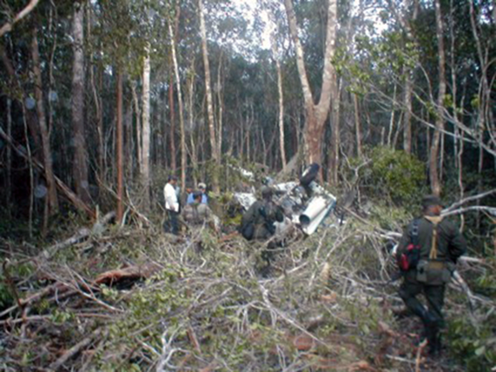
Crash of a Rockwell Grand Commander 690A near Antlers: 4 killed
Date & Time:
Oct 15, 2006 at 1303 LT
Registration:
N55JS
Survivors:
No
Schedule:
Oklahoma City - Orlando
MSN:
690-11195
YOM:
1974
Crew on board:
2
Crew fatalities:
Pax on board:
2
Pax fatalities:
Other fatalities:
Total fatalities:
4
Captain / Total hours on type:
150.00
Aircraft flight hours:
7943
Circumstances:
Approximately 37 minutes after departing on a 928-nautical mile cross-country flight under instrument flight rules, the twin-engine turboprop airplane experienced an in-flight break-up after encountering moderate turbulence while in cruise flight at the assigned altitude of FL230. In the moments preceding the break-up, the airplane had been flying approximately 15 to 20 knots above the placarded maximum airspeed for operations in moderate turbulence. The airplane was found to be approximately 1,038 pounds over the maximum takeoff weight listed in the airplane's type certificate data sheet (TCDS). The last radar returns indicated that the airplane performed a 180-degree left turn while descending at a rate of approximately 13,500 feet per minute. There were no reported eyewitnesses to the accident. The wreckage was located the next day in densely wooded terrain. The wreckage was scattered over an area approximately three miles long by one mile wide. An examination of the airframe revealed that the airplane's design limits had been exceeded, and that the examined fractures were due to overload failure.
Probable cause:
The pilot's failure to reduce airspeed while operating in an area of moderate turbulence, resulting in an in-flight break up. Contributing factors were the pilot's decision to exceed the maximum takeoff weight, and the prevailing turbulence.
Final Report:

Crash of a Rockwell Grand Commander 690A off Anchorage: 3 killed
Date & Time:
Jul 28, 2006 at 2037 LT
Registration:
N57096
Survivors:
No
Schedule:
Kenai - Anchorage
MSN:
690-11120
YOM:
1973
Crew on board:
2
Crew fatalities:
Pax on board:
1
Pax fatalities:
Other fatalities:
Total fatalities:
3
Aircraft flight hours:
11340
Circumstances:
The crew of the missing airplane was conducting a local area familiarization flight under Title 14, CFR Part 91. At the time of the flight, visual meteorological conditions prevailed, with occasional moderate turbulence forecast for the area. The airplane was routinely contracted for animal and bird counts, and the flight was to include low level flight simulating such a mission. The three occupants of the airplane were the pilot, company check pilot, and another company pilot riding along as a passenger. Both the pilot and the check pilot held airline transport certificates, and were experienced in the make and model of the accident airplane. The airplane was equipped with a satellite position reporting device that updated position, groundspeed, and altitude every 2 minutes. Radar and GPS track information indicated the accident airplane was flying low and slow along a peninsula coast over a saltwater inlet, and turned toward the center of the inlet. The track stopped about 3 miles offshore. The data indicated that while flying along the inlet, the airplane descended to 112 feet above ground level (water), and climbed as high as 495 feet, which was the airplane's altitude at the last data point. The airplane's groundspeed varied between 97 and 111 knots. The area of the presumed crash site experiences extreme tides and strong currents, with reduced visibility due to a high glacial silt content. An extensive search was conducted, but the airplane and its occupants have not been located. An examination of the airplane's maintenance logs did not disclose any unresolved maintenance issues.
Probable cause:
Undetermined; the airplane and its occupants are missing.
Final Report:

Crash of a Rockwell Grand Commander 690 in Villa el Carmen
Date & Time:
Jul 9, 2005
Operator:
Registration:
HK-4323
Survivors:
Yes
MSN:
690-11354
YOM:
1976
Crew on board:
0
Crew fatalities:
Pax on board:
0
Pax fatalities:
Other fatalities:
Total fatalities:
0
Circumstances:
Crashed near Villa el Carmen following apparent technical problems while completing a smuggling flight.
Crash of a Rockwell Grand Commander 690 in El Gallito: 3 killed
Date & Time:
Jun 3, 2005
Operator:

Registration:
N572L
Survivors:
No
Crew on board:
2
Crew fatalities:
Pax on board:
1
Pax fatalities:
Other fatalities:
Total fatalities:
3
Circumstances:
The twin engine aircraft was completing an illegal flight from Colombia to the US with three people on board. While flying at low height, it collided with trees and crashed in a wooded and hilly terrain near El Gallito. The aircraft was destroyed and all three occupants were killed. On scene were found one ton of cocaine in several boxes, large sums of money and guns. The registration N572L was probably a false one.

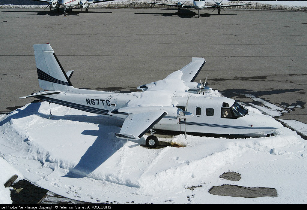
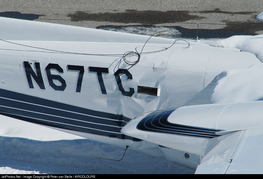
Crash of a Rockwell Grand Commander 690A in Courchevel
Date & Time:
Jan 31, 2005
Registration:
N67TC
Survivors:
Yes
MSN:
690-11233
YOM:
1975
Crew on board:
0
Crew fatalities:
Pax on board:
0
Pax fatalities:
Other fatalities:
Total fatalities:
0
Circumstances:
The twin engine aircraft stalled on approach to Courchevel Airport and touched down hard, causing substantial damage to the fuselage. There were no injuries but the aircraft was damaged beyond repair.

Crash of a Rockwell Grand Commander 690A in Cortez: 1 killed
Date & Time:
Jan 3, 2004 at 1212 LT
Operator:

Registration:
N700SR
Survivors:
No
Schedule:
Mesa – Cortez
MSN:
690-11164
YOM:
1974
Crew on board:
1
Crew fatalities:
Pax on board:
0
Pax fatalities:
Other fatalities:
Total fatalities:
1
Captain / Total hours on type:
91.00
Aircraft flight hours:
7506
Circumstances:
The pilot executed the VOR approach to runway 21. He was heard to report passing the VORTAC outbound for the procedure turn, and crossing the VORTAC (final approach fix) inbound. Witnesses said they saw the airplane emerge from the overcast slightly high and fast. They said the airplane entered a steep left bank and turned about 90 degrees before disappearing in a snow shower northeast of the airport. They heard no unusual engine noises. Another witness near the accident site saw the airplane in a steep bank and at low altitude, "just above the power lines." Based on the witness location, the airplane had turned about 270 degrees. The witness said the wings "wobbled" and the nose "dipped," then the left wing dropped and the airplane descended to the ground "almost vertically." Members of the County Sheriff's Posse, who were at a gunnery range just north of the airport, reported hearing an airplane pass over at low altitude. One posse member said he heard "an engine pitch change." He did not see the airplane because it was "snowing heavily," nor did he hear the impact. An examination of the airplane revealed no anomalies. At the time of the accident, the weather at the destination airport was few clouds 300 feet, 900 feet broken, 3,200 feet overcast; visibility, 1/2 statute and snow; temperature, 32 degrees F.; dew point, 32 degrees F.; wind, 290 degrees at 10 knots, gusting to 15 knots; altimeter, 29.71 inches.
Probable cause:
The pilot's inadequate planned approach and his failure to maintain airspeed which resulted in a stall. Contributing factors were low altitude flight maneuvering in an attempt to lose excessive altitude and realign the airplane for landing, and his failure to perform a missed approach, and the snow fall.
Final Report:
Crash of a Rockwell Grand Commander 690 in Soto la Marina: 1 killed
Date & Time:
Sep 16, 2003 at 1430 LT
Registration:
N302WB
Survivors:
No
Schedule:
Soto La Marina - Laredo
MSN:
690-11003
YOM:
1971
Crew on board:
1
Crew fatalities:
Pax on board:
0
Pax fatalities:
Other fatalities:
Total fatalities:
1
Circumstances:
On September 16, 2003, at 1430 central daylight time, an Aero Commander 690 twin-engine airplane, N302WB was destroyed upon impact with trees and terrain while attempting a takeoff from an airstrip near Soto La Marina, in the State of Tamaulipas, in the Republic of Mexico. The commercial pilot, sole occupant of the airplane, was fatally injured. The airplane was registered to the QEAT-4 LLC., in Naples, Florida, and was being operated by the MGS Corporation of Laredo, Texas. Visual meteorological conditions prevailed for the business flight for which no flight plan was filed. The flight's destination was reported to be Laredo, Texas. Local authorities reported that the turboprop powered airplane, serial number 11003, had previously sustained some damage to the nose landing gear and the owner had replaced the nose landing gear prior to attempting to depart from the airstrip.