Country
code
MT
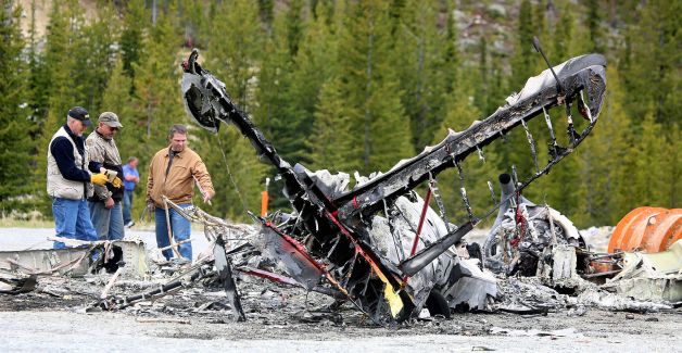
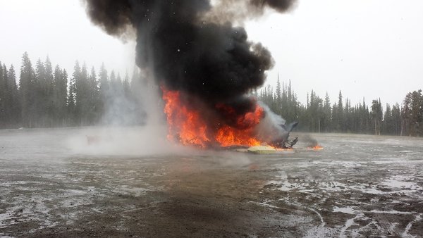
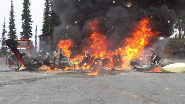
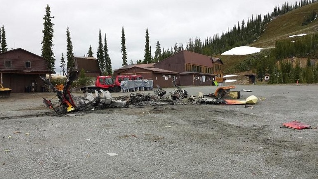
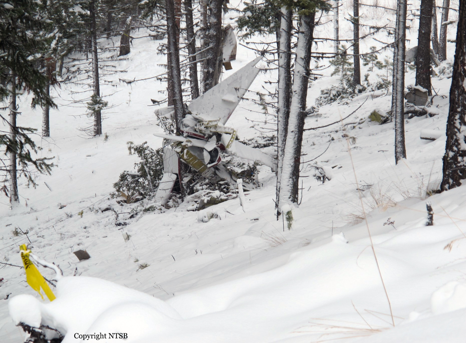
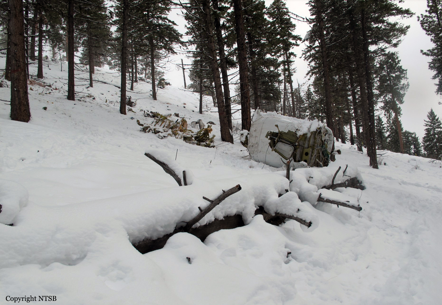
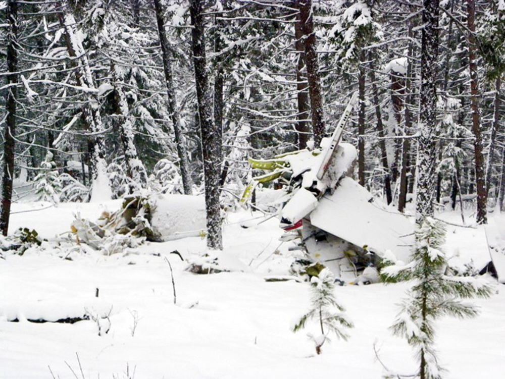
Crash of a Grumman G-21A Goose in Sula: 1 killed
Date & Time:
Jun 17, 2014 at 1700 LT
Registration:
N888GG
Survivors:
No
Schedule:
Salmon - Hamilton
MSN:
B-70
YOM:
1944
Crew on board:
1
Crew fatalities:
Pax on board:
0
Pax fatalities:
Other fatalities:
Total fatalities:
1
Captain / Total hours on type:
50.00
Aircraft flight hours:
6394
Circumstances:
The airline transport pilot was repositioning the airplane to an airport near the owner's summer home. The airplane was not maintained for instrument flight, and the pilot had diverted the day before the accident due to weather. On the day of the accident, the pilot departed for the destination, but returned shortly after due to weather. After waiting for the weather conditions to improve, the pilot departed again that afternoon, and refueled the airplane at an intermediate airport before continuing toward the destination. The route of flight followed a highway that traversed a mountain pass. A witness located along the highway stated that he saw the accident airplane traveling northbound toward the mountain pass, below the overcast cloud layer. He also stated that the mountain pass was obscured, and he could see a thunderstorm developing toward the west, which was moving east toward the pass. A second witness, located near the accident site, saw the airplane descend vertically from the base of the clouds while spinning in a level attitude and impact the ground. The second witness reported that it was snowing and that the visibility was about ¼ mile at the time of the accident. The airplane impacted terrain in a level attitude, and was consumed by a postcrash fire. Examination of the flight controls, airframe, and engine revealed no mechanical malfunctions or anomalies that would have precluded normal operation. It is likely that the pilot experienced spatial disorientation and a subsequent loss of aircraft control upon encountering instrument meteorological conditions. The airplane exceeded its critical angle of attack and entered a flat spin at low altitude, resulting in an uncontrolled descent and impact with terrain.
Probable cause:
The pilot's decision to continue flight into deteriorating weather conditions in an airplane not maintained for instrument flight, which resulted in a loss of control due to spatial
disorientation.
disorientation.
Final Report:

Crash of a Beechcraft B100 King Air in Libby: 2 killed
Date & Time:
Dec 19, 2012 at 0002 LT
Operator:

Registration:
N499SW
Survivors:
No
Schedule:
Coolidge - Libby
MSN:
BE-89
YOM:
1980
Crew on board:
1
Crew fatalities:
Pax on board:
1
Pax fatalities:
Other fatalities:
Total fatalities:
2
Circumstances:
When the flight was about 7 miles from the airport and approaching it from the south in dark night conditions, the noncertificated pilot canceled the instrument flight rules (IFR) flight plan. A police officer who was on patrol in the local area reported that he observed a twin-engine airplane come out of the clouds about 500 ft above ground level and then bank left over the town, which was north of the airport. The airplane then turned left and re-entered the clouds. The officer went to the airport to investigate, but he did not see the airplane. He reported that it was dark, but clear, at the airport and that he could see stars; there was snow on the ground. He also observed that the rotating beacon was illuminated but that the pilot-controlled runway lighting was not. The Federal Aviation Administration issued an alert notice, and the wreckage was located about 7 hours later 2 miles north of the airport. The airplane had collided with several trees on downsloping terrain; the debris path was about 290 ft long. Postaccident examination of the airframe and engine revealed no mechanical malfunctions or failures that would have precluded normal operation. The town and airport were located within a sparsely populated area that had limited lighting conditions, which, along with the clouds and 35 percent moon illumination, would have restricted the pilot’s visual references. These conditions likely led to his being geographically disoriented (lost) and his subsequent failure to maintain sufficient altitude to clear terrain. Although the pilot did not possess a valid pilot’s certificate, a review of his logbooks indicated that he had considerable experience flying the airplane, usually while accompanied by another pilot, and that he had flown in both visual and IFR conditions. A previous student pilot medical certificate indicated that the pilot was color blind and listed limitations for flying at night and for using color signals. The pilot had applied for another student pilot certificate 2 months before the accident, but this certificate was deferred pending a medical review.
Probable cause:
The noncertificated pilot’s failure to maintain clearance from terrain while maneuvering to land in dark night conditions likely due to his geographic disorientation (lost). Contributing to the accident was the pilot’s improper decision to fly at night with a known visual limitation.
Final Report:


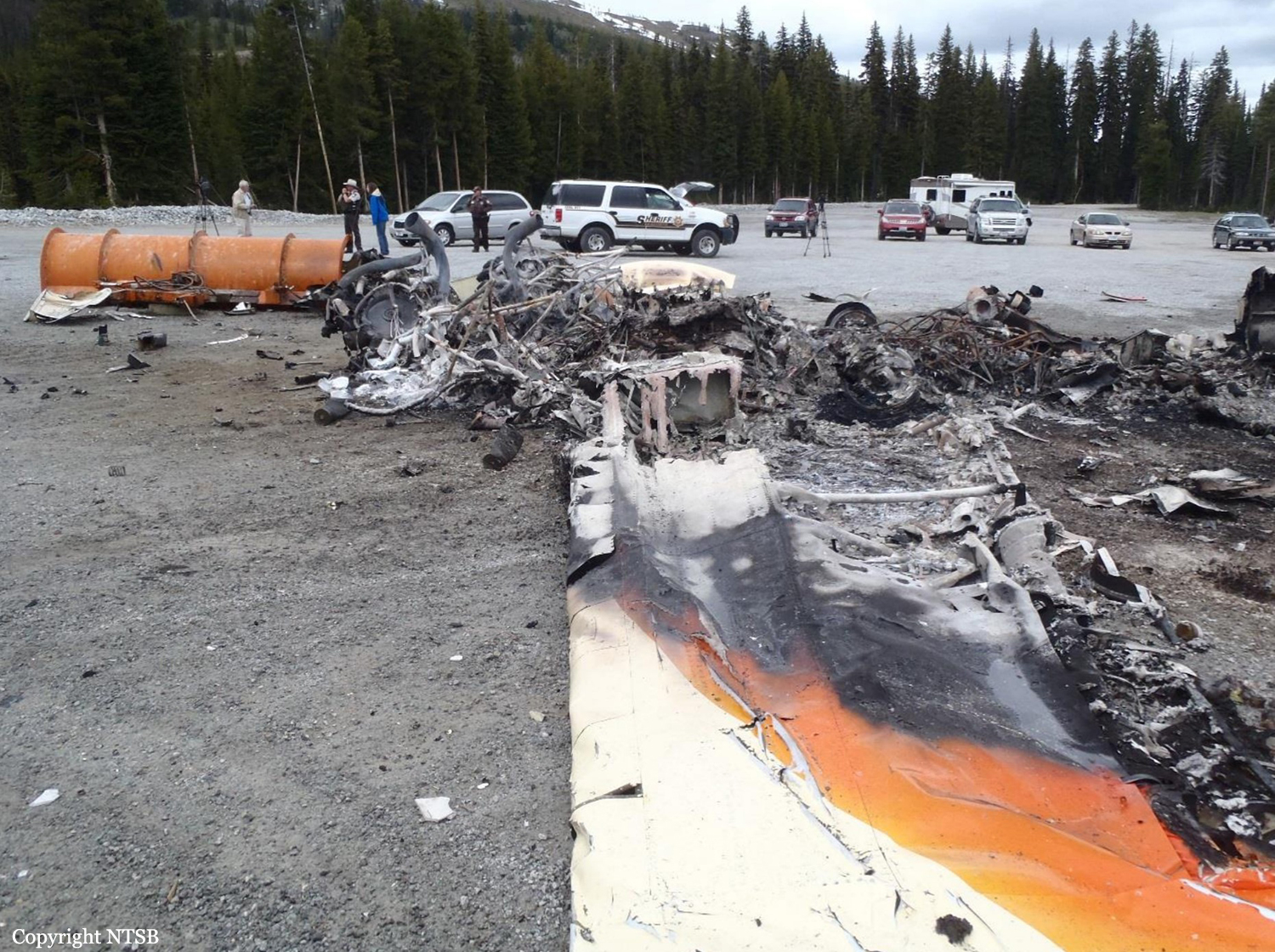
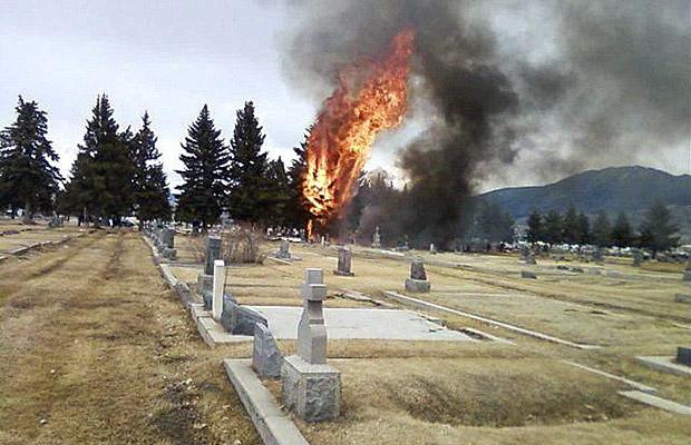
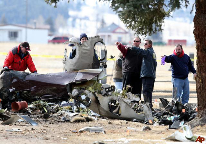
Crash of a Pilatus PC-12/45 in Butte: 14 killed
Date & Time:
Mar 22, 2009 at 1430 LT
Registration:
N128CM
Survivors:
No
Schedule:
Oroville - Bozeman
MSN:
403
YOM:
2001
Crew on board:
1
Crew fatalities:
Pax on board:
13
Pax fatalities:
Other fatalities:
Total fatalities:
14
Captain / Total hours on type:
1760.00
Aircraft flight hours:
1916
Circumstances:
On March 22, 2009, about 1432 mountain daylight time, a Pilatus PC-12/45, N128CM, was diverting to Bert Mooney Airport (BTM), Butte, Montana, when it crashed about 2,100 feet west of runway 33 at BTM. The pilot and the 13 airplane passengers were fatally injured, and the airplane was substantially damaged by impact forces and a post crash fire. The airplane was owned by Eagle Cap Leasing of Enterprise, Oregon, and was operating as a personal flight under the provisions of 14 Code of Federal Regulations Part 91. The flight departed Oroville Municipal Airport, Oroville, California, on an instrument flight rules flight plan with a destination of Gallatin Field, Bozeman, Montana. Visual meteorological conditions prevailed at the time of the accident.
Probable cause:
(1) the pilot’s failure to ensure that a fuel system icing inhibitor was added to the fuel before the flights on the day of the accident;
(2) his failure to take appropriate remedial actions after a low fuel pressure state (resulting from icing within the fuel system) and a lateral fuel imbalance developed, including diverting to a suitable airport before the fuel imbalance became extreme; and
(3) a loss of control while the pilot was maneuvering the left-wing-heavy airplane near the approach end of the runway.
Final Report:

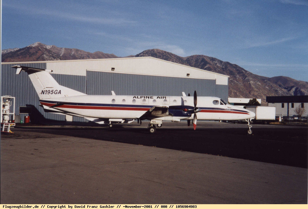
Crash of a Beechcraft 1900C in Billings: 1 killed
Date & Time:
May 23, 2008 at 0124 LT
Operator:

Registration:
N195GA
Survivors:
No
Schedule:
Billings - Great Falls
MSN:
UB-65
YOM:
1986
Flight number:
AIP5008
Crew on board:
1
Crew fatalities:
Pax on board:
0
Pax fatalities:
Other fatalities:
Total fatalities:
1
Captain / Total hours on type:
362.00
Aircraft flight hours:
34651
Circumstances:
About one minute after takeoff on a night Instrument Flight Rules (IFR) contract cargo flight, the tower controller advised the pilot that he was squawking the wrong transponder code. Although the pilot reset the transponder to the correct code, he was advised that he was still squawking the wrong code. He then realized that he had selected the wrong transponder, and then switched to the correct one. During the time the pilot was dealing with this issue, the airplane drifted about 30 degrees right of the assigned heading, but the pilot returned to the correct heading as he was contacting the departure controller. The departure controller cleared him to continue his climb and instructed him to turn left about 120 degrees, which he did. About 40 seconds after initiating his left turn of about 120 degrees, while climbing straight ahead through an altitude about 4,700 feet above ground level (AGL), the pilot was instructed to turn 20 degrees further left. Almost immediately thereafter, the airplane began turning to the right, and then suddenly entered a rapidly descending right turn. The airplane ultimately impacted the terrain in a nearly wings-level nose-down attitude of greater than 45 degrees. At the moment of impact the airplane was on a heading about 220 degrees to the right of the its last stabilized course. The investigation did not find any indication of an airframe, control system, or engine mechanical failure or malfunction that would have precluded normal flight, and no autopsy or toxicological information could be acquired due to the high amount of energy that was released when the airplane impacted the terrain. The determination of the initiating event that led to the uncontrolled descent into the terrain was not able to be determined.
Probable cause:
The pilot's failure to maintain aircraft control during the initial climb for undetermined reasons.
Final Report:
Crash of a Cessna 550 Citation II in Dillon: 2 killed
Date & Time:
May 3, 2007 at 1037 LT
Operator:

Registration:
N22HP
Survivors:
No
Schedule:
Rockford - Dillon
MSN:
550-0103
YOM:
1986
Crew on board:
1
Crew fatalities:
Pax on board:
1
Pax fatalities:
Other fatalities:
Total fatalities:
2
Captain / Total hours on type:
1200.00
Aircraft flight hours:
10526
Circumstances:
Radar data indicated that the airplane descended on a straight track from flight level (FL) 380 in accordance with the pilot's clearance to descend to 13,000 feet and begin the VOR (very high frequency omni-directional radio range) approach to the destination airport. The last transmission from the pilot was an acknowledgment of the cancellation of radar service and an instruction to switch to the airport advisory frequency. At that time, the airplane was at a mode C reported altitude of 14,000 feet. The airplane maintained a steady descent rate for the next minute and leveled off at 13,000 feet. About 2 1/2 minutes later, the airplane began a turn to the right to head outbound for the procedure turn on the approach and descended to 12,900 feet. The approach procedure specified a minimum altitude of 8,200 feet in the procedure turn. The airplane lost 1,600 feet in the next 10 seconds, and this was the last radar contact. A witness working in his office at the airport heard a loud engine noise, and then a “plop” noise. He said that the engine noise was loud, then softer, and then loud again. He heard it for 3 to 5 seconds. Another witness saw an airplane below the cloud bases that was turning to the right with a nose low pitch attitude of about 75 to 80 degrees. It made six to seven turns before it disappeared from sight behind terrain, and the radius of the turn got tighter as the airplane descended. Examination of the airframe, systems, and engines revealed no anomalies that would have precluded normal operation. Anti-ice fluid was on the leading edges of the wing and tail anti-ice panels. An Airmen’s Meteorological Information (AIRMET) in effect for an area that included the accident site noted that the freezing level was from 4,000 to 10,000 feet with the potential for icing from the freezing level to 20,000 feet.
Probable cause:
An in-flight loss of control for undetermined reasons.
Final Report:
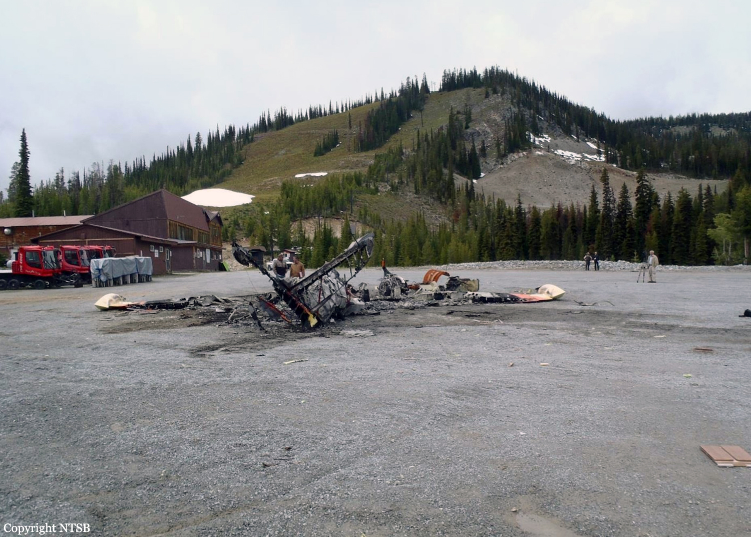
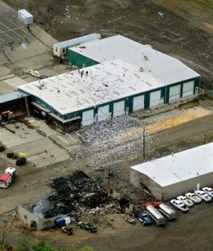
Crash of a Britten-Norman BN-2A-20 Islander in Hamilton
Date & Time:
Apr 28, 2007 at 1105 LT
Operator:

Registration:
N634MA
Survivors:
Yes
Schedule:
Hamilton - Selway Lodge
MSN:
464
YOM:
1975
Crew on board:
1
Crew fatalities:
Pax on board:
0
Pax fatalities:
Other fatalities:
Total fatalities:
0
Captain / Total hours on type:
2750.00
Aircraft flight hours:
16257
Circumstances:
During the initial climb after takeoff, just after the aircraft passed 400 feet above ground level (agl), the pilot shut off the fuel boost pumps in preparation for the en route climb. Soon thereafter, one of the engines lost power without warning, and because he was carrying a heavy load, he immediately feathered the propeller and started looking for a place to put the aircraft down. Because there was rising terrain and scattered houses south of the airport, he had to maneuver to get to an open area. During the forced landing on the uneven terrain, one of the landing gear legs collapsed, and the aircraft impacted the terrain and slid into a power pole. A post-accident teardown inspection of the engine and the aircraft systems did not reveal any anomalies that would have resulted in the failure of the engine that lost power.
Probable cause:
The loss of power in one engine, for undetermined reasons, soon after establishing the takeoff departure climb. Factors include rough/uneven terrain.
Final Report:
Crash of a Beechcraft 200 Super King Air in Bozeman: 3 killed
Date & Time:
Feb 6, 2007 at 2104 LT
Operator:

Registration:
N45MF
Survivors:
No
Schedule:
Great Falls - Bozeman
MSN:
BB-234
YOM:
1977
Crew on board:
1
Crew fatalities:
Pax on board:
2
Pax fatalities:
Other fatalities:
Total fatalities:
3
Captain / Total hours on type:
1318.00
Aircraft flight hours:
5992
Circumstances:
The cross-country flight was on an instrument flight rules (IFR) flight plan, approximately 42 nautical miles from the tower-controlled destination airport, when the pilot was cleared for the visual approach. Dark night visual meteorological conditions prevailed, and there was an overcast layer of clouds at 11,000 feet. After the en route radar service was terminated, the pilot contacted the local control tower and made a garbled and partially unintelligible transmission. Shortly after the time of the transmission, local law enforcement personnel received reports of a downed aircraft. The wreckage was located later that evening approximately 80 feet below the peak of a ridge that rose to an elevation of approximately 5,700 feet. From the initial point of contact with terrain, the debris path was scattered over the crest of the ridge and continued down the opposing side, in a south-southeast direction, toward the airport. The ridge was the highest obstruction between the accident location and the destination airport. The airport is located in a large valley and is surrounded by rising mountainous terrain. At night, clouds and terrain are difficult for pilots to see, and a gradual loss of visual cues can occur as flight is continued toward darker terrain. Additionally, the horizon is less visible and less distinct at night than during the day. Because the pilot was descending the airplane over rural, mountainous terrain that provided few visual ground reference cues, and because the overcast cloud layer would have prevented moonlight from illuminating the terrain, it is likely that the pilot did not see the rising terrain as the airplane continued toward it. The airplane was equipped with an Enhanced Ground Proximity Warning System; however, impact damage to the unit precluded post accident testing. It is not known how the unit was configured during the flight or what type of alerts the pilot received prior to impact. Post accident examination of the wreckage, to include both engines, did not disclose evidence of a mechanical malfunction prior to impact. Additionally, no evidence was found to suggest an in-flight structural failure.
Probable cause:
The pilot's failure to maintain an adequate altitude and descent rate during a night visual approach. Dark night conditions and mountainous terrain are factors in the accident.
Final Report:

Crash of a Pilatus PC-12/47 in Big Timber: 2 killed
Date & Time:
Jun 24, 2006 at 1420 LT
Registration:
N768H
Survivors:
No
Schedule:
Big Timber - Big Timber
MSN:
716
YOM:
2006
Crew on board:
2
Crew fatalities:
Pax on board:
0
Pax fatalities:
Other fatalities:
Total fatalities:
2
Aircraft flight hours:
41
Circumstances:
The private pilot receiving instruction and his flight instructor departed on runway 06 with a headwind of 17 knots gusting to 23 knots. Witnesses said that the pilot had transmitted on Common Traffic Advisor Frequency the intention of practicing a loss of engine power after takeoff, and turning 180 degrees to return to the airport. Another witness said that the airplane pitched up 30 degrees while simultaneously banking hard to the right in an uncoordinated manner. He said that as the airplane rolled to the right, the nose of the airplane yawed down to nearly 45 degrees below the horizon. Subsequently, the airplane's wings rolled level, but the aircraft was still pitched nose down. He said the airplane appeared to be recovering from its dive. A witness said that the airplane appeared to be in a landing flare when he observed dirt and grass flying up behind the aircraft. He said the airplane's right wing tip and engine impacted terrain, and a fire ensued that consumed the airplane. Examination of the accident site revealed that the airplane's right wingtip hit a 10 inch in diameter rock and immediately impacted a wire fence 10 inches above the ground. Approximately 120 feet of triple wire fence continued with the airplane to the point of rest. No preimpact engine or airframe anomalies which might have affected the airplane's performance were identified. The weight and balance was computed for the accident airplane at the time of the accident and the center of gravity was determined to be approximately one inch forward of the forward limit.
Probable cause:
The flight instructor's failure to maintain an adequate airspeed while maneuvering, which led to an inadvertent stall.
Final Report: