Country
code

Special Region of West Papua

Crash of a Cessna 208 Caravan I in Ilaga: 1 killed

Date & Time: Oct 25, 2021 at 0810 LT
Type of aircraft:
Operator:
Registration:
PK-SNN
Flight Type:
Survivors:
Yes
Schedule:
Timika - Ilaga
MSN:
208-0556
YOM:
2014
Country:
Region:
Crew on board:
2
Crew fatalities:
Pax on board:
0
Pax fatalities:
Other fatalities:
Total fatalities:
1
Circumstances:
On final approach to Ilaga Airport, the crew encountered poor visibility due to foggy conditions. The single engine airplane impacted ground near the runway 25 threshold, lost its undercarriage and slid for few dozen metres before coming to rest on the runway. One of the pilot was killed.

Crash of a Boeing 737-33A in Manokwari

Date & Time: May 31, 2017 at 0851 LT
Type of aircraft:
Operator:
Registration:
PK-CJC
Survivors:
Yes
Schedule:
Ujung Pandang – Sorong – Manokwari
MSN:
24025/1556
YOM:
1988
Flight number:
SJY570
Country:
Region:
Crew on board:
6
Crew fatalities:
Pax on board:
146
Pax fatalities:
Other fatalities:
Total fatalities:
0
Captain / Total flying hours:
13371
Captain / Total hours on type:
3110.00
Copilot / Total flying hours:
5570
Copilot / Total hours on type:
2523
Aircraft flight hours:
60996
Circumstances:
On 31 May 2017, a Boeing 737-300 aircraft registration PK-CJC was being operated by PT. Sriwijaya Air as a scheduled passenger flight from Hasanuddin Airport (WAHH), Makassar, South Sulawesi to Rendani Airport (WAUU), Manokwari, West Papua, with one transit stop at Domine Eduard Osok Airport (WASS) Sorong, West Papua. The flight was uneventful since the first departure from Makassar until commencing the approach at Manokwari. At 0815 LT (2315 UTC), the aircraft departed Sorong to Manokwari. On board in the flight were two pilots, four flight attendants and 146 passengers. On this flight, the Second in Command (SIC) acted as Pilot Flying (PF) and the Pilot in Command (PIC) acted as Pilot Monitoring (PM). At 2331 UTC, the pilot made first contact to Rendani Tower controller and informed that the aircraft was descending from FL 230 (altitude 23,000 feet) and requested the weather information. The Rendani Tower controller informed to the pilot that the wind was calm, ground visibility 6 km, cloud FEW CB 1,400 feet, temperature and dew point 26/25°C. At 2336 UTC, Rendani Tower controller instructed to the pilot to descend to 11,000 feet and to report when on Visual Meteorological Condition (VMC). At 2338 UTC, the pilot informed that they were on VMC condition and passed altitude 13,000 feet while position was 32 Nm from ZQ NDB (Non-Directional Beacon). Rendani Tower controller instructed to fly maintain on visual condition, fly via overhead, descend to circuit altitude, join right downwind runway 35, and to report when overhead Manokwari. At 2344 UTC, the pilot reported that the aircraft was over Manokwari and Rendani Tower controller informed to the pilot that the visibility changed to 5 km. Two minutes later Rendani Tower controller instructed to the pilot to continue approach and to report on right base runway 35. At 2349 UTC, at approximately 600 feet, the PIC as PM took over control by called “I have control” and the SIC replied “You have control”. A few seconds later the pilot reported that the aircraft was on final runway 35, and Rendani Tower controller instructed to the pilot to report when the runway 35 insight. The pilot immediately replied that the runway was in sight and acknowledged by Rendani Tower controller who then issued landing clearance with additional information that the wind was calm and the runway condition wet. At approximately 550 feet, the PIC instructed the SIC turn on the wiper and reconfirmed to SIC that the runway was in sight. Between altitude 500 feet to 200 feet, the EGPWS aural warnings “Sink Rate” and “Pull Up” sounded. At 2350 UTC, the aircraft touched down and rolled on runway 35. The spoiler deployed and the pilot activated the thrust reversers. The crew did not feel significant deceleration. The aircraft stopped at approximate 20 meters from the end of runway pavement. After the aircraft stopped, the PIC commanded “Evacuate” through the Passenger Address (PA) system. The Rendani Tower Controller saw that the aircraft was overrun and activated the crash bell then informed the Airport Rescue and Fire Fighting (ARFF) that there was an aircraft overrun after landing on runway 35. All the flight crew and passengers evacuated the aircraft and transported to the terminal building safely.
Probable cause:
According to factual information during the investigation, the Komite Nasional Keselamatan Transportasi identified initial findings as follows:
1. The aircraft was airworthy prior to the accident, there was no report or record of aircraft system abnormality during the flight. The aircraft had a valid Certificate of Airworthiness (C of A) and Certificate of Registration (C of R).
2. The aircraft operator had a valid Air Operator Certificate (AOC) to conduct a scheduled passenger transport.
3. The crew held valid licenses and medical certificates.
4. The weather conditions during aircraft approach and landing was slight rain with cumulonimbus viewed nearby the airport, wind was calm and runway was wet.
5. In this flight Second in Command (SIC) acted as Pilot Flying (PF) and the Pilot in Command (PIC) acted as Pilot Monitoring (PM). The PIC took over control from the SIC during approach at altitude approximately 600 feet.
6. At approximate 550 feet, the PIC instructed the SIC to turn on the wiper and reconfirmed to SIC that the runway was in sight.
7. Between altitude 500 feet to 200 feet, the EGPWS aural warnings “Sink Rate” and “Pull Up” sounded.
8. The CCTV recorded water splash when aircraft on landing roll.
9. Several area of the runway warp in approximate 2 - 5 meters square meters with standing waters on the runway of Rendani Airport.
10. Several runway lights covered by grass with the height approximately of 30-40 cm.
11. Rendani Aerodrome Manual (AM) as general guidelines in the airport operation had not been approved by the DGCA at the time of accident.
12. Rendani Airport (WAUU), Fire fighting category III refer to AIP amended on April 2015.
Final Report:

Crash of a De Havilland DHC-4T Caribou near Ilaga: 4 killed

Date & Time: Oct 31, 2016 at 0830 LT
Type of aircraft:
Registration:
PK-SWW
Flight Phase:
Flight Type:
Survivors:
No
Site:
Schedule:
Timika - Ilaga
MSN:
303
YOM:
1972
Country:
Region:
Crew on board:
4
Crew fatalities:
Pax on board:
0
Pax fatalities:
Other fatalities:
Total fatalities:
4
Captain / Total flying hours:
9336
Captain / Total hours on type:
38.00
Copilot / Total flying hours:
3636
Copilot / Total hours on type:
17
Aircraft flight hours:
2748
Aircraft flight cycles:
5953
Circumstances:
A DHC-4 Caribou aircraft, registered PK-SWW was being operated by Perkumpulan Penerbangan Alfa Indonesia, on 31 October 2016 on an unscheduled cargo flight from Moses Kilangin Airport Timika, with intended destination to Kaminggaru Aerodrome, Ilaga Papua. On board on this flight was 4 persons consisted of two pilots, one company engineer and one flight operation officer. At 2257 UTC, the aircraft departed Timika with intended cruising altitude of 12,500 feet and estimated time of arrival Ilaga at 2327 UTC. At 2323 UTC, the pilot made initial contact with Ilaga Aerodrome Flight Information Services (AFIS) officer and reported that the aircraft position was at Ilaga Pass and informed the estimate time of arrival Ilaga would be on 2327 UTC. Ilaga Aerodrome Flight Information Services (AFIS) officer advised to continue descend to circuit altitude and to report when position on downwind. At 2330 UTC, the AFIS officer called the pilot and was not replied. The AFIS officer asked pilot of another aircraft in the vicinity to contact the pilot of the DHC-4 Caribou aircraft and did not reply. At 0020 UTC, Sentani Aeronautical Information Service (AIS) officer declared the aircraft status as ALERFA. At 0022 UTC, Timika Tower controller received information from a pilot of an aircraft that Emergency Locator Transmitter (ELT) signal was detected approximately at 40 – 45 Nm with radial 060° from TMK VOR (Very High Frequency Omni Range) or approximately at coordinate 4°7’46” S; 137°38’11” E. This position was between Ilaga Pass and Jila Pass. At 0053 UTC, the aircraft declared as DETRESFA. On 1 November 2016, the aircraft wreckage was found on a ridge of mountain between Ilaga Pass and Jila Pass at coordinate 4°5’55.10” S; 137°38’47.60” E with altitude approximately of 13,000 feet. All occupants were fatally injured and the aircraft destroyed by impact force.
Probable cause:
Controlled flight into terrain.
Final Report:

Crash of a Xian MA60 off Kaimana: 25 killed

Date & Time: May 7, 2011 at 1405 LT
Type of aircraft:
Operator:
Registration:
PK-MZK
Survivors:
No
Schedule:
Jayapura - Sorong - Kaimana - Nabire - Biak
MSN:
06 03
YOM:
2008
Flight number:
MZ8968
Country:
Region:
Crew on board:
4
Crew fatalities:
Pax on board:
21
Pax fatalities:
Other fatalities:
Total fatalities:
25
Captain / Total flying hours:
24470
Captain / Total hours on type:
199.00
Copilot / Total flying hours:
370
Copilot / Total hours on type:
234
Aircraft flight hours:
615
Aircraft flight cycles:
764
Circumstances:
On 7 May 2011, an Xi ’An MA60 aircraft, registered PK-MZK was being operated by PT. Merpati Nusantara Airline as a scheduled passenger flight MZ 8968, from Domine Eduard Osok Airport, Sorong, Papua Barat to Utarom Airport (WASK), Kaimana1, Papua Barat. The accident flight was part of series of flight scheduled for the crew. The aircraft departed from Sorong at 0345 UTC2 and with estimated arrival time in Kaimana at 0454 UTC. In this flight, the Second in Command (SIC) was as Pilot Flying (PF) and the Pilot in Command (PIC) as Pilot Monitoring (PM). On board the flight were 2 pilots, 2 flight attendants, 2 engineers and 19 passengers consisting of 16 adults, 1 child and 2 infants. The flight from Sorong was planned under the Instrument Flight Rules (IFR)3. The destination, Kaimana, had no published instrument approach procedure. Terminal area operations, including approach and landing, were required to be conducted under the Visual Flight Rules (VFR). At about 0425 UTC, after passing waypoint JOLAM the crew of MZ 8968 contacted Kaimana Radio and informed that the weather at Kaimana was raining, horizontal visibility of 3 to 8 kilometers, cloud Cumulonimbus broken at 1500 feet, south westerly wind at a speed of 3 knots, and ground temperature 29°C. The last communication with the crew of MZ 8968 occurred at about 0450 UTC. The flight crew asked whether there were any changes in ground visibility and the AFIS officer informed them that the ground visibility remained at 2 kilometer. The visual flight rules requires a visibility of minimum 5 km and cloud base higher than 1500 feet. The evidence indicates that during the final segment of the flight, both crew member were looking outside the aircraft to sight the runway. During this period the flight path of the aircraft varied between 376 to 585 feet and the bank angle increased from 11 to 38 degree to the left. The rate of descent then increased significantly up to about 3000 feet per minute and finally the aircraft impacted into the sea. The accident site was about 800 meters south west of the beginning of runway 01 or 550 meters from the coastline. Most of the wreckage were submerged in the shallow sea between 7 down to 15 meter deep. All 25 occupants were fatally injured. The aircraft was destroyed and submerged into the sea.
Probable cause:
FINDINGS:
1. The aircraft was airworthy prior the accident. There is no evidence that the aircraft had malfunction during the flight.
2. The crew had valid flight license and medical certificate. There was no evidence of crew incapacitation.
3. In this flight the SIC acted as Pilot Flying until the PIC took control of the aircraft at the last part of the flight.
4. According to company operation manual (COM), in a VMC (Visual Meteorological Condition), a “minimum, minimum” EGPWS alert while the approach was not stabilized should be followed by the action of abandoning the approach.
5. The cockpit crew did not conduct any crew approach briefing and checklist reading.
6. As it was recorded in the CVR during the final segment of the flight, both crews member were looking out-side to look for the runway. It might reduce the situational awareness.
7. At the final segment of the flight, the FDR recorded as follows:
• The approach was discontinued started at 376 feet pressure altitude (250 feet radio altitude) and reached the highest altitude of 585 feet pressure altitude. While climbing the aircraft was banking to the left reaching a roll angle of 38 degree. The torque of both engines was increased reaching 70% and 82% for the left and right engine respectively.
• During the go-around, the flaps were retracted to 5 and subsequently to 0 position, and the landing gears were retracted. The aircraft started to descend, and the pitch angle reached 13 degree nose down.
• The rate of descend increased significantly reaching about 3000 feet per minute, and finally the aircraft crashed into the shallow sea.
8. The rapid descent was mainly a result of a combination of situations such as high bank angle (up to 38 deg to the left) and the flaps retracted to 5 and subsequently to 0 position, and also the combination of other situations: engine torque, airspeed, and nose-down pitch.
9. The ERS button was determined in the CRUISE mode instead of TOGA mode. This had led the torque reached 70% and 82% during discontinuing the approach.
10. The flaps were retracted to 5 and subsequently to 0, while the MA-60 standard go-around procedure is to set the flaps at 15.
11. There was limited communications between the crew along the flight. This type of interaction indicated that there was a steep trans-cockpit authority gradient.
12. The SIC was trained in the first three batches which was conducted by the aircraft manufacturer instructor and syllabus, while the PIC was trained by Merpati instructor using modified syllabus. Inadequacy/ineffectivity in the training program may lead to actions that deviated from the standard procedure and regression to the previous type.
13. The investigation found that the Flight Crew Operation Manual (FCOM) and Aircraft Maintenance Manual (AMM) used non-standard English Aviation Language. This finding was supported by a review performed by the Australian Transport Safety Bureau (ATSB).
OTHER FINDINGS:
1. The DFDR does not have the Lateral and Longitudinal acceleration. These two parameters which were non safety related items were mandatory according to the CASR parts 121.343 and 121.344, and at the time of the MA 60 certification, the CCAR 121 did not require those two parameters.
2. Due to impact forces and immersion in water, the Emergency Locator Transmitter (ELT) did not transmit any signal.
FACTORS:
Factors contributed to the accident are as follows:
1. The flight was conducted in VFR in condition that was not suitable for visual approach when the visibility was 2 km. In such a situation a visual approach should not have been attempted.
2. There was no checklist reading and crew briefing.
3. The flight crew had lack of situation awareness when tried to find the runway, and discontinued the approach.
4. The missed approach was initiated at altitude 376 feet pressure altitude (250 feet radio altitude), the pilot open power to 70% and 82% torque followed by flap retracted to 5 and subsequently to 0. The rapid descent was mainly caused by continuously increase of roll angle up to 38 degree to the left and the retraction of flaps from 15 to 0 position.
5. Both crew had low experience/flying time on type.
6. Inadequacy/ineffectivity in the training program may lead to actions that deviated from the standard procedure and regression to the previous type.
Final Report:

Crash of a Boeing 737-322 in Manokwari

Date & Time: Apr 13, 2010 at 1055 LT
Type of aircraft:
Operator:
Registration:
PK-MDE
Survivors:
Yes
Schedule:
Ujung Pandang - Sorong - Manokwari
MSN:
24660/1838
YOM:
1990
Flight number:
MZ836
Country:
Region:
Crew on board:
7
Crew fatalities:
Pax on board:
103
Pax fatalities:
Other fatalities:
Total fatalities:
0
Captain / Total flying hours:
16450
Copilot / Total flying hours:
22139
Aircraft flight hours:
54759
Aircraft flight cycles:
38485
Circumstances:
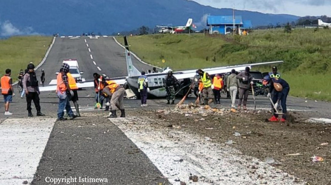
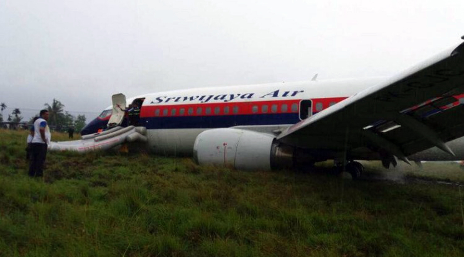
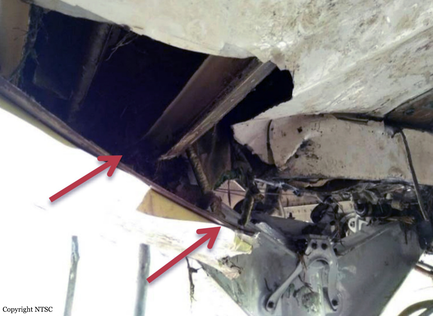
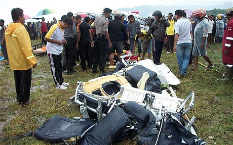
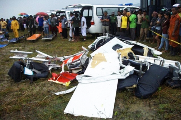
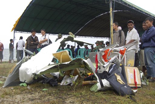
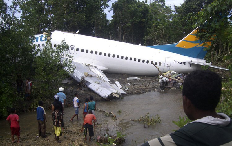
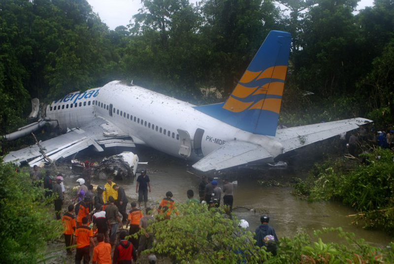
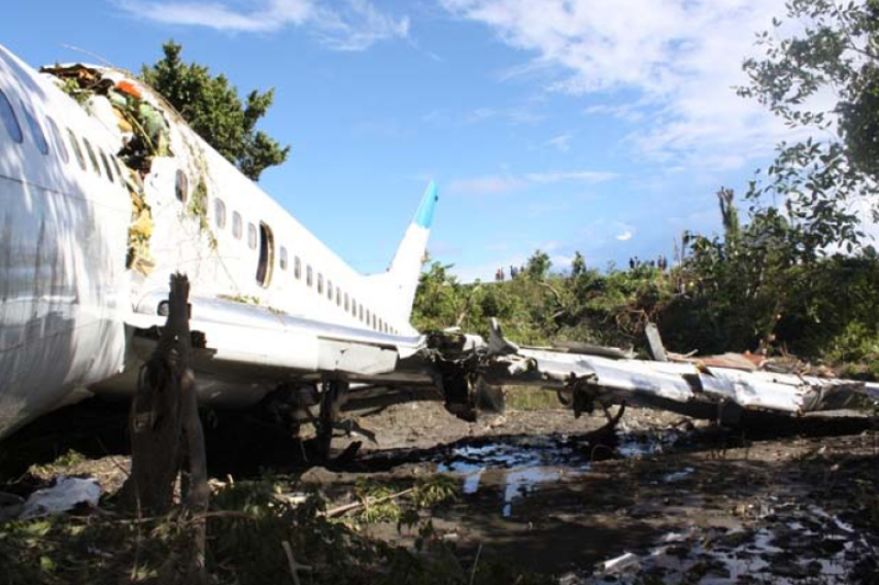
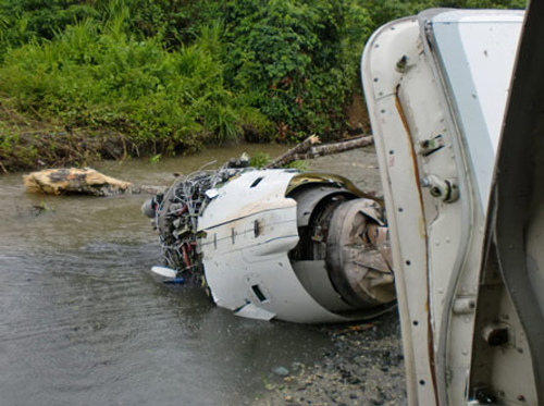
On 13 April 2010, a Boeing B737-300 aircraft registered PK-MDE was being operated by PT. Merpati Nusantara Airline as a scheduled passenger flight MZ 836, from Hasanuddin Airport, Makassar, Sulawesi to Rendani Airport, Manokwari, Papua. It made a transit stop at Domine Eduard Osok Airport, Sorong, Papua. The aircraft departed from Makassar at 2010 UTC and landed at Sorong at 2214 UTC. The scheduled departure time from Sorong was 2235, but due to heavy rain over Manokwari, the departure was delayed for about two hours. The pilot in command was the pilot flying, and the copilot, who also held a command rating on the aircraft, was the support/monitoring pilot. The aircraft subsequently departed Sorong 2 hours and 43 minutes later, at 0118. The observed weather report issued by Badan Meteorologi dan Geofisika (BMG) Manokwari for takeoff and landing at 0100 indicated that the weather was “continuous slight rain, horizontal visibility of 3 to 4 kilometers, cloud overcast cumulus-stratocumulus, westerly wind at 5 knots”. The aircraft’s dispatch release from Sorong indicated that the flight was planned under the Instrument Flight Rules (IFR). The destination, Manokwari, had no published instrument approach procedure. Terminal area operations, including approach and landing, were required to be conducted under the Visual Flight Rules (VFR). At 0146 the crew made the first direct contact with Rendani Radio and reported their position as 14 Nm from Manokwari, and maintaining altitude 10,500 feet. Following this radio contact, Rendani Radio informed the crew that the weather was continuous slight rain, visibility 3 kilometers, cloud overcast with cumulus stratocumulus at 1,400 feet, temperature 24 degrees Celsius, QNH 1012 hectopascals. The transcript of the Rendani Radio communications with the aircraft indicated that controller then instructed the crew to descend and joint right downwind for runway 35, and to report when overhead the airport. Shortly after, the crew reported overhead the airport at 5,000 feet. The controller then instructed the crew to report when they were on final approach for runway 35. The crew acknowledged this instruction. At 0154 the crew reported that they were on final for runway 35. The controller informed them that the wind was calm, runway condition was wet and clear. The crew read back the wind condition and that the runway was clear, but did not mention the wet runway condition. According to the Rendani Airport Administrator’s report to the investigation, the aircraft was observed to make a normal touchdown on the runway at about 0155, about 120 meters from the approach end of runway 35. The report stated that the aircraft’s engine reverser sound was not heard during landing roll. Witnesses on board the aircraft also stated that the aircraft made a smooth landing, and the engine reversers were not heard during the landing roll. During the landing roll, the aircraft veered to the left about 140 meters from the end of runway 35, then overran the departure end of runway 35. At about 0156 it came to a stop 205 meters beyond the end of the runway in a narrow river; the Rendani River. The Observed Weather Report issued by BMG Manokwari for takeoff and landing at 0200 (4 minutes after the accident) indicated that the weather was continuous moderate rain, with a horizontal visibility of 4 kilometers, cloud overcast cumulus stratocumulus, south-westerly wind at 5 knots. The airport rescue and fire fighting unit was immediately deployed to assist the post crash evacuation. Due to the steep terrain 155 meters from the end of runway 35, the rescuers had to turn back and use the airport’s main road to reach the aircraft. The accident site was in an area of shallow muddy water surrounded by mangrove vegetation. The aircraft was substantially damaged. Nearby residents, police and armed forces personnel assisted the evacuation from the aircraft. The Rendani Airport Administrator reported that the passengers and crew members were evacuated and moved from the site by 0230. They were taken to the Manokwari General Hospital, and Manokwari Naval Hospital for further medical treatment.
Final Report:

Crash of a Dornier DO328-100TP in Fakfak

Date & Time: Nov 6, 2008 at 1033 LT
Type of aircraft:
Operator:
Registration:
PK-TXL
Survivors:
Yes
Schedule:
Sorong - Fakfak
MSN:
3037
YOM:
1995
Flight number:
XAR9000
Country:
Region:
Crew on board:
4
Crew fatalities:
Pax on board:
32
Pax fatalities:
Other fatalities:
Total fatalities:
0
Captain / Total flying hours:
10190
Captain / Total hours on type:
2365.00
Copilot / Total flying hours:
4673
Copilot / Total hours on type:
15
Aircraft flight hours:
24404
Aircraft flight cycles:
21916
Circumstances:
The aircraft touched down heavily approximately 5 meters before the touch-down area of runway 10 at Torea Airport, Fak-Fak at 01:33. The investigation found that the left main landing gear touched the ground first (5 meters before the end of the runway), and the right main landing gear touched the ground (4.5 meters from the end of the runway). It stopped on the runway, approximately 700 meters from the touch-down area. The left main landing gear fractured in two places; at the front pivot point, and the aft pivot point. The left fuselage contacted the runway surface 200 meters from the touch-down point and the aircraft slid with the left fuselage on the ground for a further 500 meters, before it stopped at the right edge of the runway. The wing tip and left propeller blade tips also touched the runway and were damaged. The passengers and crew disembarked normally; there were no injuries. Following an inspection of the landing gear and temporary replacement of the damaged left main landing gear, the aircraft was moved to the apron on 8 November 2008 at 04:00. The runway was closed for 5 days.
Probable cause:
The Digital Flight Data Recorder data showed evidence that the aircraft descended suddenly and rapidly when it was on short final approach before the aircraft was above the touchdown area. Propeller RPM was reduced suddenly and rapidly to 70% less than 10 seconds before ground contact. Given that the propellers are constant speed units, the sudden and rapid changes could not be explained other than the probability that a crew member had made the control inputs. The PIC (pilot monitoring/flight instructor) did not monitor the operation of the aircraft sufficiently to ensure timely and effective response to the pilot induced excessive sink rate.
Other Factors:
The airport did not meet the ICAO Annex 14 Standard with respect to the requirement to have runway end safety areas.
Final Report:

Crash of a De Havilland DHC-6 Twin Otter 300 in Ilaga

Date & Time: Aug 6, 1999
Operator:
Registration:
PK-NUU
Flight Type:
Survivors:
Yes
MSN:
478
YOM:
1975
Country:
Region:
Crew on board:
2
Crew fatalities:
Pax on board:
0
Pax fatalities:
Other fatalities:
Total fatalities:
0
Circumstances:
The crew was completing a positioning flight to Ilaga Airport. After touchdown, the twin engine aircraft was unable to stop within the remaining distance. It overran, lost its nose gear and came to rest. Both pilots escaped uninjured and the aircraft was damaged beyond repair.

Crash of a De Havilland DHC-6 Twin Otter 300 in Ilaga

Date & Time: Sep 30, 1996 at 1215 LT
Operator:
Registration:
PK-YPF
Survivors:
Yes
MSN:
210
YOM:
1969
Country:
Region:
Crew on board:
2
Crew fatalities:
Pax on board:
3
Pax fatalities:
Other fatalities:
Total fatalities:
0
Circumstances:
The approach to Ilaga Airport was completed in poor weather conditions due to heavy rain falls. After landing on a wet runway surface, the aircraft was unable to stop within the remaining distance, overran and came to rest down an embankment. All five occupants escaped uninjured while the aircraft was damaged beyond repair.

Crash of an Avro 748-216-2A near Kaimana: 10 killed

Date & Time: Aug 9, 1995
Type of aircraft:
Operator:
Registration:
PK-KHL
Survivors:
No
Site:
Schedule:
Langgur - Kaimana
MSN:
1735
YOM:
1974
Country:
Region:
Crew on board:
6
Crew fatalities:
Pax on board:
4
Pax fatalities:
Other fatalities:
Total fatalities:
10
Circumstances:
While descending to Kaimana Airport, the twin engine aircraft struck the slope of Mt Kumawa (2,800 metres high) located few km from Kaimana. The wreckage was found five days later and all 10 occupants were killed.
Probable cause:
Controlled flight into terrain.

Crash of a De Havilland DHC-6 Twin Otter 300 in Bintuni: 1 killed

Date & Time: Jul 17, 1995
Operator:
Registration:
PK-NUT
Flight Phase:
Survivors:
Yes
Schedule:
Bintuni – Manokwari
MSN:
473
YOM:
1975
Country:
Region:
Crew on board:
2
Crew fatalities:
Pax on board:
16
Pax fatalities:
Other fatalities:
Total fatalities:
1
Circumstances:
During the takeoff roll from runway 13, the twin engine aircraft went out of control, veered off runway and crashed in a banana plantation. One of the pilot was killed while few other occupants were injured, some seriously. The aircraft was written off.
Probable cause:
Loss of control during takeoff after the aircraft suffered aquaplaning