Country
code
Bali
Crash of a Boeing 737-8GP off Denpasar
Date & Time:
Apr 13, 2013 at 1510 LT
Operator:

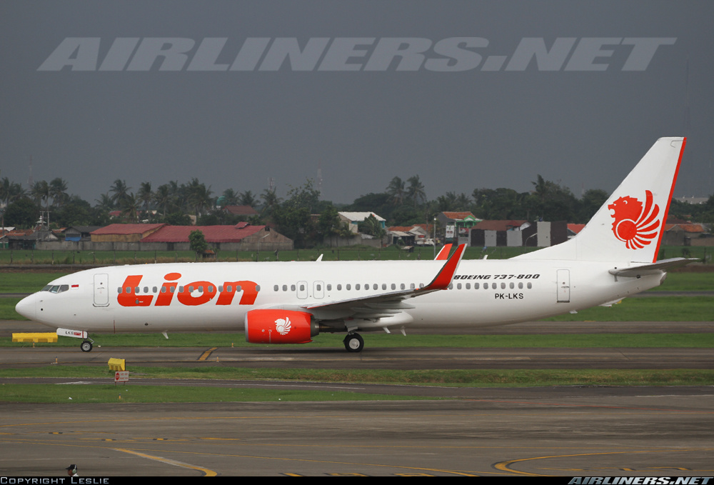
Registration:
PK-LKS
Survivors:
Yes
Schedule:
Bandung - Denpasar
MSN:
38728/4350
YOM:
2013
Flight number:
LNI904
Crew on board:
7
Crew fatalities:
Pax on board:
101
Pax fatalities:
Other fatalities:
Total fatalities:
0
Captain / Total hours on type:
6173.00
Copilot / Total hours on type:
923
Aircraft flight hours:
142
Aircraft flight cycles:
104
Circumstances:
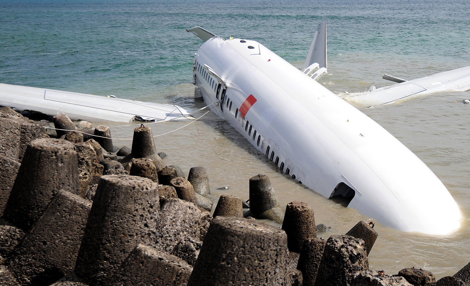
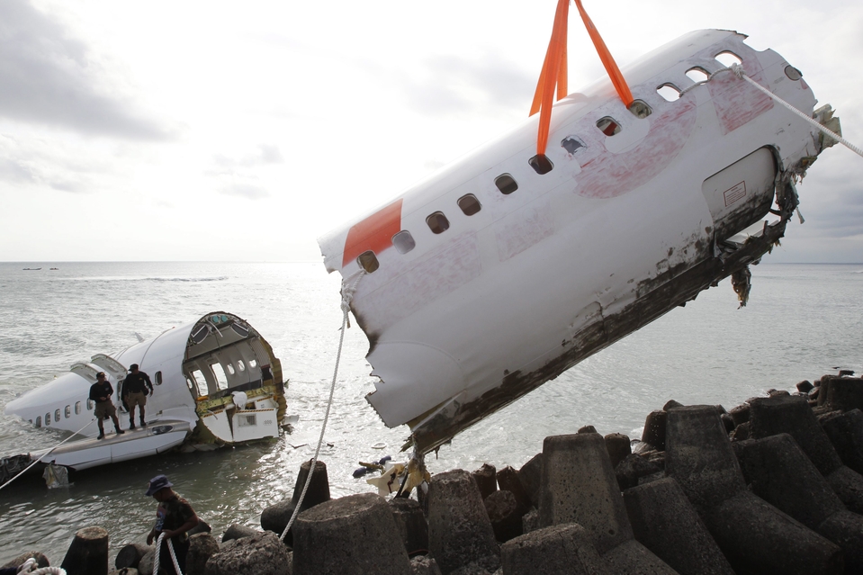
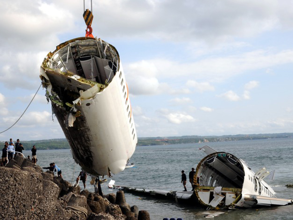
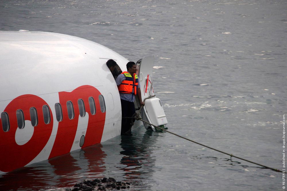
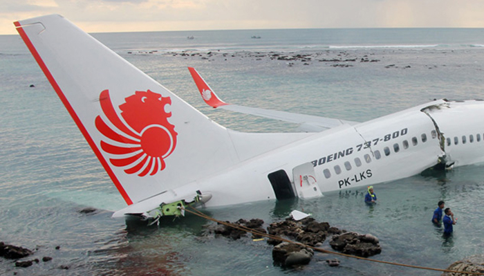
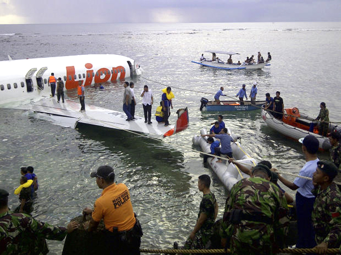
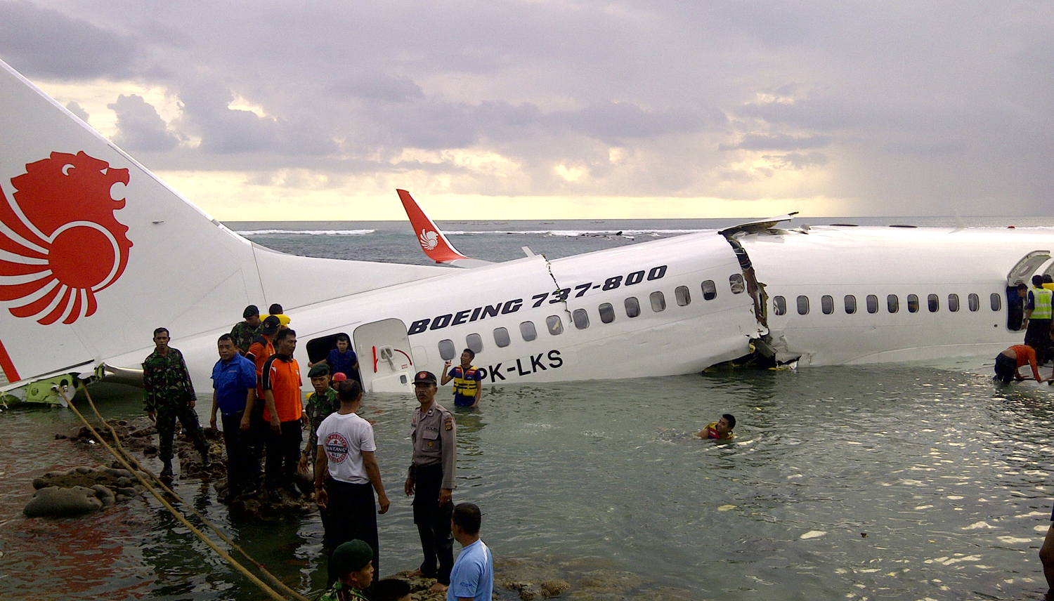
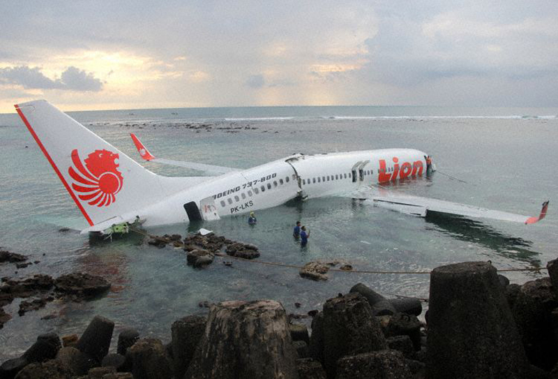
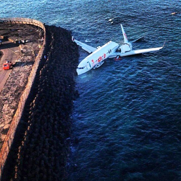
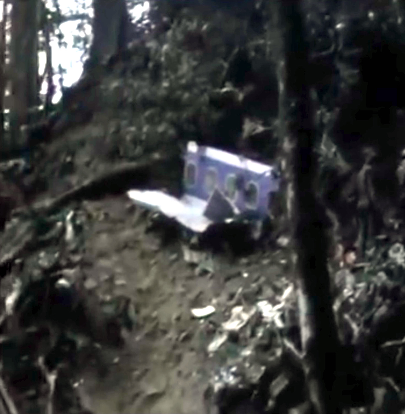
On 13 April 2013, a Boeing 737-800 aircraft, registered PK-LKS, was being operated by PT. Lion Mentari Airlines (Lion Air) on a scheduled passenger flight as LNI 904. The aircraft departed from Husein Sastranegara International Airport (WICC) Bandung at 0545 UTC to Ngurah Rai International Airport (WADD), Bali, Indonesia. The flight was the last sector of four legs scheduled for the crew on that day which were Palu (WAML) - Balikpapan (WALL) - Banjarmasin (WAOO) - Bandung (WICC) - Bali (WADD). The aircraft flew at FL 390, while the Second in Command (SIC) was the Pilot Flying (PF) and the Pilot in Command (PIC) was the Pilot Monitoring (PM). There were 2 pilots, 5 flight attendants and 101 passengers comprising 95 adults, 5 children and 1 infant making a total of 108 persons on board. The flight from the departure until start of the approach into Bali was uneventful. At 0648 UTC, the pilot made first communications with the Bali Approach controller (Bali Director) when the aircraft was located 80 Nm from BLI VOR. The pilot received clearance to proceed direct to the TALOT IFR waypoint and descend to 17,000 feet. At 0652 UTC, the Bali Director issued a further clearance for the pilot direct to KUTA point and descent to 8,000 feet. At 0659 UTC, the aircraft was vectored for a VOR DME approach for runway 09 and descent to 3,000 feet. At 0703 UTC, while the aircraft was over KUTA point, the Bali Director transferred communications with the aircraft to Bali Control Tower (Ngurah Tower). At 0704 UTC, the pilot contacted Ngurah Tower controller and advised that the aircraft was leaving KUTA point. The Ngurah Tower controller instructed the pilot to continue the approach and to reduce the aircraft speed to provide sufficient separation distance with another aircraft. At 0707 UTC, the Ngurah Tower issued take-off clearance for a departing aircraft on runway 09. At 0708 UTC, with LKS at approximately 1,600 feet AGL, the Ngurah Tower controller saw the aircraft on final approach and gave a landing clearance with additional information that the wind was from 120° at 05 knots. At 0708:47 UTC, the aircraft Enhance Ground Proximity Warning System (EGPWS) aural alert called “ONE THOUSAND”, the SIC said one thousand, stabilized, continue, prepare for go-around missed approach three thousand. The FDR showed that the pilot flown using LNAV (Lateral Navigation) and VNAV (Vertical Navigation) during the approach until disengagement of the Auto Pilot. The sequence of events during the final approach is based on the recorded CVR and FDR data, and information from crew interviews as follows: At 0708:56 UTC, while the aircraft altitude was approximately 900 feet AGL, the SIC commented that the runway was not in sight, whereas the PIC commented “OK. Approach light in sight, continue”. At 0709:33 UTC, after the EGPWS aural alert “MINIMUM” sounded at an aircraft altitude of approximately 550 feet AGL, the SIC disengaged the autopilot and the auto-throttle and then continued the approach. At 0709:43 UTC, the EGPWS called “THREE HUNDRED”. At 0709:47 UTC, the CVR recorded a sound similar to rain hitting the windshield. At 0709:49 UTC, the EGPWS called “TWO HUNDRED”. At 0709:53 UTC, while the aircraft altitude was approximately 150 feet AGL, the PIC took over control of the aircraft. The SIC handed control to the PIC and stated that he could not see the runway. At 0710:01 UTC, after the EGPWS called “TWENTY”, the PIC commanded for go-around. At 0710:02 UTC, the aircraft impacted the water, short of the runway. The aircraft stopped facing to the north at about 20 meters from the shore or approximately 300 meters south-west of the beginning of runway 09. Between 0724 UTC to 0745 UTC, three other aircraft took-off and six aircraft landed using runway 09. At 0750 UTC, the airport was closed until 0850 UTC. At 0755 UTC, all occupants were completely evacuated, the injured passengers were taken to the nearest hospitals and uninjured occupants to the airport crisis centre.
Probable cause:
The National Transportation Safety Committee initial findings on the accident flight are as follows:
- The aircraft was airworthy prior to impact and has an item on the DMI (deferred maintenance item) category C (right engine oil filter).
- All crew has valid licenses and medical certificates.
- The Second in Command (SIC) acted as Pilot Flying (PF).
- The flight performed a VOR DME approach runway 09, and the published Minimum Descent Altitude (MDA) was 465 ft AGL.
- The approach configuration used was flap 40.
- At 900 ft AGL the PF did not have the runway in sight.
- Upon reaching the MDA the flight profile indicated a constant path.
- The PIC took over control of the aircraft at about 150 ft radio altitude.
- The SIC handed over control to the PIC at about 150 ft and stated that he could not see the runway.
- The final approach phase of the flight profile was outside the envelope of the EGPWS warning, therefore no EGPWS warning was recorded on the CVR.
The NTSC concluded in its final report that the accident was caused by the following factors:
- The aircraft flight path became unstable below minimum descends altitude (MDA) with the rate of descend exceeding 1000 feet per minute and this situation was recognized by both pilots.
- The flight crew loss of situational awareness in regards of visual references once the aircraft entered a rain cloud during the final approach below minimum descends altitude (MDA).
- The PIC decision and execution to go-around was conducted at an altitude which was insufficient for the go-around to be executed successfully.
- The pilots of accident aircraft was not provided with timely and accurate weather condition despite the weather around the airport and particularly on final approach to the airport was changing rapidly.
Final Report:
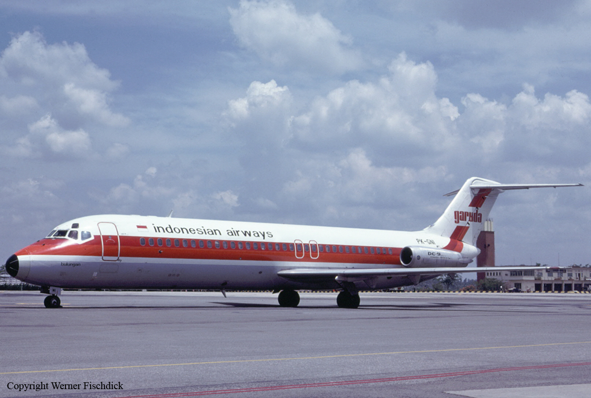
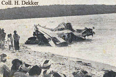
Crash of a Douglas DC-9-32 in Denpasar
Date & Time:
Jun 21, 1993 at 1125 LT
Operator:

Registration:
PK-GNT
Survivors:
Yes
Schedule:
Yogyakarta - Denpasar
MSN:
47790/907
YOM:
1979
Flight number:
GA630
Crew on board:
7
Crew fatalities:
Pax on board:
72
Pax fatalities:
Other fatalities:
Total fatalities:
0
Circumstances:
On approach to Denpasar-I Gusti Ngurah Rai Airport, Bali, the aircraft was too high on the glide. The captain made an overcorrection, causing the aircraft to approach the runway with a high rate of descent. In a nose-up attitude, the aircraft struck the runway surface with a positive acceleration of 5 g. After landing, the crew completed the deceleration and braking procedure, vacated the runway and rolled to the gate where all occupants disembarked safely. A complete inspection of the aircraft by technicians revealed that it suffered major fuselage damages and was later declared as damaged beyond repair.
Probable cause:
Wrong approach configuration on part of the flying crew.
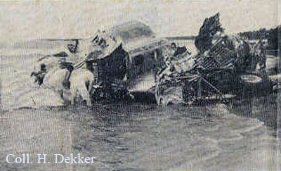
Crash of a Douglas DC-9-32 in Denpasar
Date & Time:
Dec 30, 1984
Operator:
Registration:
PK-GNI
Survivors:
Yes
Schedule:
Jakarta - Denpasar
MSN:
47636
YOM:
1974
Crew on board:
6
Crew fatalities:
Pax on board:
69
Pax fatalities:
Other fatalities:
Total fatalities:
0
Circumstances:
Following several errors during the final approach, the aircraft altitude over the runway 09 threshold was too high. The pilot-in-command decided to continue the landing and the touchdown was completed 1,800 meters past the runway threshold. Unable to stop within the remaining distance, the aircraft overran, lost its undercarriage and came to rest in a mangrove, broken in three. All 75 occupants were evacuated, some of them were injured. The aircraft was destroyed.
Probable cause:
Wrong approach configuration on part of the flying crew.

Crash of a Boeing 707-321C near Denpasar: 107 killed
Date & Time:
Apr 22, 1974 at 2226 LT
Operator:

Registration:
N446PA
Survivors:
No
Schedule:
Hong Kong - Denpasar - Sydney - Suva - Honolulu - Los Angeles
MSN:
19268/544
YOM:
1966
Flight number:
PA812
Crew on board:
11
Crew fatalities:
Pax on board:
96
Pax fatalities:
Other fatalities:
Total fatalities:
107
Captain / Total hours on type:
7192.00
Copilot / Total hours on type:
4776
Aircraft flight hours:
27943
Aircraft flight cycles:
9123
Circumstances:
Following an uneventful flight from Hong Kong-Kai Tak, the crew started the descent to Denpasa-Ngurah Rai Airport by night and limited visibility. While descending to runway 09 at an altitude of 4,000 feet, the airplane initiated a turn to 263° when it struck the slope of Mt Masehe located about 68 km from the airport. The wreckage was found few hours later. The aircraft was totally destroyed upon impact and all 107 occupants have been killed.
Probable cause:
The premature execution of a right-hand turn to join the 263 degrees outbound track which was based on the indication given by only one of the ADF's while the other one was still in steady condition.
Final Report:

Crash of a Consolidated PBY-5A Catalina off Gilimanuk: 1 killed
Date & Time:
Jan 26, 1947
Operator:

Registration:
P-204
Survivors:
Yes
Crew on board:
5
Crew fatalities:
Pax on board:
0
Pax fatalities:
Other fatalities:
Total fatalities:
1
Circumstances:
Crashed into the sea while landing off Gilimanuk, west coast of Bali. A crew member was killed while four others were injured. The seaplane was lost.
Crash of a Consolidated PBY-5 Catalina near Denpasar: 7 killed
Date & Time:
Feb 25, 1942
Operator:

Registration:
44
Survivors:
No
Crew on board:
7
Crew fatalities:
Pax on board:
0
Pax fatalities:
Other fatalities:
Total fatalities:
7
Circumstances:
The floatplane was engaged in an operation over the Bali Island. While approaching Denpasar Airport at an altitude of 150 feet, it was shot down by a Japanese fighter and crashed, bursting into flames. All seven crew members were killed.
Crew:
Ltjg William S. Robinson, pilot,
RM1c Ted Moreland,
AMM1c Alder J. Holder,
AMM2c Dodd W. Watkins,
RM1c Paul H. Landers,
AM2c Willard O. Perry,
RM2c Truman W. Miller.
Crew:
Ltjg William S. Robinson, pilot,
RM1c Ted Moreland,
AMM1c Alder J. Holder,
AMM2c Dodd W. Watkins,
RM1c Paul H. Landers,
AM2c Willard O. Perry,
RM2c Truman W. Miller.
Probable cause:
Shot down by a Japanese fighter.
Crash of a Lockheed 14-WF62 Super Electra off Denpasar: 8 killed
Date & Time:
Jan 22, 1940
Operator:

Registration:
PK-AFO
Survivors:
Yes
Schedule:
Batavia – Denpasar – Kupang – Darwin – Sydney
MSN:
1415
YOM:
1938
Crew on board:
4
Crew fatalities:
Pax on board:
5
Pax fatalities:
Other fatalities:
Total fatalities:
8
Circumstances:
Shortly after take off from Denpasar Airport, while climbing to a height of some 100 metres, the captain initiated a turn to the left when he lost control of the aircraft that plunged into the sea, close to the beach. While the engineer was seriously injured, all eight other occupants were killed. The aircraft was completely wrecked while hitting the water surface.
Crew:
J. J. Schott, pilot, †
D. H. Janzee, copilot, †
Mr. Van't Riet, engineer,
Mr. Van Ende, radio operator. †
Passengers:
Mr. Harper, †
Mr. Johnston, †
Mr. Kanji, †
Mr. Learayd, †
Mr. Mijnlief. †
Crew:
J. J. Schott, pilot, †
D. H. Janzee, copilot, †
Mr. Van't Riet, engineer,
Mr. Van Ende, radio operator. †
Passengers:
Mr. Harper, †
Mr. Johnston, †
Mr. Kanji, †
Mr. Learayd, †
Mr. Mijnlief. †
Crash of a Fokker F7b/3m near Tabanan
Date & Time:
Aug 16, 1932 at 1215 LT
Operator:
Registration:
PK-AFE
Survivors:
Yes
Schedule:
Surabaya – Grogak – Tabanan – Kupang
MSN:
5123
YOM:
1929
Crew on board:
3
Crew fatalities:
Pax on board:
1
Pax fatalities:
Other fatalities:
Total fatalities:
0
Circumstances:
The crew and the passenger were prospecting new routes to Kupang, Sunda Island, and were also distributing flyers to locals. While approaching Tabanan at an altitude of 1,250 metres, the pilot noted the presence of a ridge in front of him. Due to the topography of the terrain, it was not possible for him to make a U turn. He increased engine power but the airplane was unable to gain height so it impacted trees, stalled and crashed in a wooded area. All four occupants were rescued and the pilot was slightly injured.