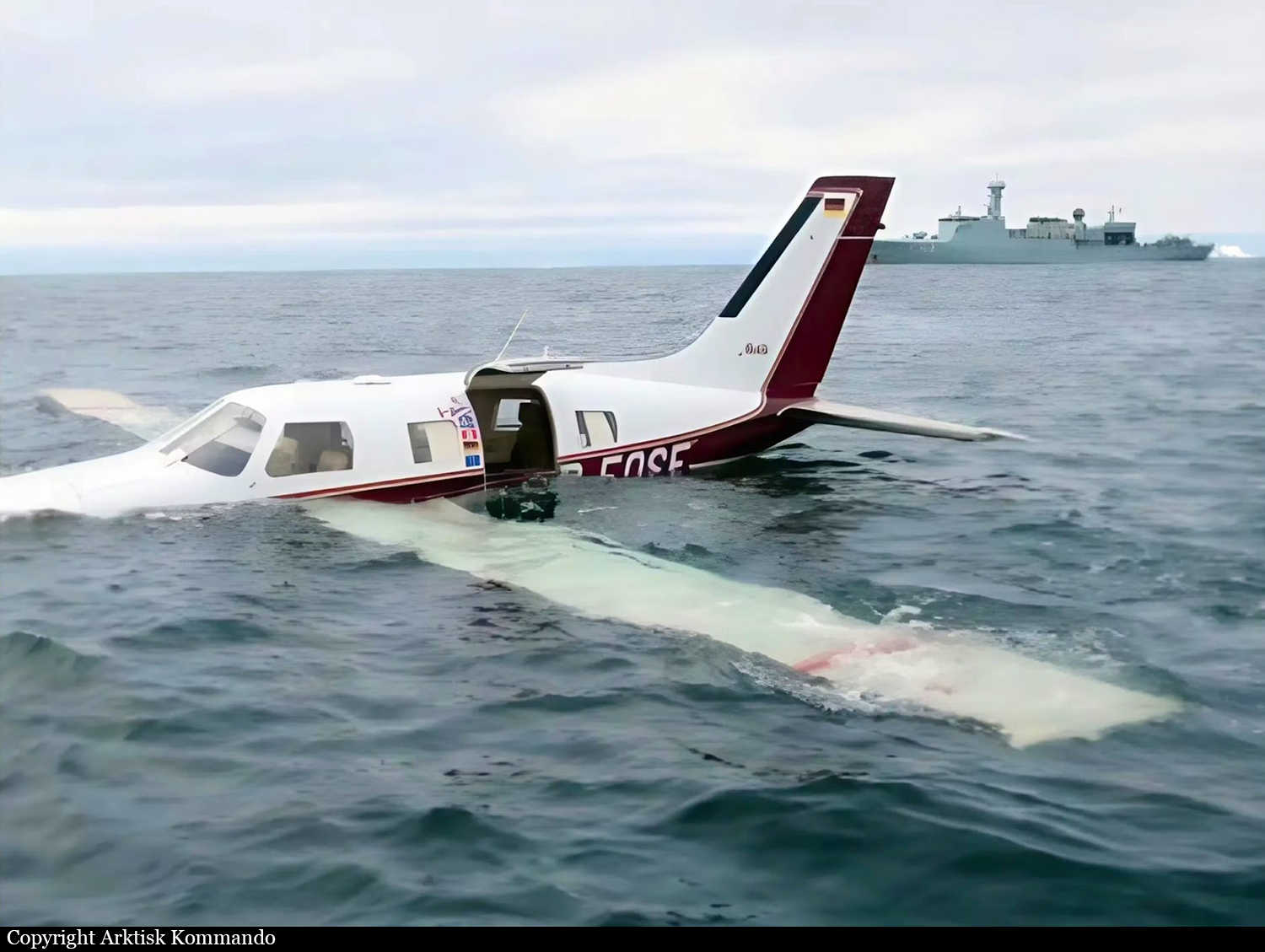
Crash of a Piper PA-46-310P Malibu off Qaqortoq

Date & Time: Jul 29, 2024 at 1333 LT
Operator:
Registration:
D-EOSE
Flight Phase:
Flight Type:
Survivors:
Yes
Schedule:
Goose Bay – Narsarsuaq
MSN:
46-08010
YOM:
1986
Country:
Region:
Crew on board:
1
Crew fatalities:
Pax on board:
1
Pax fatalities:
Other fatalities:
Total fatalities:
0
Captain / Total flying hours:
17802
Captain / Total hours on type:
107.00
Aircraft flight hours:
3590
Circumstances:
The crew was returning to Europe after taking part to the AirVenture airshow in Oshkosh. Following a fuel stop in Goose Bay, the crew continued to Narsarsuaq, Greenland. The initial cruise level was FL210, but after a short while, ATC instructed the pilot to descend to FL180. The pilot set the cruise power to 65% (26.5' Manifold Pressure (MP) and 2,400 revolutions per minute (rpm)), and the Fuel Flow (FF) leaned to 14 US gallons per hour (gph) with a Turbine Inlet Temperature (TIT) of 50° Fahrenheit (F) Lean of Peak (LOP). The weather en route was 'nice' and mostly VMC, and the Outside Air Temperature (OAT) at FL180 was approximately -10° to -15° Celsius (C). The pilot contacted Nuuk Information (ATS unit Flight Information Center (FIC) Nuuk) when the aircraft entered Nuuk Flight Information Region (FIR). At 1304LT, in preparation for landing in BGBW, the pilot reported a descent from FL180 to 11,000 feet inbound to the IFR reporting point SIMNI (located at the Greenlandic coastline, 45 nm south-west of BGBW). The pilot initiated a 500 feet per minute descent and kept the cruise power setting at 65%. While passing FL160, the pilot and the passenger briefly noticed an 'unusual, electrical, and not very strong smell'. The cabin altitude started increasing by a rate of 3,000 fpm, and the pilot realized 'something was wrong'. Shortly after, the CABIN ALTITUDE annunciator warning light illuminated, indicating a cabin altitude above 10,000 feet. As the aircraft was below an altitude of 15,000 feet and descending, the pilot considered the time of useful consciousness and opted not to don the oxygen masks. At 1316LT, the pilot declared an urgency situation to Nuuk Information: 'Pan-Pan, Pan-Pan, Pan-Pan. We have an air conditioning problem and a low oil pressure indication'. The MP dropped from 26” to 17-18” and the pilot moved the throttle lever forward without any effect. All Cylinder Head Temperatures (CHT) indicated 'normal and balanced', and the pilot moved the mixture control full forward to the rich position. The engine almost stopped, and the pilot retarded the mixture control back to the previous position. The aircraft pitch was adjusted to obtain the best glide airspeed of 90 knots. At 1317LT, while descending through 12,000 feet, the pilot declared a distress situation to Nuuk Information: 'Mayday, Mayday, Mayday. We have high rpm now and will try to make it to the shore'. The pilot activated the aircraft Emergency Locator Transmitter (ELT). A surveillance aircraft from the RDAF and an inspection ship from the RDN were on patrol in the area. The Danish Armed Forces Arctic Command allocated both to provide assistance. While descending through 7,000 feet altitude, the propeller rpm increased to 3,000 rpm, and 30 seconds later, the oil pressure indicated zero. The pilot pulled back the mixture handle to the idle/cut-off position and stopped the engine to avoid major mechanical damage. The pilot observed on his knee-mounted tablet that the predicted gliding distance of the aircraft fell short of the coastline. At 1326LT, the pilot informed Nuuk Information of the expected ditching position: 60° 30' N 46° 45' W. The pilot and the passenger prepared to ditch by checking the location of the life raft in the cabin, zipping up their survival suits (which they were already wearing up to their waists), and tightening their seat belts. At 1329LT, as the aircraft was passing 3,300 feet descending, the RDAF surveillance aircraft spotted the aircraft gliding on a north-easterly course over a low overcast. At approximately 1,700 feet, the aircraft entered the cloud layer, and exited below at approximately 700 feet. The RDAF surveillance aircraft lost sight of the aircraft as it entered the cloud layer. In order to safely descend below the cloud layer in VMC, the flight crew of the RDAF surveillance aircraft had to fly to the coastline, descend, and fly back towards the expected ditching position below the cloud layer. The visibility below the cloud layer was 'good', and the sea surface had 'only low swells'. At 1333LT, the pilot selected flap setting 2 (20°), slowed down the aircraft to minimum airspeed, and flared the aircraft straight ahead. The aircraft bounced slightly on the sea surface once, before hitting the sea surface a second time. The aircraft decelerated fairly abruptly – 'similar to a hard brake in a car' – and stopped in a wings-level position, floating on the surface. The pilot and the passenger released their seat belts, went into the aft cabin, and opened the top part of the aircraft entrance door, which was above the water level. They manoeuvred the life raft through the entrance door into the water and inflated the raft. The pilot and the passenger threw a few personal items into the raft and stepped directly from the aircraft into the raft. At 1340LT, at position 60° 34' N 46° 50' W, the RDAF surveillance crew spotted the life raft with the pilot and passenger. For the next 45 minutes, the RDAF surveillance aircraft circled overhead the life raft. At approximately 1400LT, the pilot contacted Nuuk FIC via satellite telephone. At 1423LT, a rescue crew in a rigid-hulled inflatable boat (RHIB) dispatched from the RDN inspection ship and picked up the pilot and passenger. The aircraft sank approximately 2 hours after the ditching.
Probable cause:
An engine failure during descent resulted in a ditching off the southwest coast of Greenland. The AIB could not determine the exact cause of the engine failure, but it was likely due to a seeping oil leak.
A combination of the following factors made the accident survivable:
- The pilot declared an urgency followed by an emergency to ATS, and a nearby RDAF surveillance aircraft obtained visual contact with the gliding aircraft.
- The pilot successfully landed the aircraft on calm sea.
- The pilot and the passenger wore survival suits and carried a life raft on board, which they boarded upon safely evacuating the aircraft.
- After 50 minutes, personnel from a nearby RDN inspection ship arrived and rescued the pilot and passenger.
Final Report:

Crash of a Cessna 402B off Easton: 1 killed

Date & Time: Jul 16, 2024 at 0932 LT
Type of aircraft:
Registration:
N7875E
Flight Type:
Survivors:
No
Schedule:
Fort Meade - Easton
MSN:
402B-0432
YOM:
1973
Crew on board:
1
Crew fatalities:
Pax on board:
0
Pax fatalities:
Other fatalities:
Total fatalities:
1
Circumstances:
On approach to Easton-Newman Field Airport Runway 04, MD, the pilot lost control of the airplane that crashed into the Tred Avon River. The wreckage was found about 7 km short of runway. The airplane sank and the pilot was killed. The pilot apparently reported engine problem on final.

Crash of a De Havilland DHC-2 Beaver near Red Lake: 1 killed

Date & Time: Jun 16, 2024 at 0655 LT
Type of aircraft:
Operator:
Registration:
C-GBZH
Flight Phase:
Survivors:
Yes
Schedule:
Chukuni River - Thicketwood Lake
MSN:
1518
YOM:
1963
Country:
Crew on board:
1
Crew fatalities:
Pax on board:
4
Pax fatalities:
Other fatalities:
Total fatalities:
1
Captain / Total flying hours:
1773
Captain / Total hours on type:
816.00
Aircraft flight hours:
13590
Circumstances:
The float-equipped aircraft operated by Canadian Fly-in Fishing was preparing to depart from the Chukuni River, approximately 2.2 nautical miles (NM) southeast of the Red Lake (Howey Bay) Water Aerodrome (CKS4), on a visual flight rules flight to Thicketwood Lake. At approximately 0653LT the aircraft departed with the pilot, 4 passengers, and cargo on board. Winds were observed by the pilot to be from the south. A normal takeoff was conducted with the flaps in the TAKEOFF setting, and with the heading approximately 120° magnetic. The aircraft accelerated and lifted off as planned about halfway down the waterway (approximately 2,500 feet downriver). As the aircraft gained airspeed to 80 mph, the pilot initiated a climb. Once the climb was established at approximately 100 feet above water, the pilot reduced the engine power to 30 inches of manifold pressure at 2,000 rpm. Along with this power change, the wing flaps were raised from the TAKEOFF position to the CLIMB position. Shortly thereafter, the pilot noticed the aircraft descending, accompanied by a decrease in airspeed to 60 mph. The pilot pushed forward on the control wheel and simultaneously added full power in an attempt to regain airspeed. The aircraft’s airspeed did not increase, and the pilot made a turn to the right, into the wind. At a height of approximately 80 feet above the water, the aircraft entered an aerodynamic stall, with a roll to the right. Aircraft control was lost and, at 0655LT, the aircraft collided with the shoreline in a nose-down, banked attitude. The aircraft was substantially damaged. There was no post-impact fire. The emergency locator transmitter activated. The aircraft occupants were all partially submerged in water when the aircraft came to rest. The pilot egressed through the right-side door and assisted the front-seat passenger out of the aircraft while the other 3 passengers were assisted from the aircraft by local residents. Two of the passengers, who had been seated in the left and right back seats, were seriously injured and were airlifted to hospital in Thunder Bay. One of these passengers subsequently died while in hospital. The pilot and the 2 other passengers were medically evaluated at a local hospital and released.
Probable cause:
Based on the aircraft’s configuration and the most accurate weight information available to the investigation, it was determined that, at the time of takeoff, the estimated weight of the aircraft was 334 pounds over the maximum gross take-off weight of 5,090 pounds, but within the correct centre of gravity range. The operator’s take-off weight calculation prior to the flight was 5,359 pounds as the passenger weights were averaged from a group weigh-in as per the company operations manual approved by TC. The eight passengers weighed a total of 1,812 pounds. The group was then split between two aircraft, four passengers in each. One of the passengers weighed significantly more than the average for the group and was positioned in the occurrence aircraft, resulting in a gross weight increase that was not accounted for.
Final Report:

Crash of a Beechcraft B200 Super King Air into Lake Maracaibo: 8 killed

Date & Time: May 9, 2024 at 1548 LT
Operator:
Registration:
YV3296
Flight Phase:
Flight Type:
Survivors:
No
Schedule:
Maracaibo - Porlamar
MSN:
BB-885
YOM:
1981
Country:
Crew on board:
2
Crew fatalities:
Pax on board:
6
Pax fatalities:
Other fatalities:
Total fatalities:
8
Circumstances:
About 12 minutes after takeoff from Maracaibo-La Chinita Airport, while flying at an altitude of 10,000 feet, the twin engine airplane entered an uncontrolled descent and crashed into Lake Maracaibo. The airplane disintegrated on impact and all 8 occupants were killed. The flight was en route to Porlamar-Del Caribe-General en Jefe Santiago Mariño Airport when the accident occurred.

Crash of a Cessna 340A in Puerto Cabello: 2 killed

Date & Time: Apr 26, 2024 at 1800 LT
Type of aircraft:
Registration:
YV3112
Flight Type:
Survivors:
Yes
Schedule:
Los Roques - Puerto Cabello
MSN:
340A-0794
YOM:
1979
Country:
Crew on board:
1
Crew fatalities:
Pax on board:
4
Pax fatalities:
Other fatalities:
Total fatalities:
2
Captain / Total flying hours:
12000
Aircraft flight hours:
4272
Circumstances:
The airplane departed Los Roques on a flight to Valencia, carrying four passengers and one pilot. After takeoff, the pilot requested ATC for a change in the itinerary with Puerto Cabello-Bartolomé Salom Airport as new destination. Approaching the airport from the north, both engines failed simultaneously. The airplane lost height and crashed in the lagoon of La Salina. The wreckage was found one km north from runway 11 threshold. The airplane was destroyed, the pilot and one passenger were killed and three other occupants were injured.
Probable cause:
Failure of both engines on approach due to a fuel exhaustion.
The following contributing factors were identified:
- Inadequate preflight planning, which caused a discrepancy between the estimated fuel consumption and the actual consumption during the flight path.
- The pilot conducted several flights without proper verification of the availability of fuel required for the planned route.
- According to the instrument's indication, both engines were connected to the right fuel tank.
- Based on the information provided by the instruments, it was determined that the airplane was not prepared for landing at the time of the incident.
Final Report:

Crash of a Britten-Norman BN-2A-21 Islander off San Cristóbal Island

Date & Time: Feb 12, 2024 at 0900 LT
Type of aircraft:
Operator:
Registration:
HC-CXK
Flight Phase:
Survivors:
Yes
Schedule:
San Cristóbal - Puerto Villamil
Country:
Crew on board:
2
Crew fatalities:
Pax on board:
7
Pax fatalities:
Other fatalities:
Total fatalities:
0
Circumstances:
The twin engine airplane crashed into the sea some 1,5 km off the beach of Punta Carola, San Cristóbal Island, Galapagos. The airplane sank while all nine occupants were rescued. It appears that the airplane was en route to Puerto Villamil Airport, Isabela Island, when the accident occurred.

Crash of a Beriev A-50U off Kyrylivka: 11 killed

Date & Time: Jan 14, 2024 at 2112 LT
Type of aircraft:
Operator:
Registration:
RF-93966
Flight Phase:
Survivors:
No
MSN:
00834 76298
YOM:
1988
Country:
Region:
Crew on board:
11
Crew fatalities:
Pax on board:
0
Pax fatalities:
Other fatalities:
Total fatalities:
11
Captain / Total flying hours:
0
Circumstances:
Coded 37 Red and operated by the Russian Aerospace Forces (VKS-Vozdushno-kosmicheskiye sily Rossii), the airplane was engaged in a survey mission of the south Crimea area when it was apparently shot down by Ukrainian Forces and crashed into the Azov Sea off the city of Kyrylivka. It is believed that all 11 crew members have been killed.

Crash of a Gulfstream GIII off Canouan: 4 killed

Date & Time: Dec 22, 2023 at 1435 LT
Type of aircraft:
Registration:
N337LR
Flight Phase:
Flight Type:
Survivors:
No
Schedule:
Canouan - Canouan
MSN:
337
YOM:
1981
Crew on board:
1
Crew fatalities:
Pax on board:
3
Pax fatalities:
Other fatalities:
Total fatalities:
4
Circumstances:
The airplane departed Canouan Airport at 1427LT on a local flight, carrying apparently three passengers and one pilot. About six minutes after takeoff, the airplane disappeared from radar screens and crashed into the sea two minutes later, at 1435LT. It is unclear if the wreckage was found. The airplane's operations were apparently monitored by the Drug Enforcement Administration (DEA) for some time and it is believed that the pilot may have switched off the transponder after takeoff. Illegal operation suspected.

Crash of a Cessna 421C Golden Eagle III off Sunshine Coast

Date & Time: Nov 10, 2023 at 0907 LT
Operator:
Registration:
VH-VPY
Flight Phase:
Flight Type:
Survivors:
Yes
Schedule:
Sunshine Coast - Pago Pago
MSN:
421C-0688
YOM:
1979
Country:
Region:
Crew on board:
2
Crew fatalities:
Pax on board:
0
Pax fatalities:
Other fatalities:
Total fatalities:
0
Captain / Total flying hours:
4000
Copilot / Total flying hours:
1400
Copilot / Total hours on type:
100
Circumstances:
On the morning of 10 November 2023, a Cessna 421C, registered VH-VPY, departed the Sunshine Coast Airport, Queensland for a transpacific international ferry flight to Oakland, California in the United States. Two pilots were on board to conduct the flight, where the first leg was planned to stop at Pago Pago, American Samoa. The aircraft was configured with additional ferry fuel tanks to ensure sufficient fuel was available between the stops for the extended journey across the open ocean. Approximately 50 minutes after departure, the left engine failed and the pilots initiated a return to the Sunshine Coast. During the return leg the pilots identified that the aircraft was unable to maintain altitude and calculations based on the descent rate indicated they would be unable to reach the Sunshine Coast. The pilots notified air traffic control of their intention to ditch, who immediately engaged the national search and rescue service provider. After considering the configuration of the aircraft, the pilots elected not to follow the aircraft manufacturer’s guidance on ditching. They configured the aircraft to avoid a nose down attitude on touchdown and allowed their airspeed to slow before the aircraft contacted the water. Both occupants were uninjured and exited through the rear door. After deploying the emergency life raft, both pilots were retrieved by a rescue helicopter 32 minutes after ditching. The aircraft sank and was not recovered.
Probable cause:
Contributing factors:
- While flying over open water the left engine failed. The nature of the engine failure prevented the propeller from feathering and the excess drag from the windmilling propeller reduced the available performance of the aircraft.
- Following the engine failure, as it was not possible for the pilot to quickly jettison sufficient fuel from the ferry tank, the weight of that fuel further reduced aircraft performance, resulting in the aircraft ditching.
Other factor that increased risk:
- The aircraft was loaded in excess of the weight and balance limitations imposed by the special ferry flight permit, and in addition, an unapproved modification was made to the ferry fuel system. These actions removed the defences incorporated into the ferry permit approval process and increased the likelihood of an adverse outcome.
- Both pilots did not hold the appropriate approvals and ratings to conduct the ferry flight.
Other findings:
- The pilots were familiar with the survival equipment and were well prepared in the event of a ditching.
- While the pilot actions during the ditching were not consistent with the flight manual, the method utilized considered the aircraft configuration and its performance in the prevailing conditions. It could not be determined if this increased the likelihood of aircraft damage/breakup when compared to the manufacturer's procedure.
- Early communication between the pilots, air traffic control and the Australian Maritime Safety Authority’s Response Centre allowed rescue efforts to commence prior to ditching, increasing the chances of survival.
Final Report:

Crash of a Cessna 402B off Bimini: 1 killed

Date & Time: Aug 19, 2023 at 1258 LT
Type of aircraft:
Operator:
Registration:
C6-SPK
Flight Phase:
Flight Type:
Survivors:
No
Schedule:
Fort Lauderdale – North Eleuthera
MSN:
402B-1054
YOM:
1976
Location:
Country:
Crew on board:
1
Crew fatalities:
Pax on board:
0
Pax fatalities:
Other fatalities:
Total fatalities:
1
Circumstances:
On 19th August 2023 at approximately 12:25 pm local (1625 UTC), a Cessna 402B aircraft which was last registered in The Bahamas until 17th July 2022 as C6-SPK (serial number 402B-1054), departed from the Fort Lauderdale International Airport (KFLL), Fort Lauderdale, FL, USA with one (1) person on board enroute to the North Eleuthera International Airport (MYEH), Eleuthera, Bahamas. The aircraft was expected to return to KFLL shortly after 2:00 pm later that afternoon, however, it never arrived at its intended destination. It was reported that at approximately 12:58 pm (1658 UTC), KFLL air traffic control observed the aircraft in a rapid descent from an altitude of approximately 8,400 feet mean sea level (MSL) to about 4,500 feet MSL, while at coordinates 25.84N 78.90W, approximately some 70 nautical miles south east of KFLL, or approximately 18 nautical miles north east of Bimini, Bahamas. The aircraft was not observed on radar after the rapid descent. Upon notification that the aircraft was overdue, search and rescue protocols were initiated with coordination between the United States Coast Guard (USCG), Royal Bahamas Defence Force (RBDF), Royal Bahamas Police Force (RBPF), with assistance from the Bahamas Air Sea Rescue Association (BASRA). During search and rescue, aerial and marine assets from the US Coast Guard and RBDF responded to areas in vicinity of the last known position of the aircraft, initially identified at coordinates 25.84N 78.90W. An updated position of the aircraft was later provided by the US Coast Guard and identified at coordinates 25°20'35.00"N 76°59'46.00"W, at a distance of approximately 17 nautical miles southwest from MYEH. Assets also searched the updated position with combined search efforts extending up to 21st August 2023. As of the time of release of this report, neither the pilot nor the aircraft has been located.
Probable cause:
The AAIA was unable to determine a probable cause in relation to this occurrence and subsequently classify the probable cause as unknown or undetermined. Based on the information revealed during the course of the investigation, it seemed apparent that weather may have potentially been a contributory factor to what ultimately resulted in the missing pilot and aircraft, but there was insufficient evidence to definitively come to that conclusion.
Final Report: