Crash of a Quest Kodiak 100 off Sentani: 1 killed

Date & Time: May 12, 2020 at 0628 LT
Type of aircraft:
Operator:
Registration:
PK-MEC
Flight Phase:
Flight Type:
Survivors:
No
Schedule:
Jayapura - Mamit
MSN:
100-0026
YOM:
2009
Country:
Region:
Crew on board:
1
Crew fatalities:
Pax on board:
0
Pax fatalities:
Other fatalities:
Total fatalities:
1
Captain / Total flying hours:
1357
Captain / Total hours on type:
185.00
Aircraft flight hours:
4707
Aircraft flight cycles:
9379
Circumstances:
On 12 May 2020, a Quest Kodiak 100 aircraft, registration PK-MEC, was being operated by Mission Aviation Fellowship (MAF) as a cargo flight from Sentani Airport (WAJJ), Jayapura, Papua with intended destination of Mamit Airstrip (WAVS) Tolikara, Papua. The pilot was the only person on board for this flight and the aircraft carried 694 kgs of cargo goods. At 0622 LT (2122 UTC), the pilot of PK-MEC aircraft requested clearance to the Sentani Tower controller to start aircraft engine and flying to Mamit at radial 241° with intended cruising altitude 10,000 feet. The Sentani Tower controller approved the request. At 0627 LT, on daylight condition, the aircraft took off from runway 12 of Sentani Airport, thereafter, the Sentani Tower controller advised to the pilot of PK-MEC to contact Jayapura Radar controller. At 0628LT, the pilot of PK-MEC declared “MAYDAY” on Jayapura Radar radio frequency. The Jayapura Radar controller tried to contact pilot of PK-MEC four times but no answer. At 0630 LT, the Jayapura Radar Controller requested the pilot of PK-RCE that was just took off from Sentani to visually observe the position of PK-MEC aircraft. Few minutes later, the pilot of PK-RCE reported to Jayapura Radar controller that some debris were seen on Sentani Lake and some boats were moving toward the debris location. The pilot of PK-RCE assumed that PK-MEC aircraft had crashed to the lake. The pilot fatally injured. The wreckages have been recovered including the Global Positioning System (GPS) data card.

Crash of a Boeing 737-347 in Wamena

Date & Time: Sep 13, 2016 at 0733 LT
Type of aircraft:
Operator:
Registration:
PK-YSY
Flight Type:
Survivors:
Yes
Schedule:
Jayapura – Wamena
MSN:
23597/1287
YOM:
1986
Flight number:
TGN7321
Country:
Region:
Crew on board:
3
Crew fatalities:
Pax on board:
0
Pax fatalities:
Other fatalities:
Total fatalities:
0
Captain / Total flying hours:
23823
Captain / Total hours on type:
9627.00
Copilot / Total flying hours:
650
Copilot / Total hours on type:
480
Aircraft flight hours:
59420
Aircraft flight cycles:
48637
Circumstances:
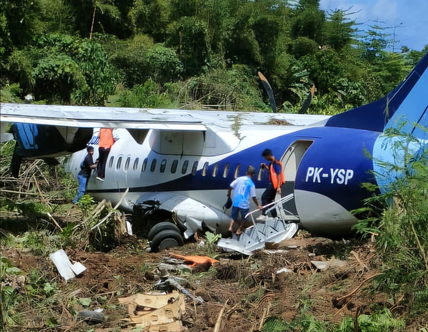
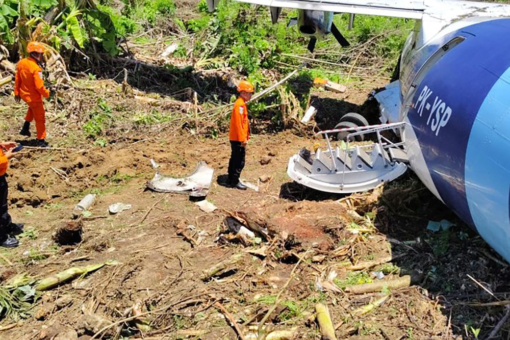
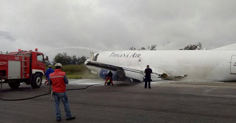
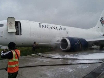
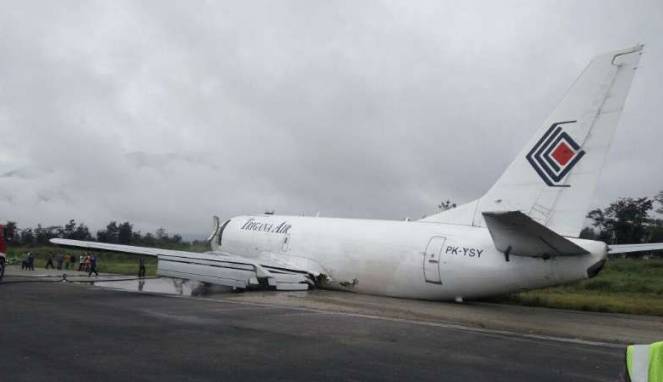
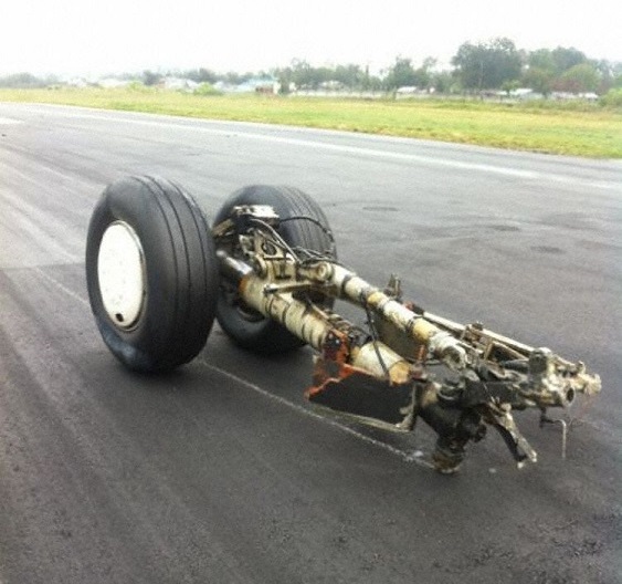
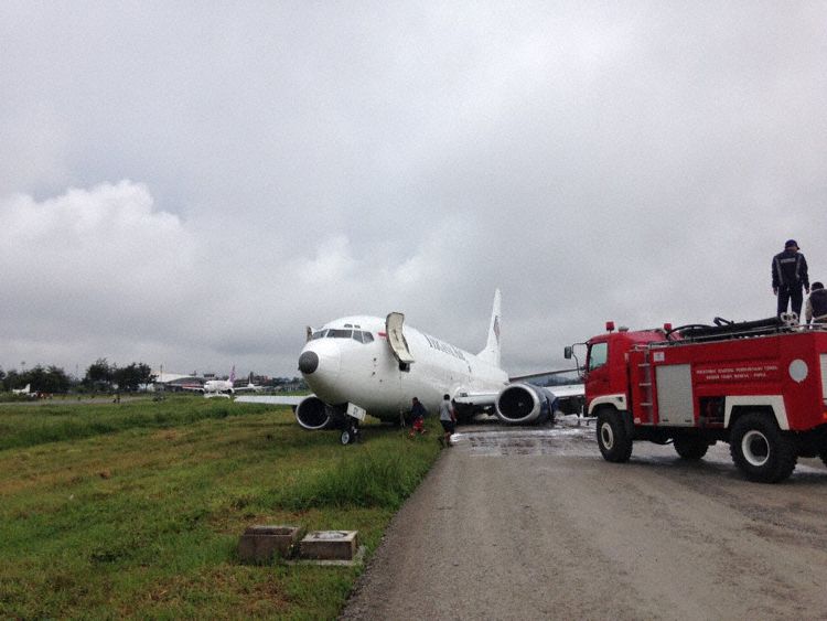
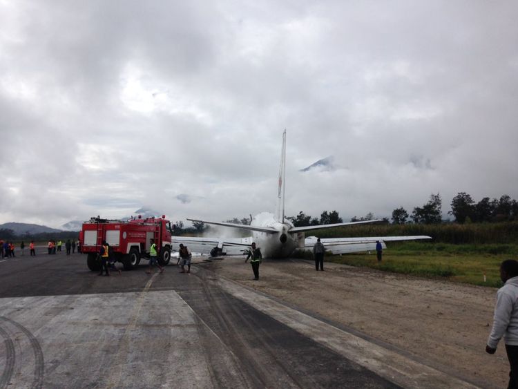
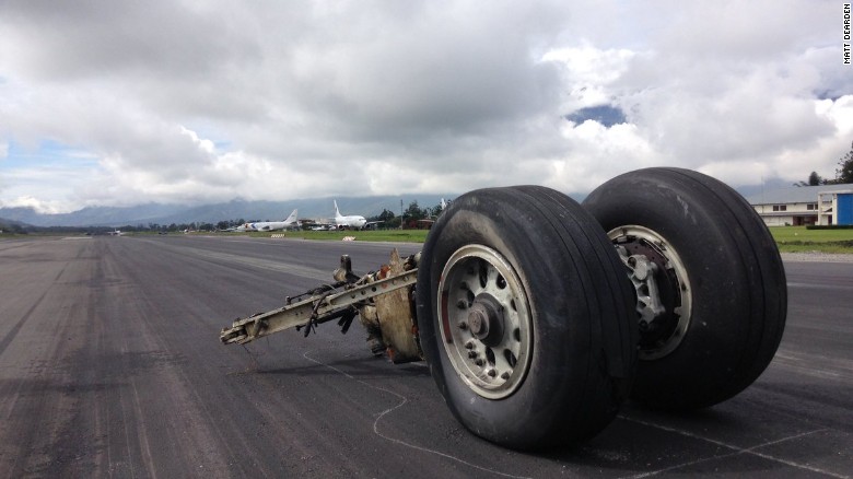
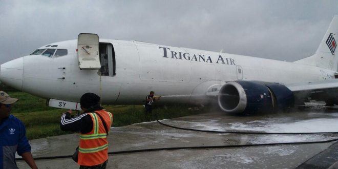
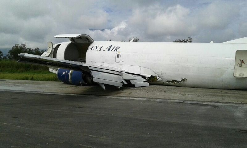
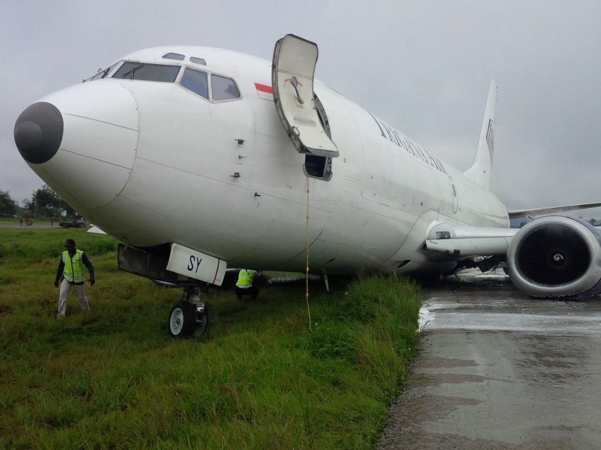
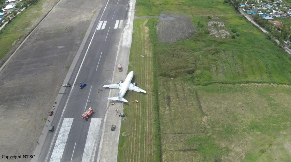
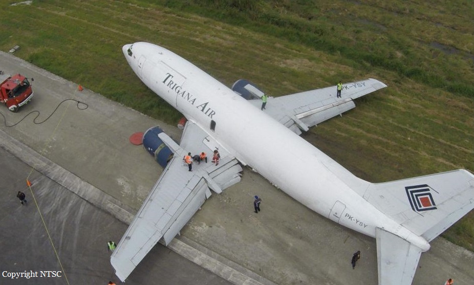
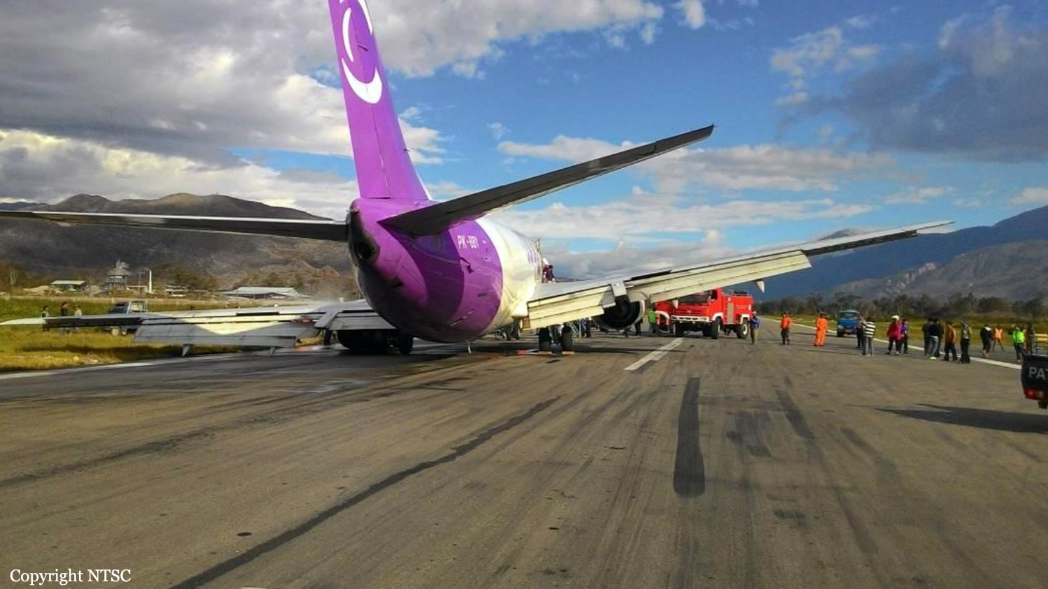
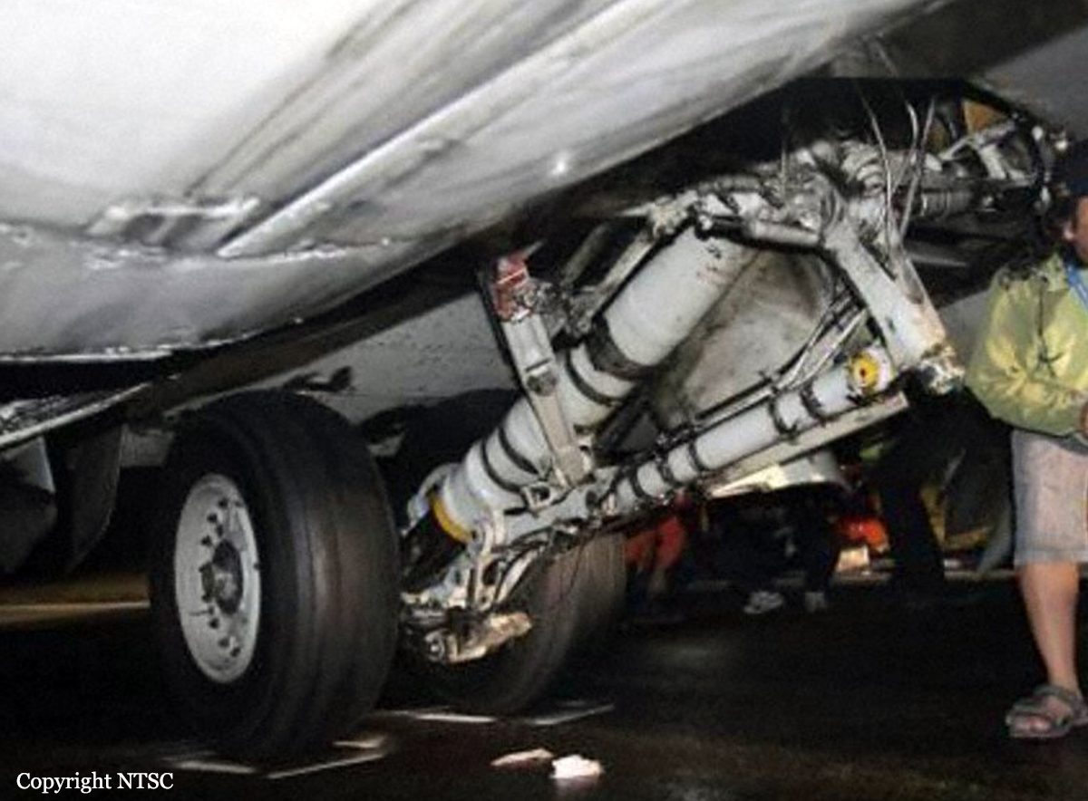
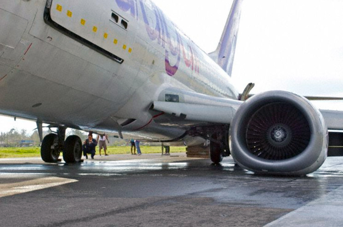
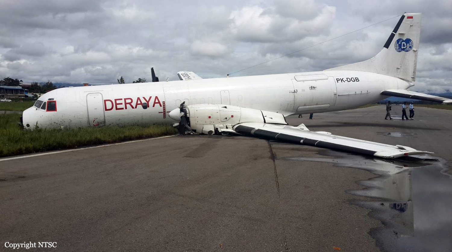
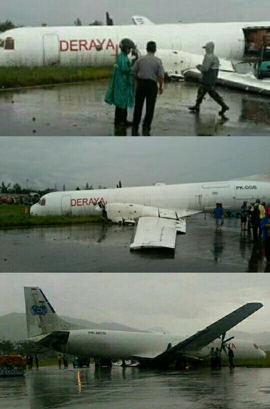
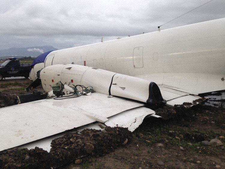
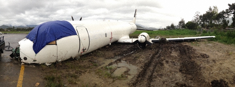
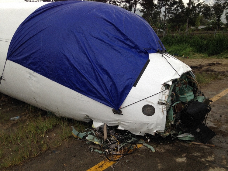
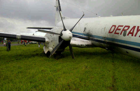
On 13 September 2016, a Boeing 737-300 Freighter, registered PK-YSY was being operated by PT. Trigana Air Service on a scheduled cargo flight from Sentani Airport, Jayapura (WAJJ) to Wamena Airport, Wamena (WAVV), Papua, Indonesia. Approximately 2130 UTC, during the flight preparation, the pilot received weather information which stated that on the right base runway 15 of Wamena Airport, on the area of Mount Pikei, low cloud was observed with the cloud base was increasing from 200 to 1000 feet and the visibility was 3 km. At 2145 UTC, the aircraft departed Sentani Airport with flight number IL 7321 and cruised at altitude 18,000 feet. On board the aircraft was two pilots and one Flight Operation Officer (FOO) acted as loadmaster. The aircraft carried 14,913 kg of cargo. The Pilot in Command (PIC) acted as Pilot Flying (PF) while the Second in Command (SIC) acted as Pilot Monitoring (PM). There was no reported or recorded aircraft system abnormality during the flight until the time of occurrence. After passing point MALIO, the aircraft started to descend. The pilot observed the weather met the criteria of Visual Meteorological Condition (VMC). The pilots able to identify another Trigana flight from Sentani to Wamena in front of them. While passing altitude 13,500 feet, approximately over PASS VALLEY, the Wamena Tower controller instructed the pilot to report position over JIWIKA. When the aircraft position was over point JIWIKA, the Wamena Tower controller informed to the pilot that the flight was on sequence number three for landing and instructed the pilot to make orbit over point X, which located at 8 Nm from runway 15. The pilot made two orbits over Point X to make adequate separation with the aircraft ahead prior to received approach clearance. About 7,000 feet (about 2,000 feet above airport elevation), the pilot could not identify visual checkpoint mount PIKEI and attempted to identify a church which was a check point of right base runway 15. The pilot felt that the aircraft position was on right side of runway centerline. About 6,200 feet (about 1,000 feet above airport elevation), the PF reduced the rate of descend and continued the approach. The PM informed to the PF that runway was not in sight and advised to go around. The PF was confident that the aircraft could be landed safely as the aircraft ahead had landed. Approximately 5,600 feet altitude (about 500 feet above airport elevation) and about 2 Nm from runway threshold the PF was able to see the runway and increased the rate of descend. The pilot noticed that the Enhanced Ground Proximity Warning System (EGPWS) aural warning “SINK RATE” active and the PF reduced the rate of descend. While the aircraft passing threshold, the pilot felt the aircraft sunk and touched down at approximately 125 meters from the beginning runway 15. The Flight Data Recorder recorded the vertical acceleration was 3.25 g on touchdown at 2230 UTC. Both of main landings gear collapsed. The left main landing gear detached and found on runway. The engine and lower fuselage contacted to the runway surface. The aircraft veer to the right and stopped approximately 1,890 meters from the beginning of the runway 15. No one was injured on this occurrence and the aircraft had substantially damage. Both pilots and the load master evacuated the aircraft via the forward left main cargo door used a rope.
Probable cause:
Refer to the previous aircraft that was landed safely, the pilot confidence that a safe landing could be made and disregarding several conditions required for go around.
Final Report:

Crash of a Boeing 737-3Q8 in Wamena

Date & Time: Aug 28, 2015 at 1547 LT
Type of aircraft:
Operator:
Registration:
PK-BBY
Flight Type:
Survivors:
Yes
Schedule:
Jayapura – Wamena
MSN:
23535/1301
YOM:
1986
Flight number:
8F189
Country:
Region:
Crew on board:
2
Crew fatalities:
Pax on board:
0
Pax fatalities:
Other fatalities:
Total fatalities:
0
Captain / Total flying hours:
13880
Captain / Total hours on type:
4877.00
Copilot / Total flying hours:
608
Copilot / Total hours on type:
342
Aircraft flight hours:
54254
Aircraft flight cycles:
38422
Circumstances:
On 28 August 2015 a Boeing 737-300 Freighter, registered PK-BBY was being operated by PT. Cardig Air on a scheduled cargo flight from Sentani Airport (WAJJ) Jayapura to Wamena Airport (WAVV) Papua, Indonesia. At 1234 LT (0334 UTC), the aircraft departed to Wamena and on board the aircraft were two pilots, and 14,610 kg of cargo. The Pilot in Command (PIC) acted as Pilot Flying (PF) while the Second in Command (SIC) who was under line training acted as Pilot Monitoring (PM). There was no reported or recorded aircraft system abnormality during the flight until the time of occurrence. At 0637 UTC, when the aircraft approaching PASS VALLEY, the Wamena Tower controller provided information that the runway in use was runway 15 and the wind was 150°/18 knots, QNH was 1,003 mbs and temperature was 23 °C. At 0639 UTC, the pilot reported position over PASS VALLEY, descended passing FL135. The Wamena Tower controller instructed the pilot to report position over JIWIKA. At 0645 UTC, the pilot reported position over JIWIKA and continued to final runway 15. At 0646 UTC, the pilot reported position on final runway 15 and Wamena Tower controller provided landing clearance with additional information of wind 150°/15 knots and QNH 1,003 mbs. At 0647 UTC, the aircraft touched down about 35 meter before the beginning runway 15 with vertical acceleration of 3.68 G. The left main landing gear collapsed and the left engine contacted to the runway surface. The aircraft stopped at about 1,500 meters from runway threshold. No one was injured on this occurrence.
Probable cause:
According to factual information during the investigation, the Komite Nasional Keselamatan Transportasi determines the findings of the investigation are listed as follows:
1. The pilots held valid licenses and medical certificates.
2. The aircraft had a valid Certificate of Airworthiness (C of A) and Certificate of Registration (C of R), and was operated within the weight and balance envelope.
3. There were no reports of aircraft system abnormalities during the flight.
4. After passed JIWIKA on altitude 10,000 feet, the FDR recorded the engines were on idle, the average rate of descend was approximately 2,000 feet per minute.
5. At altitude approximately 8,000 feet, the flap selected to 40 position and moved to 39.9° one minute 25 seconds later.
6. The BMKG weather report was wind 150°/14-19 knots and the Wamena Tower controller reported to the pilot that the wind was 150°/15 knots. The information of gust wind, which indicated the possibility of windshear, was not reported to the pilot.
7. The EGPWS “CAUTION WINDSHEAR” active on altitude of 5,520 feet.
8. 06:45:43 UTC, the engine power increased when the aircraft altitude was on 5,920 feet prior the EGPWS altitude call “ONE HUNDRED” heard.
9. Started from 06:45:45 UTC, the FDR recorded the CAS increased from 148 knots to 154 knots followed by N1 decreased gradually from 73% to 38%. Three seconds before touched down, the rate of descend was constant on value 1,320 feet per minute followed by EGPWS warning “SINK RATE”.
10. The aircraft touched down at about 35 meters before the beginning runway 15 with the vertical acceleration recorded of 3.68 G.
11. The trunnion link of the left Main Landing Gear (MLG) assembly was found broken and the left main landing gear collapsed.
12. The FDR data contained of 107 flight hours consisted of 170 flight sectors which recorded five times of the vertical acceleration more than 2 G during landing at Wamena. The accumulation of such value of vertical acceleration might lead to landing gear strength degradation.
13. The Visual Approach Slope Indicator (VASI) of runway 15 was not operated after the runway extension.
14. The investigation found several touchdown marks on the pavement before the runway 15.
15. Excessive rubber deposit was found on the surface of runway 15 at about 600 meter started from the runway threshold.
16. The absence of speed correction following the information of headwind of 15 knots and pilot crew briefing after activation of EGPWS caution windshear indicated that the pilot did not aware of the existing windshear, that might be contributed by the absence of gust wind information.
17. The large thrust reduction was not in accordance with the FCOM for windshear precaution and resulted in rapid descend.
18. The accident flight collapsed the landing gear, the FDR recorded the vertical acceleration was 3.683 G which was within the landing gear design limit. This indicated the degradation of landing gear strength.

Contributing Factor:
The large thrust reduction during the windshear resulted in rapid descend and the aircraft touched down with 3.683 G then collapsed the landing gear that had strength degradation.
Final Report:

Crash of an ATR42-300 near Oksibil: 54 killed

Date & Time: Aug 16, 2015 at 1455 LT
Type of aircraft:
Operator:
Registration:
PK-YRN
Flight Phase:
Survivors:
No
Site:
Schedule:
Jayapura - Oksibil
MSN:
102
YOM:
1988
Flight number:
TGN267
Country:
Region:
Crew on board:
4
Crew fatalities:
Pax on board:
50
Pax fatalities:
Other fatalities:
Total fatalities:
54
Captain / Total flying hours:
25287
Captain / Total hours on type:
7340.00
Copilot / Total flying hours:
3818
Copilot / Total hours on type:
2640
Aircraft flight hours:
50133
Aircraft flight cycles:
55663
Circumstances:
An ATR 42-300 aircraft registered PK-YRN was being operated by PT Trigana Air Service on 16 August 2015 as scheduled passenger flight with flight number IL267 from Sentani to Oksibil. On board of this flight were 54 persons. This flight was the fifth flight of the day and the second flight from Sentani to Oksibil. The aircraft departed Sentani at 0522 UTC and estimated time of arrival Oksibil was at 0604 UTC. The Second in Command (SIC) acted as Pilot Flying while the Pilot in Command (PIC) acted as Pilot Monitoring. The weather at Oksibil reported that the cloud was broken (more than half area of the sky covered by cloud) and the cloud base was 8,000 feet (4,000 feet above airport elevation) and the visibility was 4 up to 5 km. The area of final approach path was covered by clouds. The flight cruising at 11,500 feet and at 0555 UTC, the pilot made first contact with Oksibil Aerodrome Flight Information Services (AFIS) officer, reported on descent at position Abmisibil and intended to direct left base leg runway 11. At 0600 UTC, Oksibil AFIS officer expected the aircraft would have been on final but the pilot had not reported, the AFIS officer contacted the pilot but did not reply. The AFIS officer informed Trigana in Sentani that they had lost contact with IL267. The aircraft wreckage was found on a ridge of Tanggo Mountain, Okbape District, Oksibil at approximately 8,300 feet AMSL at coordinates of 04°49’17.34” S, 140°29’51.18” E, approximately 10 NM from Oksibil Aerodrome on bearing of 306°. All occupants were fatally injured and the aircraft was destroyed by impact force and post impact fire. The Flight Data Recorder (FDR) and Cockpit Voice Recorder were recovered and transported to KNKT recorder facility. The recovery of FDR data was unsuccessful while the recovery of CVR data successfully retrieved accident flight data. The CVR did not record any crew briefing, checklist reading not EGPWS warning prior to impact. The CVR also did not record EGPWS altitude call out on two previous flights. The investigation concluded that the EGPWS was probably not functioning.
Probable cause:
The following findings were identified:
1. The aircraft had valid Certificate of Airworthiness and was operated within the weight and balance envelope.
2. All crew had valid licenses and medical certificates.
3. The flight plan form was filed with intention to fly under Instrument Flight Rule (IFR), at flight level 155, with route from Sentani to MELAM via airways W66 then to Oksibil. The MORA of W66 between Sentani to MELAM was 18,500 feet.
4. The flight was the 5th flight of the day for the crew with the same aircraft and the second flight on the same route of Sentani to Oksibil.
5. The CVR data revealed that the previous flight from Sentani to Oksibil the flight cruised at altitude of 11,500 feet and the approach was conducted by direct to left base runway 11.
6. The CVR data also revealed that on the accident flight, the flight cruised at altitude 11,500 feet and intended to direct left base leg runway 11 which was deviate from the operator visual guidance approach that described the procedure to fly overhead the airport prior to approach to runway 11.
7. The witness stated that most of the time, the flight crew deviated from the operator visual approach guidance. The deviation did not identify by the aircraft operator.
8. The downloading process to retrieve data from the FDR was unsuccessful due to the damage of the FDR unit that most likely did not record data during the accident flight. The repetition problems of the FDR unit showed that the aircraft operator surveillance to the repair station was not effective.
9. The CVR did not record any crew briefing, checklist reading and EGPWS altitude callout prior to land on two previous flights nor the EGPWS caution and warning prior to impact.
10. The spectrum analysis of the CVR determined that both engines were operating prior to the impact.
11. Several pilots, had behavior of pulling the EGPWS CB to eliminate the nuisance of EGPWS warning. The pilots stated that the reason for pulling the EGPWS CB was due to the pilots considered this warning activation was not appropriate for the flight conditions. The correction to this behavior was not performed prior to the accident.
12. The investigation could not determine the actual EGPWS CB position during the accident flight.
13. The installation of EGPWS by the aircraft operator was not conducted according to the Service Bulletin issued by the aircraft manufacturer.
14. The terrain data base installed in the EGPWS of PK-YRN was the version MK_VIII_Worldwide_Ver_471 that was released in 2014. The Oksibil Airport was not included in the high-resolution update in this version of terrain database.
15. The information for Oksibil published in AIP volume IV (Aerodrome for Light Aircraft/ALA) did not include approach guidance. The operator issued visual guidance of circling approach runway 11 for internal use.
16. The visual approach guidance chart stated that the minimum safe altitude was 8,000 feet while the aircraft impacted with terrain at approximately 8,300 feet. This indicated an incorrect information in the chart. The investigation considered that the pattern on the approach guidance chart was not easy to fly, as many altitudes and heading changes.
17. Several maintenance records such as component status installed on the aircraft and installation of EGPWS was not well documented. This indicated that the maintenance management was not well performed.
18. The investigation could not find any regulation that describes the pilot training requirement for any addition or modification of aircraft system which affect to the aircraft operation.
19. There was no information related to the status of ZX NDB published on NOTAM prior to the accident.
20. Several safety issues indicated that the organization oversight of the aircraft operator by the regulator was not well implemented.
Contributing Factors:
1. The deviation from the visual approach guidance in visual flight rules without considering the weather and terrain condition, with no or limited visual reference to the terrain resulted in the aircraft flew to terrain.
2. The absence of EGPWS warning to alert the crew of the immediate hazardous situation led to the crew did not aware of the situation.
Final Report:

Crash of a BAe ATP-F in Wamena

Date & Time: Mar 4, 2015 at 1515 LT
Type of aircraft:
Operator:
Registration:
PK-DGB
Flight Type:
Survivors:
Yes
Schedule:
Jayapura – Wamena
MSN:
2029
YOM:
1990
Country:
Region:
Crew on board:
2
Crew fatalities:
Pax on board:
0
Pax fatalities:
Other fatalities:
Total fatalities:
0
Captain / Total flying hours:
3912
Captain / Total hours on type:
833.00
Copilot / Total flying hours:
415
Copilot / Total hours on type:
45
Aircraft flight hours:
200845
Aircraft flight cycles:
27921
Circumstances:
On 4 March 2015 a BAe-ATP registration PK-DGB operated by PT. Deraya Air as scheduled cargo flight from Sentani to Wamena Airport. On board of this flight was two pilots while the Pilot in Command (PIC) acted as pilot flying and First Officer (FO) acted as pilot monitoring. The aircraft departed Sentani at 0524 UTC to Wamena airport. The pilot contacted Wamena Tower controller while position on Jiwika way point at altitude 10,000 feet. Wamena Tower controller instructed to use runway 33 and to proceed to left runway 33. At 0602 UTC the pilot requested to proceed to Pyramid waypoint and to descend to 8,000 feet and made holding due to weather. At 0613, a C-130 pilot that was on approach reported making go around runway 33 and ATC instructed to C-130 pilot to proceed to Pyramid waypoint and hold. At 0619 UTC, Wamena Tower controller informed that the weather reported continuous heavy rain, visibility was reported 2 up to 3 km and wind was from 060° with velocity of 6 knots. The PK-DGB aircraft left Pyramid waypoint for approach runway 33. The aircraft proceed to left downwind and descent to 6,500 feet. During turning base leg, the pilot observed runway insight and continued the approach. At 0620 UTC, the aircraft touched down, thereafter veered off to the right of the runway and skid. The aircraft re-entered the runway at approximately 400 meters from beginning runway 33 and stopped near taxiway Delta at approximately 800 meters from beginning runway 33.

Crash of a Piper PA-31-350 Navajo Chieftain in Langgur: 4 killed

Date & Time: Jan 19, 2014 at 1225 LT
Operator:
Registration:
PK-IWT
Flight Type:
Survivors:
No
Schedule:
Jayapura – Langgur – Kendari – Surabaya
MSN:
31-7752090
YOM:
1977
Country:
Region:
Crew on board:
1
Crew fatalities:
Pax on board:
3
Pax fatalities:
Other fatalities:
Total fatalities:
4
Captain / Total flying hours:
2860
Captain / Total hours on type:
1045.00
Aircraft flight hours:
5859
Circumstances:
On 19 January 2014, a PA-31-350 Piper Chieftain, registered PK-IWT, was being operated by PT. Intan Angkasa Air Service, on positioning flight from Sentani Airport, Jayapura with intended destination of Juanda Airport, Surabaya for aircraft maintenance. The positioning flight was planned to transit at Dumatubun Airport Langgur of Tual, Maluku and Haluoleo Airport, Kendari at South East Sulawesi for refuelling. On the first sector, the aircraft departed Sentani Airport at 2351 UTC (0851 WIT) and estimated arrival at Langgur was 0320 UTC. On board on this flight was one pilot, two company engineers and one ground staff. At 0240 UTC the pilot contacted to the Langgur FISO, reported that the aircraft position was 85 Nm to Langgur Airport at altitude 10,000 feet and requested weather information. Langgur FISO acknowledged and informed that the weather was rain and thunderstorm and the runway in used was 09. When the aircraft passing 5,000 feet, the pilot contacted the Langgur FISO and reported that the aircraft position was 50 Nm from langgur and informed the estimated time of arrival was 0320 UTC. The Langgur FISO acknowledged and advised the pilot to contact when the aircraft was at long final runway 09. At 0318 UTC, the pilot contacted Langgur FISO, reported the position was 25 Nm to Langgur at altitude of 2,500 feet and requested to use runway 27. The Langgur FISO advised the pilot to contact on final runway 27. At 0325 UTC, Langgur FISO contacted the pilot with no reply. At 0340 UTC, Langgur FISO received information from local people that the aircraft had crashed. The aircraft was found at approximately 1.6 Nm north east of Langgur Airport at coordinate 5° 38’ 30.40” S; 132° 45’ 21.57” E. All occupants fatally injured and the aircraft destroyed by impact force and post impact fire. The aircraft was destroyed by impact forces and post impact fire, several parts of the remaining wreckage such as cockpit could not be examined due to the level of damage. The aircraft was not equipped with flight recorders and the communication between ATC and the pilot was not recorded. No eye witness saw the aircraft prior to impact. Information available for the investigation was limited. The analysis utilizes available information mainly on the wreckage information including the information of the wings, engines and propellers.
Probable cause:
The investigation concluded that the left engine most likely failed during approach and the propeller did not set to feather resulted in significant asymmetric forces. The asymmetric forces created yaw and roll tendency and the aircraft became uncontrolled, subsequently led the aircraft to impact to the terrain.
Final Report:

Crash of a BAe ATP in Wamena

Date & Time: May 31, 2013 at 0709 LT
Type of aircraft:
Operator:
Registration:
PK-DGI
Flight Type:
Survivors:
Yes
Schedule:
Jayapura - Wamena
MSN:
2027
YOM:
1990
Country:
Region:
Crew on board:
3
Crew fatalities:
Pax on board:
0
Pax fatalities:
Other fatalities:
Total fatalities:
0
Captain / Total flying hours:
3108
Captain / Total hours on type:
1366.00
Copilot / Total flying hours:
5648
Copilot / Total hours on type:
689
Aircraft flight hours:
15755
Aircraft flight cycles:
25431
Circumstances:
On 31 May 2013 aircraft BAe ATP freighter registered PK-DGI operated by PT. Deraya as scheduled cargo/ freight flight from Sentani Airport (WAJJ) to Wamena Airport (WAJW), Papua. On board in this flight were the Pilot in Command (PIC) acted as Pilot Flying (PF) and the Second in Command (SIC) acted as Pilot Monitoring (PM). At 2127 UTC (0627 LT) the aircraft departed from Sentani Airport. The aircraft cruised at 12,000 feet (FL 120)and estimated time of arrival Wamena Airport was 2207 UTC (0707 LT). The first pilot contact with Wamena Tower controller was at 2201 UTC, the aircraft position was approaching Pass Valley point, the controller informed that runway 15 expect to be used and the weather condition was wind calm, visibility 4 Km, low cloud at final area and QNH 1008 mbs. There was no specific of approach and landing briefing by pilot flying to the pilot non flying considering to such weather condition. At 2207 UTC, the pilot reported the position was on final runway 15. The controller requested the information of the flight condition and the pilot reported that the runway has not insight. At 2209 UTC, the pilot reported that the runway was insight and the controller provided the clearance to land and 25 seconds later the aircraft touched down on the centerline. During the landing roll at about 750 meters from the beginning of runway 15 the aircraft veered to the left of the runway shoulder, the pilot recovered by applying the right rudder and asymmetry reverses thrust but the aircraft continued veer to the left and stopped at about 10 meters on the left shoulder of the runway 15. On the landing roll, the FDR recorded that the left engine torque greater then right engine torque. The pilot shutdown both engines normally and evacuated the aircraft safely. The nose landing gear detached and found on the shoulder at about 250 meter from the aircraft final position. The main landing gears broken and all the propellers bent. No injured in this occurrence.
Probable cause:
The following contributing factors were identified:
- The flight did not meet the criteria according to the recommended elements of stabilized approach which required go around.
- The aircraft touched down with 2° misalignment with the runway direction then the aircraft veered off to the left.
- The recovery action was not in accordance to the correct technique according to the ALAR Tool Kit.
Final Report:

Crash of a PAC 750XL in Abmisibil: 2 killed

Date & Time: Dec 17, 2011 at 0740 LT
Operator:
Registration:
PK-RCD
Survivors:
Yes
Schedule:
Jayapura - Abmisibil
MSN:
149
YOM:
2009
Country:
Region:
Crew on board:
1
Crew fatalities:
Pax on board:
4
Pax fatalities:
Other fatalities:
Total fatalities:
2
Circumstances:
After landing on a wet runway at Abmisibil Airport, the single engine aircraft went out of control, veered off runway and came to rest in a ravine, bursting into flames. The pilot was killed and a passenger died few hours later. All three other occupants were seriously injured and the aircraft was destroyed by impact forces and a post crash fire.

Crash of a PZL-Mielec M-28-05PI in Mulia: 4 killed

Date & Time: Nov 2, 2009 at 1200 LT
Type of aircraft:
Operator:
Registration:
P-4202
Flight Type:
Survivors:
No
Site:
Schedule:
Jayapura – Mulia
MSN:
AJE003-04
YOM:
2004
Country:
Region:
Crew on board:
4
Crew fatalities:
Pax on board:
0
Pax fatalities:
Other fatalities:
Total fatalities:
4
Circumstances:
The twin engine aircraft departed Jayapura-Sentani Airport on a flight to Mulia, carrying four crew members and a load of logistics support dedicated to the Puncak Jaya Police Department. While approaching Mulia in marginal weather conditions, the aircraft struck the slope of a mountain located 33 km northwest of Mulia. The wreckage was found two days later and all four occupants were killed.
Probable cause:
Controlled flight into terrain.

Crash of a De Havilland DHC-6 Twin Otter 300 near Oksibil: 15 killed

Date & Time: Aug 2, 2009 at 1100 LT
Operator:
Registration:
PK-NVC
Flight Phase:
Survivors:
No
Site:
Schedule:
Jayapura - Oksibil
MSN:
626
YOM:
1979
Flight number:
MZ9760D
Country:
Region:
Crew on board:
3
Crew fatalities:
Pax on board:
12
Pax fatalities:
Other fatalities:
Total fatalities:
15
Captain / Total flying hours:
8387
Captain / Total hours on type:
8387.00
Copilot / Total flying hours:
1207
Copilot / Total hours on type:
1207
Aircraft flight hours:
27336
Circumstances:
On the morning of Sunday, 2 August 2009, a de Havilland DHC-6 Twin Otter aircraft, registered PK-NVC, operated by PT. Merpati Nusantara Airlines as flight number MZ-7960D, departed from Sentani Airport, Jayapura for Oksibil Airport. The flight was planned in accordance with the visual flight rules (VFR). There were 15 persons on board; two pilots, one engineer, 10 adult passengers and two infants. The estimated flight time was 50 minutes. The fuel on board was sufficient for 2 hours and 50 minutes flight time. About 15 minutes prior to the estimated time of arrival at Oksibil the crew of another aircraft informed the Twin Otter crew that the weather in the Oksibil area was partly cloudy. There were no further reports of radio transmissions from the Twin Otter, and it did not arrive at Oksibil. A search was initiated at the time the aircraft would have run out of fuel. On the morning of 4 August 2009, searchers located the wreckage of the Twin Otter at an elevation of about 9,300 feet about 6 Nm from Oksibil. The aircraft was destroyed by impact forces, and all of the occupants were fatally injured.
Probable cause:
The pilots did not maintain visual flight procedures when flying below lowest safe altitude, and the aircraft was flown into cloud in the vicinity of gap north west of Oksibil. In conclusion, the accident was consistent with controlled flight into terrain.
Final Report: