Country
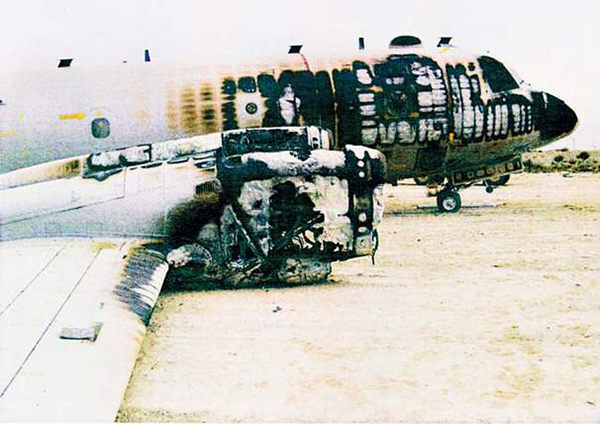
Crash of a Lockheed P-3C-140-LO Orion at Bagram AFB
Date & Time:
Oct 21, 2008
Operator:

Registration:
158573
Survivors:
Yes
MSN:
5582
YOM:
1972
Crew on board:
0
Crew fatalities:
Pax on board:
0
Pax fatalities:
Other fatalities:
Total fatalities:
0
Circumstances:
After landing at Bagram AFB, the crew encountered difficulties to decelerate properly. Unable to stop within the remaining distance, the aircraft overran, lost its right main gear and came to rest, bursting into flames. There were no injuries among the occupants and the aircraft was damaged beyond repair.
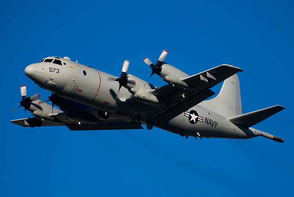
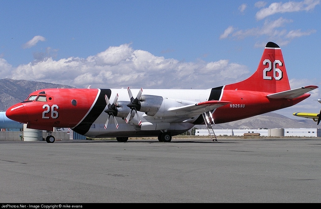
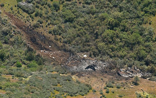
Crash of a Lockheed P-3V-1 Orion near Chico: 3 killed
Date & Time:
Apr 20, 2005 at 1850 LT
Operator:

Registration:
N926AU
Survivors:
No
Schedule:
Chico - Chico
MSN:
185-5171
YOM:
1963
Crew on board:
3
Crew fatalities:
Pax on board:
0
Pax fatalities:
Other fatalities:
Total fatalities:
3
Captain / Total hours on type:
2915.00
Copilot / Total hours on type:
192
Aircraft flight hours:
15614
Circumstances:
Prior to the accident flight, the air tanker airplane had flown 9 times on the day of the accident, for a total flight time of 5 hours and 46 minutes. The purpose of the flights was to provide recurrent training for pilots scheduled to conduct fire-fighting operations for the United States Department of Agriculture Forest Service (USFS) during the upcoming fire season. Pilots aboard the airplane during the earlier flights reported no mechanical problems with the airplane. As was the mission for other flights that day, the accident flight, the tenth flight, was a training flight to conduct practice drops of water over an area of rugged mountainous terrain located north of the airport. Aboard the flight were the captain, the copilot, and the company's Chief Pilot, who was providing flight instruction. The Chief Pilot had been on board all the flights that day. Radar data indicated that the flight departed the airport and proceeded about 10.5 nautical miles to the north where it began maneuvering in a manner consistent with the conduct of practice water drops. The data showed the airplane entering and then following a right-hand racetrack pattern oriented northeast-southwest, during which it appeared that practice drops were being made on the southwest leg. During the last minute of the flight, the airplane was on the northeast leg of the racetrack pattern, flying up a valley that was oriented northeast-southwest with uphill being to the northeast. The airplane's flight path was initially near the middle of the valley. During the last 36 seconds of the flight, the airplane's flight path began to deviate towards the rising terrain on the eastern side of the valley. The last two radar hits show the airplane at an altitude of less than 100 feet above ground level. The airplane had completed approximately 1.75 circuits of the racetrack when the data ended with the airplane at 2,900 feet msl, heading northeast. The initial impact point was located about 2,150 feet northwest of the last radar data point at an elevation of about 2,450 feet msl, indicating the airplane entered a left descending turn and completed about 90 degrees of turn between the last radar hit and the impact. No distress calls were received from the airplane. According to local authorities, witnesses observed a "fire ball" at the time of the accident. Examination of the wreckage site revealed that the airplane impacted on about a 304 degree magnetic heading in a 40 degree left bank with the left wingtip striking the ground first. The airplane was severely fragmented and a severe post crash fire burned most of the structure and surrounding vegetation. Remnants of the entire airplane were accounted for at the wreckage site. There was no evidence of pre-existing structural failures or impact with foreign objects in any of the wreckage. All four of the engines and propellers were found at the wreckage site. The engines did not have any indications of an uncontainment, case rupture, or pre-impact in-flight fire. All four engines had damage to the compressor and/or turbine rotors that was consistent with engine operation. The cockpit engine instrumentation gages indicate that all four engines were running at about 2,200 shaft horsepower at impact. Review of the airplane's maintenance records did not reveal any chronic issues with the airplane nor any system/component anomalies that would have contributed to the accident. The airplane was equipped with neither a cockpit voice recorder (CVR) nor a flight data recorder (FDR) and Federal Aviation Regulations did not require the airplane to be so equipped. The reason for the in-flight collision with terrain could not be determined.
Probable cause:
Terrain clearance was not maintained while maneuvering for undetermined reasons. Mountainous terrain was a factor.
Final Report:
Crash of a Lockheed P-3C-II.75 Orion off Pasni: 21 killed
Date & Time:
Oct 29, 1999
Operator:

Registration:
83
Survivors:
No
Schedule:
Pasni - Pasni
MSN:
185-5827
YOM:
1988
Crew on board:
21
Crew fatalities:
Pax on board:
0
Pax fatalities:
Other fatalities:
Total fatalities:
21
Circumstances:
Crashed in unknown circumstances in the sea off Pasni while completing a maritime patrol flight. All 21 occupants were killed.
Crash of a Lockheed EP-3E Orion in Chania
Date & Time:
Sep 23, 1997
Operator:
Registration:
157320
Survivors:
Yes
MSN:
185-5535
YOM:
1968
Crew on board:
4
Crew fatalities:
Pax on board:
22
Pax fatalities:
Other fatalities:
Total fatalities:
0
Circumstances:
After touchdown at Chania-Souda Airport, the four engine aircraft went out of control, veered off runway, lost its undercarriage and came to rest. All 26 occupants escaped uninjured while the aircraft was written off.
Probable cause:
Loss of control upon landing following a wrong approach configuration and an excessive speed.
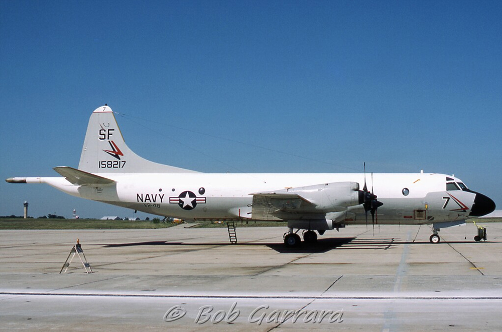
Crash of a Lockheed P-3C-130-LO Orion off Masirah Island
Date & Time:
Mar 25, 1995
Operator:
Registration:
158217
Survivors:
Yes
Schedule:
Masirah - Masirah
MSN:
185-5562
YOM:
1971
Crew on board:
11
Crew fatalities:
Pax on board:
0
Pax fatalities:
Other fatalities:
Total fatalities:
0
Circumstances:
While completing a maritime survey flight off Masirah Island, the crew encountered technical difficulties when the propeller detached from the engine n°4 that caught fire. Shortly later, the engine n°3 lost power then engine n°1 & 2 also lost power and failed. The aircraft lost height but the crew was able to regain control at 2,500 feet and eventually ditched the aircraft 8 km offshore. All 11 occupants were quickly rescued while the aircraft sank and was lost.