Crash of a Douglas C-54E-15-DO Skymaster in Diavik

Date & Time: Aug 28, 2002 at 1650 LT
Type of aircraft:
Operator:
Registration:
C-GQIC
Flight Type:
Survivors:
Yes
Schedule:
Yellowknife – Diavik
MSN:
27343
YOM:
1944
Flight number:
BFL928
Country:
Crew on board:
2
Crew fatalities:
Pax on board:
0
Pax fatalities:
Other fatalities:
Total fatalities:
0
Circumstances:
On final approach to Diavik Airport, the four engine aircraft was too low. This caused the undercarriage to struck the ground about one metre short of runway 10 threshold. On impact, the undercarriage were torn off and the aircraft slid on the runway for almost 300 metres then lost its right wing and rotated to the right before coming to rest, bursting into flames. Both pilots escaped with minor injuries and the aircraft was destroyed.

Crash of a Piper PA-31-350 Navajo Chieftain in Fort Liard: 3 killed

Date & Time: Oct 15, 2001 at 2233 LT
Operator:
Registration:
C-GIPB
Survivors:
Yes
Schedule:
Yellowknife – Fort Liard
MSN:
31-7852170
YOM:
1978
Country:
Crew on board:
1
Crew fatalities:
Pax on board:
5
Pax fatalities:
Other fatalities:
Total fatalities:
3
Captain / Total flying hours:
1157
Captain / Total hours on type:
77.00
Aircraft flight hours:
11520
Circumstances:
A Piper PA-31 Navajo Chieftain, C-GIPB, serial number 31-7852170, departed Yellowknife, Northwest Territories, at 2043 mountain daylight time on a night instrument flight rules (IFR) charter flight to Fort Liard. One pilot and five passengers were on board. On arrival at Fort Liard, in conditions of moderate to heavy snow, the pilot initiated a non-directional beacon approach with a circling procedure for Runway 02. At about 2233, the aircraft struck a gravel bar on the west shoreline of the Liard River, 1.3 nautical miles short of the threshold of Runway 02, and 0.3 nautical mile to the left of the runway centreline. The aircraft sustained substantial damage, but no fire ensued. Three passengers were fatally injured, and the pilot and two passengers were seriously injured. The emergency locator transmitter activated and was received by the search and rescue satellite system, and two Canadian Forces aircraft were dispatched to conduct a search. The wreckage was electronically located the following morning, and a civilian helicopter arrived at the accident site approximately 10 hours after the occurrence.
Probable cause:
Findings as to Causes and Contributing Factors:
1. For undetermined reasons, the pilot did not maintain adequate altitude during a night circling approach in IMC and the aircraft struck the ground.
2. The pilot and front seat passenger were not wearing available shoulder harnesses, as required by regulation, which likely contributed to the severity of their injuries.
Findings as to Risk:
1. The aircraft was not fitted with, and was not required to be fitted with, a GPWS or a radio altimeter.
2. The pilot used an unauthorized remote altimeter setting that would have resulted in the cockpit altimeters reading approximately 200 feet higher than the actual altitude.
3. The pilot did not meet the night recency requirements necessary to carry passengers, as specified in CAR 401.05 (2).
4. Risk management responsibilities had been placed almost entirely on the pilot.
5. While the company had taken the voluntary initiative to appoint a safety officer, and appeared to have a safety program in place, the program may not have been directed at the needs.
Other Findings:
1. Approximately 28 hours of flight time that the pilot had logged as multi-engine dual would not have qualified as flight experience for the issue of a higher license.
2. CAR do not define 'flight familiarization', 'flight experience', or 'dual', and therefore do not address flight time 'quality'.
3. Opportunities for local community searchers to identify and access the accident site earlier were hampered by initial inaccurate SARSAT location information, by the time required to locate SAR aircraft to the Fort Liard area, and by darkness and poor weather conditions.
4. The decreased time required to alert the SAR system and the higher degree of accuracy permitted by the utilization of a 406 MHz ELT, particularly one interfaced with the onboard GPS, would have likely permitted rescuers to access the site in a more timely manner.
5. 703 Air Taxi operations continue to have a much higher accident rate than 704 Commuter and 705 Airline operations.
Final Report:

Crash of a Boeing 737-210C in Yellowknife

Date & Time: May 22, 2001 at 1325 LT
Type of aircraft:
Operator:
Registration:
C-GNWI
Survivors:
Yes
Schedule:
Edmonton – Yellowknife
MSN:
21066
YOM:
1975
Flight number:
7F953
Country:
Crew on board:
6
Crew fatalities:
Pax on board:
98
Pax fatalities:
Other fatalities:
Total fatalities:
0
Captain / Total flying hours:
16400
Captain / Total hours on type:
7000.00
Copilot / Total flying hours:
9500
Copilot / Total hours on type:
840
Circumstances:
First Air Flight 953, a Boeing 737-210C, serial number 21066, was on a scheduled flight from Edmonton, Alberta, to Yellowknife, Northwest Territories. On board were 2 flight crew, 4 cabin crew, and 98 passengers. The flight departed Edmonton at 1130 mountain daylight time, with an estimated time en route of 1 hour 35 minutes. As the aircraft approached Yellowknife, the spoilers were armed, and the aircraft was configured for a visual approach and landing on Runway 33. The computed Vref was 128 knots, and target speed was 133 knots. While in the landing flare, the aircraft entered a higher-than-normal sink rate, and the pilot flying (the first officer) corrected with engine power and nose-up pitch. The aircraft touched down on the main landing gear and bounced twice. While the aircraft was in the air, the captain took control and lowered the nose to minimize the bounce. The aircraft landed on its nose landing-gear, then on the main gear. The aircraft initially touched down about 1300 feet from the approach end of Runway 33. Numerous aircraft rubber scrub marks were present in this area and did not allow for an accurate measurement. During the third touchdown on the nose landing-gear, the left nose-tire burst, leaving a shimmy-like mark on the runway. The aircraft was taxied to the ramp and shut down. The aircraft was substantially damaged. There were no reported injuries to the crew or the passengers. The accident occurred at 1325, during the hours of daylight.
Probable cause:
Findings as to Causes and Contributing Factors:
1. Incorrect bounced landing recovery procedures were carried out when the captain pushed forward on the control column to prevent a further bounce, and the aircraft landed nosewheel first.
2. The high sink rate on the initial flare was not recognized and corrected in time to prevent a bounced landing and a subsequent bounced landing.
Other Findings:
1. The power increase during the flair resulted in the speedbrake/spoilers retracting.
2. The captain had not received a line check of at least three sectors before returning to flight duties, although this check was required to regain competency after pilot proficiency check expiry.
Final Report:

Crash of a Short SC.7 Skyvan 3 Variant 100 in Port Radium: 3 killed

Date & Time: Oct 8, 2000 at 1520 LT
Type of aircraft:
Operator:
Registration:
C-FSDZ
Flight Type:
Survivors:
No
Schedule:
Yellowknife – Kugluktuk – Port Radium – Yellowknife
MSN:
1953
YOM:
1977
Country:
Crew on board:
2
Crew fatalities:
Pax on board:
1
Pax fatalities:
Other fatalities:
Total fatalities:
3
Captain / Total flying hours:
22000
Captain / Total hours on type:
1000.00
Copilot / Total flying hours:
280
Copilot / Total hours on type:
100
Circumstances:
At 1108 mountain daylight time on 08 October 2000, the Summit Air Charter's Short Brothers SC-7 Skyvan, serial number SH1953, departed on a visual flight rules six-hour flight from Yellowknife, Northwest Territories, to Kugluktuk, Nunavut, to Port Radium, Northwest Territories, and back to Yellowknife. The flight plan indicated a one-hour stop in Kugluktuk, with an estimated time of arrival at Yellowknife of 1710. The pilot-in-command was the chief pilot of Summit Air Charters Ltd. A cargo handler, who was also a pilot, was in the co-pilot's seat, and there was one passenger. When the aircraft failed to arrive at Yellowknife, Search and Rescue (SAR) were alerted and a search was begun. At 2202 SAR personnel confirmed that the SAR satellite was picking up an emergency locator transmitter signal in the vicinity of Port Radium. SAR aircraft were directed to the signal location and found the signal source but were not able to see the wreckage because of fog and freezing rain. The wreckage was found at 1309 the following day. The aircraft had struck the top of steeply rising hills along the east shore of Great Bear Lake, approximately 2.9 nautical miles northeast of the Port Radium airstrip. The crash site is approximately 440 feet above the lake surface and 250 feet above the airstrip elevation (see Appendix A). The aircraft was destroyed, and the three persons on board were fatally injured.
Probable cause:
Findings as to Causes and Contributing Factors:
1. Although the pilot and the aircraft were certified for instrument flight, the pilot apparently continued to fly in accordance with visual flight rules after encountering marginal weather conditions and reduced visibility.
2. For undetermined reasons, the pilot descended below the elevation of the terrain surrounding the airstrip, resulting in a controlled-flight-into-terrain accident.
Finding as to Risk:
1. Given the pilot's flying time during the 30 days before the accident, the pilot=s performance might have been affected by fatigue.
Final Report:

Crash of a De Havilland DHC-6 Twin Otter 300 in Markham Bay: 2 killed

Date & Time: Aug 12, 1996 at 1347 LT
Operator:
Registration:
C-GNDN
Flight Type:
Survivors:
No
Schedule:
Iqaluit - Markham Bay - Lake Harbour
MSN:
427
YOM:
1974
Flight number:
7F064
Country:
Crew on board:
2
Crew fatalities:
Pax on board:
0
Pax fatalities:
Other fatalities:
Total fatalities:
2
Captain / Total flying hours:
3813
Captain / Total hours on type:
2028.00
Copilot / Total flying hours:
2724
Copilot / Total hours on type:
1000
Circumstances:
First Air 064, a DHC-6 Twin Otter (Serial No. 427), took off from Iqaluit, Northwest Territories (NWT), at 1258 Coordinated Universal Time (UTC) on a charter flight to Markham Bay, Lake Harbour, and back to Iqaluit. The aircraft was carrying six barrels of Jet B fuel to be delivered to Markham Bay, an off-strip landing site. At 1300, just after he took off, the captain told the Iqaluit Flight Service Station (FSS) specialist that the estimated time of arrival (ETA) for Markham Bay would be 1335. At approximately 1345, the crew informed First Air dispatch that they were landing at Markham Bay. After touching down, the pilot attempted an overshoot. During the attempt, the aircraft struck the ground about 200 metres past the end of the landing area, got airborne again, cleared a ridge, then crashed onto a rocky beach. A helicopter located the airplane 629 metres from the beginning of the landing area, partially submerged in water. The two pilots, the only occupants, received fatal injuries in the crash.
Probable cause:
For unknown reasons, a decision was made to overshoot even though insufficient runway remained for acceleration, take-off, and climb. Likely contributing directly to the decision to overshoot was the difficulty in controlling the aircraft on touchdown.
Final Report:

Crash of a Douglas C-47A-5-DK in Fort Simpson

Date & Time: Jun 26, 1994 at 1404 LT
Operator:
Registration:
C-FROD
Flight Type:
Survivors:
Yes
Schedule:
Big Trout Lake – Fort Simpson
MSN:
12307
YOM:
1942
Flight number:
BFL526
Country:
Crew on board:
2
Crew fatalities:
Pax on board:
0
Pax fatalities:
Other fatalities:
Total fatalities:
0
Captain / Total flying hours:
14000
Captain / Total hours on type:
9000.00
Copilot / Total flying hours:
1300
Copilot / Total hours on type:
850
Aircraft flight hours:
18456
Circumstances:
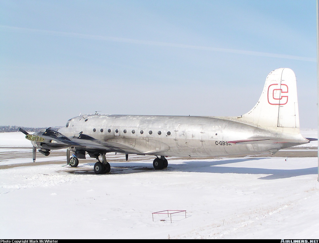
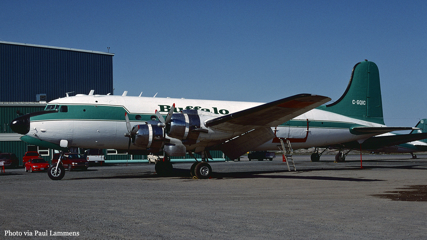
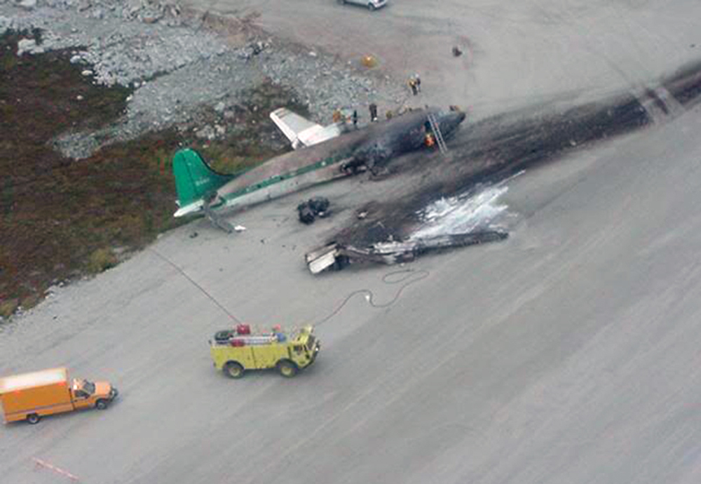
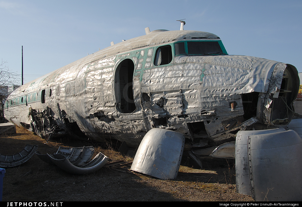
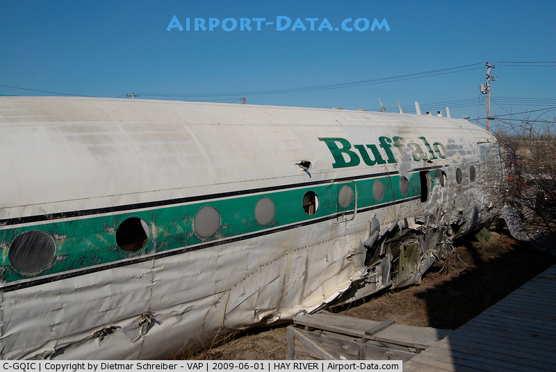
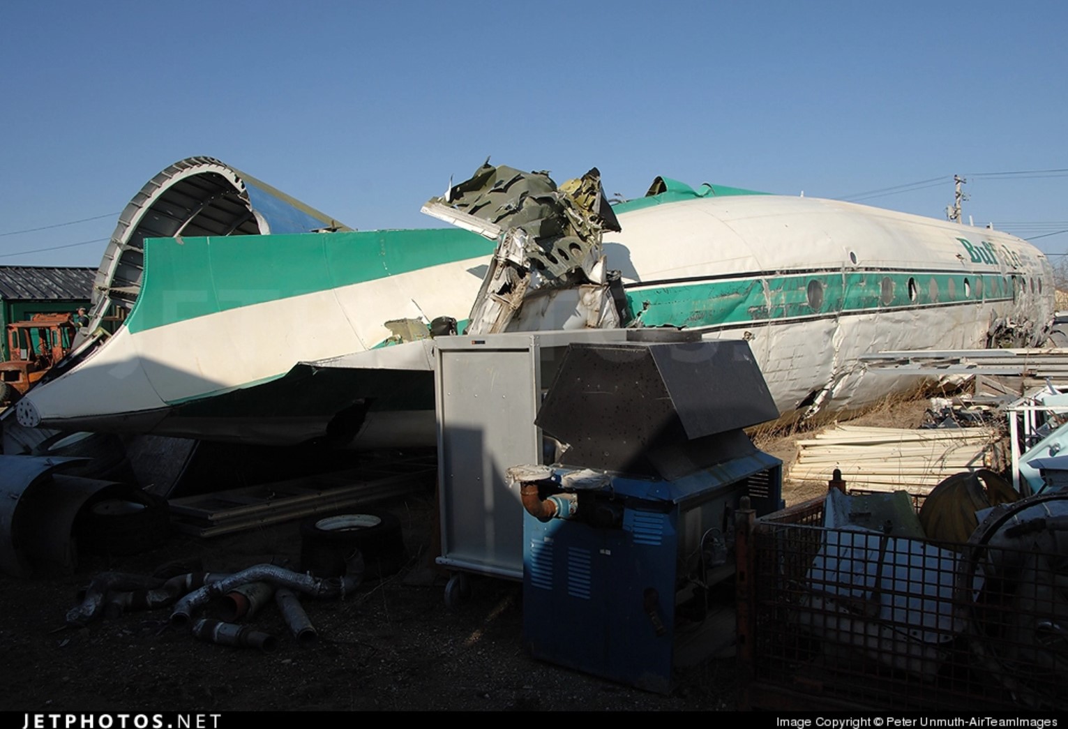
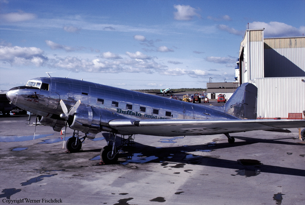
Buffalo Air Flight 526, a Douglas DC-3C freighter based in Yellowknife, was hauling jet fuel to Trout Lake from Fort Simpson, Northwest Territories, in support of forest fire suppression operations. Before the departure from Yellowknife to Trout Lake, the flight crew checked the en route weather and filed a company flight itinerary. Dispatch issued the flight crew an aircraft-fuel-load receipt which indicated that the aircraft had been fuelled the night before with a total fuel quantity of about 436 imperial gallons (imp. gal.): full main tanks (336 imp. gal.), and 50 gallons in each auxiliary tank (100 imp. gal.). The first officer confirmed this quantity with a fuel dip-stick borrowed from the refueller. At 07:40 mountain daylight saving time, the flight crew departed Yellowknife in accordance with visual flight rules (VFR). On board the aircraft were 17 full 45-imperial-gallon drums of Turbo-B jet fuel. At 09:25 the aircraft landed at Trout Lake, and the 17 drums of jet fuel were off-loaded; the aircraft then departed for Fort Simpson at 0945. The 82-nautical-mile (nm) flight to Fort Simpson was flown at an altitude of about 2,500 feet above sea level (asl); the flight crew reported encountering light headwinds. At 10:20 the aircraft landed at Fort Simpson. Once again 17 drums of jet fuel were loaded on board, then the aircraft departed at 10:49. The captain climbed the aircraft to an altitude of 3,500 feet asl. After he levelled off the aircraft, the captain adjusted the engines to 575 brake horsepower (bhp) settings. At 11:20, the aircraft landed at Trout Lake and the drums were off-loaded, and at 11:35 the aircraft was once again airborne on the second round-trip shuttle flight. Thirty-five minutes later the aircraft landed at Fort Simpson. While the cargo was being loaded on the aircraft, the flight crew discussed their different calculations regarding the aircraft's fuel quantity. The first officer indicated that the aircraft required fuel. The captain calculated that the aircraft had sufficient fuel remaining. The captain decided that they would refuel at Fort Simpson on the next shuttle flight; nonetheless, since the flight crew considered the cockpit fuel gauges unreliable, the captain requested that the first officer confirm the fuel quantity using a dip-stick. At 12:28, the aircraft departed Fort Simpson and climbed to 5,000 feet asl. About eight minutes later, the flight crew noticed that the fuel pressure was fluctuating, indicating that the auxiliary tanks were empty. The captain repositioned the fuel tank selectors to their respective main tanks and enquired about the dip-stick measurements. The first officer responded that he had not checked the fuel quantity because the fuel dip-stick was missing. The crew discussed the fuel quantity remaining and the captain calculated that the aircraft had approximately 45 minutes of fuel remaining. Following the 13:00 touchdown at Trout Lake, the cargo was unloaded and 31 empty fuel drums were loaded on board the aircraft for Fort Simpson. At 13:25 the aircraft departed Trout Lake. The first officer was the pilot flying (PF) the aircraft, and was in the right seat. The captain performed the duties of the pilot not flying (PNF). Twenty miles southwest of Fort Simpson, the PNF reported their position to Fort Simpson Flight Service Station (FSS). He also requested that the aircraft refueller be advised that they would require fuel on arrival. The flight crew then completed the descent checks and, at 10 miles southwest of the airport, the PNF updated FSS of their position and received the airport advisory. Approximately six miles from the airport, at an altitude of about 400 to 500 feet above ground level (agl), the PF advised the PNF that the left engine was losing fuel pressure. Shortly thereafter, the left engine lost power. Immediately, the PNF switched the left fuel boost pump to the ON position, and the left fuel selector from LEFT MAIN to LEFT AUXILIARY tank position. The engine resumed power momentarily, but lost power again. The PNF then switched the left fuel selector to the RIGHT AUXILIARY tank position and the engine regained power; however, it promptly lost power again. Realizing that the fuel had been depleted in three of the four tanks, the captain took control of the aircraft and headed straight for runway 31. As the captain called for the engine failure check for the left engine, the first officer advised the captain that the right engine was losing power. With a loss of power in both engines, and without sufficient altitude to glide to the airport, the first officer called the Fort Simpson FSS to advise that the flight crew would attempt a landing on the road (Mackenzie Highway) north of the Liard River. However, the approach to the road was unsuccessful and the aircraft crash-landed into a treed area. At about 14:03, several witnesses at the Liard River ferry crossing observed the aircraft flying low in a northwesterly direction. The aircraft was estimated to be at about 40 feet agl when it crossed overhead the ferry terminal and was descending. The witnesses reported that they heard the sound of the engines cutting in and out before the aircraft passed overhead their vantage points. They also reported seeing the landing gear being extended. The aircraft then disappeared from view behind the trees. Immediately thereafter, the aircraft struck trees near the road, and crashed about 1/2 nm short of runway 31. The aircraft had been flown for approximately 4 hours and 37 minutes since its last refuelling.
Probable cause:
The flight was commenced with a fuel quantity below the minimum requirements, resulting in loss of engine power because of fuel exhaustion. Contributing to the occurrence was the lack of flight crew coordination.
Final Report:

Crash of a Britten-Norman BN-2A-27 Islander near Tuktoyaktuk: 7 killed

Date & Time: Dec 3, 1993 at 1713 LT
Type of aircraft:
Registration:
C-GMOP
Flight Phase:
Survivors:
No
Schedule:
Tuktoyaktuk - Inuvik
MSN:
398
YOM:
1974
Country:
Crew on board:
1
Crew fatalities:
Pax on board:
6
Pax fatalities:
Other fatalities:
Total fatalities:
7
Captain / Total flying hours:
3224
Captain / Total hours on type:
848.00
Aircraft flight hours:
9391
Circumstances:
On 03 December 1993, a Britten-Norman BN2A-20 Islander, registration C-GMOP, owned and operated by Arctic Wings and Rotors, departed Tuktoyaktuk, Northwest Territories, on a night
visual flight rules (VFR) flight to the Inuvik townsite airstrip. On board were the pilot and six passengers. The pilot took off from runway 09 at 1706:34 mountain standard time (MST) , and had turned the aircraft to a southerly direction when the right engine (Textron Lycoming IO540-K1B5) lost all power. At 1710:40, the pilot reported to Tuktoyaktuk Flight Service Station (FSS) that he had an engine problem and was trying to get back to the airport. At 1711:44, he reported that he was "presently heading back to the airport at this time." At 1711:58, he reported "showing six miles back from the airport at this time." The FSS specialist asked if he was declaring an emergency, and the pilot's response was indecisive. During the last radio transmission, there were indications of stress in the pilot's voice; however, there was no further mention of the specific nature of the problem. The pilot did not report his altitude during the conversations with the FSS. The transmission lasted approximately 15 seconds and ended at 1713:03. When the aircraft did not return to the airport, an air and ground search was initiated. The aircraft was located on an ice-covered lake approximately eight miles southeast of the airport. The aircraft struck the ice in a steep nose-down attitude. The engines and front of the aircraft penetrated the approximately two-foot-thick layer of ice. The remainder of the fuselage, wings, and empennage remained on the ice surface. The seven occupants were fatally injured. The accident occurred during the hours of darkness at approximately 1713 MST, at latitude 69°20'N, longitude 132°56'W, at an elevation of approximately 50 feet above sea level (asl).
Probable cause:
A magneto impulse coupling, worn beyond the prescribed limits, resulted in the failure of the right engine. Following the engine failure, the pilot mistrimmed the rudder and was unable to maintain control of the aircraft.
Final Report:

Crash of a De Havilland DHC-6 Twin Otter 300 in Thistle Lake: 2 killed

Date & Time: Jun 21, 1990 at 1915 LT
Registration:
C-FWAB
Flight Phase:
Flight Type:
Survivors:
No
MSN:
349
YOM:
1973
Country:
Crew on board:
2
Crew fatalities:
Pax on board:
0
Pax fatalities:
Other fatalities:
Total fatalities:
2
Circumstances:
The crew just departed Thistle Lake after delivering cargo for local mine workers. Just after liftoff, while climbing to a height of about 10 feet, the aircraft banked right and struck the rotor of a parked Bell 206. Out of control, it crashed few dozen meters further, bursting into flames. Both pilots were killed.
Probable cause:
The reason of the loss of control could not be determined.

Crash of a Britten-Norman BN-2A-27 Islander in Inuvik

Date & Time: Jan 26, 1990
Type of aircraft:
Registration:
C-GSAF
Flight Phase:
Survivors:
Yes
MSN:
263
YOM:
1971
Country:
Crew on board:
0
Crew fatalities:
Pax on board:
0
Pax fatalities:
Other fatalities:
Total fatalities:
0
Circumstances:
Crashed in unknown circumstances. There were no casualties.

Crash of a Piper PA-31T-1040 Cheyenne III in Sachs Harbour: 5 killed

Date & Time: Sep 22, 1989
Type of aircraft:
Operator:
Registration:
C-GBDH
Survivors:
No
MSN:
31-8375003
YOM:
1983
Country:
Crew on board:
1
Crew fatalities:
Pax on board:
4
Pax fatalities:
Other fatalities:
Total fatalities:
5
Circumstances:
On final approach to Sachs Harbour Airport, the pilot encountered limited visibility due to fog when the aircraft crashed in a lake located 600 meters short of runway. All five occupants were killed.