Country
Operator Image

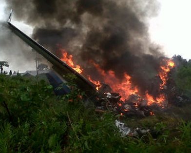
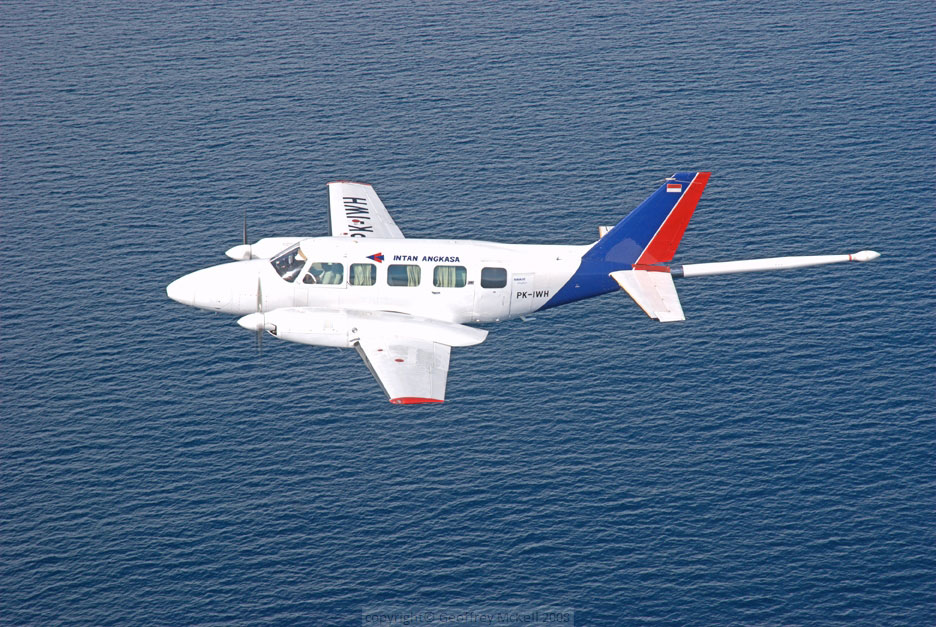
Crash of a Piper PA-31-350 Navajo Chieftain in Langgur: 4 killed

Date & Time: Jan 19, 2014 at 1225 LT
Operator:
Registration:
PK-IWT
Flight Type:
Survivors:
No
Schedule:
Jayapura – Langgur – Kendari – Surabaya
MSN:
31-7752090
YOM:
1977
Country:
Region:
Crew on board:
1
Crew fatalities:
Pax on board:
3
Pax fatalities:
Other fatalities:
Total fatalities:
4
Captain / Total flying hours:
2860
Captain / Total hours on type:
1045.00
Aircraft flight hours:
5859
Circumstances:
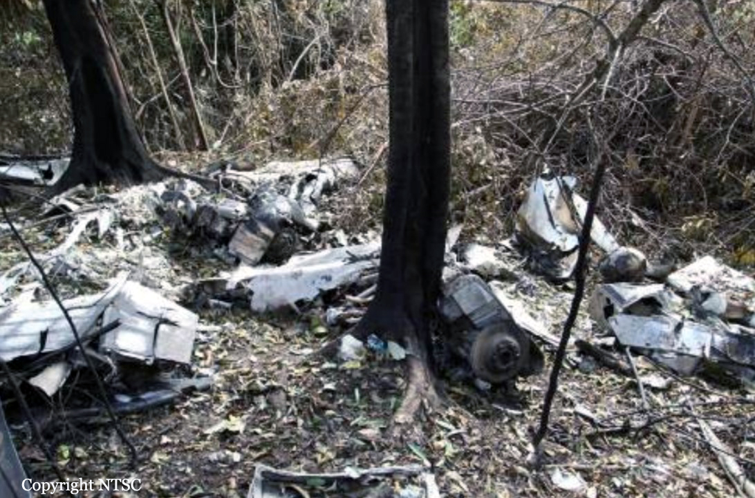
On 19 January 2014, a PA-31-350 Piper Chieftain, registered PK-IWT, was being operated by PT. Intan Angkasa Air Service, on positioning flight from Sentani Airport, Jayapura with intended destination of Juanda Airport, Surabaya for aircraft maintenance. The positioning flight was planned to transit at Dumatubun Airport Langgur of Tual, Maluku and Haluoleo Airport, Kendari at South East Sulawesi for refuelling. On the first sector, the aircraft departed Sentani Airport at 2351 UTC (0851 WIT) and estimated arrival at Langgur was 0320 UTC. On board on this flight was one pilot, two company engineers and one ground staff. At 0240 UTC the pilot contacted to the Langgur FISO, reported that the aircraft position was 85 Nm to Langgur Airport at altitude 10,000 feet and requested weather information. Langgur FISO acknowledged and informed that the weather was rain and thunderstorm and the runway in used was 09. When the aircraft passing 5,000 feet, the pilot contacted the Langgur FISO and reported that the aircraft position was 50 Nm from langgur and informed the estimated time of arrival was 0320 UTC. The Langgur FISO acknowledged and advised the pilot to contact when the aircraft was at long final runway 09. At 0318 UTC, the pilot contacted Langgur FISO, reported the position was 25 Nm to Langgur at altitude of 2,500 feet and requested to use runway 27. The Langgur FISO advised the pilot to contact on final runway 27. At 0325 UTC, Langgur FISO contacted the pilot with no reply. At 0340 UTC, Langgur FISO received information from local people that the aircraft had crashed. The aircraft was found at approximately 1.6 Nm north east of Langgur Airport at coordinate 5° 38’ 30.40” S; 132° 45’ 21.57” E. All occupants fatally injured and the aircraft destroyed by impact force and post impact fire. The aircraft was destroyed by impact forces and post impact fire, several parts of the remaining wreckage such as cockpit could not be examined due to the level of damage. The aircraft was not equipped with flight recorders and the communication between ATC and the pilot was not recorded. No eye witness saw the aircraft prior to impact. Information available for the investigation was limited. The analysis utilizes available information mainly on the wreckage information including the information of the wings, engines and propellers.
Probable cause:
The investigation concluded that the left engine most likely failed during approach and the propeller did not set to feather resulted in significant asymmetric forces. The asymmetric forces created yaw and roll tendency and the aircraft became uncontrolled, subsequently led the aircraft to impact to the terrain.
Final Report:

Crash of a Piper PA-31-350 Navajo Chieftain near Bontang: 4 killed

Date & Time: Aug 24, 2012 at 0810 LT
Operator:
Registration:
PK-IWH
Flight Phase:
Survivors:
No
Schedule:
Samarinda - Bontang
MSN:
31-7852065
YOM:
1978
Country:
Region:
Crew on board:
1
Crew fatalities:
Pax on board:
3
Pax fatalities:
Other fatalities:
Total fatalities:
4
Captain / Total flying hours:
17547
Captain / Total hours on type:
4250.00
Aircraft flight hours:
16743
Aircraft flight cycles:
14830
Circumstances:
On 24 August 2012, a Piper Chieftain PA-31-350 aircraft, registered PK-IWH, was being operated by PT. Intan Angkasa Airservice to conduct an aerial survey (aero magnetic) flight at a survey area located north of Bontang, East Kalimantan. There were 4 persons on board; one pilot, one security officer and two surveyors. Based on the flight plan submitted by the Pilot in Command (PIC) to the Briefing Office, the flight was planned with an altitude of 3,000 feet AMSL en-route and 500 feet AGL while surveying the area. The fuel endurance was for 6 hours flight time and the aircraft equipped with an Emergency Locator Transmitter (ELT). The aircraft departed from Temindung Airport (WALS), Samarinda at 0751 local time (LT - 2351 UTC). At 0004 UTC, the pilot informed to the Temindung Control Tower controller (Temindung Tower) that the aircraft was abeam Tanjung Santan descending from 3,000 feet and established contact with Bontang Info officer (Bontang Info). At 0005 UTC, the pilot informed the Bontang Info that the aircraft altitude was 300 feet and estimated over Bontang at 0011 UTC. Bontang info acknowledged this transmission and advised the pilot to report when the flight left the Bontang Area. At 0010 UTC, the SureTrack (flight following system) stopped receiving data from the aircraft. The last recorded information was an aircraft speed of 138 knots, heading 352°, latitude 0°8’33” N and longitude 117°12’54” E. At 0600 UTC, the engineer of the PK-IWH aircraft asked the Temindung Tower about the flight as the fuel endurance had been exceeded. The Temindung Tower contacted Bontang Info to get information about the aircraft. After receiving the request, Bontang Info tried to contact the pilot twice and there was no reply. Bontang Info also contacted the Tanjung Bara Airstrip to request information about the aircraft but there was no information. The Temindung Tower reported that:
• at 0610 UTC declared INCERFA (Uncertainty phase);
• at 0630 UTC declared ALERFA (Alert phase);
• at 0700 UTC declared DETRESFA (Distress phase).
At 0730 UTC, the search and rescue team was assembled; the team consisted of the Temindung Airport Authority, National Search and Rescue, Indonesian Police, Army and Airforce. The search operation was conducted via ground and air using three helicopters. On 26 August 2012 at 0850 UTC, the aircraft wreckage was located by a ground search team on a ridge of Mayang Hill, Bontang at approximately 1,200 feet AMSL at coordinates 00°12’34.3”N, 117°16’57.3”E, 12 NM from Bontang Aerodrome on bearing of 294°. The accident site was within the planned aircraft survey area. All occupants were fatally injured and the aircraft was destroyed by impact force and post impact fire.
Probable cause:
The accident was typical of a Controlled Flight into Terrain (CFIT). Low altitude VFR flying in a low visibility environment limited the pilot’s visibility and increased the probability of impact with terrain.
Final Report:

Crash of a Piper PA-31-350 Navajo Chieftain in Papua: 2 killed

Date & Time: Nov 19, 1994
Operator:
Registration:
PK-IWC
Flight Phase:
Flight Type:
Survivors:
No
Site:
Schedule:
Jayapura - Oksibil
Country:
Region:
Crew on board:
2
Crew fatalities:
Pax on board:
0
Pax fatalities:
Other fatalities:
Total fatalities:
2
Circumstances:
The crew departed Jayapura-Sentani Airport on a cargo flight to Oksibil. En route, the twin engine aircraft disappeared, maybe in a mountainous area located north of Oksibil. The wreckage was never found.