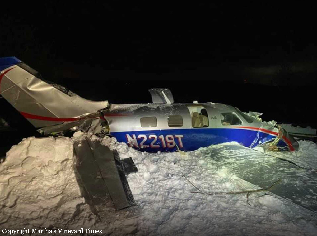
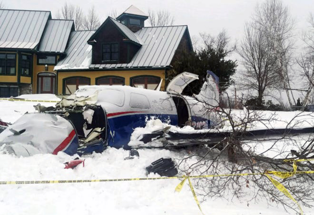
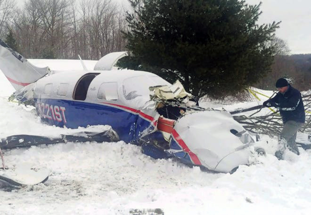
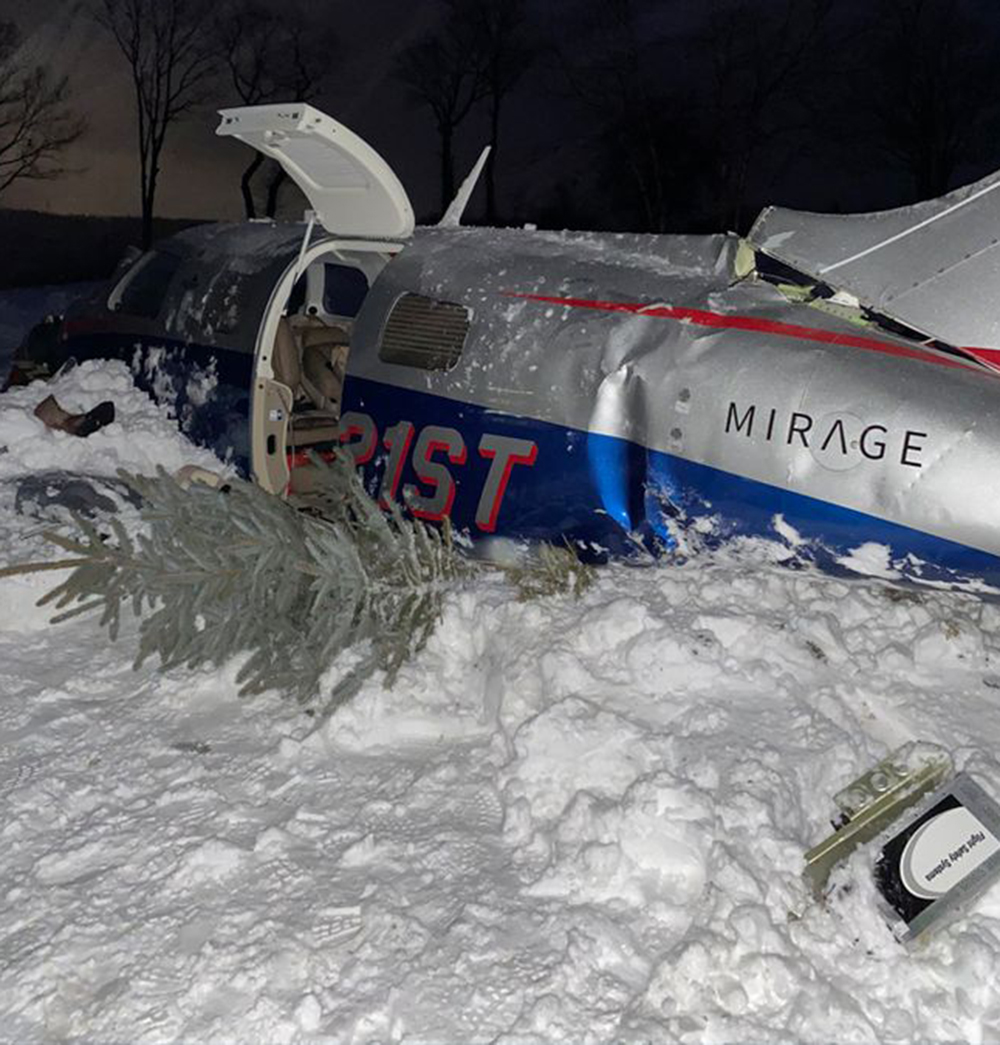
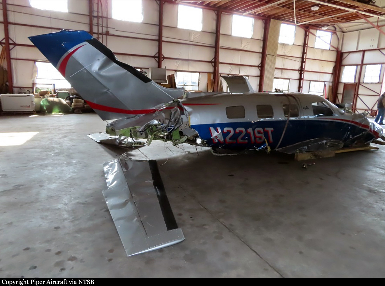
Crash of a Piper PA-46-350P Malibu Mirage in Worcester

Date & Time: Feb 2, 2021 at 1655 LT
Registration:
N221ST
Flight Type:
Survivors:
Yes
Schedule:
Martha’s Vineyard – Worcester
MSN:
46-36651
YOM:
2014
Crew on board:
1
Crew fatalities:
Pax on board:
2
Pax fatalities:
Other fatalities:
Total fatalities:
0
Circumstances:
The pilot reported that, while descending through clouds and beginning the instrument approach, some ice accumulated on the wings and he actuated the deice boots twice. The pilot saw the deice boots functioning normally on the wings and could not see the tail; however, the elevator began to shake, and he lost elevator control. The pilot applied forward pressure on the yoke and had to trim nose-down to avoid a stall. There were no cockpit caution indications and the pilot had disengaged the autopilot before descent. The airplane descended through the clouds and impacted a tree before coming to rest upright in a grass area. Postaccident examination of the wreckage, including component testing of the deice system, did not reveal any preimpact mechanical malfunctions. The flap jackscrew position suggested that the flaps were likely in transit between 0° and 10° flap extension at the time of impact. Review of radar data revealed that, during the 2 minutes before the accident, the airplane’s groundspeed averaged about 82 knots; or an approximate average airspeed of 94 knots when accounting for the winds aloft. Current weather observations and forecast weather products indicated that the airplane was likely operating in an area where moderate and potentially greater structural icing conditions prevailed, and where there was the potential for the presence of supercooled liquid droplets. Review of the pilot operating handbook for the airplane revealed that the minimum speed for flight in icing conditions was 130 knots indicated airspeed. It is likely that the pilot’s failure to maintain an appropriate speed for flight in icing conditions resulted in insufficient airflow over the ice contaminated elevator and the subsequent loss of elevator control.
Probable cause:
The pilot’s failure to maintain the minimum airspeed for flight in icing conditions, which resulted in a loss of elevator control during approach due to ice accumulation.
Final Report:

Crash of a Cessna 402C II in Martha's Vineyard

Date & Time: Jan 30, 2001 at 1835 LT
Type of aircraft:
Operator:
Registration:
N6837Y
Flight Type:
Survivors:
Yes
Schedule:
Providence – Martha’s Vineyard
MSN:
402C-0467
YOM:
1981
Flight number:
9K415
Crew on board:
2
Crew fatalities:
Pax on board:
0
Pax fatalities:
Other fatalities:
Total fatalities:
0
Captain / Total flying hours:
1668
Captain / Total hours on type:
348.00
Aircraft flight hours:
19131
Circumstances:
The pilot departed on a scheduled flight conducted under night instrument meteorological conditions. Arriving in the area of the destination airport, the weather was reported as, winds from 220 degrees at 18 knots, gusts to 25 knots; 1/2 statute miles of visibility and haze; vertical visibility of 100 feet. The pilot was vectored and cleared for the ILS 24 approach. As the airplane crossed the glideslope, the pilot observed that the "ride" became increasingly bumpy and turbulent, with a strong wind component from the right. The approach lights came into view as the airplane neared the runway, but soon disappeared due to the low visibility. The pilot executed a missed approach, and as full power was applied, the airplane began to move laterally to the left. During the missed approach, a "thunk" was heard on the left side of the fuselage, and the airplane descended into the trees. The airplane came to rest in a wooded area about 1/4 mile from the Runway 24 threshold, about 1,000 feet to the left of the extended centerline. Review of the approach plate for the ILS 24 approach revealed that the glide slope altitude at the final approach fix for the non-precision approach, which was located about 4 miles from the approach end of the runway, was 1,407 feet. The glide slope altitude at the middle marker, which was located about 0.6 miles from the approach end of the runway, was 299 feet. Review of radar data revealed that the airplane intercepted the glideslope about 4 miles from the threshold of runway 24. In the following 2 minutes, 30 seconds, the airplane deviated below and returned to the glideslope centerline approximately 4 times, with a maximum deviation of 2-dots below the glideslope centerline. About 1-mile from the runway, the airplane began a trend downward from the glideslope centerline, descending below the 2- dot low deviation line of the glideslope to an altitude of about 300 feet, when the last radar hit was recorded. During the approach, the airplane's ground speed varied between 50 and 125 knots. According to the Aeronautical Information Manual chapter on Navigation Aids, Instrument Landing System (ILS), it stated that "Make every effort to remain on the indicated glide path." It also cautioned the pilot to, "Avoid flying below the glide path to assure obstacle/terrain clearance is maintained."
Probable cause:
The pilot's failure to maintain a stabilized approach with an adequate vertical and lateral track. Also causal was his failure to maintain obstacle clearance.
Final Report:

Crash of a Mitsubishi MU-2B-26A Marquise in Martha’s Vineyard: 4 killed

Date & Time: Oct 6, 2000 at 2158 LT
Type of aircraft:
Registration:
N60BT
Flight Type:
Survivors:
No
Schedule:
Trenton – Martha’s Vineyard
MSN:
358
YOM:
1977
Crew on board:
1
Crew fatalities:
Pax on board:
3
Pax fatalities:
Other fatalities:
Total fatalities:
4
Captain / Total flying hours:
1946
Captain / Total hours on type:
253.00
Aircraft flight hours:
5400
Circumstances:
The pilot departed on a night cross-country flight without obtaining a weather briefing or flight plan. Arriving in the area of the destination airport, the weather was reported as, 2 statute miles of visibility and mist; overcast cloud layer at 100 feet. The pilot requested an instrument flight rules clearance from the approach controller, and was vectored and cleared for the ILS 24 approach. The clearance included an altitude restriction of 1,500 feet msl, until the airplane was established on the localizer. As the pilot contacted the control tower, the tower controller issued a low altitude alert to the pilot. The pilot replied that he was climbing and the tower controller cleared the pilot to land, which the pilot acknowledged. No further pertinent radio transmissions were received from the airplane. The airplane came to rest in a wooded area about 3/4-mile from the runway threshold, and about 50 feet right of the extended centerline. Review of the approach plate for the ILS 24 approach revealed that the minimum glide slope intercept altitude at the beginning of the final approach segment on the precision approach was 1,500 feet. The glide slope altitude at the final approach fix for the non-precision approach, which was located about 4 miles from the approach end of the runway, was 1,407 feet. The glide slope altitude at the middle marker, which was located about 0.6 miles from the approach end of the runway, was 299 feet. Review of radar data revealed that the airplane was observed at 700 feet, about 4 miles from the airport, and at 300 feet, about 1.5 miles from the airport. The pilot had accumulated about 1,946 hours of total flight experience, with about 252 hours in make and model. The pilot had attended initial and recurrent training for the make and model airplane; however, did not complete the training. The pilot, aged 61, was Charles B. Yates, member of the New Jersey Senate, who was flying to Martha's Vineyard with his wife and two of his three children.
Probable cause:
The pilot's failure to follow instrument flight procedures resulting in a collision with a tree. A factor related to the accident was the low cloud ceiling.
Final Report:

Crash of a Douglas C-53-DO in New Bedford: 12 killed

Date & Time: Sep 15, 1957 at 2046 LT
Operator:
Registration:
N34417
Survivors:
Yes
Schedule:
Boston – Hyannis – Martha’s Vineyard – New Bedford – New York
MSN:
7337
YOM:
1942
Flight number:
NE285
Crew on board:
3
Crew fatalities:
Pax on board:
21
Pax fatalities:
Other fatalities:
Total fatalities:
12
Captain / Total flying hours:
7079
Captain / Total hours on type:
4348.00
Copilot / Total flying hours:
2097
Copilot / Total hours on type:
1522
Aircraft flight hours:
35685
Circumstances:
Northeast Airlines Flight 285 is a scheduled passenger operation originating at Boston, Massachusetts, and terminating at New York, New York, with intermediate stops serving Hyannis, Nantucket, Martha's Vineyard, and New Bedford, Massachusetts. On September 15, 1957, the flight originated on schedule, its crew consisting of Captain Vincent L. Pitts, Reserve Captain Roger W. Sweetland, serving as copilot, and Stewardess Nancy J. Lehan. Flight 285 was routine until it reached Martha's Vineyard where it landed at 2007 following a missed approach in poor weather conditions. The flight departed Martha's Vineyard for New Bedford at 2019, about 50 minutes behind schedule, the result of the missed approach, IFR delays, and accumulated minor delays. The flight to New Bedford was in and on top of Instrument weather conditions and was conducted according to an IFR (Instrument Flight Rules) flight plan. The clearance given the flight by ARTC (Air Route Traffic Control) through company radio was as follows. "ATC clears Northeast 285 to the New Bedford middle marker, via direct Otis, Red 94, to maintain 4,000, to make climb to 2,500 at the Martha's Vineyard radio beacon before proceeding on course. Report on course and report the Otis radio beacon." At departure there was sufficient fuel for the flight to New Bedford, and, if necessary to the designated alternate airport, Boston, with the required reserve upon arrival there. Also, at this time, according to the company load manifest, the aircraft was loaded to a gross weight of 22,443 pounds, well under the maximum allowable of 25,346 pounds. The load was distributed within the center of gravity limitations of the aircraft. At 2024 the flight reported to the company radio at Martha's Vineyard that it was over the Martha's Vineyard radio beacon, "2,500 feet on course." At 2029 it again contacted the company at Martha's Vineyard and reported it was then over Otis at 4,000 feet. A few minutes later Flight 285 contacted the New Bedford taper controller and informed him it was unable to give the Otis report to the company at Boston. The controller took the progress report and requested the flight to contact Providence approach control (Providence controls IFR flights in the New Bedford area). The flight immediately contacted Providence approach control and was cleared to maintain 4,000 feet to the compass locater at the New Bedford middle marker and to report over the marker. This was acknowledged. Immediately thereafter Providence cleared Flight 285 for an approach to the New Bedford Airport and requested it to report leaving 4,000 feet and then switch to the New Bedford tower. At 2036 the flight reported leaving 4,000 feet. Flight 285 then contacted the New Bedford tower operator and thereafter, at 2038, according to the controller, stated it was starting an ILS approach. The controller gave the flight the latest weather as follows: Indefinite 200, obscuration; visibility one mile; fog; wind southeast 3; altimeter 30.02. He also cleared the flight to land, ILS approach, straight in to runway 5, and requested that it call the tower when inbound at the outer marker. Following this clearance the captain of another Northeast flight, 275, which had shortly before, at 2031, taken off from runway 23, the reciprocal of 5, gave Flight 285 the following information. "It'll be tight." Flight 285 reported that it had completed the procedure turn and was inbound over the outer marker. The controller acknowledged this report which was the last communication with the flight. He logged the report at 2046, shortly after it was received. The airplane clip trees and crashed in a dense wooded area located 4,000 feet short of runway 05 threshold. Both pilots and ten passengers were killed while 12 other occupants were injured. The aircraft was destroyed.
Probable cause:
The Board determines that the probable cause of this accident ins that the pilot, attempted to make a visual approach by descending prematurely in the approach area without adherence to the prescribed ILS approach procedure which was dictated by existing weather conditions. The following findings were reported:
- Flight to the New Bedford area was made in and on top of instrument weather conditions in accordance with an instrument flight rules flight plan,
- Flight 285 reached the New Bedford area and was cleared for an ILS approach,
- Weather conditions at the airport and the surrounding area clearly dictated an ILS approach,
- Airborne and ground equipment necessary to the ILS approach was functioning normally,
- Flight 285 descended prematurely in the approach area without conformity to the ILS procedure,
- Flight 285 descended to a low and unsafe altitude in an attempt to approach the airport visually, assisted by directional instruments,
- The flight did not conform to the ILS glide path,
- From low altitude a descent occurred which was not recognized by the pilots in time for corrective action to be effective,
- The trees struck were located 165 feet to the right of the localizer centerline, nearly 189 feet below the glide path centerline, and about 4,000 feet short of the runway threshold,
- There was no evidence of malfunction of the aircraft, its systems, or powerplants.
Final Report: