Zone

Crash of a Hawker 900XP near Bitter Creek: 2 killed

Date & Time: Feb 7, 2024 at 1047 LT
Type of aircraft:
Operator:
Registration:
N900VA
Flight Phase:
Flight Type:
Survivors:
No
Schedule:
Grand Junction - Tacoma
MSN:
HA-0020
YOM:
2007
Crew on board:
2
Crew fatalities:
Pax on board:
0
Pax fatalities:
Other fatalities:
Total fatalities:
2
Circumstances:
The airplane departed Grand Junction Airport at 1037LT on a positioning flight to Tacoma, carrying a crew of two. About 10 minutes later, it entered an uncontrolled descent and crashed in a uninhabited area located near the Bitter Creek River, eastern Utah, near the border with Colorado. The airplane was destroyed by impact forces and a post crash fire and the wreckage was found about 17 km west northwest from the Mack-Mesa Airport located in Colorado. Both occupants were killed.

Crash of a Cessna 421C Golden Eagle III in Tacoma: 1 killed

Date & Time: Jan 25, 2006 at 1344 LT
Registration:
N69KM
Survivors:
No
Schedule:
Scottsdale - Tacoma
MSN:
421C-0440
YOM:
1977
Crew on board:
1
Crew fatalities:
Pax on board:
0
Pax fatalities:
Other fatalities:
Total fatalities:
1
Captain / Total flying hours:
400
Aircraft flight hours:
5363
Circumstances:
During a cross country flight, the pilot was informed by air traffic control that adverse weather was along his route of flight for terrain obscurement in clouds, precipitation, fog or mist. Turbulence was reported below 12,000 feet and occasional moderate rime or mixed icing was reported from the freezing level to 14,000 feet. Further along the route, the pilot reported to another controller that he was at 13,000 feet and descending. The controller inquired if the pilot was aware of the center weather advisory and the reports of severe rime ice in the direction that he was heading. The pilot acknowledged the controller by reporting that he was aware of the weather and that the aircraft was "equipped." The controller continued to inform the pilot of pilot reports from commercial aircraft flight crews of the reports of icing conditions, however, the pilot continued on his routing and again reported that the aircraft was "equipped." During the last transmissions from the pilot, he reported that he was "turning on (de-ice) equipment now." The controller recommended to the pilot to stay clear of the clouds. The pilot responded, "roger." The controller then asked the pilot if he was "going to orbit there for awhile." The pilot responded, "yes," followed by a partially unintelligible transmission of "getting some weather here." The pilot's last transmissions were "Ah, I'm in a little trouble," followed by "Ah, standby 9KM." Radar tracking indicated that the aircraft had been cruising at 16,500 feet before starting a gradual descent. The aircraft descended to 12,700 feet and it began a turn to the right. During this turn, the aircraft's altitude changed rapidly beginning with an increase, followed by a rapid loss of altitude from 8,000 feet per minute descent to 10,600 feet per minute descent before radar contact was lost. The aircraft was found 6 months later in an area of mountainous terrain. On site evidence indicated that the aircraft collided with trees and terrain in a nose low attitude with the majority of the wreckage contained in a large deep crater.
Probable cause:
The pilot's failure to maintain aircraft control while maneuvering. Icing conditions, clouds and the pilot's continued flight into known adverse weather were factors.
Final Report:

Crash of a Douglas C-47B-15-DK in Gustavus: 4 killed

Date & Time: Nov 23, 1957 at 2000 LT
Operator:
Registration:
43-49403
Flight Type:
Survivors:
Yes
Schedule:
San Francisco – McChord – Annette Island – Anchorage
MSN:
15219/26664
YOM:
1944
Location:
Crew on board:
4
Crew fatalities:
Pax on board:
7
Pax fatalities:
Other fatalities:
Total fatalities:
4
Circumstances:
The morning of the crash, the crew departed from McChord Air Force Base near Tacoma, Washington, where they had picked up “hitchhiker” Corporal Timmons and then flew northward. Radio difficulties developed necessitating a return to McChord. Soon remedied, they departed once more for their first fuel stop, Annette Island, near Ketchikan, Alaska, enroute to their final destination, Anchorage, Alaska. High winds and severe turbulence prevented them from landing at Annette Island. The crew was given a choice – either return to a Canadian airport behind them or proceed north to Gustavus where runway lights and equipment for instrument landings offered better facilities for night landings than even Juneau in those days. The weather in Gustavus was reported as “clear and no winds” to “very slight winds”. The crew elected to go to Gustavus. Although the California pilot was well-trained in multi-engine instrument approaches, he was relatively new to Alaskan conditions. As the plane approached Gustavus, it was dark and beginning to snow. The passengers on the plane realized they had arrived in the Gustavus area, momentarily spotting lights through the dark and snow as they anxiously looked out the windows. The fuel supply was very low, so there were no options of returning to Annette or proceeding to Anchorage. The captain was leery of making the standard instrument approach to Gustavus because it would have required him to fly well beyond the airfield, far out over Glacier Bay with an aircraft that was running precariously low on fuel. On the next attempt – now the third time over the airport area in what the locals described as a snow squall, Mr. Aase reported that, “The pilot was in line for the runway, but got a bit low and the right wing caught a tall tree that made the aircraft start to spin and (it) nosed into the ground. “The front of the plane was badly damaged. At the same time the plane was twisting, the tail slowly lowered into the trees which cushioned it. It set down gently into the trees so that the fuselage from the wall aft was just about in perfect condition. So apparently, while attempting to keep the airfield in sight, he elected to circle and make a “short” visual approach to the runway. All four crew members were killed and the seven passengers were injured.
Crew:
Cpt Robert E. Kafader,
1st Lt Dennis V. Stamey,
S/Sgt Floyd S. Porter,
S/Sgt David A. Dial.
Passengers:
Lloyd Timmons,
2nd Lt Harry S. Aase,
Cpt Robert D. Ellis,
W/O Richard J. Mueller,
M/Sgt James E. O’Rourke,
1st Lt Wallace J. Harrison,
2nd Lt William W. Caldwell.
Source and text by Rita Wilson via
http://www.gustavushistory.org/articles/view.aspx?id=10000

Crash of a Douglas C-54A-1-DO Skymaster in Tacoma: 9 killed

Date & Time: Nov 30, 1947 at 1425 LT
Type of aircraft:
Operator:
Registration:
NC91009
Survivors:
Yes
Schedule:
Anchorage – Yakutat – Seattle
MSN:
7453
YOM:
1943
Flight number:
AS009
Crew on board:
3
Crew fatalities:
Pax on board:
25
Pax fatalities:
Other fatalities:
Total fatalities:
9
Captain / Total flying hours:
8352
Captain / Total hours on type:
738.00
Copilot / Total flying hours:
3220
Copilot / Total hours on type:
1483
Aircraft flight hours:
5548
Circumstances:
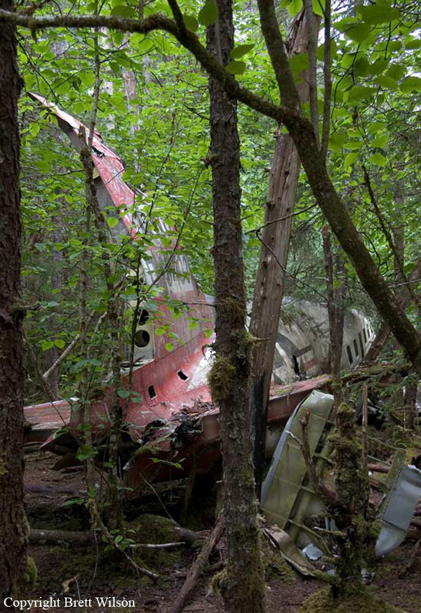
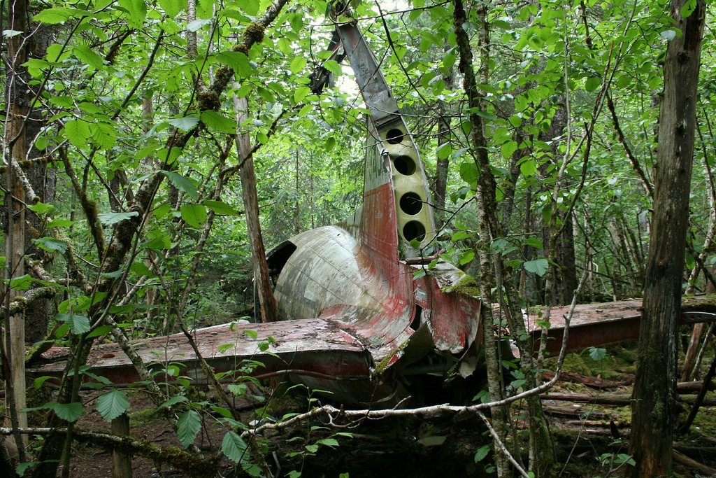
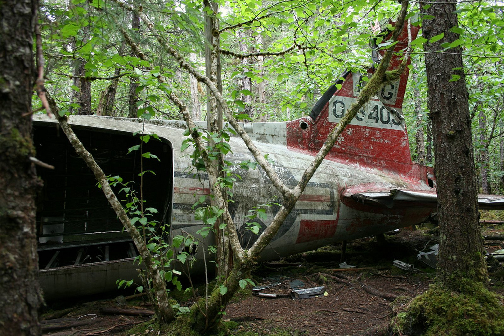
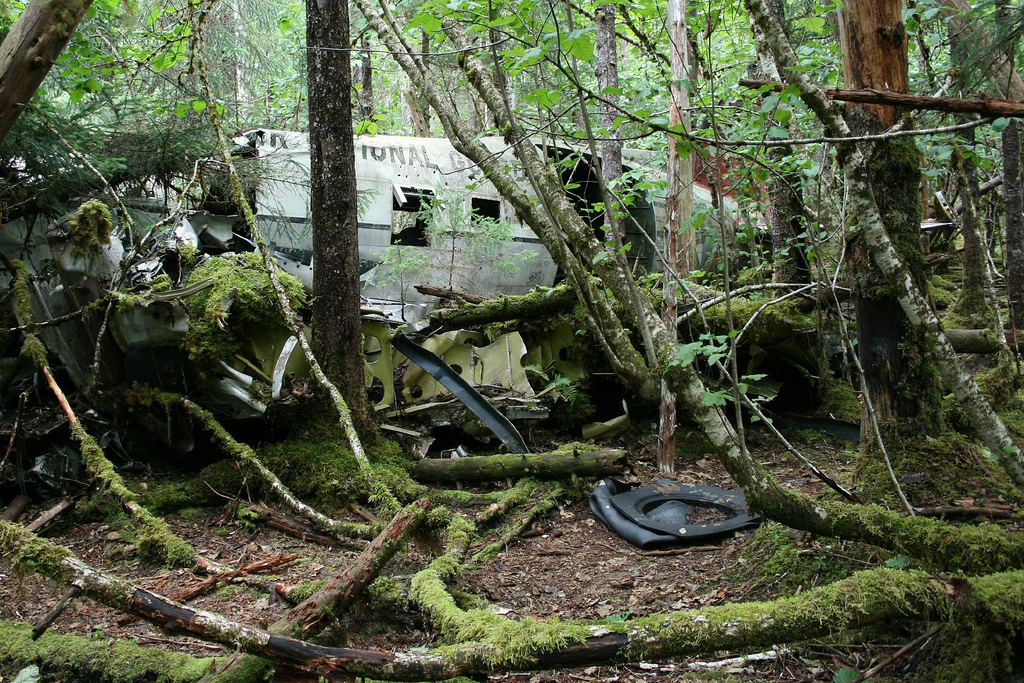
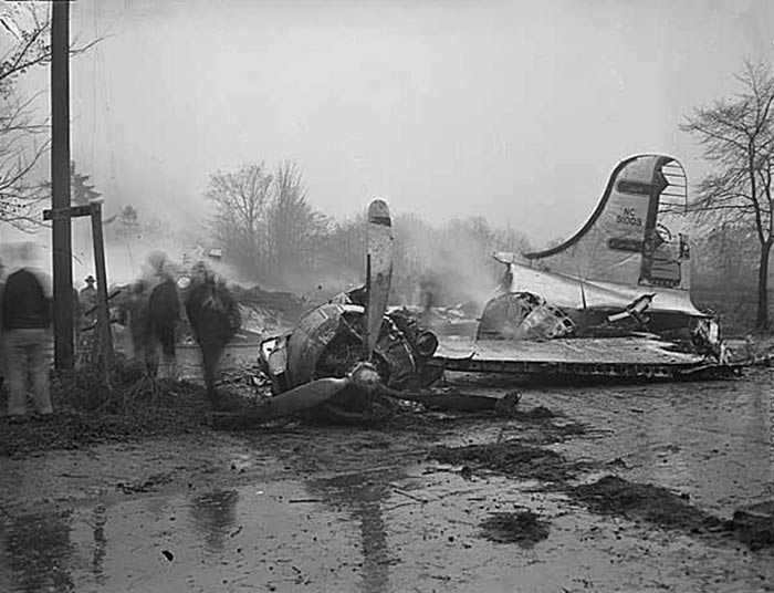
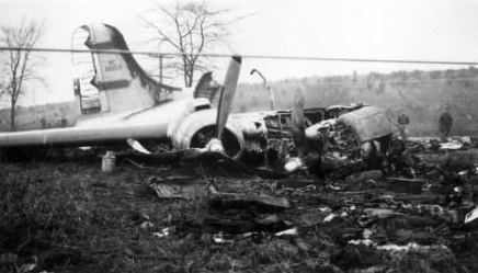
The flight arrived over the Seattle radio range station at 3,000 feet on its initial approach to the Boeing Airport at 1357. Shortly before Captain Farris had reported to Seattle Radio that he had 2 rough engines, but he did not declare an emergency. The condition of engine roughness is discussed below. Weather at Boeing Field, Seattle, Washington, was reported to be ceiling indefinite 500 feet visibility one mile. An instrument approach for landing at Boeing Field was made, but not completed because of the low ceiling and visibility, so the flight returned to an altitude of 1,500 feet on the northwest course of the Seattle radio range. During this time Copilot Whitting remained in the left seat and flew the airplane. The second instrument approach was made for a landing at the Seattle-Tacoma Airport, sometimes referred to as the Bow Lake Airport, which is located 4 miles south of the Seattle radio range station. The airplane was flown inbound on the northwest course of the range. Then, after passing over the range station at 1,500 feet, a heading of 193 degrees toward the airport was flown, and a descent made for landing. The aircraft was first observed at the Seattle-Tacoma Airport when approximately 500 feet above the approach and of Runway 20, 5,611 feet long, at which time it was flying at an angel to the left of the runway. An "S" maneuver and rapid decent were made. A right turn was entered and held until the airplane was again over Runway 20, then it turned left. When the airplane first made contact with the runway it was in the left turn, and the left wing was so low that those who observed the landing thought that it would strike the ground. The first point of touchdown was made 2,748 feet beyond the approach end of the runway. The airplane progressed over the remaining distance of the runway without apparent deceleration. Captain Farris, who had taken over the controls of the airplane when it was in the left turn, stated that he allowed the airplane to slow down of its run accord to 50 or 60 miles per hour before applying brakes, and that he released the emergency air bottle 1,000 feet from the end of the runway. Before passing over the end of the runway an attempt was made to groundloop the airplane to the left by applying power to engine 4. Nevertheless, the airplane traveled almost straight ahead. It went off the end of the runway, crossed 229 feet of wet ground, and then rolled down a 24-foot embankment. At the bottom of the embankment it struck a ditch which sheared off the left lending gear and the left wing. The aircraft continued on to the intersection of the Des Moines Highway and South 188th Street where it collided with a moving automobile. Spilled gasoline was ignited, and the wreckage was enveloped in flames. The Weather Bureau at tie Seattle-Tacoma Airport made an observation immediately following the crash and reported an indefinite ceilings, 400-foot overcast, visibility variable one-half to one mile, and light rain and fog.
Probable cause:
The Board determines that the probable cause of this accident was the landing of the airplane too far from the approach end of a wet runway and at a speed too great to accomplish a full stop on the runway.
The following factors were considered as contributory:
- The flight arrived over the approach end of the intended runway too high and non properly lined up for a normal landing,
- First touchdown was made at a point 2,748 feet from the approach end of Runway 20, 5,611 feet long, at which time the airplane was in a left bark steep enough to place the left wing tip almost on the ground,
- The left outboard main landing gear tire marked the runway for a distance of 105 feet after which the airplane flow 60 feet. Seven hundred and eleven feet of runway were traversed from the first point of touchdown before all 4 main landing gear wheels were solidly on the runway.
Final Report: