code

VT

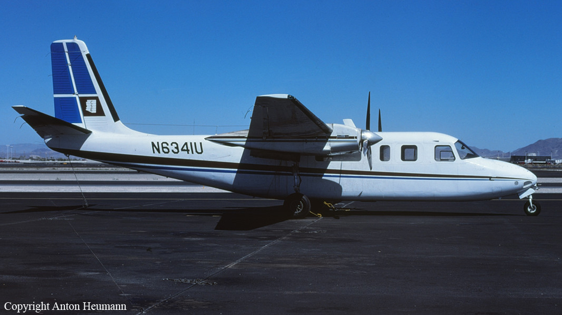
Crash of a Piper PA-61 Aerostar (Ted Smith 601) in West Dover: 1 killed

Date & Time: Dec 2, 2006 at 1245 LT
Registration:
N9797Q
Flight Type:
Survivors:
No
Schedule:
White Plains – West Dover
MSN:
61-0432-160
YOM:
1977
Crew on board:
1
Crew fatalities:
Pax on board:
0
Pax fatalities:
Other fatalities:
Total fatalities:
1
Captain / Total flying hours:
14000
Captain / Total hours on type:
2600.00
Aircraft flight hours:
2953
Circumstances:
On the day of the accident, the pilot was returning to his home airport, after dropping off friends at a different airport. No weather briefing or flight plan was filed with Flight Service for either flight. A witness and radar data depicted the accident airplane on a straight-in approach for runway 1, in a landing configuration, at a ground speed of approximately 120 knots. The last radar target was recorded about 1/4 mile from the runway threshold, at an altitude of approximately 150 feet agl. The wreckage was later found about 1/2 mile east of the runway threshold. Review of weather information revealed general VFR conditions along the route of flight, and at reporting stations near the accident site. Gusty winds, low-level wind shear, and moderate to severe turbulence also prevailed at the time of the accident. In addition, weather radar depicted scattered light snow showers in the vicinity of the accident site, and possibly a snow squall. Examination of the wreckage did not reveal any preimpact mechanical malfunctions. The pilot had a total flight experience of 14,000 hours, with 8,500 hours in multiengine airplanes, including 2,600 hours in the same make and model as the accident airplane. He also had 4,100 hours of instrument flight experience.
Probable cause:
A loss of control during approach for undetermined reasons, which resulted in a collision with trees.
Final Report:

Crash of an Embraer EMB-110P1 Bandeirante in Pownal: 1 killed

Date & Time: Aug 4, 2006 at 0918 LT
Operator:
Registration:
N59BA
Flight Type:
Survivors:
No
Site:
Schedule:
Binghamton - Bennington
MSN:
110-396
YOM:
1982
Flight number:
BEN059
Location:
Crew on board:
1
Crew fatalities:
Pax on board:
0
Pax fatalities:
Other fatalities:
Total fatalities:
1
Captain / Total flying hours:
2877
Captain / Total hours on type:
47.00
Aircraft flight hours:
40043
Circumstances:
The airport's instrument approach procedures included a very high frequency, omnidirectional range (VOR) approach, and a global positioning system (GPS) approach that was not an overlay. The VOR approach procedure included an inbound course to the VOR, and after passage, a descent along the same course to a missed approach point. The missed approach point was defined as 6 nautical miles beyond the VOR, as well as by timing. The pilot twice attempted the VOR approach in instrument meteorological conditions. He flew the first approach to the missed approach point, initiated a missed approach, contacted the controller, and requested a second VOR approach. He then received vectors to rejoin the approach course inbound to the VOR. The airplane subsequently passed over the VOR, on course, about 100 feet above the minimum altitude. However, instead of descending as described in the procedure, the airplane maintained that altitude until reaching the airport, then began a descent. The airplane continued to travel outbound along the same approach course until it impacted rising terrain about 6.5 miles beyond the airport. There was no dedicated distance measuring equipment (DME) onboard the airplane. Instead, distance was determined by the use of an instrument flight rules (IFR)-approved GPS unit. Due to the non-storage capability of the unit, historical waypoint selection could not be determined. The pilot could have selected the airport as a "direct to" waypoint, or, if he had entered flight plan waypoints, the unit would have sequenced from the VOR to the airport during the first approach. In either case, unless the pilot reprogrammed the unit, the last waypoint entered would have remained at the airport, rather than the VOR. The pilot then most likely mistook the airport position for the VOR position, and displaced the beginning of the descent by 6 nautical miles. Also noted, was that once the airplane passed over the VOR en route to the airport, the HSI would have indicated a change of "to" to "from". There were no medical anomalies noted with the pilot and no mechanical anomalies noted with the airplane.
Probable cause:
The pilot's misinterpretation of the airplane's position relative to the final approach fix, which resulted in the displacement of the descent profile by 6 nautical miles and the subsequent controlled flight into rising terrain. Contributing to the accident were the low clouds.
Final Report:

Crash of a Piper PA-61 Aerostar (Ted Smith 601) in Chittenden: 2 killed

Date & Time: Jan 25, 2002 at 1710 LT
Registration:
N104CS
Flight Phase:
Flight Type:
Survivors:
No
Site:
Schedule:
Johnstown – Rutland
MSN:
61-0404-141
YOM:
1977
Crew on board:
1
Crew fatalities:
Pax on board:
1
Pax fatalities:
Other fatalities:
Total fatalities:
2
Captain / Total flying hours:
1000
Captain / Total hours on type:
250.00
Aircraft flight hours:
1780
Circumstances:
The airplane collided with mountainous terrain during approach to the destination airport. While approaching the airport, the pilot requested vectors for a localizer approach to runway 19. Due to traffic, air traffic control (ATC) issued the pilot a holding clearance. The airplane was approaching the holding fix about 8,000 feet, when the pilot advised ATC that the airplane was picking up a little ice. ATC initially offered an amended clearance of 9,000 feet, but the pilot declined. Subsequently, he accepted the clearance and climbed back to 9,000 feet. ATC then told the pilot that after one more airplane had landed, he would be issued an approach clearance. The airplane was about 9,200 feet when the pilot replied "thank you." Review of radar data revealed that the accident airplane made one complete 360-degree turn, and one 270-degree turn on the non-holding side of the published holding pattern. During the two turns, the airplane descended to approximately 8,400 feet, climbed to 8,900 feet, then descended again to 8,300 feet. The two turns were tighter than the expected standard 2-minute turns in a holding pattern, with radii ranging from 0.3 to 0.4 nautical miles and 0.1 to 0.2 nautical miles respectively. Following the two holding turns, no more radio transmissions or radar returns were received by ATC. Examination of the wreckage did not reveal any preimpact mechanical malfunctions. Another pilot flying in the area reported moderate rime ice at 8,000 feet, but added that he climbed out of the ice and was between cloud layers at 9,000 to 10,000 feet.
Probable cause:
The pilot's failure to maintain aircraft control while holding.
Final Report:

Crash of a Piper PA-61P Aerostar (Ted Smith 601) in Burlington

Date & Time: Oct 12, 2000 at 0931 LT
Registration:
C-FAWF
Flight Phase:
Flight Type:
Survivors:
Yes
Schedule:
Burlington – Toronto
MSN:
61-0629-7963287
YOM:
1979
Crew on board:
1
Crew fatalities:
Pax on board:
4
Pax fatalities:
Other fatalities:
Total fatalities:
0
Captain / Total flying hours:
15000
Captain / Total hours on type:
30.00
Circumstances:
The pilot reported that after rotation, he obtained a positive rate of climb. At 110 knots, with the landing gear retracted and the wing flaps at 10 degrees, he noticed a right roll, a drop in climb performance, and a drop of manifold pressure on the right engine to at least 34 inches. The left engine maintained 42 inches. The pilot decided that, due to a "very minimum climb rate, rising terrain ahead, [and] airspeed not increasing," he would land the airplane in a small field about 1/4 mile and 50 degrees to the left. The pilot abruptly lowered the nose of the airplane and raised the flaps to gain airspeed, then landed with a nose-high attitude and the landing gear partially extended. Post-accident examination of the airplane revealed there was vertical compression to the belly area, the fuselage was spilt across the top at the aft end of the cabin, and both wings were damaged, with the left wing buckled downward just inboard of the engine. Examination also revealed that a clamp on the right engine intake manifold was loose. An estimated takeoff weight placed the airplane 74 pounds over the maximum allowed of 6,200 pounds. The type certificate holder estimated that with the airplane at 6,400 pounds, climbing at 110 kts, and with a partial power loss down to 26 inches on one engine, the rate of climb should have been 1,150 fpm with flaps and landing gear up, and 830 fpm with flaps 10 degrees and landing gear down. Higher terrain was to the east, and lower terrain was to the west. Terrain elevation for a straight-out departure was 25 feet above the runway at 0.5 nm, and 70 feet above the runway at 2.8 nm. The pilot reported his total flight experience as 15,000 hours, which included 13,000 hours in multi-engine airplanes, and 30 hours in make and model, all with the preceding 90 days.
Probable cause:
The pilot's improper in-flight decision to perform a precautionary landing, and his failure to maintain airspeed after he experienced a partial loss of power on one engine. A factor was the partial loss of power on one engine due to an induction air leak.
Final Report:

Crash of a Convair CV-580 in Belvidere Centre: 2 killed

Date & Time: Sep 18, 1991 at 2150 LT
Type of aircraft:
Operator:
Registration:
C-FICA
Flight Phase:
Flight Type:
Survivors:
No
Site:
Schedule:
Moncton - Hamilton
MSN:
98
YOM:
1968
Crew on board:
2
Crew fatalities:
Pax on board:
0
Pax fatalities:
Other fatalities:
Total fatalities:
2
Captain / Total flying hours:
10400
Captain / Total hours on type:
1200.00
Aircraft flight hours:
39323
Circumstances:
The airplane was cruising in night instrument meteorological conditions when it entered a left turn and exceeded the design airframe limits. The airplane broke up in the descent due to aerodynamic forces and was destroyed. The outboard wing panels had failed downward and center wing section separated from the fuselage. The horizontal stabilizer and elevators had failed down and aft. The captain was found out of the cockpit with no evidence of him being in the seat at impact a human factors study found the aircraft's last minute of flight matched a profile of a pilot experiencing spatial disorientation. Both pilots were killed.
Probable cause:
Failure of the first officer (co-pilot) to maintain control of the aircraft after becoming spatially disoriented, and his exceeding the design stress limits of the aircraft. Factors related to the accident were: the lack of two pilots in the cockpit, darkness, and instrument meteorological conditions (IMC) at flight altitude.
Final Report:

Crash of a Cessna 208B Grand Caravan in Burlington: 2 killed

Date & Time: Jan 29, 1990 at 2100 LT
Type of aircraft:
Operator:
Registration:
N4688B
Flight Phase:
Flight Type:
Survivors:
No
Schedule:
Burlington - Albany
MSN:
208B-0169
YOM:
1989
Crew on board:
1
Crew fatalities:
Pax on board:
1
Pax fatalities:
Other fatalities:
Total fatalities:
2
Captain / Total flying hours:
3110
Captain / Total hours on type:
270.00
Aircraft flight hours:
371
Circumstances:
The pilot failed to deice the wings prior to the takeoff and overloaded the airplane by 360 lbs structurally and 1,100 lbs for flight in icing conditions. There was moderate snow falling at the time of takeoff. The takeoff roll was described as long and a witness saw the wings rocking from side to side after takeoff. The airplane struck trees one mile off the end of the runway, crashed and burned. Post accident investigation found snow contamination on the top of one wing that did not burn and the top of the horizontal stabilizers and elevators. No discrepancies were found with the engine or airframe. Both occupants were killed.
Probable cause:
The failure of the pilot to de-ice the airplane prior to departure, and his decision to make the takeoff at a weight that exceeded both the maximum structural takeoff weight and the reduced takeoff weight allowed for icing conditions resulting in an inadvertent stall.
Final Report:

Crash of a Rockwell Grand Commander 680FL on Mt Ethan Allen: 1 killed

Date & Time: Aug 8, 1986 at 0800 LT
Registration:
N6341U
Flight Phase:
Flight Type:
Survivors:
No
Site:
Schedule:
Montpelier - Burlington
MSN:
680-1379-47
YOM:
1963
Crew on board:
1
Crew fatalities:
Pax on board:
0
Pax fatalities:
Other fatalities:
Total fatalities:
1
Captain / Total flying hours:
2428
Captain / Total hours on type:
53.00
Aircraft flight hours:
8072
Circumstances:
The pilot was on a VFR flight from Montpelier, VT to Burlington, VT; a distance of about 80 miles. A mountain range is between the two location. Shortly after takeoff the pilot radioed Burlington approach control and requested an IFR clearance to land at Burlington. He reported that he was 10 miles northwest of Montpelier. The pilot was assigned a transponder code. The air traffic controller then noticed that the aircraft was near a mountain at a unverified altitude of 3,500 feet. The controller alerted the pilot that he was 2 miles south of a 4,393 feet high mountain. There was no response from the pilot. The aircraft collided with the east side of Mt Ethan Allen at a height of 3,580 feet. The aircraft was on a northwest heading at impact. VFR conditions of 3,800 feet broken and 4,000 feet scattered existed at the time. The pilot, sole on board, was killed.
Probable cause:
Occurrence #1: in flight collision with terrain/water
Phase of operation: cruise
Findings
1. (c) vfr flight into imc - performed - pilot in command
2. (f) terrain condition - mountainous/hilly
3. (c) clearance - inadequate - pilot in command
4. (f) weather condition - obscuration
Final Report:

Crash of a Learjet 55 Longhorn in Rutland

Date & Time: Aug 6, 1986 at 1455 LT
Type of aircraft:
Registration:
N921FP
Flight Phase:
Survivors:
Yes
Schedule:
Rutland - Teterboro
MSN:
55-103
YOM:
1984
Crew on board:
2
Crew fatalities:
Pax on board:
1
Pax fatalities:
Other fatalities:
Total fatalities:
0
Captain / Total flying hours:
7900
Captain / Total hours on type:
1800.00
Aircraft flight hours:
901
Circumstances:
The Lear 55 taxied out for takeoff and inadvertently attempted a takeoff on the wrong runway. When he realized his mistake, he aborted the takeoff because he knew the runway length was significantly less than his required field length. Insufficient runway also remained for the aborted takeoff and the aircraft ran off the end of the runway and hit a stone wall. The aircraft was destroyed by fire and the copilot received minor injuries while the pilot and the passenger were not injured.
Probable cause:
Occurrence #1: overrun
Phase of operation: takeoff - roll/run
Findings
1. Light condition - daylight
2. (c) wrong runway - selected - pilot in command
3. (f) complacency - pilot in command
4. (c) checklist - not used - pilot in command
5. Aborted takeoff - performed - pilot in command
6. (c) procedures/directives - not followed - pilot in command
----------
Occurrence #2: on ground/water collision with object
Phase of operation: takeoff - roll/run
Findings
7. (f) object - fence
Final Report:

Crash of a Cessna 401A in Dorset: 1 killed

Date & Time: Mar 17, 1985 at 2015 LT
Type of aircraft:
Registration:
N12CQ
Flight Phase:
Survivors:
No
Site:
Schedule:
Caldwell - Rutland
MSN:
401A-0116
YOM:
1969
Location:
Crew on board:
1
Crew fatalities:
Pax on board:
0
Pax fatalities:
Other fatalities:
Total fatalities:
1
Captain / Total flying hours:
4946
Captain / Total hours on type:
3149.00
Aircraft flight hours:
3062
Circumstances:
The pilot was about 30 miles from Rutland when he radioed the airport for weather info. He was informed that clouds were 1,500 feet broken and 2,700 feet overcast with snow, light fog and 5 miles visibility. The pilot responded that he would call again when he got closer to the airport. There was no further transmission received from the pilot. The aircraft collided with Dorset mount, located about 18 miles south of the airport. The aircraft was in a level attitude and at a elevation of 3,300 feet. Dorset mount is 3,515 feet high. Examination of the aircraft did not disclose evidence of malfunction. No flight plan was filed. The pilot, sole on board, was killed.
Probable cause:
Occurrence #1: in flight encounter with weather
Phase of operation: cruise
Findings
1. (f) preflight briefing service - not obtained - pilot in command
2. (f) weather condition - low ceiling
3. (c) vfr flight into imc - initiated - pilot in command
4. (f) weather condition - snow
5. (f) weather condition - fog
6. (f) judgment - poor - pilot in command
----------
Occurrence #2: in flight collision with terrain/water
Phase of operation: cruise
Findings
7. (f) terrain condition - mountainous/hilly
8. (c) visual lookout - not possible - pilot in command
9. (c) clearance - not maintained - pilot in command
Final Report:

Crash of a Cessna 414 Chancellor in Rutland: 1 killed

Date & Time: Aug 24, 1984 at 1050 LT
Type of aircraft:
Operator:
Registration:
N18SM
Flight Type:
Survivors:
No
Site:
Schedule:
Worcester - Rutland
MSN:
414-0548
YOM:
1974
Crew on board:
1
Crew fatalities:
Pax on board:
0
Pax fatalities:
Other fatalities:
Total fatalities:
1
Captain / Total flying hours:
7010
Captain / Total hours on type:
1800.00
Aircraft flight hours:
1852
Circumstances:
The pilot was executing a second attempt for an instrument approach to runway 19, following a missed approach on the first attempt. The pilot last reported over the iaf, 9 miles north of the airport. The aircraft collided with a mountain at an elevation of 1,700 feet and 5 miles south of the airport. The wreckage was oriented on a 190° magnetic heading and near the extended centerline of runway 19. The mda for the approach is 1,680 feet msl. The map is a climbing right turn to 5,000 feet direct to the iaf. The airport is surrounded by mountains. The landing gear and flaps were found extended. Examination of the aircraft disclosed on evidence of malfunction. Both occupants were killed.
Probable cause:
Occurrence #1: in flight collision with terrain/water
Phase of operation: approach
Findings
1. (f) weather condition - low ceiling
2. (f) terrain condition - high terrain
3. (f) terrain condition - mountainous/hilly
4. (c) ifr procedure - not followed - pilot in command
5. (c) missed approach - not performed - pilot in command
Final Report: