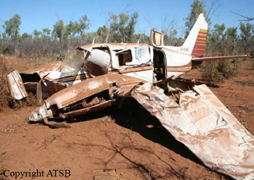
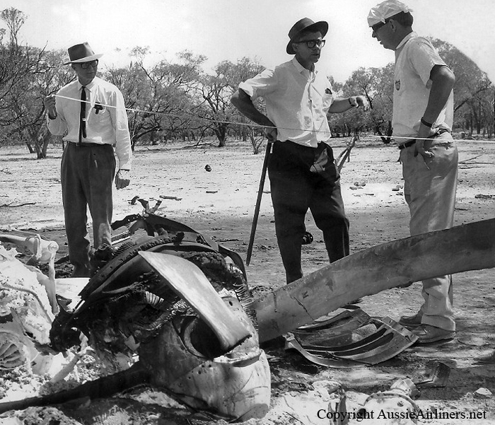
Zone

Crash of a Rockwell Gulfstream 695A Jetprop 1000 near Cloncurry: 3 killed

Date & Time: Nov 4, 2023 at 1430 LT
Operator:
Registration:
VH-HPY
Flight Phase:
Flight Type:
Survivors:
No
Schedule:
Toowoomba - Mount Isa
MSN:
96051
YOM:
1982
Flight number:
BDOG370
Country:
Region:
Crew on board:
3
Crew fatalities:
Pax on board:
0
Pax fatalities:
Other fatalities:
Total fatalities:
3
Circumstances:
In the early afternoon, the twin engine airplane departed Toowoomba Airport on an aerial survey flight under callsign BDOG370 to Mount Isa with three people on board. The purpose of the flight was to conduct a survey mission of the area in case of bushfire. While cruising at an altitude of 28,000 feet, the airplane entered an uncontrolled descent. It reached a rate of descent of 9,600 feet per minute until it crashed in an uninhabited area located approximately 70 km southeast of Cloncurry. All three occupants were killed.

Crash of a Piper PA-31-310 Navajo Chieftain in Mount Isa

Date & Time: Jul 17, 2008 at 0915 LT
Type of aircraft:
Operator:
Registration:
VH-IHR
Flight Type:
Survivors:
Yes
Schedule:
Century Mine - Mount Isa
MSN:
31-8012077
YOM:
1980
Country:
Region:
Crew on board:
1
Crew fatalities:
Pax on board:
0
Pax fatalities:
Other fatalities:
Total fatalities:
0
Captain / Total flying hours:
469
Captain / Total hours on type:
30.00
Circumstances:
On 17 July 2008, at approximately 0915 Eastern Standard Time1, the pilot of a Piper Navajo PA-31 aircraft, registered VH-IHR, was en route from Century Mine, Qld to Mt Isa, Qld when the left engine lost power. The pilot transmitted an urgency broadcast (PAN) to air traffic control (ATC). A short time later, the right engine also lost power. The pilot then transmitted a distress signal (MAYDAY) to ATC stating his intention to carry out an off-field emergency landing. The aircraft impacted terrain 22 km north of Mt Isa, about 4 km from the Barkly Highway, in relatively flat, sparsely wooded bushland (Figure 1). The pilot, who was the sole occupant, sustained serious injuries.
Probable cause:
From the evidence available, the following findings are made with respect to the fuel starvation event and should not be read as apportioning blame or liability to any particular organisation or individual.
- The pilot did not monitor outboard fuel tank quantity during the flight.
- The pilot incorrectly diagnosed the engine power losses.
- The aircraft was not in the correct configuration for the forced landing.
Final Report:

Crash of a Piper PA-31-310 Navajo in Cairns: 8 killed

Date & Time: Sep 2, 1986 at 1408 LT
Type of aircraft:
Operator:
Registration:
VH-CJB
Flight Phase:
Flight Type:
Survivors:
No
Site:
Schedule:
Cairns - Mount Isa
MSN:
31-249
YOM:
1968
Country:
Region:
Crew on board:
1
Crew fatalities:
Pax on board:
7
Pax fatalities:
Other fatalities:
Total fatalities:
8
Circumstances:
The pilot hired the aircraft privately from his employer to conduct a holiday flight during his leave. The journey commenced at Moorabbin on 25 August and the aircraft arrived at Cairns about midday 30 August, after stopovers at Coolangatta and Proserpine. The pilot and his passengers then spent the next three days at leisure in the Cairns area. On the day of the accident, the pilot attended the Cairns Briefing Office where he collected the relevant weather forecasts and submitted a flight plan. The flight plan indicated that the flight would be conducted in accordance with Instrument Flight Rules. It contained a deficiency in that no details were given for the first route segment from Cairns to Biboohra. It is apparent that the pilot had not noticed that the tracks to the west of Cairns, on the relevant enroute chart, emanate from Biboohra and not Cairns. There was no track line which joined Cairns and Biboohra. Such a line might have alerted the pilot at the time he planned the flight. The error in the flight plan was not detected when the plan was submitted. When the pilot was issued with an airways clearance prior to DEPARTURE it was apparent that he did not understand the terms of the clearance, which gave the initial tracking point as Biboohra. The location of this point was explained to the pilot and he subsequently accepted the clearance. He elected to depart using visual procedures, after being offered a choice of these or the published Standard Instrument DEPARTURE profile. A visual DEPARTURE from the particular runway in use allows an aircraft proceeding towards Biboorha to intercept the required track sooner than is possible with an instrument DEPARTURE. The aircraft was issued with takeoff instructions which included clearance for the pilot to make a right turn after takeoff. Witnesses observed that the aircraft complied with this clearance and headed in a southwesterly direction before turning to the north-west and subsequently entering cloud. The cloud base was estimated to be between 2000 and 2500 feet above mean sea level. No further communications were received from the aircraft and a search was commenced that afternoon. The search effort was hampered by the weather and the wreckage was not located until the following afternoon.
Probable cause:
Inspection of the wreckage indicated that the aircraft struck the the top of a ridge line, 250 metres south-west of the highest point of the Mt Williams area. At the time, the aircraft was on a west-north-westerly heading, flying wings level and climbing at a angle of about five degrees. No fault was found with the aircraft that could have contributed to the occurrence. At the time the aircraft entered cloud, the pilot should have reverted to Instrument Flight Rules procedures. To comply with these procedures a pilot is required, inter alia, to ensure that adequate terrain clearance is achieved during climb to the lowest safe altitude. The relevant altitude for the route segment Cairns to Biboohra is 4500 feet above mean sea level (amsl). As the aircraft was apparently under control at the time of impact with the ground at about 3250 feet amsl, it was likely that the pilot had overlooked the lowest safe altitude requirements.
Final Report:

Crash of a Piper PA-61 Aerostar (Ted Smith Aerostar 601) in Charleville

Date & Time: Feb 1, 1979 at 0125 LT
Operator:
Registration:
VH-CPH
Flight Phase:
Flight Type:
Survivors:
Yes
Schedule:
Charleville – Mount Isa
Country:
Region:
Crew on board:
1
Crew fatalities:
Pax on board:
1
Pax fatalities:
Other fatalities:
Total fatalities:
0
Circumstances:
After lift-off at 85 knots, the pilot noted a positive rate of climb before retracting the landing gear and flaps. He then felt the aircraft sink and noted a high indicated rate of descent. Although full power was applied the descent continued until the aircraft struck the runway in a slightly nose-up attitude. The aircraft slid across the overrun area and through a fence before coming to rest. Fire broke out and engulfed the wreckage. At the time of the accident the aircraft weight was more than 200 kg above the maximum allowable and the centre of gravity was 142 mm forward of the forward limit. The pilot had been unable to retain control of the aircraft during the initial climb phase when the flaps were retracted at a relatively low airspeed.
Probable cause:
Overweight at takeoff.
Final Report:

Crash of a De Havilland DH.114 Heron 2E in Cairns: 11 killed

Date & Time: Oct 23, 1975 at 1928 LT
Type of aircraft:
Operator:
Registration:
VH-CLS
Survivors:
No
Schedule:
Alice Springs - Mount Isa - Cairns
MSN:
14067
YOM:
1955
Flight number:
CK1263
Country:
Region:
Crew on board:
3
Crew fatalities:
Pax on board:
8
Pax fatalities:
Other fatalities:
Total fatalities:
11
Captain / Total flying hours:
3859
Captain / Total hours on type:
1030.00
Copilot / Total flying hours:
184
Copilot / Total hours on type:
109
Aircraft flight hours:
14986
Circumstances:
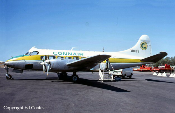
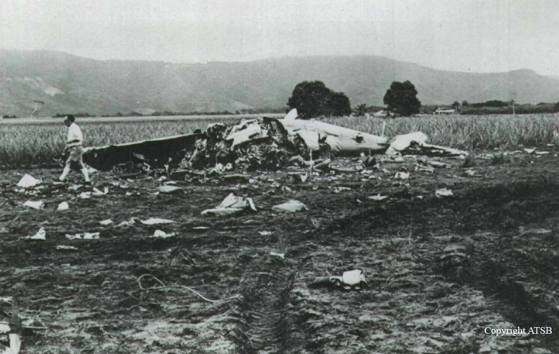
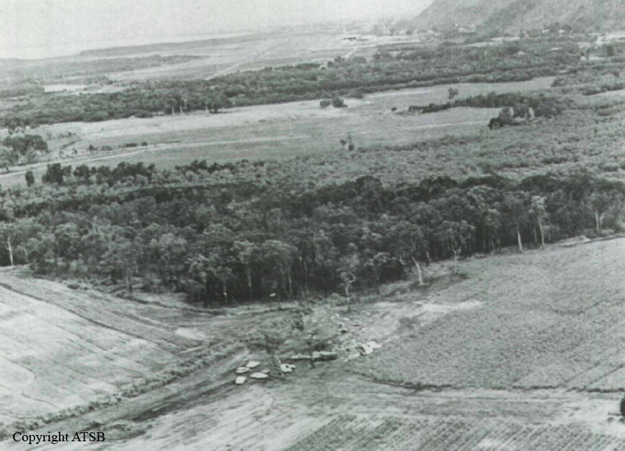
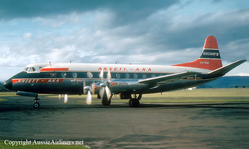
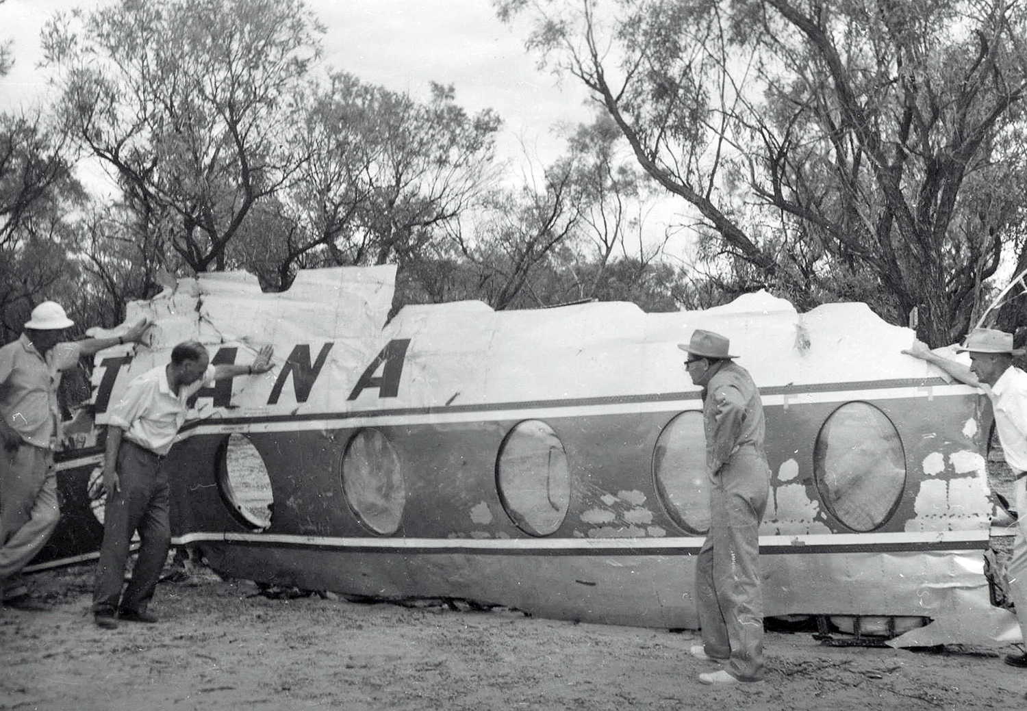
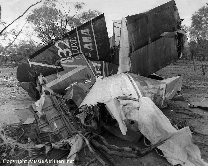
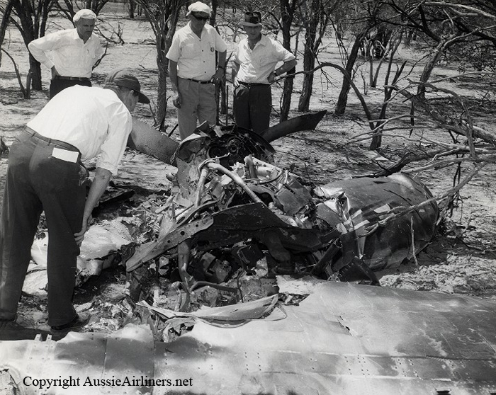
DH-114 Heron registered VH-CLS was operating Connair Flight 1263 from Alice Springs to Cairns landing at Mount Isa en route. At 12:57 hours VH-CLS taxied to runway 30 at Alice Springs and was cleared for takeoff. The flight landed at Mount Isa at 15:35 hours after making a visual approach. At 16:46 hours VH-CLS taxied to runway 34 at Mount Isa, and the flight reported its departure as 16:55 hours at which time it was climbing to its planned cruising altitude of 7000 feet. As the flight progressed position reports at the appropriate reporting points were received. At 18:01 hours, VH-CLS advised that it was descending to cruise at 6000 feet. Subsequently, at 18:49 hours, VH-CLS reported as being at the Saucebottle Creek position, 146 km southwest of Cairns, at an altitude of 6000 feet. The crew indicated an ETA at the Biboohra VOR, 35 km west of Cairns, of 19:12. VH-CLS was then advised by the Cairns aerodrome/approach controller, through the Cairns Flight Service Unit (FSU), to expect an ILS approach to runway 15 at Cairns Airport. At 18:54 hours the Cairns aerodrome/approach controller issued an air traffic clearance, for transmission through the Cairns FSU, authorising VH-CLS to enter the control area via the 049 degree radial of the Biboohra VOR cruising at 6000 feet and using an altimeter setting of 1006 millibars. At about 18:55 hours, the Weather Service Office (WSO) located at Cairns Airport observed a thunderstorm, without precipitation, in the vicinity of the airport and the following 'special' aerodrome weather report was issued: Wind : 360 degrees at 6 knots, visibility : 10 km or more, thunderstorm without precipitation, 1/8 cumulonimbus clouds, base 3000 feet, 4/8 cumulus, base 2300 feet, 4/8 strato cumulus, base 4000 feet. This was reported to the crew. At 19:10 hours, VH-CLS reported to the Cairns aerodrome/approach controller that it was over the Biboohra VOR at 6000 feet and, following confirmation by VH-CLS that its 'preferred approach' was an ILS approach, it was cleared 'on the Biboohra zero four nine radial, descend to three seven zero zero for an ILS approach runway one five, and report at Buchan Locator'. VH-CLS acknowledged this instruction and advised that the aircraft was leaving 6000 feet. At 19:17:29 hours, VH-CLS reported over the Buchan Locator turning outbound onto a heading of 330 degrees this being the standard ILS procedure; the aerodrome/approach controller cleared the aircraft for an ILS approach and instructed it to report leaving 3700 feet. At 19:20:54 hours, VH-CLS reported 'leaving three seven zero zero' implying that the aircraft had commenced the final approach segment of the ILS approach. The aerodrome/approach controller acknowledged the report and radioed: 'wind from the northwest, maximum downwind component runway one five not above six knots, runway wet, clear to land'. At 19:22:53 hours, the controller notified VH-CLS 'there's a moderately heavy shower at the field now, visibility er is reducing as the shower moves south, visibility to the south at the moment er in excess of four thousand metres, high intensity approach and runway lighting is on, advise when you would like the intensity decreased'. VH-CLS acknowledged. At 19:26:23 hours, VH-CLS reported 'going round' and the aerodrome/approach controller instructed VH-CLS to 'make missed approach on a heading of zero three five and climb to three seven zero zero'. VH-CLS turned away from the airport, descended to a low height above terrain, and completed about 270 degrees of a left hand orbit. It then entered a turn to the right during which it descended and crashed.
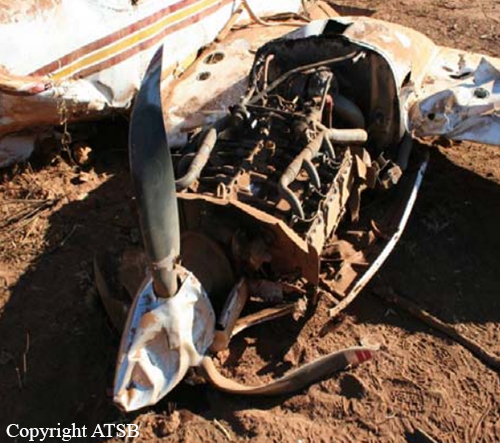
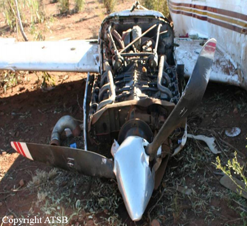
Probable cause:
The cause of the accident was that, following misalignment of the aircraft with the runway and abandonment of the landing approach, the pilot in command did not immediately initiate a climb to a safe altitude. Why such action was not taken has not been determined.
Final Report:

Crash of a Vickers 832 Viscount near Winton: 24 killed

Date & Time: Sep 22, 1966 at 1303 LT
Type of aircraft:
Operator:
Registration:
VH-RMI
Flight Phase:
Survivors:
No
Schedule:
Mount Isa – Longreach – Brisbane
MSN:
416
YOM:
1959
Flight number:
AN149
Country:
Region:
Crew on board:
4
Crew fatalities:
Pax on board:
20
Pax fatalities:
Other fatalities:
Total fatalities:
24
Captain / Total flying hours:
14288
Captain / Total hours on type:
10003.00
Copilot / Total flying hours:
2803
Copilot / Total hours on type:
249
Aircraft flight hours:
18634
Aircraft flight cycles:
6586
Circumstances:
On 22 September 1966, the Viscount 832 aircraft registered VH-RMI, was engaged on a regular public transport service, designated Flight 149, from Mt. Isa to Longreach in Queensland, Australia, with a crew of four and twenty passengers on board. The flight departed from Mt. Isa at 1208 hours Australian Eastern Standard Time climbing to Flight Level 175 with an expected time interval of 73 minutes to Longreach. The flight progressed, apparently uneventfully, until 1252 hours when the Longreach Flight Service Unit heard the crew of VH-RMI say that it was on an emergency descent and to stand by. Two minutes later the aircraft advised that there were fire warnings in respect of Nos. 1 and 2 engines, that one of these warning conditions had ceased and that the propeller of the other engine could not be feathered. At 1259 hours information from the crew of VH-RMI, relayed to Longreach through the crew of another aircraft in the vicinity, indicated that there was a visible fire in No. 2 engine and that the aircraft was diverting below 5 000 ft to Winton. The town of Winton is located some 20 miles to port of the planned track and is 90 miles short of Longreach. No further communications were received from the aircraft but at 1303 hours a number of people located in the Winton area saw black smoke in the air west of the town, and it was subsequently established that this was associated with VH-RMI which had crashed in light timber on level ground some 131 miles short of the Winton aerodrome. The aircraft disintegrated on impact and all 24 occupants have been killed.
Probable cause:
The probable cause of the accident was that the means of securing the oil metering unit to the No. 2 cabin blower became ineffective and this led to the initiation of a fire within the blower, which propagated to the w$ng fuel tank and substantially reduced the strength of the main spar upper boom. It is probable that the separation of the oil metering unit arose from an out-of-balance condition induced by rotor break-up but the source of the rotor break-up could not be determined.
The following findings were reported:
- The crash of the aircraft followed the failure in an upward direction of the port wing between No. 1 and No. 2 engines at approximately 1302:30 hours Eastern Standard Time when the aircraft was at a height of 3 500 ft to 4 000 ft above ground level,
- The port wing failed as a result of a weakening of the main spar due to a fire in No. 2 cell of No. 2 fuel tank,
- The fire originated in the No. 2 cabin blower and travelled through the rear of No. 2 engine nacelle and port wheel bay to the fuel tank,
- The fire in No. 2 cabin blower was initiated as a result of a rotor break-up, the blower subsequently being driven in an out-of-balance condition by the quill shaft long enough for the metering unit to become separated from the rear end cover by the resulting vibration,
- The metering unit continued to be driven after separation and lubricating oil continued to be supplied. The driven rotor lost its rear stub shaft radial location and caused metal-to-metal contact which generated a temperature sufficiently high to ignite the oil in that area,
- It is not possible on the evidence to determine what was the cause of the rotor break-up.
Final Report:

Crash of a De Havilland DH.86 Express near Brisbane: 9 killed

Date & Time: Feb 20, 1942 at 0830 LT
Type of aircraft:
Operator:
Registration:
VH-USE
Flight Phase:
Survivors:
No
Schedule:
Brisbane – Mount Isa – Darwin
MSN:
2309
YOM:
1935
Country:
Region:
Crew on board:
2
Crew fatalities:
Pax on board:
7
Pax fatalities:
Other fatalities:
Total fatalities:
9
Circumstances:
The airplane was late and departed Brisbane-Archerfield with two hours delay. Few minutes after takeoff, it entered an area of clouds with heavy rain falls. It entered an uncontrolled descent, spiraled to the ground and crashed in a wooded area located in Belmont (Mount Petrie), some 13 km south of Archerfield Airport. All nine occupants were killed.
Crew:
Cpt Charles Henry Cecil Swaffield,
C/O Lindsay Stuart Marshall.
Photo: www.ozatwar.com
Probable cause:
Three quarters of the fin had been found quite some distance from the main wreckage of the aircraft. Nevertheless, the subsequent official inquiry into the loss was inconclusive.