Crash of a Cessna 208B Grand Caravan on Lizard Island

Date & Time: Jan 8, 2024 at 0700 LT
Type of aircraft:
Registration:
VH-NWJ
Survivors:
Yes
Schedule:
Lizard Island - Cairns
MSN:
208B-2161
YOM:
2010
Country:
Region:
Crew on board:
2
Crew fatalities:
Pax on board:
8
Pax fatalities:
Other fatalities:
Total fatalities:
0
Circumstances:
After takeoff from Lizard Island Airport, the crew continued to climb until he reached the altitude of 4,000 feet. Due to an engine malfunction, the crew decided to return to Lizard Island Airport but the airplane overshot and crashed, coming to rest upside down. All 10 occupants were injured and evacuated.

Crash of a Cessna 404 Titan in Lockhart River: 5 killed

Date & Time: Mar 11, 2020 at 0919 LT
Type of aircraft:
Registration:
VH-OZO
Survivors:
No
Schedule:
Cairns – Lockhart River
MSN:
404-0653
YOM:
1980
Country:
Region:
Crew on board:
1
Crew fatalities:
Pax on board:
4
Pax fatalities:
Other fatalities:
Total fatalities:
5
Captain / Total flying hours:
3220
Captain / Total hours on type:
399.00
Circumstances:
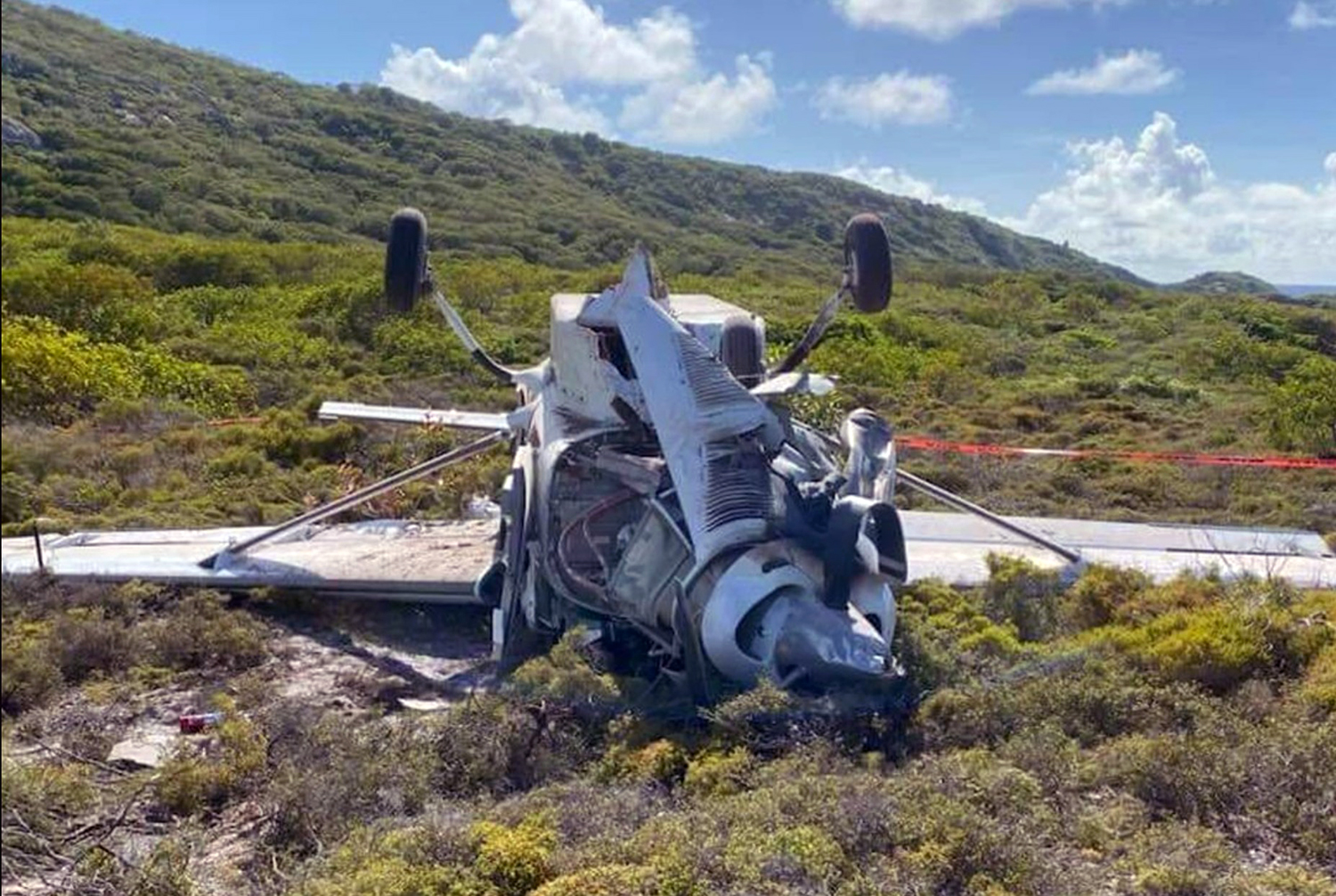
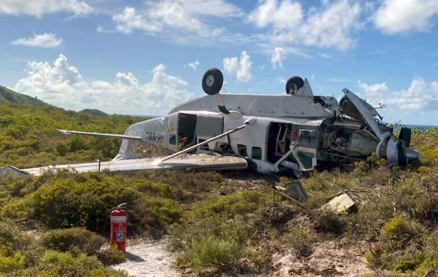
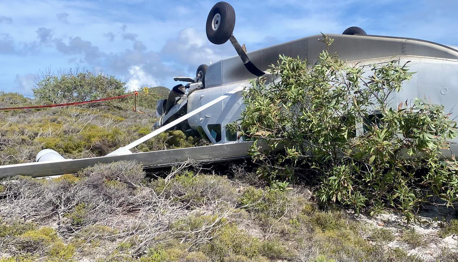
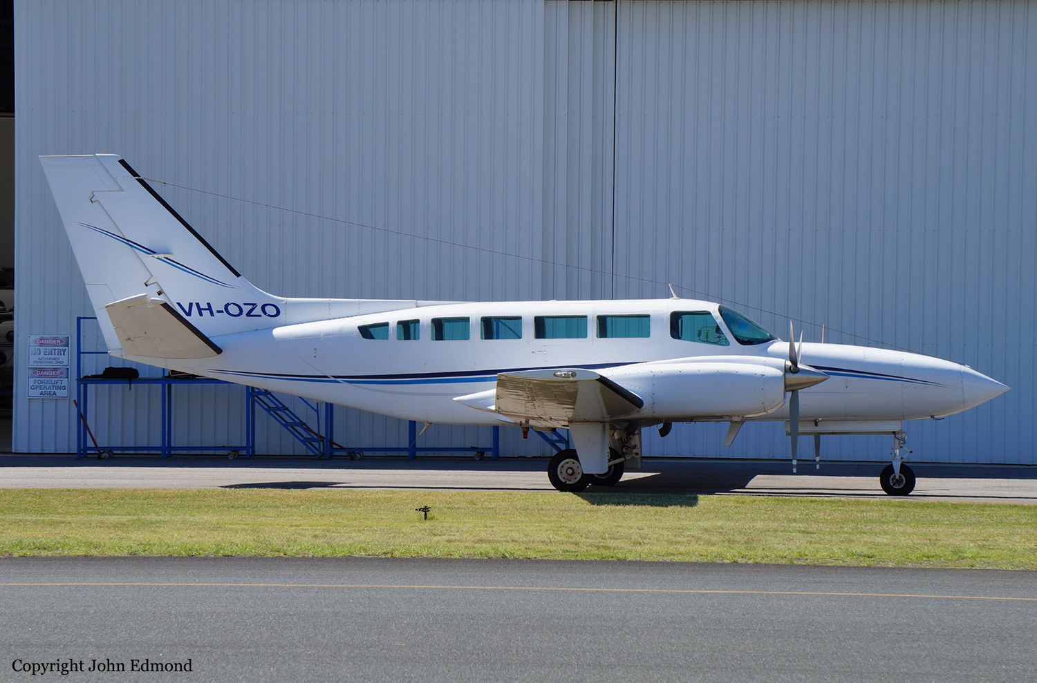
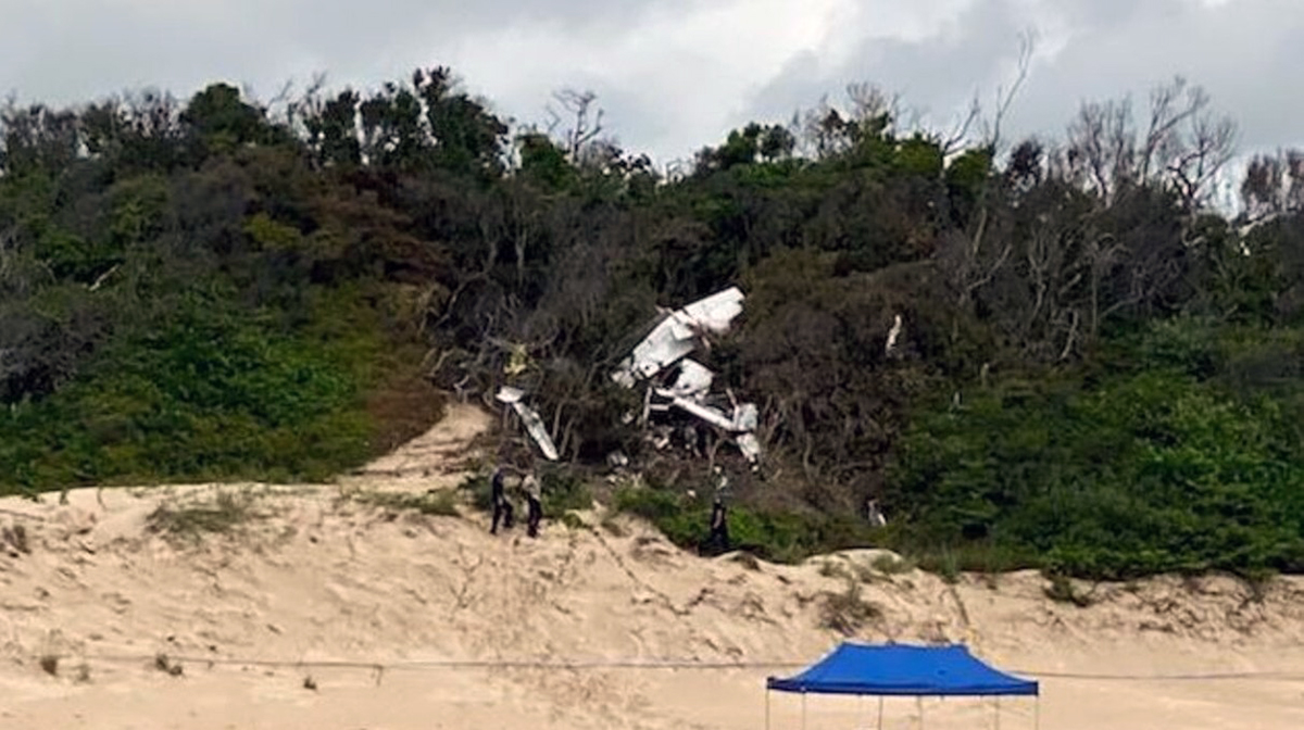
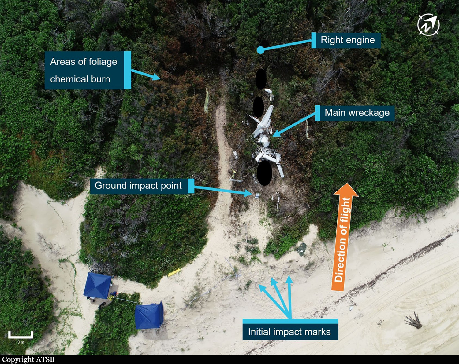
On 11 March 2020, a Cessna 404 aircraft, registered VH-OZO, was being operated by Air Connect Australia to conduct a passenger charter flight from Cairns to Lockhart River, Queensland. On board were the pilot and 4 passengers, and the flight was being conducted under the instrument flight rules (IFR). Consistent with the forecast, there were areas of cloud and rain that significantly reduced visibility at Lockhart River Airport. On descent, the pilot obtained the latest weather information from the airport’s automated weather information system (AWIS) and soon after commenced an area navigation (RNAV) global satellite system (GNSS) instrument approach to runway 30. The pilot conducted the first approach consistent with the recommended (3°) constant descent profile, and the aircraft kept descending through the minimum descent altitude (MDA) of 730 ft and passed the missed approach point (MAPt). At about 400 ft, the pilot commenced a missed approach. After conducting the missed approach, the pilot immediately commenced a second RNAV GNSS approach to runway 30. During this approach, the pilot commenced descent from 3,500 ft about 2.7 NM prior to the intermediate fix (or 12.7 NM prior to the MAPt). The descent was flown at about a normal 3° flight path, although about 1,000 ft below the recommended descent profile. While continuing on this descent profile, the aircraft descended below the MDA. It then kept descending until it collided with terrain 6.4 km (3.5 NM) short of the runway. The pilot and 4 passengers were fatally injured, and the aircraft was destroyed.
Probable cause:
The accident was the consequence of a controlled flight into terrain.
The following contributing factors were identified:
• While the pilot was operating in the vicinity of Lockhart River Airport, there were areas of cloud and rain that significantly reduced visibility and increased the risk of controlled flight into terrain.
In particular, the aircraft probably entered areas of significantly reduced visibility during the second approach.
• After an area navigation (RNAV) global satellite system (GNSS) approach to runway 30 and missed approach, the pilot immediately conducted another approach to the same runway that was on a similar gradient to the recommended descent profile but displaced about 1,000 ft below that profile. While continuing on this descent profile, the aircraft descended below a segment minimum safe altitude and the minimum descent altitude, then kept descending until the collision with terrain about 6 km before the runway threshold.
• Although the exact reasons for the aircraft being significantly below the recommended descent profile and the continued descent below the minimum descent altitude could not be determined, it was evident that the pilot did not effectively monitor the aircraft’s altitude and descent rate for an extended period.
• When passing the final approach fix (FAF), the aircraft’s lateral position was at about full-scale deflection on the course deviation indicator (CDI), and it then exceeded full-scale deflection for
an extended period. In accordance with the operator’s stabilized approach procedures, a missed approach should have been conducted if the aircraft exceeded half full-scale deflection at the FAF, however a missed approach was not conducted.
• The pilot was probably experiencing a very high workload during periods of the second approach. In addition to the normal high workload associated with a single pilot hand flying an approach in instrument meteorological conditions, the pilot’s workload was elevated due to conducting an immediate entry into the second approach, conducting the approach in a different manner to their normal method, the need to correct lateral tracking deviations throughout the approach, and higher than appropriate speeds in the final approach segment.
• The aircraft was not fitted with a terrain avoidance and warning system (TAWS). Such a system would have provided visual and aural alerts to the pilot of the approaching terrain for an extended period, reducing the risk of controlled flight into terrain.
• Although the aircraft was fitted with a GPS/navigational system suitable for an area navigation (RNAV) global satellite system (GNSS) approach and other non-precision approaches, it was not fitted with a system that provided vertical guidance information, which would have explicitly indicated that the aircraft was well below the recommended descent profile. Although the operator had specified a flight profile for a straight-in approaches and stabilized approach criteria in its operations manual, and encouraged the use of stabilized approaches, there were limitations with the design of these procedures. In addition, there were limitations with other risk controls for minimizing the risk of controlled flight into terrain (CFIT), including no procedures or guidance for the use of the terrain awareness function on the aircraft’s GNS 430W GPS/navigational units and limited monitoring of the conduct of line operations.

Other factors that increased risk:
• Although an applicable height of 1,000 ft for stabilized approach criteria in instrument meteorological conditions has been widely recommended by organizations such as the International Civil Aviation Organization for over 20 years, the Civil Aviation Safety Authority had not provided formal guidance information to Australian operators regarding the content of stabilized approach criteria. (Safety issue)
• The Australian requirements for installing a terrain avoidance and warning system (TAWS) were less than those of other comparable countries for some types of small aeroplanes conducting air transport operations, and the requirements were not consistent with International Civil Aviation Organization (ICAO) standards and recommended practices. More specifically, although there was a TAWS requirement in Australia for turbine-engine aeroplanes carrying 10 or more passengers under the instrument flight rules:
- There was no requirement for piston-engine aeroplanes to be fitted with a TAWS, even though this was an ICAO standard for such aeroplanes authorized to carry 10 or more passengers, and this standard had been adopted as a requirement in many comparable countries.
- There was no requirement for turbine-engine aeroplanes authorized to carry 6–9 passengers to be fitted with a TAWS, even though this had been an ICAO recommended practice since 2007, and this recommended practice had been adopted as a requirement in many comparable countries. (Safety Issue)

Other findings:
• The forecast weather at Lockhart River for the time of the aircraft’s arrival required the pilot to plan for 60 minutes holding or diversion to an alternate aerodrome. The aircraft had sufficient fuel for that purpose; and the aircraft had sufficient fuel to conduct the flight from Cairns to Lockhart River and return, with additional fuel for holding on both sectors if required.
• There was no evidence of any organizational or commercial pressure to conduct the flight to Lockhart River or to complete the flight once to commenced.
• Based on the available evidence, it is very unlikely that the pilot was incapacitated or impaired during the flight.
• There was no evidence of any aircraft system or mechanical anomalies that would have directly influenced the accident. However, as a consequence of extensive aircraft damage, it was not possible to be conclusive about the aircraft’s serviceability.
• The aircraft was fitted with Garmin GNS 430W GPS/navigational units that could be configured to provide visual (but not aural) terrain alerts. However, it could not be determined whether the
terrain awareness function was selected on during the accident flight.
Final Report:

Crash of a Rockwell Shrike Commander 500S off Horn Island: 1 killed

Date & Time: Feb 24, 2011 at 0800 LT
Operator:
Registration:
VH-WZU
Flight Type:
Survivors:
No
Schedule:
Cairns - Horn Island
MSN:
3060
YOM:
1970
Country:
Region:
Crew on board:
1
Crew fatalities:
Pax on board:
0
Pax fatalities:
Other fatalities:
Total fatalities:
1
Captain / Total flying hours:
4154
Captain / Total hours on type:
209.00
Aircraft flight hours:
17545
Circumstances:
At 0445 Eastern Standard Time on 24 February 2011, the pilot of an Aero Commander 500S, registered VH-WZU, commenced a freight charter flight from Cairns to Horn Island, Queensland under the instrument flight rules. The aircraft arrived in the Horn Island area at about 0720 and the pilot advised air traffic control that he intended holding east of the island due to low cloud and rain. At about 0750 he advised pilots in the area that he was north of Horn Island and was intending to commence a visual approach. When the aircraft did not arrive a search was commenced but the pilot and aircraft were not found. On about 10 October 2011, the wreckage was located on the seabed about 26 km north-north-west of Horn Island.
Probable cause:
The ATSB found that the aircraft had not broken up in flight and that it impacted the water at a relatively low speed and a near wings-level attitude, consistent with it being under control at impact. It is likely that the pilot encountered rain and reduced visibility when manoeuvring to commence a visual approach. However, there was insufficient evidence available to determine why the aircraft impacted the water.
Several aspects of the flight increased risk. The pilot had less than 4 hours sleep during the night before the flight and the operator did not have any procedures or guidance in place to minimize the fatigue risk associated with early starts. In addition, the pilot, who was also the operator’s chief pilot, had either not met the recency requirements or did not have an endorsement to conduct the types of instrument approaches available at Horn Island and several other locations frequently used by the operator.
Final Report:

Crash of a Cessna 208 Caravan I off Green Island

Date & Time: Feb 8, 2004 at 1610 LT
Type of aircraft:
Operator:
Registration:
VH-CYC
Flight Phase:
Flight Type:
Survivors:
Yes
Schedule:
Cairns - Cairns
MSN:
208-0108
YOM:
1986
Country:
Region:
Crew on board:
1
Crew fatalities:
Pax on board:
1
Pax fatalities:
Other fatalities:
Total fatalities:
0
Captain / Total flying hours:
5333
Captain / Total hours on type:
211.00
Circumstances:
The aircraft, with two pilots on board, was being operated for pilot type endorsement training. Air Traffic Control (ATC) had cleared the pilots to conduct upper level air work between 4,000 and 5,000 ft above mean sea level (AMSL) within a 5 NM radius of Green Island, Queensland. Following the upper level air work, the crew requested, and were granted a clearance for, a simulated engine failure and descent to 2,000 ft. The pilot in command (PIC) reported that while completing the simulated engine failure training, he had retarded the power lever to the FLIGHT IDLE stop and the fuel condition lever to the LOW IDLE range, setting a value of 55% engine gas generator speed (Ng). The pilot under training then set the glide attitude at the best glide speed (for the operating weight) of about 79 knots indicated airspeed (KIAS). The PIC then instructed the pilot under training to place the propeller into the feathered position, and maintain best glide speed. The PIC reported that he instructed the pilot under training to advance the emergency power lever (EPL) to simulate manual introduction of fuel to the engine. According to the PIC, he then noticed that there was no engine torque increase, with the engine inter-turbine temperature (ITT or T5) and Ng rapidly decreasing, and a strong smell of fuel in the cockpit. While the pilot under training flew the aircraft, the PIC placed the ignition switch to the ON position and also selected START on the engine starter switch. He then reportedly placed the EPL to the CLOSED position, the propeller to the UNFEATHERED position and the fuel condition lever to the IDLE CUTOFF position to clear the excess fuel from the engine. The PIC reported that they then increased the aircraft airspeed to 120 KIAS, at which point he reintroduced fuel into the engine by advancing the fuel condition lever. He reported that following these actions, the strong fuel smell persisted. As the aircraft approached 1,500 ft, the PIC broadcast a MAYDAY, informing ATC that they had a 'flameout' of the engine and that they were going to complete a forced landing water ditching near Green Island. While the pilot under training flew the aircraft, the PIC placed the propeller into the feathered position, closed the fuel condition lever to the IDLE CUTOFF position and turned off the starter and ignition switches. They then completed a successful landing in a depth of about 2 m of water near Green Island. The pilots evacuated the aircraft without injury. The aircraft, which sustained minor damage during the ditching, but subsequent substantial damage due to salt water immersion, was recovered to the mainland. Following examination of all connections and control linkages, the engine was removed for examination under the supervision of the Australian Transport Safety Bureau (ATSB) at the engine manufacturer's overhaul facility. The engine trend monitoring (ETM) data logger was also removed from the aircraft for examination.
Probable cause:
The following factors were identified:
1. The pilots of CYC were conducting in-flight familiarization training using the emergency power lever. That procedure was not contained in the aircraft manufacturer's pilot operating handbook.
2. The engine manufacturer's documentation contained information on the use of the emergency power lever, which did not preclude the use of the emergency power lever for in-flight familiarization training.
3. The engine sustained a flameout at an altitude above mean sea level from which reignition of the engine was not successfully completed.
4. Erosion of the first-stage compressor blades would have reduced the aerodynamic efficiency of the compressor blades.
Final Report:

Crash of a Cessna 340A in Cairns

Date & Time: Mar 9, 2002 at 1729 LT
Type of aircraft:
Registration:
N79GW
Flight Type:
Survivors:
Yes
Schedule:
Bankstown – Cairns
MSN:
340A-0680
YOM:
1979
Country:
Region:
Crew on board:
1
Crew fatalities:
Pax on board:
3
Pax fatalities:
Other fatalities:
Total fatalities:
0
Circumstances:
The pilot of a Cessna 340 departed Bankstown, NSW at 1223 ESuT, for Townsville, Qld via Walgett, St George, Roma, Emerald and Clermont. He reported that he climbed the aircraft to 16,000 ft and adopted a long range power setting of about 49% which equated to a true air speed (TAS) of 168 kts and a fuel burn of 141 lbs per hour. As the pilot approached the ‘OLDER’ waypoint north of Clermont, he reviewed his fuel situation and, because of a strong tailwind decided to continue on to Cairns. He informed an enroute controller of his decision and requested, for fuel planning purposes, a clearance to allow him to track in the opposite direction on a one-way air route. The controller was unable to approve his request but offered the pilot a direct track to Biboohra, a navigation aid 20 NM west of Cairns. The pilot accepted the amended track with the intention of later requesting a more direct route to Cairns. About 15 minutes later, the pilot requested a more direct track, but was told to call the approach controller for a possible clearance. He contacted the approach controller and told the controller that he had minimum fuel. The controller asked the pilot if he was declaring an emergency, to which he replied affirmative. The pilot later commented that he did this in the hope of expediting his arrival. He was instructed to descend to 6,500 ft and track direct to Cairns. The controller asked the pilot if he preferred to join the runway 15 circuit via a left downwind or right downwind, to which the pilot requested to join a left downwind. The pilot later commented that the aircraft fuel flow gauges were indicating a total flow of 140 lbs per hour and the fuel quantity gauges for the selected main tanks, although wandering somewhat, were ‘displaying a healthy amount’ considering that he was about 12 NM from his destination. As the pilot approached 6,500 ft, he requested a clearance for further descent, to which the controller instructed the pilot to descend to 4,000 ft. As the aircraft descended to 4,000 ft, the pilot saw Cairns City, but could not see the runway at Cairns airport. The aircraft's distance measuring equipment (DME) indicated 9 NM to the DME navigation aid at Cairns Airport. The pilot reported that at about this time, he observed one of the fuel flow gauges indicating zero, while at the same time, one or both engines began to surge and run roughly. He immediately informed the controller of the situation. The controller asked the pilot if he was familiar with a local airstrip (Greenhill which is 10 NM to the southeast of Cairns airport), to which the pilot replied that he wasn't. The controller indicated to the pilot that the strip was situated in his two o'clock position at a range of about two miles and to be aware of power lines and the sugar cane. The pilot was unsure of what to look for and was unable to see the strip, but after conducting a number of steep turns, saw a cleared strip in a field. He decided that he had to land. He extended the landing gear, but realised that the aircraft was too high and attempted a 360-degree steep turn onto final to reposition the aircraft. However, the airspeed was rapidly decreasing and there was insufficient height to complete the approach. At 1729 EST, the aircraft impacted the ground short of the strip and slid for about 20 metres. The pilot was seriously injured and the passengers received minor injuries.
Probable cause:
The reason for the initial fuel flow fluctuations was not identified by the pilot. It is likely that the pilot assumed the zero reading indicated impending fuel exhaustion and concentrated on conducting a landing in unfamiliar terrain. During the landing approach the pilot lost control of the aircraft and it descended rapidly to the ground.
Final Report:

Crash of a Rockwell Shrike Commander 500S on Thornton Peak: 4 killed

Date & Time: Apr 10, 2001 at 0725 LT
Operator:
Registration:
VH-UJB
Flight Phase:
Survivors:
No
Site:
Schedule:
Cairns - Hicks Island
MSN:
500-3152
YOM:
1973
Country:
Region:
Crew on board:
1
Crew fatalities:
Pax on board:
3
Pax fatalities:
Other fatalities:
Total fatalities:
4
Captain / Total flying hours:
9680
Captain / Total hours on type:
2402.00
Circumstances:
The aircraft departed Cairns airport at 0707 Eastern Standard Time (EST) on a charter flight to Hicks Island. The aircraft was being operated under the Instrument Flight Rules (IFR) and the expected flight time was 2 hours. Shortly after takeoff the pilot requested an amended altitude of 4,000 ft. He indicated that he was able to continue flight with visual reference to the ground or water. Air Traffic Services (ATS) issued the amended altitude as requested. The IFR Lowest Safe Altitude for the initial route sector to be flown was 6,000 ft Above Mean Sea Level (AMSL). Data recorded by ATS indicated that approximately 13 minutes after departure, the aircraft disappeared from radar at a position 46NM north of Cairns. At the last known radar position the aircraft was cruising at a ground speed of 180 kts and at an altitude of 4,000 ft AMSL. An extensive search located the wreckage the following afternoon at a location consistent with the last known radar position, on the north-western side of Thornton Peak at an altitude of approximately 4,000 ft (1219 metres) AMSL. The aircraft was destroyed by impact forces and post-impact fire. The pilot and three passengers received fatal injuries. Thornton Peak is the third highest mountain in Queensland and is marked on topographic maps as 4,507 ft (1,374 metres) in elevation. Local residents reported that the mountain was covered by cloud and swept by strong winds for most of the year. The aircraft had been observed by witnesses approximately two minutes prior to impact cruising at high speed, on a constant north-westerly heading, in a wings level attitude and with flaps and landing gear retracted. They stated that the engines appeared to sound normal.
Probable cause:
Radar data recorded by Air Traffic Services and witness reports indicated that the aircraft was flying straight and level and maintaining a constant airspeed. Therefore, it is unlikely that the aircraft was experiencing any instrumentation or engine problems. Why the pilot continued flight into marginal weather conditions at an altitude that was insufficient to ensure terrain clearance, could not be established. The aircraft was flown at an altitude that was insufficient to ensure terrain clearance.
Final Report:

Crash of a Mitsubishi MU-2B-35 Marquise in the Pacific Ocean: 1 killed

Date & Time: Dec 9, 1988 at 0721 LT
Type of aircraft:
Registration:
N296MA
Flight Phase:
Flight Type:
Survivors:
No
Schedule:
Tulsa – Oakland – Honolulu – Majuro – Cairns
MSN:
592
YOM:
1973
Country:
Region:
Crew on board:
1
Crew fatalities:
Pax on board:
0
Pax fatalities:
Other fatalities:
Total fatalities:
1
Circumstances:
During a flight at night from Majuro, Marshall Islands to Cairns, Australia, the pilot requested a descent from FL190 to 12,000 feet to remove ice from the airframe. Later, he requested a climb to FL200. After starting the climb, he made a mayday call to Sydney flight service and reported the aircraft was in an uncontrolled descent. No further transmission was received from the aircraft. The aircraft was presumed to have crashed at sea, about 370 miles east-northeast of Cairns. Neither the aircraft nor the pilot was found. Thunderstorms were reported in the area and the pilot reported being in the clouds during an earlier descent to 12,000 feet. An investigation revealed the aircraft was being ferried from Tulsa, OK. A previous pilot, who flew it to Oakland, refused to continue the flight due to a cabin pressurization problem. A 2nd pilot, who was going to continue the flight, returned to Oakland and landed the aircraft in an overweight condition, which resulted in structural damage. A 3rd pilot continued the flight, making stops in Hawaii and the Marshall Islands.
Probable cause:
Occurrence #1: missing aircraft
Phase of operation: unknown
Findings
1. (c) reason for occurrence undetermined
2. Operation with known deficiencies in equipment - performed - pilot in command
3. Light condition - dark night
4. Weather condition - thunderstorm
5. Weather condition - icing conditions
Final Report:

Crash of a Rockwell Shrike Commander 500S in Mount Garnet

Date & Time: May 20, 1988 at 1750 LT
Operator:
Registration:
VH-SDI
Survivors:
Yes
Schedule:
Kidston – Cairns
MSN:
500-3188
YOM:
1974
Country:
Region:
Crew on board:
1
Crew fatalities:
Pax on board:
2
Pax fatalities:
Other fatalities:
Total fatalities:
0
Circumstances:
The pilot was temporarily replacing the pilot who normally flew the aircraft. After arriving at Kidston he checked the fuel quantity gauge and decided that there was sufficient fuel on board for the return flight. As the aircraft approached top of climb, the pilot found that the fuel gauge indicated a lower fuel quantity than he had expected. He re-checked the indicated quantity after the aircraft was established in cruise and decided that sufficient fuel still remained to complete the planned flight. Shortly after passing Mt Garnet both engine fuel flow gauges began to fluctuate and the engines began to surge. The pilot immediately turned the aircraft towards the Mt Garnet strip, but shortly afterwards both engines failed. The pilot attempted to glide the aircraft to the strip, but it collided with trees and came to rest about one kilometre from the runway 27 threshold. All three occupants escaped with minor injuries and the aircraft was damaged beyond repair.
Probable cause:
Both engines had failed due to fuel exhaustion. The pilot normally flew a different type of aircraft, this aircraft only being used by the company to supplement its services. For company aircraft normal route fuel requirements are specified. As a result, there was little need for him to make significant fuel calculations. On this occasion, the pilot found he had little time between his arrival at Cairns and the scheduled DEPARTURE of his next flight. He ordered that only 80 litres of fuel be added to the aircraft tanks. The calculated fuel burn for the proposed return flight to Kidston was approximately 240 litres. However, on DEPARTURE from Cairns it was estimated that only about 220 litres of fuel was in the aircraft tanks. Refuelling facilities were available at Kidston but no fuel was added to the aircraft tanks.
The following factors were considered relevant to the development of the accident:
1. The aircraft design is such that the fuel quantity can only be determined by the gauge, unless the tanks are full.
2. The preflight preparation, in relation to fuel requirements, carried out by the pilot was inadequate.
3. The pilot lacked recent experience at more complex fuel calculations.
Final Report:

Crash of a Cessna 402B in Mount Dianne: 5 killed

Date & Time: Feb 2, 1987 at 0639 LT
Type of aircraft:
Operator:
Registration:
VH-TLQ
Survivors:
Yes
Schedule:
Cairns – Mount Dianne
MSN:
402B-1236
YOM:
1977
Country:
Region:
Crew on board:
1
Crew fatalities:
Pax on board:
7
Pax fatalities:
Other fatalities:
Total fatalities:
5
Circumstances:
The aircraft was the first of a group of four aircraft being used to return staff to an alluvial gold mine after a weekend break. The weather in the area of the destination was not suitable for a visual arrival and the aircraft was initially held for several minutes in an area five kilometres to the south of the strip, awaiting an improvement in the weather. The aircraft was then flown towards the strip and the pilot reported to a following aircraft that there had been a lot of rain and that the strip looked wet. He also advised that he intended to carry out a precautionary circuit and check if it was safe to land. No further transmissions were received from VH-TLQ. The wreckage of the aircraft was subsequently found burning in a river valley, 300 metres west of the threshold of runway 34. Surviving passengers stated that the aircraft struck trees shortly before impact. There were no ground witnesses. The aircraft had impacted the ground in a steep nose down left wing low attitude, at a low forward speed, then cartwheeled up rising ground before coming to rest inverted, 42 metres from the point of impact. The cabin area was destroyed by an ensuing fire.
Probable cause:
An inspection of wreckage did not reveal any mechanical defect or failure that could have contributed to the accident. The reasons for the apparent loss of control of the aircraft could not be determined.
Final Report:

Crash of a Piper PA-31-310 Navajo in Cairns: 8 killed

Date & Time: Sep 2, 1986 at 1408 LT
Type of aircraft:
Operator:
Registration:
VH-CJB
Flight Phase:
Flight Type:
Survivors:
No
Site:
Schedule:
Cairns - Mount Isa
MSN:
31-249
YOM:
1968
Country:
Region:
Crew on board:
1
Crew fatalities:
Pax on board:
7
Pax fatalities:
Other fatalities:
Total fatalities:
8
Circumstances:
The pilot hired the aircraft privately from his employer to conduct a holiday flight during his leave. The journey commenced at Moorabbin on 25 August and the aircraft arrived at Cairns about midday 30 August, after stopovers at Coolangatta and Proserpine. The pilot and his passengers then spent the next three days at leisure in the Cairns area. On the day of the accident, the pilot attended the Cairns Briefing Office where he collected the relevant weather forecasts and submitted a flight plan. The flight plan indicated that the flight would be conducted in accordance with Instrument Flight Rules. It contained a deficiency in that no details were given for the first route segment from Cairns to Biboohra. It is apparent that the pilot had not noticed that the tracks to the west of Cairns, on the relevant enroute chart, emanate from Biboohra and not Cairns. There was no track line which joined Cairns and Biboohra. Such a line might have alerted the pilot at the time he planned the flight. The error in the flight plan was not detected when the plan was submitted. When the pilot was issued with an airways clearance prior to DEPARTURE it was apparent that he did not understand the terms of the clearance, which gave the initial tracking point as Biboohra. The location of this point was explained to the pilot and he subsequently accepted the clearance. He elected to depart using visual procedures, after being offered a choice of these or the published Standard Instrument DEPARTURE profile. A visual DEPARTURE from the particular runway in use allows an aircraft proceeding towards Biboorha to intercept the required track sooner than is possible with an instrument DEPARTURE. The aircraft was issued with takeoff instructions which included clearance for the pilot to make a right turn after takeoff. Witnesses observed that the aircraft complied with this clearance and headed in a southwesterly direction before turning to the north-west and subsequently entering cloud. The cloud base was estimated to be between 2000 and 2500 feet above mean sea level. No further communications were received from the aircraft and a search was commenced that afternoon. The search effort was hampered by the weather and the wreckage was not located until the following afternoon.
Probable cause:
Inspection of the wreckage indicated that the aircraft struck the the top of a ridge line, 250 metres south-west of the highest point of the Mt Williams area. At the time, the aircraft was on a west-north-westerly heading, flying wings level and climbing at a angle of about five degrees. No fault was found with the aircraft that could have contributed to the occurrence. At the time the aircraft entered cloud, the pilot should have reverted to Instrument Flight Rules procedures. To comply with these procedures a pilot is required, inter alia, to ensure that adequate terrain clearance is achieved during climb to the lowest safe altitude. The relevant altitude for the route segment Cairns to Biboohra is 4500 feet above mean sea level (amsl). As the aircraft was apparently under control at the time of impact with the ground at about 3250 feet amsl, it was likely that the pilot had overlooked the lowest safe altitude requirements.
Final Report: