Crash of a Piper PA-31-350 Navajo Chieftain in Hillcrest

Date & Time: Apr 7, 2023 at 0605 LT
Operator:
Registration:
VH-HJE
Flight Phase:
Flight Type:
Survivors:
Yes
Schedule:
Bankstown – Brisbane
MSN:
31-7852074
YOM:
1978
Country:
Region:
Crew on board:
1
Crew fatalities:
Pax on board:
0
Pax fatalities:
Other fatalities:
Total fatalities:
0
Circumstances:
The twin engine airplane departed Bankstown Airport on a cargo flight to Brisbane, carrying one pilot and medical stuffs. While descending to Brisbane-Archerfield Airport, the pilot encountered technical problems with the engines that lost power and attempted an emergency landing. The airplane impacted trees and crashed in a grassy area located along a railway road in Hillcrest, some 10 km south of Archerfield Airport. The pilot escaped with minor injuries.

Crash of a Piper PA-31 Cheyenne in Bankstown: 2 killed

Date & Time: Jun 15, 2010 at 0805 LT
Type of aircraft:
Operator:
Registration:
VH-PGW
Flight Phase:
Flight Type:
Survivors:
No
Site:
Schedule:
Bankstown - Brisbane - Albury
MSN:
31-8414036
YOM:
1984
Country:
Region:
Crew on board:
1
Crew fatalities:
Pax on board:
1
Pax fatalities:
Other fatalities:
Total fatalities:
2
Captain / Total flying hours:
2435
Captain / Total hours on type:
779.00
Aircraft flight hours:
6266
Circumstances:
The twin engine aircraft, with a pilot and a flight nurse on board, was being operated by Skymaster Air Services under the instrument flight rules (IFR) on a flight from Bankstown Airport, New South Wales (NSW) to Archerfield Airport, Queensland. The aircraft was being positioned to Archerfield for a medical patient transfer flight from Archerfield to Albury, NSW. The aircraft departed Bankstown at 0740 Eastern Standard Time. At 0752, the pilot reported to air traffic control (ATC) that he was turning the aircraft around as he was having ‘a few problems. At about 0806, the aircraft collided with a powerline support pole located on the eastern side of the intersection of Sackville Street and Canley Vale Road, Canley Vale, NSW. The pilot and flight nurse sustained fatal injuries and the aircraft was destroyed by impact damage and a post-impact fire.
Probable cause:
Contributing safety factors:
• While the aircraft was climbing to 9,000 feet the right engine sustained a power problem and the pilot subsequently shut down that engine.
• Following the shutdown of the right engine, the aircraft's descent profile was not optimized for one engine inoperative flight.
• The pilot conducted a descent towards Bankstown Airport that was consistent with a normal arrival profile without first verifying that the aircraft was capable of achieving adequate performance with one engine inoperative.
• Following the engine problem, the aircraft's flightpath and the pilot’s communication with air traffic control indicated that the pilot's situation awareness was less than optimal.
• The aircraft collided with a powerline support pole on the eastern side of the intersection of Sackville Street and Canley Vale Road, Canley Vale, about 6 km north-west of Bankstown Airport.
Other safety factors:
• The pilot did not broadcast a PAN following the engine shutdown and did not provide air traffic control with further information about the nature of the problem in order for the controller to positively establish the severity of the situation.
• Section 4 of Civil Aviation Advisory Publication (CAAP) 5.23-2(0), Multi-engine Aeroplane Operations and Training of July 2007 did not contain sufficient guidance material to support the flight standard in Appendix A subsection 1.2 of the CAAP relating to Engine Failure in the Cruise. [Minor safety issue]
Other key finding:
• Given the pilot’s extensive experience and testing in the PA-31 aircraft type, and subsequent endorsement training on a high performance turboprop multi-engine aircraft since the issue by CASA in 2008 of a safety alert in respect of the pilot’s PA-31 endorsement, it was unlikely that any deficiencies in that endorsement training contributed to the accident.
Final Report:

Crash of a Piper PA-31T Cheyenne II near Benalla: 6 killed

Date & Time: Jul 28, 2004 at 1048 LT
Type of aircraft:
Registration:
VH-TNP
Survivors:
No
Site:
Schedule:
Bankstown – Benalla
MSN:
31-7920026
YOM:
1979
Country:
Region:
Crew on board:
1
Crew fatalities:
Pax on board:
5
Pax fatalities:
Other fatalities:
Total fatalities:
6
Captain / Total flying hours:
14017
Captain / Total hours on type:
3100.00
Aircraft flight hours:
5496
Circumstances:
At 0906 Eastern Standard Time on 28 July 2004, a Piper Aircraft Corporation PA31T Cheyenne aircraft, registered VH-TNP, with one pilot and five passengers, departed Bankstown, New South Wales on a private, instrument flight rules (IFR) flight to Benalla, Victoria. Instrument meteorological conditions at the destination necessitated an instrument approach and the pilot reported commencing a Global Positioning System (GPS) non-precision approach (NPA) to Benalla. When the pilot had not reported landing at Benalla as expected, a search for the aircraft was commenced. Late that afternoon the crew of a search helicopter located the burning wreckage on the eastern slope of a tree covered ridge, approximately 34 km southeast of Benalla. All occupants were fatally injured and the aircraft was destroyed by impact forces and a post-impact fire.
Probable cause:
Significant factors:
1. The pilot was not aware that the aircraft had diverged from the intended track.
2. The route flown did not pass over any ground-based navigation aids.
3. The sector controller did not advise the pilot of the divergence from the cleared track.
4. The sector controller twice cancelled the route adherence monitoring alerts without confirming the pilot’s tracking intentions.
5. Cloud precluded the pilot from detecting, by external visual cues, that the aircraft was not flying the intended track.
6. The pilot commenced the approach at an incorrect location.
7. The aircraft’s radio altimeter did not provide the pilot with an adequate defence to avoid collision with terrain.
8. The aircraft was not fitted with a terrain awareness warning system (TAWS).
Final Report:

Crash of a Cessna 340A in Cairns

Date & Time: Mar 9, 2002 at 1729 LT
Type of aircraft:
Registration:
N79GW
Flight Type:
Survivors:
Yes
Schedule:
Bankstown – Cairns
MSN:
340A-0680
YOM:
1979
Country:
Region:
Crew on board:
1
Crew fatalities:
Pax on board:
3
Pax fatalities:
Other fatalities:
Total fatalities:
0
Circumstances:
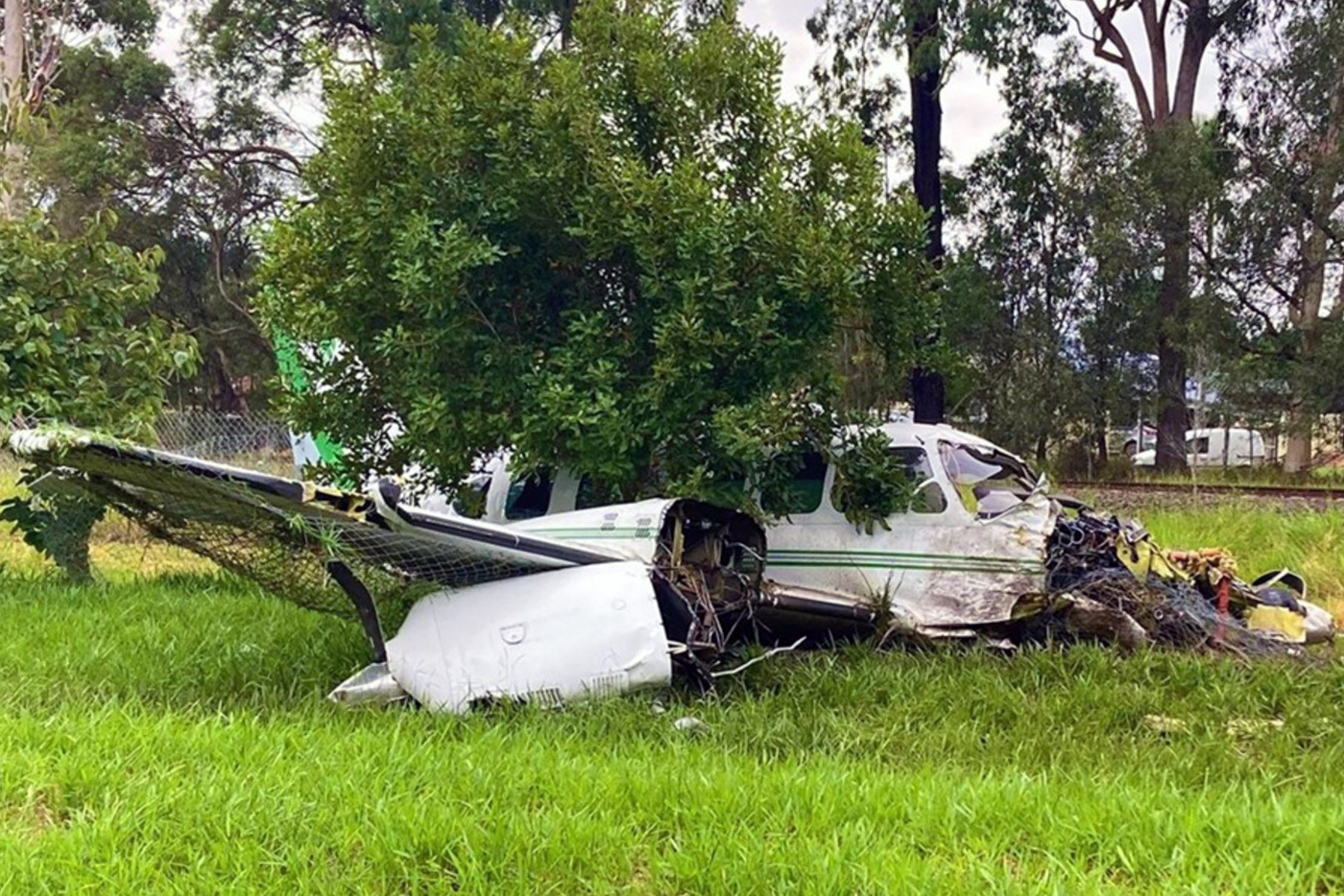
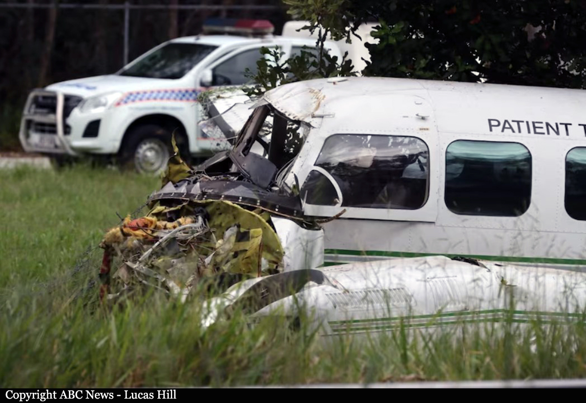
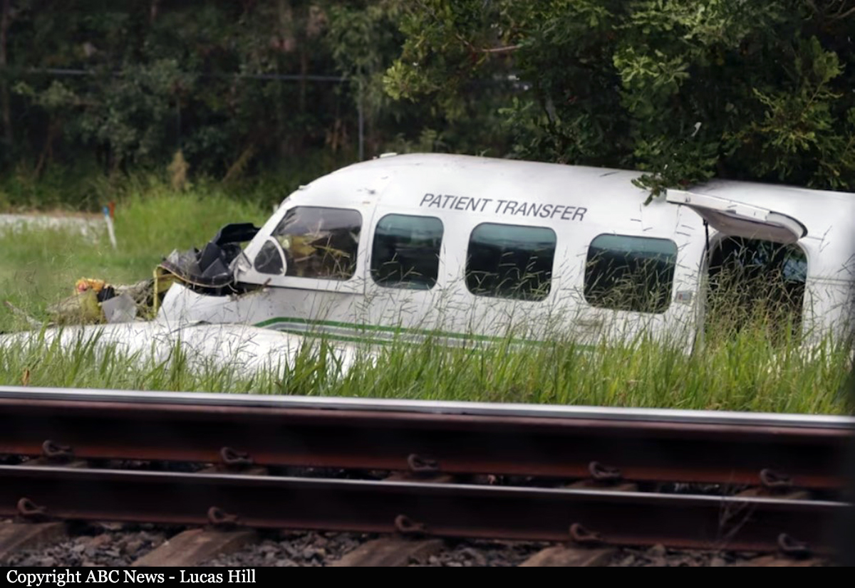
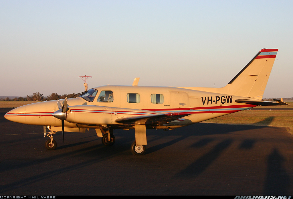
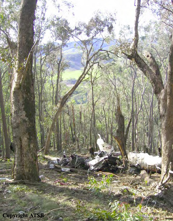
The pilot of a Cessna 340 departed Bankstown, NSW at 1223 ESuT, for Townsville, Qld via Walgett, St George, Roma, Emerald and Clermont. He reported that he climbed the aircraft to 16,000 ft and adopted a long range power setting of about 49% which equated to a true air speed (TAS) of 168 kts and a fuel burn of 141 lbs per hour. As the pilot approached the ‘OLDER’ waypoint north of Clermont, he reviewed his fuel situation and, because of a strong tailwind decided to continue on to Cairns. He informed an enroute controller of his decision and requested, for fuel planning purposes, a clearance to allow him to track in the opposite direction on a one-way air route. The controller was unable to approve his request but offered the pilot a direct track to Biboohra, a navigation aid 20 NM west of Cairns. The pilot accepted the amended track with the intention of later requesting a more direct route to Cairns. About 15 minutes later, the pilot requested a more direct track, but was told to call the approach controller for a possible clearance. He contacted the approach controller and told the controller that he had minimum fuel. The controller asked the pilot if he was declaring an emergency, to which he replied affirmative. The pilot later commented that he did this in the hope of expediting his arrival. He was instructed to descend to 6,500 ft and track direct to Cairns. The controller asked the pilot if he preferred to join the runway 15 circuit via a left downwind or right downwind, to which the pilot requested to join a left downwind. The pilot later commented that the aircraft fuel flow gauges were indicating a total flow of 140 lbs per hour and the fuel quantity gauges for the selected main tanks, although wandering somewhat, were ‘displaying a healthy amount’ considering that he was about 12 NM from his destination. As the pilot approached 6,500 ft, he requested a clearance for further descent, to which the controller instructed the pilot to descend to 4,000 ft. As the aircraft descended to 4,000 ft, the pilot saw Cairns City, but could not see the runway at Cairns airport. The aircraft's distance measuring equipment (DME) indicated 9 NM to the DME navigation aid at Cairns Airport. The pilot reported that at about this time, he observed one of the fuel flow gauges indicating zero, while at the same time, one or both engines began to surge and run roughly. He immediately informed the controller of the situation. The controller asked the pilot if he was familiar with a local airstrip (Greenhill which is 10 NM to the southeast of Cairns airport), to which the pilot replied that he wasn't. The controller indicated to the pilot that the strip was situated in his two o'clock position at a range of about two miles and to be aware of power lines and the sugar cane. The pilot was unsure of what to look for and was unable to see the strip, but after conducting a number of steep turns, saw a cleared strip in a field. He decided that he had to land. He extended the landing gear, but realised that the aircraft was too high and attempted a 360-degree steep turn onto final to reposition the aircraft. However, the airspeed was rapidly decreasing and there was insufficient height to complete the approach. At 1729 EST, the aircraft impacted the ground short of the strip and slid for about 20 metres. The pilot was seriously injured and the passengers received minor injuries.
Probable cause:
The reason for the initial fuel flow fluctuations was not identified by the pilot. It is likely that the pilot assumed the zero reading indicated impending fuel exhaustion and concentrated on conducting a landing in unfamiliar terrain. During the landing approach the pilot lost control of the aircraft and it descended rapidly to the ground.
Final Report:

Crash of a Mitsubishi MU-2B-30 Marquise in Bathurst: 1 killed

Date & Time: Nov 7, 1990
Type of aircraft:
Registration:
VH-WMU
Flight Type:
Survivors:
No
Schedule:
Bankstown - Bathurst
MSN:
512
YOM:
1970
Country:
Region:
Crew on board:
1
Crew fatalities:
Pax on board:
0
Pax fatalities:
Other fatalities:
Total fatalities:
1
Circumstances:
Crashed on approach in foggy conditions while performing a cargo flight from Bankstown with bank notes on board. The pilot, sole on board, was killed.

Crash of a Piper PA-31-310 Navajo C in Benalla

Date & Time: Jul 16, 1986 at 1818 LT
Type of aircraft:
Operator:
Registration:
VH-UCK
Flight Phase:
Flight Type:
Survivors:
Yes
Schedule:
Benalla – Bankstown
MSN:
31-7712029
YOM:
1977
Country:
Region:
Crew on board:
2
Crew fatalities:
Pax on board:
2
Pax fatalities:
Other fatalities:
Total fatalities:
0
Circumstances:
At the time of the attempted take-off, the night was dark, with overcast cloud conditions and light rain falling. Wind conditions were light and variable. The pilot reported that initial acceleration was normal, and the aircraft became airborne at about 95 knots. A positive rate of climb was established and the landing gear was selected up. The pilot subsequently advised that the speed then decayed to 90 knots. At this time there was nothing unusual in the engine noise and the controls felt normal. Shortly afterwards the propellers struck the ground 116 metres beyond the end of the runway. The aircraft then struck an embankment and passed through a fence before coming to rest 247 metres from the initial ground strike. All four occupants escaped with minor injuries and the aircraft was destroyed.
Probable cause:
Although wind conditions were light and variable when the engines were started, shortly after the accident the wind was moderate from the west/south-west. A detailed analysis conducted by the Bureau of Meteorology indicated that while the pilot was preparing for take-off, a cold front with winds in excess of 20 knots had probably passed over the aerodrome. As the pilot had conducted the take-off on runway 08, there was probably a substantial tailwind component. Conditions were also assessed as suitable for the development of microbursts, but the lack of recording instruments in the area prevented confirmation that this type of phenomenon had in fact occurred. The pilot had been deprived of the opportunity to observe changing wind conditions at the aerodrome. The wind direction indicator adjacent to the threshold of runway 08 was not lit, and the illuminated wind direction indicator was not visible from the point where the aircraft was lined up for take-off.
Final Report:

Crash of a Mitsubishi MU-2B-60 Marquise in Bargo: 1 killed

Date & Time: May 24, 1983 at 0433 LT
Type of aircraft:
Operator:
Registration:
VH-MLU
Flight Phase:
Flight Type:
Survivors:
No
Schedule:
Sydney - Melbourne
MSN:
1527
YOM:
1981
Country:
Region:
Crew on board:
1
Crew fatalities:
Pax on board:
0
Pax fatalities:
Other fatalities:
Total fatalities:
1
Circumstances:
The aircraft was cleared via a Standard Instrument DEPARTURE with an unrestricted climb to Flight Level (FL) 220. The aircraft climbed on track at an average rate of 1300 ft/min until FL130. The rate of climb then reduced to 350 ft/min until FL140, when the rate of climb increased to 1800 ft/min. At FL160 the aircraft entered a near vertical descent and radar contact was lost one minute later at 3100 feet. The aircraft impacted the ground in a near vertical attitude. The pilot, sole on board, was killed.
Probable cause:
Despite an extensive investigation, the reason for the loss of control leading to this accident could not be determined. There have been several other reported occurrences involving sudden loss of control in this aircraft type and the United States Federal Aviation Administration has conducted a certification review of the type. The results of that review do not appear to indicate any factors relevant to this particular accident.
Final Report:

Crash of a Partenavia P.68B in Bankstown

Date & Time: Dec 23, 1980
Type of aircraft:
Operator:
Registration:
VH-IYO
Flight Phase:
Flight Type:
Survivors:
Yes
Country:
Region:
Crew on board:
1
Crew fatalities:
Pax on board:
0
Pax fatalities:
Other fatalities:
Total fatalities:
0
Circumstances:
Shortly after takeoff from Bankstown Airport, while climbing, the twin engine airplane stalled and crashed in a camping lot. The pilot, sole on board, was injured. There were no injuries on ground.

Crash of a Britten-Norman BN-2A Trislander Mk.III-2 near Tumut: 2 killed

Date & Time: Dec 16, 1980
Type of aircraft:
Registration:
VH-EGU
Flight Phase:
Flight Type:
Survivors:
No
Site:
Schedule:
Bankstown - Melbourne
MSN:
1030
YOM:
1976
Country:
Region:
Crew on board:
1
Crew fatalities:
Pax on board:
1
Pax fatalities:
Other fatalities:
Total fatalities:
2
Circumstances:
While flying over the Snowy Mountains on a cargo flight from Bankstown to Melbourne, the pilot reported icing conditions. Shortly later, the three engine airplane went out of control and crashed in a wooded area. The aircraft was destroyed and both occupants were killed. It was later reported that a cold front was coming across the area with low temperatures and icing conditions.
Probable cause:
It is believed that the loss of control was the consequence of an excessive accumulation of ice on airframe as well as on carburetors.

Crash of a Piaggio P.166AL-1 Albatross near Marulan: 1 killed

Date & Time: Feb 22, 1977 at 0755 LT
Type of aircraft:
Operator:
Registration:
VH-GOC
Flight Phase:
Flight Type:
Survivors:
No
Site:
Schedule:
Bankstown - Warracknabeal
MSN:
403
YOM:
1961
Country:
Region:
Crew on board:
1
Crew fatalities:
Pax on board:
0
Pax fatalities:
Other fatalities:
Total fatalities:
1
Captain / Total flying hours:
12000
Captain / Total hours on type:
1200.00
Circumstances:
The pilot attended the Bankstown Briefing Office at about 0600 hours. He was briefed concerning the current weather conditions at Bankstown Airport, which were Instrument Meteorological Conditions (IMC) but were Improving to VMC; and the relevant meteorological forecasts which indicated, for his proposed route, that he might experience some difficulty in maintaining flight In Visual Meteorological Conditions (VMC). The pilot's licence was not endorsed to permit him to operate in other than VMC. He then submitted a flight plan for a flight from Bankstown Airport to Warracknabeal and return, proceeding over Marulan the estimated time interval thereto being 33 minutes, the flight to be conducted in accordance with the Visual Flight Rules (VFR) at altitudes not exceeding 5000 feet. The aircraft departed Bankstown Airport, in VMC, and established two way communication with Sydney Flight Service Unit (FSU). At 0748 hours the pilot advised the Sydney FSU that he was "returning to Camden, estimating Camden at one five". In response to a query the pilot advised "weather okay". No further communications were received from the aircraft. At about 0755 hours the aircraft was heard and observed flying in an easterly direction some 20 kilometres north-northeast of Marulan. There was low cloud and some light rain in the area. The aircraft was flying below the cloud base and was at a height of 500 feet to 200 feet above undulating terrain, proceeding towards rugged terrain which was gradually rising. Subsequently the aircraft proceeded over a ridge line out of the sight of witnesses. Shortly thereafter the engine noise ceased abruptly. The police were alerted and search and rescue action was initiated. The wreckage of the aircraft was located some eight hours later. The aircraft had crashed on a heavily timbered 12 degree upslope about 100 feet below a ridge line. At Impact the aircraft was in a nose down attitude and was banked some 45 degrees to the right. The right hand propeller was feathered and the engine had not been operating at impact. The left hand engine had been under power. The landing gear and flaps had been fully retracted. The available evidence Indicates that the gross weight of the aircraft was at or about the maximum permissible all up weight. Examination of the right hand engine revealed massive internal failure which had commenced with the failure of the right hand dowel In the Number 2 main crankcase bearing. It is probable that the dowel failed because of abnormal loads resulting from loss of bearing nip associated with crankcase fretting at the lower through bolt of the Number 2 bearing saddle. It is estimated that the engine had operated some 170 hours since issue of the last maintenance release on 26 October 1976.
Probable cause:
The probable cause of the accident was that, in the conditions pertaining, the single engine performance of the aircraft was insufficient to ensure maintenance of adequate terrain clearance whilst flying over undulating terrain at a low eight. Internal structural failure of right hand engine, Lycomtng GSO480-BIC6 Serial number L3050-33. Left hand engine carburettor air temperature control valve detached from actuating shaft.
Final Report: